


-
摘要:
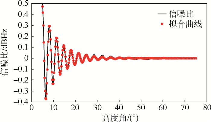
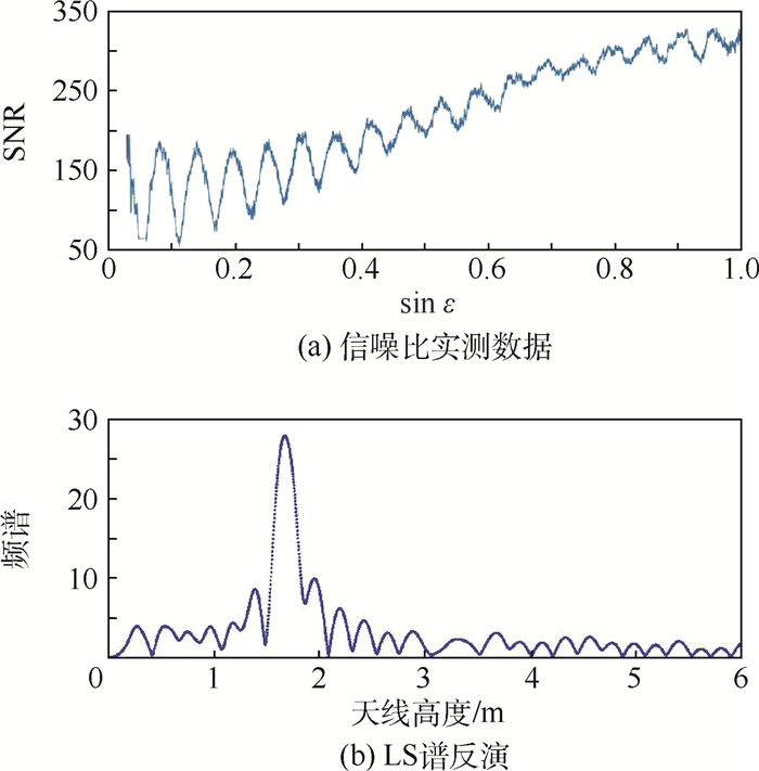
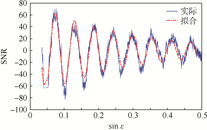
提出利用全球导航卫星系统反射信号的干涉方法(GNSS-IR)进行测高。深入分析全球导航卫星系统反射信号的多径信号模型(GNSS-MR),在此基础上提出单天线测高模型,旨在获取多径信号信噪比(SNR)频率信息,从而反演出高度信息。Lomb-Scargle(LS)谱分析方法是单天线测高模型中常用的频率提取方法;提出了基于解析模型拟合的方法对多径信号信噪比数据提取频率,同样可以准确获取频率信息,从而反演出天线到地面的高度。在此基础上,讨论了单天线测高的最大测量高度和接收机需要满足的最小输出率。由实验数据分析得出:传统LS谱分析方法和拟合法在反演效果最优时,即LS谱分析方法在高度角上限为17°时,均方根误差为0.028 75 m;拟合法在高度角上限为21°时,均方根误差为0.024 85 m。通过比较不同高度角上限的均方根误差,可以获得最优化的高度反演条件,同时也表明了拟合法的可行性。
Abstract:The method of global navigation satellite system-interferometric reflection (GNSS-IR) was developed to realize the altimetry. The model of global navigation satellite system-multipath reflection (GNSS-MR) was analyzed in depth. A single antenna height measurement model was proposed to obtain the signal-to-noise ratio (SNR) and frequency information of multipath signals, so as to reverse the height information. The Lomb-Scargle (LS) periodogram is a commonly used extraction method of the height measurement model of single antenna. In this paper, a new method based on analytic model fitting method was proposed and the frequency information can be acquired accurately for the SNR of the multipath signals. Thus the height of antenna to ground was reversed. On this basis, the maximum measurement height and the minimum output rate required by the receiver were discussed. From the analysis of experimental data, it can be concluded that when the best results of inversion are obtained, that is, as for LS periodogram, when the upper limit of elevation angle reaches to 17°, the RMSE is 0.028 75 m; as for the fitting method, when the upper limit reaches to 21°, the RMSE is 0.024 85 m. By comparing the RMSE of different upper limit of elevation angle, the best condition of height inversion can be retrieved. And it can also prove the practicability of the fitting method.
-

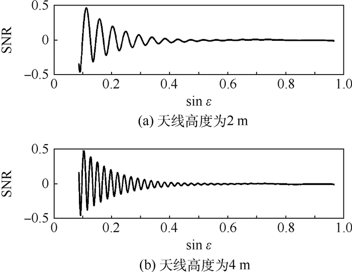
图 3 不同天线高度时的信噪比仿真波形
Figure 3. Simulation waveforms of SNR at different antenna heights

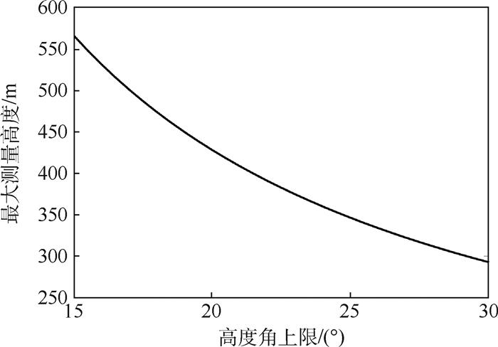
图 4 最大测量高度与高度角上限关系
Figure 4. Relationship between maximum measured height and upper limit of elevation angle

图 5 最小接收机输出率与测量高度关系
Figure 5. Relationship between minimum output rate of receiver and measured height
-
[1] CARRENOLUENGO H, CAMPS A.Empirical results of a surface-level GNSS-R experiment in a wave channel[J].Remote Sensing, 2015, 7(6):7471-7493. doi: 10.3390/rs70607471 [2] D'ADDIO S, MARTIN-NEIRA M, BISCEGLIE M D, et al.GNSS-R altimeter based on Doppler multi-looking[J].IEEE Journal of Selected Topics in Applied Earth Observations & Remote Sensing, 2014, 7(5):1452-1460. http://ieeexplore.ieee.org/document/6777324/ [3] ZAVOROTNY V U, LARSON K M, BRAUN J J, et al.A physical model for GPS multipath caused by land reflections:Toward bare soil moisture retrievals[J].IEEE Journal of Selected Topics in Applied Earth Observations & Remote Sensing, 2010, 3(1):100-110. http://ieeexplore.ieee.org/document/5290072/ [4] VEY S, GVNTNER A, WICKERT J, et al.Monitoring snow depth by GNSS reflectometry in built-up areas:A case study for Wettzell, Germany[J].IEEE Journal of Selected Topics in Applied Earth Observations & Remote Sensing, 2016, 9(10):4809-4816. http://ieeexplore.ieee.org/document/7399701/ [5] LARSON K M, SMALL E E, GUTMANN E, et al.Using GPS multipath to measure soil moisture fluctuations:Initial results[J].GPS Solutions, 2008, 12(3):173-177. doi: 10.1007/s10291-007-0076-6 [6] CHEW C C, SMALL E E, LARSON K M, et al.Effects of near-surface soil moisture on GPS SNR data:Development of a retrieval algorithm for soil moisture[J].IEEE Transactions on Geoscience & Remote Sensing, 2013, 52(1):537-543. http://ieeexplore.ieee.org/document/6479284/ [7] VEY S, GVNTNER A, WICKERT J, et al.Long-term soil moisture dynamics derived from GNSS interferometric reflectometry:A case study for Sutherland, South Africa[J].GPS Solutions, 2016, 20(4):641-654. doi: 10.1007/s10291-015-0474-0 [8] 敖敏思, 胡友健, 刘亚东, 等.GPS信噪比观测值的土壤湿度变化趋势反演[J].测绘科学技术学报, 2012, 29(2):140-143. http://www.cqvip.com/QK/98086B/201202/41812028.htmlAO M S, HU Y J, LIU Y D, et al.Inversion of soil moisture fluctuation based on signal-to-noise ratio of global positioning system[J].Journal of Geomatics Science and Technology, 2012, 29(2):140-143(in Chinese). http://www.cqvip.com/QK/98086B/201202/41812028.html [9] LARSON K M, GUTMANN E D, ZAVOROTNY V U, et al.Can we measure snow depth with GPS receivers [J].Geophysical Research Letters, 2009, 36(17):L17502. doi: 10.1029/2009GL039430 [10] LARSON K M, SMALL E E.Estimation of snow depth using L1 GPS signal-to-noise ratio data[J].IEEE Journal of Selected Topics in Applied Earth Observations & Remote Sensing, 2016, 9(10):4802-4808. http://ieeexplore.ieee.org/document/7373531/ [11] ROUSSEL N, RAMILLIEN G, FRAPPART F, et al.Sea level monitoring and sea state estimate using a single geodetic recei-ver[J].Remote Sensing of Environment, 2015, 171:261-277. doi: 10.1016/j.rse.2015.10.011 [12] NIEVINSKI F G, LARSON K M.Forward modeling of GPS multipath for near-surface reflectometry and positioning applications[J].GPS Solutions, 2014, 18(2):309-322. doi: 10.1007/s10291-013-0331-y [13] NIEVINSKI F G, LARSON K M.An open source GPS multipath simulator in MATLAB/octave[J].GPS Solutions, 2014, 18(3):1-9. doi: 10.1007/s10291-014-0370-z [14] LOMB N R.Least-squares frequency analysis of unequally spaced data[J].Astrophysics and Space Science, 1976, 39(2):447-462. doi: 10.1007/BF00648343 [15] 徐斌, 杨涛, 谭保华, 等.基于Lomb-Scargle算法的周期信号探测的模拟研究[J].核电子学与探测技术, 2011, 31(6):702-705. http://mall.cnki.net/magazine/Article/HERE201106025.htmXU B, YANG T, TAN B H, et al.The simulate study of signal detection based on Lomb-Scargle algorithm[J].Nuclear Electronics & Detection Technology, 2011, 31(6):702-705(in Chiense). http://mall.cnki.net/magazine/Article/HERE201106025.htm [16] ROUSSEL N, FRAPPART F, RAMILLIEN G, et al. Detection of soil moisture content changes by using a single geodetic antenna: The case of an agricultural plot[C]//Geoscience and Remote Sensing Symposium. Piscataway, NJ: IEEE Press, 2015: 2008-2011. [17] ROUSSEL N, FRAPPART F, RAMILLIEN G, et al.Detection of soil moisture variations using GPS and GLONASS SNR data for elevation angles ranging from 2° to 70°[J].IEEE Journal of Selected Topics in Applied Earth Observations & Remote Sensing, 2016, 9(10):1-14. http://ieeexplore.ieee.org/document/7446285/ -

 下载:
下载:


 点击查看大图
计量
- 文章访问数: 778
- HTML全文浏览量: 84
- PDF下载量: 376
- 被引次数: 0
