


Low-altitude remote sensing image registration algorithm based on dual-feature for arable land in hills and mountains
-
摘要:
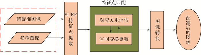
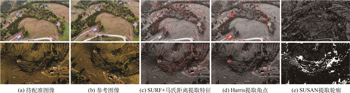
针对丘陵山区耕地小型无人机航拍图像(低空遥感图像)中的尺度变化、几何畸变、图像重叠等问题,提出了基于双特征的丘陵山区耕地低空遥感图像配准算法。该算法鉴于丘陵山区耕地背景环境复杂、光照因素等影响,采用尺度不变特征SURF算法提取了遥感图像的特征点,并构建了能够稳健描述航拍图像几何特征的双特征描述子;在此基础上,以高斯混合模型(GMM)为核心,结合2个单一特征差异描述子(基于欧氏距离的全局特征和基于和向量的局部特征)构造的双特征描述子,得到了能够同时通过2种特征进行对应关系评估的双特征有限混合模型(DFMM),并通过再生核希尔伯特空间(RKHS),基于高斯径向基函数(GRBF)对待配准图像进行了全局与局部结构双约束的空间变换更新。为了验证本文算法的可行性及其性能,采用小型无人机航拍的丘陵山区坡耕地多视角遥感图像开展了实验,将本文算法与SIFT、SURF、CPD、AGMReg、GLMDTPS及PRGLS进行了比较。实验结果表明,本文算法不仅在不同坡度的坡耕地航拍图像多视角配准过程中,均具有较好的鲁棒性,也适用于部分复杂地形小型无人机航拍的多视角遥感图像配准。
-
关键词:
- 图像配准 /
- 小型无人机 /
- 双特征 /
- 有限混合模型 /
- 再生核希尔伯特空间(RKHS)
Abstract:Small unmanned aerial vehicle (UAV) aerial images (low-altitude remote sensing image) of arable land in hills and mountains are confronted with multiple challenges of image processing due to its scale change, geometric distortion and image overlap. To address the problems, the low-altitude remote sensing image registration algorithm based on dual-feature for arable land in hills and mountains was proposed. Due to the complex environment and the influence of light factors in hills and mountains, the feature points of remote sensing images are extracted by using the scale-invariant SURF algorithm. And then the dual-feature descriptor using geometrical structure of aerial images was constructed. On this basis, by taking Gaussian mixture model (GMM) as the core and combining with two single feature difference descriptors (i.e., global distance descriptor based on euclidean distance and local structure descriptor based on sum vectors), the dual-feature finite mixture model (DFMM) was obtained, which can simultaneously evaluate the correspondence between two features. With the reproducing kernel Hilbert space (RKHS), the spatial transformation of the global and local structure of the registration image was carried out based on the Gaussian radial basis function (GRBF). In order to verify the feasibility and performance of the proposed algorithm, experiments were carried out by using UAV images with different viewpoints taken from sloping arable land in hills and mountains. Experimental results show that comparing with SIFT, SURF, CPD, AGMReg, GLMDTPS and PRGLS, our method provides better performances in most cases, and can apply to multi-view remote sensing image registration of other complex terrain by small UAV.
-

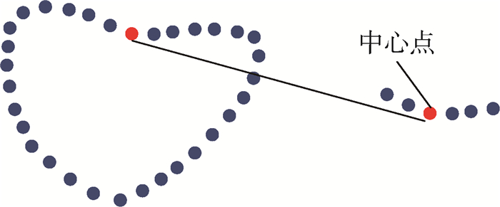
图 1 心型特征点集中某中心点与其最近相邻点(5个点)构成的局部片段
Figure 1. A central point and its nearest neighboring points(five points) construct a small fragment of heart-shaped feature points

图 4 单一特征与混合特征(双特征)性能比较
Figure 4. Performance comparison of single feature and mixed feature (dual-feature)

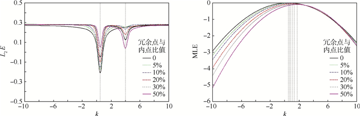
图 5 L2E与MLE随着冗余点数量的改变的鲁棒性对比
Figure 5. Variation of L2E and MLE with number of redundant point and their robustness comparison

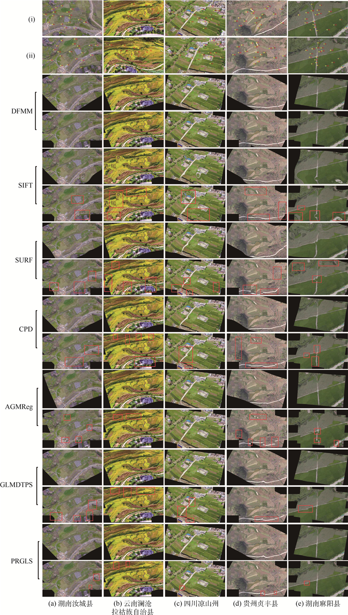
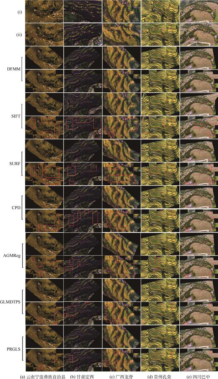
图 6 5组数据集(i)的图像配准结果示例
Figure 6. Examples of image registration results for five sets of data sets (i)

图 7 5组数据集(ii)的图像配准结果示例
Figure 7. Examples of image registration results for five sets of data sets (ii)
表 1 实验数据
Table 1. Experimental data
参数 (i) (ii) 坡度/(°) 6~15 15~25 实验组数 30 30 尺寸/(mm×mm) 640×450~
1 100×850640×450~
1 100×850俯角变化/(°) 30~90 30~90 水平视角/(°) -90~90 -90~90 特征点数 282~712 140~600  下载: 导出CSV
表 2 使用RMSE和MAE进行数据集(i)和(ii)实验的评估比较结果
Table 2. Experimental result of exprimental database (i) and (ii) evaluation and comparison using RMSE and MAE
误差 数据集 SURF SIFT CPD AGMReg GLMDTPS PRGLS DFMM RMSE (i) 7.283 7 12.528 7 5.436 5 5.112 3 4.919 1 3.716 3 1.321 1 (ii) 6.062 7 11.556 6 3.257 6 3.190 4 3.106 5 2.483 2 1.012 7 MAE (i) 4.234 4 7.288 9 3.110 2 3.044 0 3.058 1 2.038 0 1.074 9 (ii) 5.441 1 6.008 0 2.239 4 2.170 2 2.103 8 1.504 5 0.645 2
下载: 导出CSV
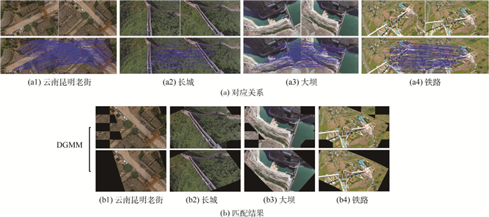
表 3 使用RMSE和MAE进行复杂地形低空遥感图像实验的评估实验结果
Table 3. Experimental results of low-altitude remote sensing images with complex terrain evaluation using RMSE and MAE
误差 云南昆明老街 长城 大坝 铁路 均值 RMSE 1.874 1 1.231 8 1.042 3 1.453 6 1.400 5 MAE 1.321 6 1.875 7 1.031 0 1.234 2 1.365 6
下载: 导出CSV
-
[1] 易中懿, 曹光乔, 张宗毅.我国南方丘陵山区农业机械化宏观影响因素分析[J].农机化研究, 2010, 32(8):229-233. doi: 10.3969/j.issn.1003-188X.2010.08.059YI Z Y, CAO G Q, ZHANG Z Y.Analysis of macro factors influencing agricultural mechanization in hilly and mountainous areas of China[J].Journal of Agricultural Mechanization, 2010, 32(8):229-233(in Chinese). doi: 10.3969/j.issn.1003-188X.2010.08.059 [2] 祝功武.南方丘陵山区耕地现状, 潜力与开发对策:以德庆县为例[J].地理科学, 1998, 18(1):10-15. http://www.cnki.com.cn/Article/CJFDTotal-DLKX801.001.htmZHU G W.Status quo hilly area south of arable land, potential and development strategies:A case study in Deqing county[J].Geographical Sciences, 1998, 18(1):10-15(in Chinese). http://www.cnki.com.cn/Article/CJFDTotal-DLKX801.001.htm [3] 吴兆娟, 魏朝富, 丁声源.丘陵山区地块尺度耕地社会保障功能价值研究[J].资源科学, 2013, 35(4):95-103. http://d.old.wanfangdata.com.cn/Periodical/zykx201304012WU Z J, WEI Z F, DING S Y.Study on the social security function value of cultivated land in the hilly area of the mountainous region[J].Resources Science, 2013, 35(4):95-103(in Chinese). http://d.old.wanfangdata.com.cn/Periodical/zykx201304012 [4] 杨邦杰, 裴志远, 周清波, 等.我国农情遥感监测关键技术研究进展[J].农业工程学, 2002, 18(3):191-194. doi: 10.3321/j.issn:1002-6819.2002.03.045YANG B J, PEI Z Y, ZHOU Q B, et al.Study on key technology of remote sensing monitoring in China[J].Journal of Agricultural Engineering, 2002, 18(3):191-194(in Chinese). doi: 10.3321/j.issn:1002-6819.2002.03.045 [5] 汪沛, 罗锡文, 周志艳, 等.基于微小型无人机的遥感信息获取关键技术综述[J].农业工程学报, 2014, 30(18):1-12. doi: 10.3969/j.issn.1002-6819.2014.18.001WANG P, LUO X W, ZHOU Z Y, et al.Study on key technology of remote sensing information acquisition based on micro-UAV[J].Journal of Agricultural Engineering, 2014, 30(18):1-12(in Chinese). doi: 10.3969/j.issn.1002-6819.2014.18.001 [6] HARRIS C.A combined corner and edge detector[J].Alvey Vision Conference, 1988(3):147-151. http://cn.bing.com/academic/profile?id=ec9aac7ea843efb9b6a9b356e4d49d22&encoded=0&v=paper_preview&mkt=zh-cn [7] LOWE D G.Distinctive image features from scale-invariant keypoints[J].International Journal of Computer Vision, 2004, 60(2):91-110. doi: 10.1023/B:VISI.0000029664.99615.94 [8] BAY H, ESS A, TUYTELAARS T, et al.Speeded-up robust features[J].Computer Vision and Image Understanding, 2008, 110(3):404-417. http://d.old.wanfangdata.com.cn/Periodical/xtgcydzjs200911039 [9] BROOK A, BENDOR E.Automatic registration of airborne and spaceborne images by topology map matching with SURF processor algorithm[J].Remote Sensing, 2011, 3(1):65-82. doi: 10.3390/rs3010065 [10] ZHAO L Y, LYU B Y, LI X R, et al.Multi-source remote sensing image registration based on SIFT and optimization of regional mutual information[J].Acta Physica Sinica, 2015, 64(12):124204. http://d.old.wanfangdata.com.cn/Periodical/wlxb201512017 [11] LEI T, LI L, KAN G, et al.Automatic registration of unmanned aerial vehicle remote sensing images based on an improved SIFT algorithm[C]//Eighth International Conference on Digital Image Processing.Chengdu: ICDIP, 2016: 100333R. [12] 乔川, 丁亚林, 许永森, 等.基于地理位置信息的图像配准方法及精度分析[J].光学学报, 2017, 37(8):318-328. http://www.wanfangdata.com.cn/details/detail.do?_type=perio&id=QKC20172017091300102081QIAO C, DING Y L, XU Y S, et al.Image registration method and precision analysis based on geographic location information[J].Acta Optica Sinica, 2017, 37(8):318-328(in Chinese). http://www.wanfangdata.com.cn/details/detail.do?_type=perio&id=QKC20172017091300102081 [13] MYRONENKO A, SONG X.Point set registration:Coherent point drift[J].IEEE Transactions on Pattern Analysis and Machine Intelligence, 2010, 32(12):2262-2275. doi: 10.1109/TPAMI.2010.46 [14] GREENGARD L, STRAIN J.The fast Gauss transform[J].SIAM Journal of Scientific and Statistical Computing, 1991, 12(1):79-94. doi: 10.1137/0912004 [15] MARKOVSKY I.Structured low-rank approximation and its applications[J].Automatica, 2008, 44(4):891-909. doi: 10.1016/j.automatica.2007.09.011 [16] WANG G, WANG Z, CHEN Y, et al.Robust point matching method for multimodal retinal image registration[J].Biomedical Signal Processing and Control, 2015, 19:68-76. doi: 10.1016/j.bspc.2015.03.004 [17] YANG Y, ONG S H, FOONG K W C.A robust global and local mixture distance based non-rigid point set registration[J].Pattern Recognition, 2015, 48(1):156-173. doi: 10.1016/j.patcog.2014.06.017 [18] MA J, ZHAO J, YUILLE A L.Non-rigid point set registration by preserving global and local structures[J].IEEE Transactions on Image Processing, 2016, 25(1):53-64. doi: 10.1109/TIP.2015.2467217 [19] SCOTT D W.Parametric statistical modeling by minimum integrated square error[J].Technometrics, 2001, 43(3):274-285. doi: 10.1198/004017001316975880 [20] SEVERINI T A.Robust and efficient estimation by minimising a density power divergence[J].Biometrika, 1998, 85(3):549-559. doi: 10.1093/biomet/85.3.549 [21] MA J Y, ZHAO J W, TIAN J, et al.Robust estimation of nonrigid transformation for point set registration[C]//IEEE Conference on Computer Vision and Recognition. Piscataway, NJ: IEEE Press, 2013: 2147-2154. [22] YUILLE A L, GRZYWACZ N M.A Mathematical analysis of the motion coherence theory[J].International Journal of Computer Vision, 1989, 3(2):155-175. doi: 10.1007/BF00126430 [23] GROETSCH C W.The theory of Tikhonov regularization for fredholm equations of the first kind[M].Boston:Pitman Advanced Publishing Program, 1984:98-100. [24] ARONSZAJN N.Theory of reproducing Kernels[J].Transactions of the American Mathematical Society, 1950, 68(3):337-404. doi: 10.1090/S0002-9947-1950-0051437-7 [25] ZITOVA B, FLUSSER J.Image registration methods:A survey[J].Image and Vision Computing, 2003, 21(11):977-1000. doi: 10.1016/S0262-8856(03)00137-9 [26] 范玉芳, 罗友进, 魏朝富.西南丘陵山区坡耕地水平梯田工程设计分析[J].山地学报, 2010, 28(5):560-565. doi: 10.3969/j.issn.1008-2786.2010.05.008FAN Y F, LUO Y J, WEI C F.Design and analysis of horizontal terraces of sloping land in hilly and hilly areas of southwest China[J].Acta Terrestrial Journal, 2010, 28(5):560-565(in Chinese). doi: 10.3969/j.issn.1008-2786.2010.05.008 [27] 马芊红, 张光辉, 耿韧, 等.我国水蚀区坡耕地土壤重金属空间分布及其污染评价[J].水土保持研究, 2017, 24(2):112-118. http://d.old.wanfangdata.com.cn/Periodical/stbcyj201702020MA Q H, ZHANG G H, GENG R, et al.Spatial distribution and pollution assessment of heavy metals in slope farmland of water erosion area in China[J].Journal of Soil and Water Conservation, 2017, 24(2):112-118(in Chinese). http://d.old.wanfangdata.com.cn/Periodical/stbcyj201702020 [28] 陈伟, 朱继平, 陈小兵, 等.我国坡耕地农业机械化发展现状[J].农机化研究, 2017, 39(5):1-5. doi: 10.3969/j.issn.1003-188X.2017.05.001ZHU W, ZHU J P, CHEN X B, et al.China's sloping farmland agricultural mechanization development status[J].Agricultural Mechanization Research, 2017, 39(5):1-5(in Chinese). doi: 10.3969/j.issn.1003-188X.2017.05.001 -

 下载:
下载:


 点击查看大图
计量
- 文章访问数: 621
- HTML全文浏览量: 140
- PDF下载量: 536
- 被引次数: 0
