


-
摘要:
地基增强系统(GBAS)基准站的布设方式会直接影响系统精度与完好性,且与机场环境、卫星星座以及当地电离层活动情况密切相关。然而,美国联邦航空管理局(FAA)发布的GBAS选址标准只是给出了基准站布设的基本要求,没有深入考虑上述因素的影响。因此,GBAS基准站布设方案设计与评估方法需要进一步研究。首先,基于采集数据比较分析了5个机场典型GBAS基准站布设和伪距校正误差标准差。然后,结合理论和仿真研究了基准站个数对GBAS性能的影响,以及基线长度对星历故障监视和异常电离层梯度监视性能的影响。最后,提出一种GBAS基准站布设方案设计和评估方法,并辅以Ⅴ型跑道的4个方案示例,为根据机场实际情况、GBAS星历故障监视和异常电离层梯度监视实际需求等设计和选择合适的方案提供参考。
Abstract:The layout of ground-based augmentation system (GBAS) reference stations will directly impact the accuracy and integrity performance of GBAS, and it is closely related to the airport conditions, the satellite constellations used and the local ionospheric environment. However, the published documents such as Federal Aviation Administration (FAA) GBAS siting order only give basic requirements of reference station layout and do not deeply take the impact of the above points into account. Therefore, the study on design and evaluation strategy for GBAS reference station layout is very important. By comparing the different GBAS reference station layouts and the broadcast pseudorange correction error standard deviations of five airports based on collected data, analyzing the impact of the number of reference stations on the GBAS protection levels, and studying the impact of baseline length on the performance of ephemeris fault monitor and anomalous ionospheric gradient monitor, a design and evaluation strategy for GBAS reference station layout is proposed, which is supplemented by four sample schemes for Ⅴ-shape runways. The proposed strategy can provide a reference for the design and determination of appropriate layouts based on specific airport conditions and the requirements of ephemeris fault monitor and anomalous ionospheric gradient monitor.
-

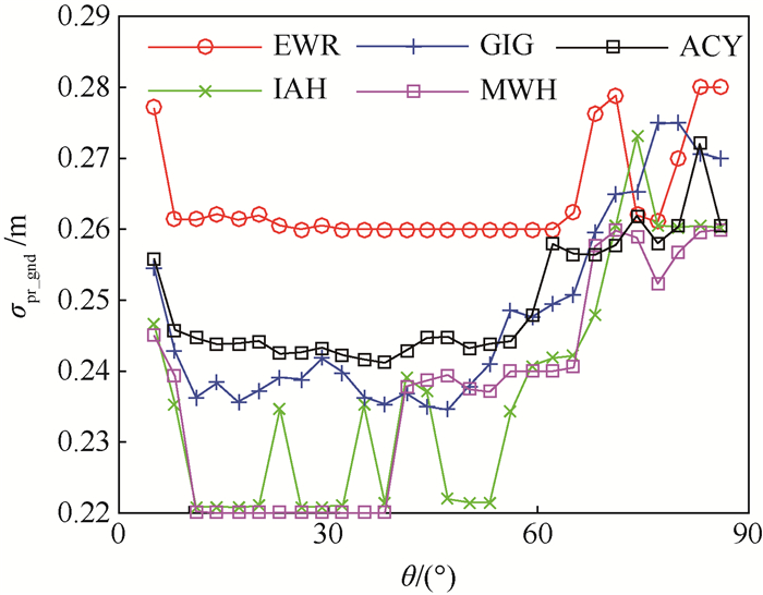
图 4 GIG B值异常与正常时间下σpr_gnd比较
Figure 4. Comparison of σpr_gnd values of GIG B-valuebetween fault-occurrence time and normal time

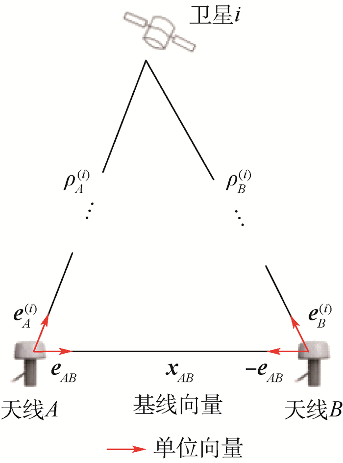
图 5 2个基准天线与卫星的几何关系
Figure 5. Geometric relationship between two reference antennas and a satellite

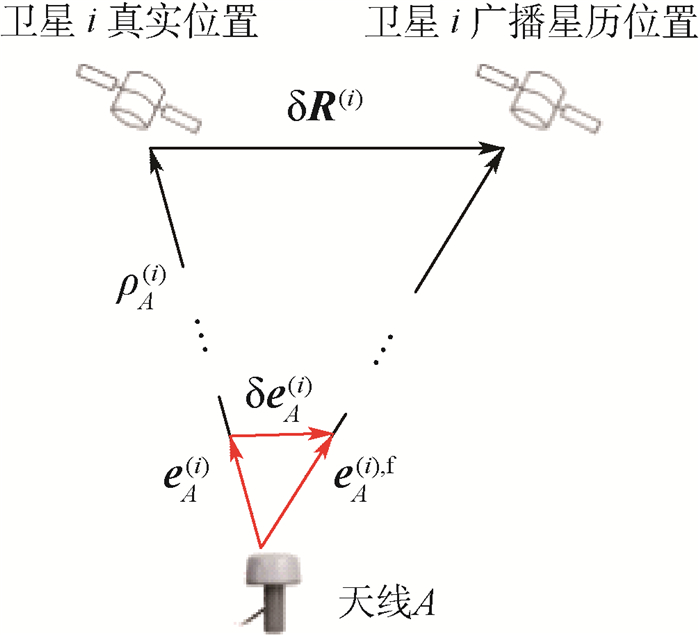
图 6 星历故障条件下天线与卫星的几何关系
Figure 6. Geometric relationship between antenna and satellite under an ephemeris fault

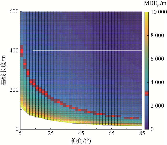
图 7 MDEE与基线长度和卫星仰角的关系
Figure 7. MDEE as a function of baseline length and satellite elevation

图 8 有效基线与跑道方向的关系
Figure 8. Relationship between effective baseline and runway direction

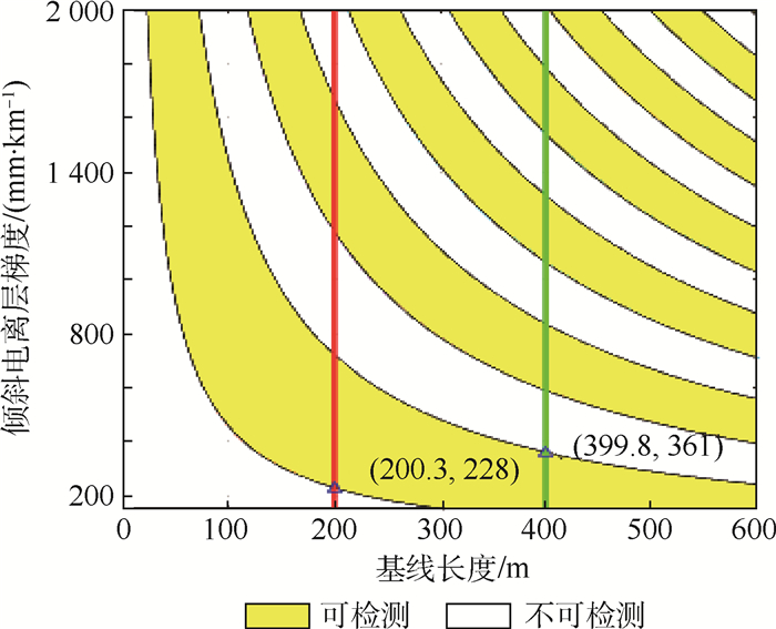
图 9 可检测电离层梯度范围与基线长度关系
Figure 9. Relationship between detectable ionospheric slant gradient range and baseline length

图 11 机场限制下GBAS基准站布设方案示例C和D
Figure 11. Sample GBAS reference station layout schemes C and D under limited airport conditions

图 12 4种方案可监测电离层梯度范围
Figure 12. Detectable ionospheric slant gradient ranges of four schemes
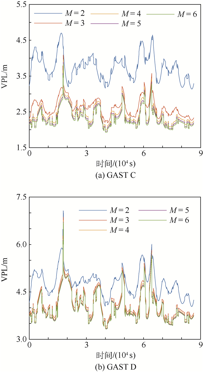
表 1 不同基准站数目下Kffmd和Kmd取值
Table 1. Values of Kffmd and Kmd for different numbers of reference stations
乘积因子 基准站数目 2 3 4 5 6 Kffmd 5.762 5.810 5.847 5.877 5.903 Kmd 2.935 2.898 2.878 2.865 2.856  下载: 导出CSV
表 2 VPL随基准站数目增大而减小的百分比统计
Table 2. Decreasing VPL percentage as number of reference stations increases
M VPL减小百分比 GAST C GAST D 2 →3 42.66 16.88 3 →4 8.70 1.51 4 →5 2.66 0.83 5 →6 1.78 0.49
下载: 导出CSV
表 3 4种方案6条基线有效长度以及MDEE值
Table 3. Effective lengths and ephemeris monitor MDEE of six baselines in four schemes
m 方案 参数 l12 l13 l14 l23 l24 l34 A 有效长度 256 400 164.55 144 91.45 235.45 MDEE 1754 1123 2730 3120 4915 1907 B 有效长度 400 544 257.12 144 142.88 286.88 MDEE 1123 826 1747 3120 3144 1566 C 有效长度 122 200 78.42 78 43.58 121.58 MDEE 3683 2247 5750 5782 10404 3697 D 有效长度 200 322 128.56 122 71.44 193.44 MDEE 2247 1395 3499 3683 6290 2322
下载: 导出CSV
表 4 星历MDEE、电离层梯度监视范围统计结果
Table 4. Statistics of ephemeris monitor MDEE and detectable ionospheric slant gradient ranges
方案 MDEE 电离层梯度监视 极大值/m 极小值/m 均值/
mMDEE < 3000m占比/% 范围/(mm·km-1) 范围在[0, 2000]mm/
km占比/%A 4 915 1123 2592 66.67 [114.2, 2000] 94.29 B 3144 826 1921 66.67 [83.93, 1311]∪[1484, 2000] 87.15 C 10404 2247 5261 16.7 [228.3, 2000] 88.59 D 6290 1395 3239 50 [141.8, 2000] 92.91
下载: 导出CSV
-
[1] International GBAS Working Group (IGWG).GBAS approach & landing systems, the future of precision approach[EB/OL].(2017-04-20)[2018-01-10]. http://flygls.net/. [2] ICAO NSP.Report of the meeting of the GBAS WG (GWG): NSP3 Agenda 1[R].Montreal: ICAO, 2016. [3] GRATTON L R.Orbit ephemeris monitors for category Ⅰ local area augmentation of GPS[D].Chicago: Illinois Institute of Technology, 2003. [4] ICAO NSP/4-WP/18.Proposed change to ICAO DOC 9157 Part 6 to facilitate GBAS ground subsystem siting: NSP4 Agenda 3[R].Montreal: ICAO, 2017. [5] FAA.Siting criteria for ground based augmentation system (GBAS): 6884.1[S].Washington, D.C.: FAA, 2010. [6] SESAR.Ground architecture and airport installation: D0403.00.00[R].Ragusa: SESAR, 2013. [7] FAA.Ground based augmentation system performance analysis and activities report: Quarter 1-2016[R].Washington, D.C.: FAA, 2016. [8] DAUTERMANN T, FELUX M, GROSCH A.Approach service type D evaluation of the DLR GBAS testbed[J].GPS Solutions, 2012, 16(3):375-387. doi: 10.1007/s10291-011-0239-3 [9] RTCA.Minimum operational performance standards for GPS local area augmentation system airborne equipment: DO-253C[S].Washington, D.C.: RTCA, 2008. [10] RTCA.Minimum aviation system performance standards for the local area augmentation system(LAAS): DO-245A[S].Washington, D.C.: RTCA, 2004. [11] WANG Z, MACABIAU C, ZHANG J, et al.Prediction and analysis of GBAS integrity monitoring availability at LinZhi airport[J].GPS Solutions, 2014, 18(1):27-40. doi: 10.1007/s10291-012-0306-4 [12] RTCA.GNSS-based precision approach local area augmentation system (LAAS) signal-in-space interface control document (ICD): DO-246D[S].Washington, D.C.: RTCA, 2008. [13] PERVAN B, GRATTON L.Orbit ephemeris monitors for local area differential GPS[J].IEEE Transactions on Aerospace & Electronic Systems, 2005, 41(2):449-460. http://www.wanfangdata.com.cn/details/detail.do?_type=perio&id=b7a631111c27760142f258433edbd792 [14] ICAO NSP.Preliminary review of proposed amendments to Annex 10, Volume Ⅰ: Item No.20403[R].Montreal: ICAO, 2017. [15] AHN J, LEE Y J, WON D H, et al.Orbit ephemeris failure detection in a GNSS regional application[J].International Journal of Aeronautical & Space Sciences, 2015, 16(1):89-101. http://www.wanfangdata.com.cn/details/detail.do?_type=perio&id=JAKO201515338946366 [16] KHANAFSEH S, PULLEN S, WARBURTON J.Carrier phase ionospheric gradient ground monitor for GBAS with experimental validation[J].Navigation, 2012, 59(1):51-60. doi: 10.1002/navi.v59.1 [17] SHIVELY C A.Preliminary analysis of requirements for CAT ⅢB LAAS[C]//Proceedings of Annual Meeting of the Institute of Navigation.Albuquerque, NM: ION, 2001: 705-714. [18] PULLEN S, PARK Y S, ENGE P.Impact and mitigation of ionospheric anomalies on ground-based augmentation of GNSS[J].Radio Science, 2016, 44(1):1-10. http://www.wanfangdata.com.cn/details/detail.do?_type=perio&id=662a93eb99923d1ef239fd5e35e37935 [19] LUO M, PULLEN S, WALTER T, et al.Ionosphere spatial gradient threat for LAAS: Mitigation and tolerable threat space[C]//Proceedings of the National Technical Meeting of the Institute of Navigation.San Diego, CA: ION, 2004: 490-501. [20] ICAO NSP.GAST D siting issues paper: WP/34 Agenda 1[R].Montreal: ICAO, 2010. [21] HARRIS M, MURPHY T, SAITO S.Further validation of GAST D ionospheric anomaly mitigations[C]//Proceedings of the International Technical Meeting of the Institute of Navigation.Manassas, VA: ION, 2011, 8034(6): 942-949. [22] DATTA-BARUA S, LEE J, PULLEN S, et al.Ionospheric threat parameterization for local area GPS-based aircraft landing systems[J].Journal of Aircraft, 2010, 47(7):1141-1151. doi: 10.2514/1.46719 [23] KIM M, CHOI Y, JUN H S, et al.GBAS ionospheric threat model assessment for category Ⅰ operation in the Korean region[J].GPS Solutions, 2015, 19(3):443-456. doi: 10.1007/s10291-014-0404-6 [24] ICAO NSP/3.GBAS MC/DF verification exercises preliminary results: IP/14 Agenda 3[R].Montreal: ICAO, 2016. [25] ICAO NSP/3.Assessment of GNSS repeater impact on GBAS: WP/17 Agenda 3[R].Montreal: ICAO, 2016. [26] BELABBAS B, REMI P, MEURER M, et al.Absolute slant ionosphere gradient monitor for GAST-D: Issues and opportunities[C]//Proceedings of the International Technical Meeting of The Satellite Division of the Institute of Navigation.Manassas, VA: ION, 2011: 2993-3002. [27] WANG Z, WANG S, ZHU Y, et al.Assessment of ionospheric gradient impacts on ground-based augmentation system (GBAS) data in Guangdong province, China[J].Sensors, 2017, 17(10):2313. doi: 10.3390/s17102313 -

 下载:
下载:


 点击查看大图
计量
- 文章访问数: 633
- HTML全文浏览量: 169
- PDF下载量: 407
- 被引次数: 0
