


-
摘要:
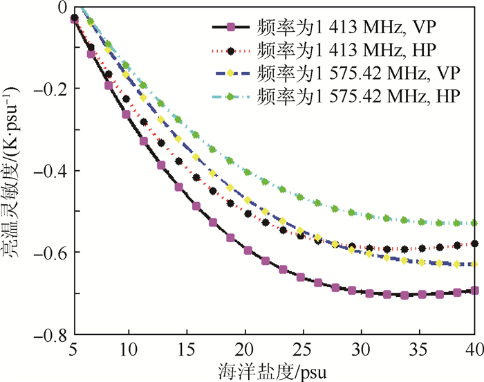
全球导航卫星系统反射计(GNSS-R)是近年来兴起的一种被动式遥感手段,可用于提高海洋盐度(SSS)反演精度。首先,在回顾辐射计亮温模型和GNSS-R散射功率模型,并建立星载仿真场景的基础上,研究了GNSS-R辅助辐射计探测海洋盐度的性能,使辐射计工作于GPS L1频点1 575.42 MHz时,通过共用天线和射频前端可以降低星载设备的质量和功耗,但对海洋盐度大于25 psu的条件下,垂直和水平极化的亮温对海洋盐度的灵敏度分别下降约0.1和0.08 K/psu;其次,分析了GPS L1反射信号对辐射计的干扰,发现在仿真场景下当辐射亮温变化1 K时,GPS L1反射信号引入了小于2.5×10⁻⁴ K的误差;再者,讨论了不同入射角情况下定义的垂直和水平极化的GNSS-R观测量对亮温校正量的灵敏度,结果表明随入射角增大,水平、垂直极化信号的观测量对亮温校正量的灵敏度分别呈现下降和上升趋势;最后,分析了定义的GNSS-R观测量对亮温校正量的灵敏度与空间分辨率之间的关系,得出了高灵敏度、高空间分辨率反演算法的研究对星载GNSS-R辅助辐射计海洋盐度探测至关重要的结论。
-
关键词:
- 全球导航卫星系统反射计(GNSS-R) /
- 海洋盐度(SSS) /
- 辅助探测 /
- 灵敏度 /
- 空间分辨率
Abstract:Global navigation satellite system-reflectometry (GNSS-R) is a new remote sensing way which is passive radar and could be used to improve the retrieval precision of the sea surface salinity (SSS). The model of brightness temperature and the scattering power model of GNSS-R were reviewed, and the spaceborne simulation scenario was developed in this paper. Based on those, the performance of GNSS-R aiding radiometer to determine SSS was first explored. Although it is possible to decrease the mass and power consumption of spaceborne equipment by sharing the antenna and radio frequency font-end between GNSS-R and radiometer working on the frequency of GPS L1 1 575.42 MHz, when SSS is larger than 25 psu, the sensitivity of brightness temperature to SSS reduces by about 0.1 and 0.08K/psu for the vertical and horizontal polarization signal respectively. The distortion of reflected GPS L1 signals on the measurement of the brightness temperature was analyzed. It is found that under the condition of the simulation scenario for 1 K variation of brightness temperature, reflected GPS L1 signals introduce error less than 2.5×10⁻⁴ K. Subsequently, the sensitivity of the GNSS-R observable to the brightness temperature variation for the vertical and horizontal polarization signal was explored. The results show that when incidence angle increases, the sensitivity of the horizontal and vertical polarization signal show falling and rising tendency respectively. Finally, the relationship between the sensiti-vity of the observable to the brightness temperature variation and the spatial resolution was analyzed. The conclusion is that the study of retrieval algorithm having high accuracy and spatial resolution is crucial for spaceborne GNSS-R aiding radiometer to determine SSS.
-

图 3 空间域到时延-多普勒域映射示意图
Figure 3. Schematic of mapping from spatial domain todelay-Doppler domain

图 4 当高度角为30°和45°时,有效空间分辨率随最大时延的变化
Figure 4. Variation of effective spatial resolution with maximaldelay at elevation angle of 30° and 45°

图 5 GNSS-R辅助辐射计海洋盐度探测框架
Figure 5. SSS determination architecture of radiometer assisted by GNSS-R

图 6 海面温度为25 ℃,频率为1 413和1 575.42 MHz时,海面亮温对海洋盐度的灵敏度随海洋盐度的变化曲线
Figure 6. Sensitivity curves of sea surface brightness temperatureto SSS varying with SSS when sea surface temperature is25 ℃ and frequency is 1 413 and 1 575.42 MHz

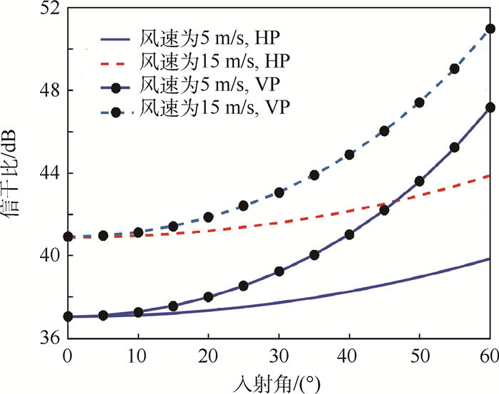
图 7 海面温度为25 ℃,海洋盐度为25 psu时,信干比随信号入射角的变化
Figure 7. Changing trend of signal-to-interference ratiowith incident angle of signal when sea surfacetemperature is 25 ℃ and SSS is 25 psu

图 8 多普勒频率范围为[-3, 3] kHz,最大时延为5 chips时,水平极化、垂直极化信号的观测量及其灵敏度与亮温校正量的关系
Figure 8. Relationship of observable and its sensitivity with brightness temperature variation for horizontal and verticalpolarization signal when Doppler frequency range is[-3, 3] kHz and maximal delay is 5 chips

图 9 入射角为30°,多普勒频率范围为[-1, 1] kHz时,水平极化、垂直极化信号观测量对亮温校正量的灵敏度与空间分辨率的关系
Figure 9. Relationship between sensitivity of horizontaland vertical polarization signal observable to brightnesstemperature variation and spatial resolutionwhen incident angle is 30° and Doppler frequencyrange is[-1, 1] kHz
-
[1] 刘良明.卫星海洋遥感导航[M].武汉:武汉大学出版社, 2010:265-266.LIU L M.An introduction to satellite oceanic remote sensing[M].Wuhan:Wuhan University Press, 2010:265-266(in Chinese). [2] FONT J, LAGERLOEF G S E, VINE D M L, et al.The determination of surface salinity with the European SMOS space mission[J].IEEE Transactions on Geoscience & Remote Sensing, 2004, 42(10):2196-2205. https://www.researchgate.net/publication/4063971_The_determination_of_surface_salinity_with_SMOS_-_recent_results_and_main_issues [3] VINE D M L, LAGERLOEF G S E, COLOMB F R, et al.Aquarius:An instrument to monitor sea surface salinity from space[J].IEEE Transactions on Geoscience & Remote Sensing, 2007, 45(7):2040-2050. https://aquarius.nasa.gov/pdfs/Aquarius_LeVine_et_al_2007.pdf [4] LAGERLOEF G S E, SWIFT C T, LEVINE D M.Sea surface salinity:The next remote sensing challenge[J].Oceanography, 1995, 8(2):40-50. https://ntrs.nasa.gov/archive/nasa/casi.ntrs.nasa.gov/19970001845.pdf [5] VALLLLOSSERA M.Determination of sea surface salinity and wind speed by L-band microwave radiometry from a fixed platform[J].International Journal of Remote Sensing, 2004, 25(1):111-128. doi: 10.1080/0143116031000115175 [6] MARCHAN-HERNANDEZ J F, VALENCIA E, RODRIGUEZ-ALVAREZ N, et al.Sea-state determination using GNSS-R data[J].IEEE Geoscience & Remote Sensing Letters, 2010, 7(4):621-625. http://www.academia.edu/4472509/Sea-State_Determination_Using_GNSS-R_Data [7] FABRA F, CARDELLACH E, RIUS A, et al.Phase altimetry with dual polarization GNSS-R over sea ice[J].IEEE Transactions on Geoscience & Remote Sensing, 2012, 50(6):2112-2121. https://www.researchgate.net/profile/Estel_Cardellach/publication/224266079_Phase_altimetry_with_dual_polarization_GNSS-R_over_sea_ice/links/00b7d537dce3aac591000000.pdf [8] RODRIGUEZALVAREZ N, BOSCHLLUIS X, CAMPS A, et al.Soil moisture retrieval using GNSS-R techniques:Experimental results over a bare soil field[J].IEEE Transactions on Geoscience & Remote Sensing, 2009, 47(11):3616-3624. http://ieeexplore.ieee.org/document/5282600/ [9] SOLAT F. Sea surface remote sensing with GNSS and sunlight reflections[D]. Catalunya: Universitat Politécnica de Catalunya, 2003: 149-164. [10] 佟晓林. 提高卫星微波遥感海面盐度反演精度的方法研究[D]. 武汉: 华中科技大学, 2015: 121-127. http://cdmd.cnki.com.cn/Article/CDMD-10487-1015596946.htmTONG X L. Research on improving accuracy methods of ocean surface salinity in satellite microwave remote sensing[D]. Wuhan: Huazhong University of Science and Technology, 2015: 121-127(in Chinese). http://cdmd.cnki.com.cn/Article/CDMD-10487-1015596946.htm [11] XAVIER B L, ADRIANO C, ISAAC R P, et al.PAU/RAD:Design and preliminary calibration results of a new L-band pseudo-correlation radiometer concept[J].Sensors, 2008, 8(7):4392. http://www.mdpi.com/1424-8220/8/7/4392/xml [12] KLEIN L, SWIFT C.An improved model for the dielectric constant of sea water at microwave frequencies[J].IEEE Transactions on Antennas & Propagation, 2003, 25(1):104-111. https://aquarius.umaine.edu/docs/ed_klien_swift_1978.pdf [13] CAMPS A, FONT J, VALL-LLOSSERA M, et al.The WISE 2000 and 2001 field experiments in support of the SMOS mission:Sea surface L-band brightness temperature observations and their application to sea surface salinity retrieval[J].IEEE Transactions on Geoscience & Remote Sensing, 2004, 42(4):804-823. http://ieeexplore.ieee.org/document/1288375/ [14] EL-NIMRI S F. Development of an improved microwave ocean surface emissivity radiative transfer model[D]. Orlando: University of Centeral Florida, 2010: 64-65. https://www.researchgate.net/publication/47714053_DEVELOPMENT_OF_AN_IMPROVED_MICROWAVE_OCEAN_SURFACE_EMISSIVITY_RADIATIVE_TRANSFER_MODEL [15] HEJAZIN Y, JONES W L, SANTOS-GARCIA A, et al.A roughness correction for aquarius sea surface salinity using the CONAE microwave radiometer[J].IEEE Journal of Selected Topics in Applied Earth Observations & Remote Sensing, 2016, 8(12):5500-5510. https://www.researchgate.net/profile/W_Jones/publication/283545603_A_Roughness_Correction_for_Aquarius_Sea_Surface_Salinity_using_the_CONAE_MicroWave_Radiometer/links/5707e07b08aed09e916d1e65.pdf?origin=publication_detail [16] ZAVOROTNY V U, VORONOVICH A G.Scattering of GPS signals from the ocean with wind remote sensing application[J].IEEE Transactions on Geoscience & Remote Sensing, 2002, 38(2):951-964. https://www.esrl.noaa.gov/psd/psd3/multi/remote/pdf/TGARS_2000b.pdf [17] ELFOUHAILY T, CHAPRON B, KATSAROS K, et al.A unified directional spectrum for long and short wind-driven waves[J].Journal of Geophysical Research:Oceans, 1997, 102(C7):15781-15796. doi: 10.1029/97JC00467 [18] CLARIZIA M P, RUF C S.On the spatial resolution of GNSS reflectometry[J].IEEE Geoscience & Remote Sensing Letters, 2016, 13(8):1064-1068. http://adsabs.harvard.edu/abs/2016IGRSL..13.1064C [19] 谢刚.GPS原理与接收机设计[M].北京:电子工业出版社, 2015:242-244.XIE G.Principles of GPS and receiver design[M].Beijing:Publishing House of Electronics Industry, 2015:242-244(in Chinese). -

 下载:
下载:


 点击查看大图

计量
- 文章访问数: 671
- HTML全文浏览量: 115
- PDF下载量: 335
- 被引次数: 0
