


-
摘要:
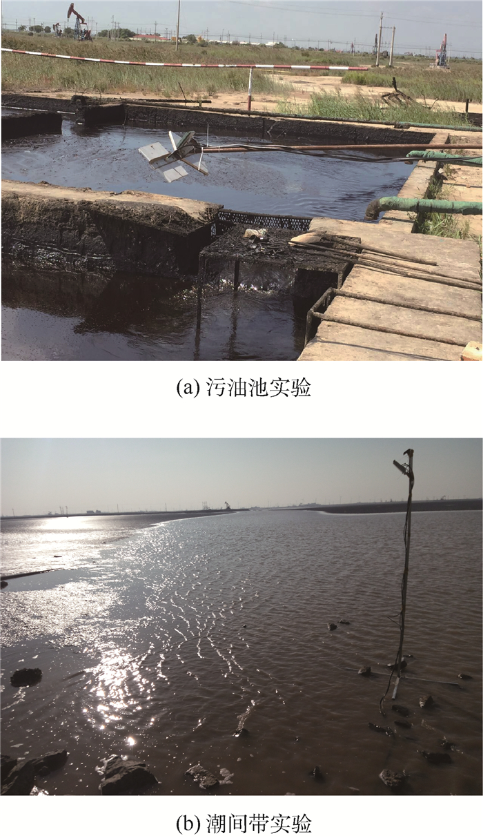
从岸基角度出发,利用全球导航卫星系统反射信号(GNSS-R)技术,同时结合电磁波的部分去极化现象以及反射率与海面粗糙度特征函数的映射关系,建立了三天线观测模式下的海上溢油探测模型,根据反演出目标水域的相对介电常数来判断有无溢油。通过2次实验分别采集污油和潮间带的GNSS直射信号以及反射信号中的左旋、右旋圆极化分量,依据反演模型处理数据并进行了总结与分析。从实验结果来看,当探测表面为油面时反演出的相对介电常数其均值为2.14,标准差为1.44,而海滩在历经潮水的涨落时所反演出相对介电常数值也存在明显的由小增大再减小的过程,油、水反演值差异明显,同时与理论相对介电常数值具有较好的一致性,说明此方法在岸基海上溢油遥感领域具有一定的可行性。
-
关键词:
- 全球导航卫星系统反射信号(GNSS-R) /
- 海上溢油 /
- 岸基平台 /
- 介电常数 /
- 反射率极化比
Abstract:From the perspective of shore-based application, a marine oil spill detection model based on the inversion of the target water's relative dielectric constant was established using the three-antenna global navigation satellite system-reflection (GNSS-R) technology, the partial depolarization phenomenon of the electromagnetic wave, and the mapping relationship between reflectivity and characteristic function of surface roughness. For this purpose, GNSS direct signal, left-hand and right-hand circular polarization components of reflected signals were collected by two field experiments for heavy oil and intertidal zone respectively. After processing the data according to the inversion model, the summary as well as the analysis were carried out. From the experimental results, the mean of retrieved dielectric constant of the oil covered surface is 2.14, its standard deviation is 1.44, and the dielectric constant of the beach has undergone a process of obvious increase and decrease, which is highly consistent with the flood and ebb tide alternates. The difference between oil and water inversion is obvious. The inversion results have a good agreement with the theoretical dielectric constant, which means that this method is feasible for marine oil spill remote sensing in shore-based environment to a certain extent.
-

图 2 石油和海水的圆极化反射系数与卫星高度角的关系
Figure 2. Relationship between reflection coefficient of circular polarization (oil and sea) and satellite elevation

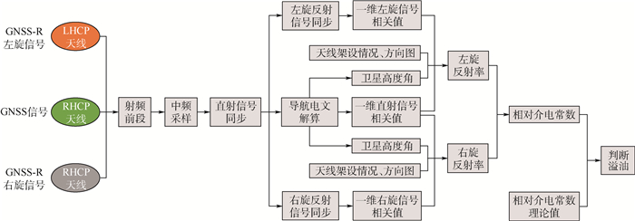
图 3 GNSS直射、反射信号接收处理与海上溢油反演过程
Figure 3. Process of GNSS direct and reflected signals for retrieval of marine oil spill

图 5 污油池实验相对介电常数的反演结果
Figure 5. Inversion results of relative dielectric constant of heavy-oil basin experiment

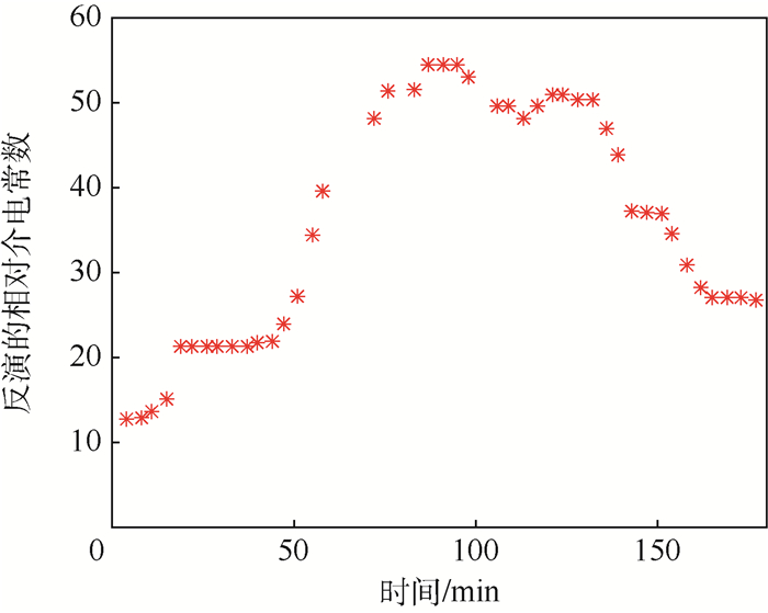
图 6 潮间带实验相对介电常数的反演结果(PRN1)
Figure 6. Inversion results of relative dielectric constant of intertidal zone (PRN1)
表 1 海水和不同油品相对介电常数
Table 1. Relative dielectric constant of sea and different kinds of oil
物质名称 海水 原油 重油 汽油 煤油 柴油 相对介电常数 68~84 2~2.4 2.6~3.0 1.9 2.8 2.1  下载: 导出CSV
表 2 污油池实验反演结果的均值与标准差
Table 2. Mean and standard deviation of inversion results in heavy-oil basin experiment
卫星 均值 标准差 GEO卫星 2.34 1.28 IGSO卫星 2.13 1.70 GEO+IGSO卫星 2.14 1.44
下载: 导出CSV
-
[1] HALL C D, CORDEY R A. Multistatic scatterometry[C]//Preceeding of the IEEE Intemational Geoscience and Remote Sensing Symposium. Piscataway, NJ: IEEE Press, 1988: 561-562. http://ieeexplore.ieee.org/xpls/abs_all.jsp?arnumber=570200 [2] ALONSO-ARROYO A, CAMPS A, PARK H, et al.Retrieval of significant wave height and mean sea surface level using the GNSS-R interference pattern technique:Results from a three-month field campaign[J].IEEE Transactions on Geoscience & Remote Sensing, 2015, 53(6):3198-3209. http://ieeexplore.ieee.org/document/6990586/ [3] RODRIGUEZ-ALVAREZ N, AKOS D M, ZAVOROTNY V U, et al.Airborne GNSS-R wind retrievals using delay-Doppler maps[J].IEEE Transactions on Geoscience & Remote Sensing, 2013, 51(1):626-641. https://www.researchgate.net/profile/Valery_Zavorotny/publication/235953195_Airborne_GNSS-R_wind_retrievals_using_delay-Doppler_maps/links/552d36c20cf2e089a3ad4862.pdf?origin=publication_list [4] CARDELLACH E, FABRA F, NOGUÉS-CORREIG O, et al.GNSS-R ground-based and airborne campaigns for ocean, land, ice, and snow techniques:Application to the GOLD-RTR data sets[J].Radio Science, 2011, 46(6):3604-3629. https://www.researchgate.net/publication/241063186_GNSS-R_ground-based_and_airborne_campaigns_for_ocean_land_ice_and_snow_techniques_Application_to_the_GOLD-RTR_data_sets [5] FABRA F, CARDELLACH E, RIUS A, et al.Phase altimetry with dual polarization GNSS-R over sea ice[J].IEEE Transactions on Geoscience & Remote Sensing, 2012, 50(99):1-10. http://www.academia.edu/10986274/Phase_Altimetry_With_Dual_Polarization_GNSS-R_Over_Sea_Ice [6] SABIA R, CAPARRINI M, RUFFINI G.Potential synergetic use of GNSS-R signals to improve the sea-state correction in the sea surface salinity estimation:Application to the SMOS mission[J].IEEE Transactions on Geoscience & Remote Sensing, 2007, 45(7):2088-2097. https://www.researchgate.net/profile/Giulio_Ruffini/publication/3205404_Potential_Synergetic_Use_of_GNSS-R_Signals_to_Improve_the_Sea-State_Correction_in_the_Sea_Surface_Salinity_Estimation_Application_to_the_SMOS_Mission/links/02bfe510179f526968000000.pdf?inViewer=true&pdfJsDownload=true&disableCoverPage=true&origin=publication_detail [7] JACOBSON M D.Dielectric-covered ground reflectors in GPS multipath reception-Theory and measurement[J].IEEE Geoscience & Remote Sensing Letters, 2008, 5(3):396-399. https://www.researchgate.net/publication/3450044_Dielectric-Covered_Ground_Reflectors_in_GPS_Multipath_Reception-Theory_and_Measurement [8] RODRIGUEZ-ALVAREZ N, BOSCH-LLUIS X, CAMPS A, et al. Soil moisture retrieval using GNSS-R techniques:Experimental results over a bare soil field[J].IEEE Transactions on Geoscience & Remote Sensing, 2009, 47(11):3616-3624. http://ieeexplore.ieee.org/xpl/articleDetails.jsp?arnumber=5282600 [9] JI W, XIU C, LI W, et al. Ocean surface target detection and positioning using the spaceborne GNSS-R delay-Doppler maps[C]//IEEE International Symposium on Geoscience and Remote Sensing. Piscataway, NJ: IEEE Press, 2014: 3806-3809. http://ieeexplore.ieee.org/xpl/articleDetails.jsp?reload=true&arnumber=6947313 [10] 夏威.基于遥感技术的海上溢油应急响应[J].中国水运, 2015(9):20-23. http://d.old.wanfangdata.com.cn/Periodical/zgsy201509005XIA W.Response of marine oil spill emergency based on remote sensing technique[J].China Water Transport, 2015(9):20-23(in Chinese). http://d.old.wanfangdata.com.cn/Periodical/zgsy201509005 [11] VALENCIA E, CAMPS A, MARCHAN-HERNANDEZ J F, et al.Ocean surface's scattering coefficient retrieval by delay-Doppler map inversion[J].IEEE Geoscience & Remote Sensing Letters, 2011, 8(4):750-754. https://www.researchgate.net/publication/220517914_Ocean_Surface's_Scattering_Coefficient_Retrieval_by_Delay-Doppler_Map_Inversion [12] VALENCIA E, CAMPS A, RODRIGUEZ-ALVAREZ N, et al.Using GNSS-R imaging of the ocean surface for oil slick detection[J].IEEE Journal of Selected Topics in Applied Earth Observations & Remote Sensing, 2013, 6(1):217-223. http://ieeexplore.ieee.org/articleDetails.jsp?arnumber=6293919 [13] LI C, HUANG W. Sea surface oil slick detection from GNSS-R delay-Doppler maps using the spatial integration approach[C]//Radar Conference. Piscaway, NJ: IEEE Press, 2013: 1-6. http://ieeexplore.ieee.org/xpls/abs_all.jsp?arnumber=6585990 [14] PARK H, VALENCIA E, RODRIGUEZ-ALVAREZ N, et al. New approach to sea surface wind retrieval from GNSS-R measurements[C]//Geoscience and Remote Sensing Symposium. Piscataway, NJ: IEEE Press, 2011: 1469-1472. http://ieeexplore.ieee.org/xpls/icp.jsp?arnumber=6049344 [15] LI C, HUANG W.Simulating GNSS-R delay-Doppler map of oil slicked sea surfaces under general scenarios[J].Progress in Electromagnetics Research B, 2013, 48(48):61-76. https://www.researchgate.net/profile/Weimin_Huang/publication/270081387_Simulating_GNSS-R_delay-doppler_map_of_oil_slicked_sea_surfaces_under_general_scenarios/links/56acc81008ae19a38513f78b.pdf?inViewer=0&pdfJsDownload=0&origin=publication_detail [16] LI C, HUANG W, GLEASON S.Dual antenna space-based GNSS-R ocean surface mapping:Oil slick and tropical cyclone sensing[J].IEEE Journal of Selected Topics in Applied Earth Observations & Remote Sensing, 2015, 8(1):425-435. http://ieeexplore.ieee.org/xpls/abs_all.jsp?arnumber=6871291 [17] 吴军, 张波, 洪学宝, 等.基于北斗卫星反射信号的海面溢油探测方法及试验[J].北京航空航天大学学报, 2017, 43(1):193-199. http://bhxb.buaa.edu.cn/CN/abstract/abstract13853.shtmlWU J, ZHANG B, HONG X B, et al.Sea surface oil spill detection method using BeiDou satellite reflected signal and its experiment[J].Journal of Beijing University of Aeronautics and Astronautics, 2017, 43(1):193-199(in Chinese). http://bhxb.buaa.edu.cn/CN/abstract/abstract13853.shtml [18] 杨东凯, 张其善.GNSS反射信号处理基础与实践[M].北京:电子工业出版社, 2012:76.YANG D K, ZHANG Q S.GNSS reflected signal processing:Fundamentals and applications[M].Beijing:Publishing House of Electronics Industry, 2012:76(in Chinese). [19] BECKMANN P, SPIZZICHINO A.The scattering of electromagnetic waves from rough surfaces[M].New York:Pergamon Press, 1963:90-200. [20] 文圣常.海浪原理[M].济南:山东人民出版社, 1962:148, 167-172.WEN S C.The principle of the waves[M].Jinan:Shandong People Press, 1962:148, 167-172(in Chinese). [21] LONGUET-HIGGINS M S.On the statistical distribution of the heights of sea waves[J].Journal of Marine Research, 1952, 11:245-266. http://ci.nii.ac.jp/naid/10007974236 [22] 孙孚.三维海浪要素的统计分布[J].中国科学:数学, 1988, 31(5):501-508. http://math.scichina.com:8081/sciA/CN/abstract/abstract374738.shtmlSUN F.Statistical distribution of three dimension ocean wave[J].Science in China:Mathematics, 1988, 31(5):501-508(in Chinese). http://math.scichina.com:8081/sciA/CN/abstract/abstract374738.shtml [23] 罗海清. 基于MSP430的原油含水率测量[D]. 大连: 大连理工大学, 2003: 6-7. http://cdmd.cnki.com.cn/article/cdmd-10141-2003061578.htmLUO H Q. Measurement of water content of oil based on MSP430[D]. Dalian: Dalian University of Technology, 2003: 6-7(in Chinese). http://cdmd.cnki.com.cn/article/cdmd-10141-2003061578.htm -

 下载:
下载:


 点击查看大图
计量
- 文章访问数: 835
- HTML全文浏览量: 137
- PDF下载量: 441
- 被引次数: 0
