


Evaluation of accuracy of shore-based sea surface height inversion based on Beidou satellite reflected signals
-
摘要:
北斗B3I信号作为新一代民用码,相较于北斗B1I信号,具有码速率更高、码片宽度更窄等特点。目前,利用北斗卫星导航系统反射测量(BDS-R)技术对北斗B3I信号进行海面高度反演的研究较少。基于此,在2020年9月7日山东威海附近海域,接收B1I/B3I双频段的直射和反射信号数据,分别采用时延-多普勒(DDM)和载波相位延迟进行岸基海面高度反演。通过实测的同比数据验证反演精度,在信号特性和测高方法2个维度评估北斗B1I和B3I信号海面高度反演的性能。结果显示:采用DDM测高方法,B1I频段和B3I频段的反演结果与实测数据的平均绝对误差和均方根误差分别为1.18 m、1.48 m和0.84 m、1.10 m;采用载波相位延迟测高方法,B1I频段和B3I频段的反演结果与实测数据的平均绝对误差和均方根误差分别为0.12 m、0.15 m和0.10 m、0.12 m。由于信号特性差异,B3I频段的DDM测高结果相较于B1I频段的测高结果精度提高了28%;B3I频段的载波相位延迟测高结果精度略优于B1I频段,两者差异不明显。实验对北斗B1I和B3I信号特性和测高方法导致的反演精度差异的评估,证明了B1I和B3I反射信号均能适用于海面高度反演的需求。
Abstract:Beidou B3I signal, a new generation of civil code, has a higher rate and narrower chip width compared with B1I signal. Currently,there are few studies on the retrieval of sea surface height from B3I signals by using the Beidou reflected signal (BDS-R) technology and no relevant experimental results and accuracy evaluation.This paper usesthe direct and reflected signal data of the B1I/B3I dual band received by the receiver in the sea area near Weihai, Shandong on September 7, 2020, and adopts the delay-Doppler-map (DDM) and carrier phase delay methods respectively to carry out shore-based sea surface height retrieval. The measured data was used to confirm the retrieval’s accuracy, and the performance of the B1I and B3I signals’ sea surface height retrieval was assessed in terms of both their signal characteristics and their height measuring technique.The results show that the mean absolute error/root mean square error of B1I and B3I are 1.18 m/1.48 m and 0.84 m/1.10 m using DDM. The mean absolute error/root mean square error are 0.12 m/0.15 m and 0.10 m/0.12 m respectively using carrier phase delay.Due to the difference in signal characteristics, the accuracy of DDM altimetry B3I is 28% higher than that of B1I, and the accuracy of carrier phase delay altimetry B3I is slightly better than that of B1I, with no obvious difference between the two.Both B1I and B3I reflected signals are demonstrated to be suitable for retrieving sea surface height in this experiment, which compares the differences in retrieval accuracy between B1I and B3I related to signal characteristics and altimetry method.
-
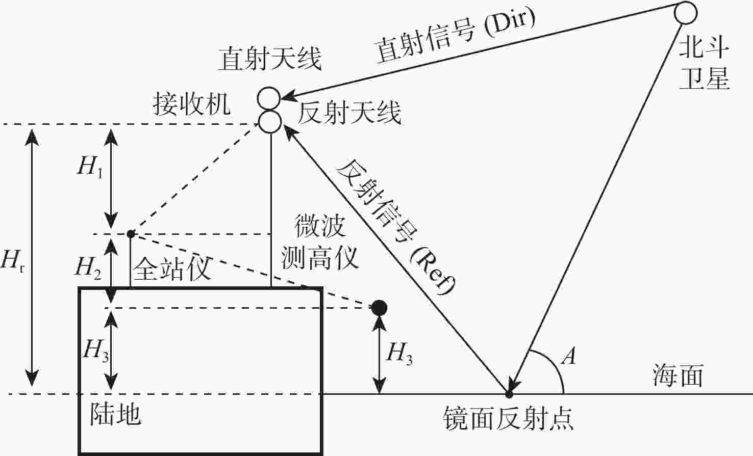
图 1 岸基BDS-R海面高度反演示意图
Figure 1. Schematic diagram of shore-based BDS-R sea surface height retrieval

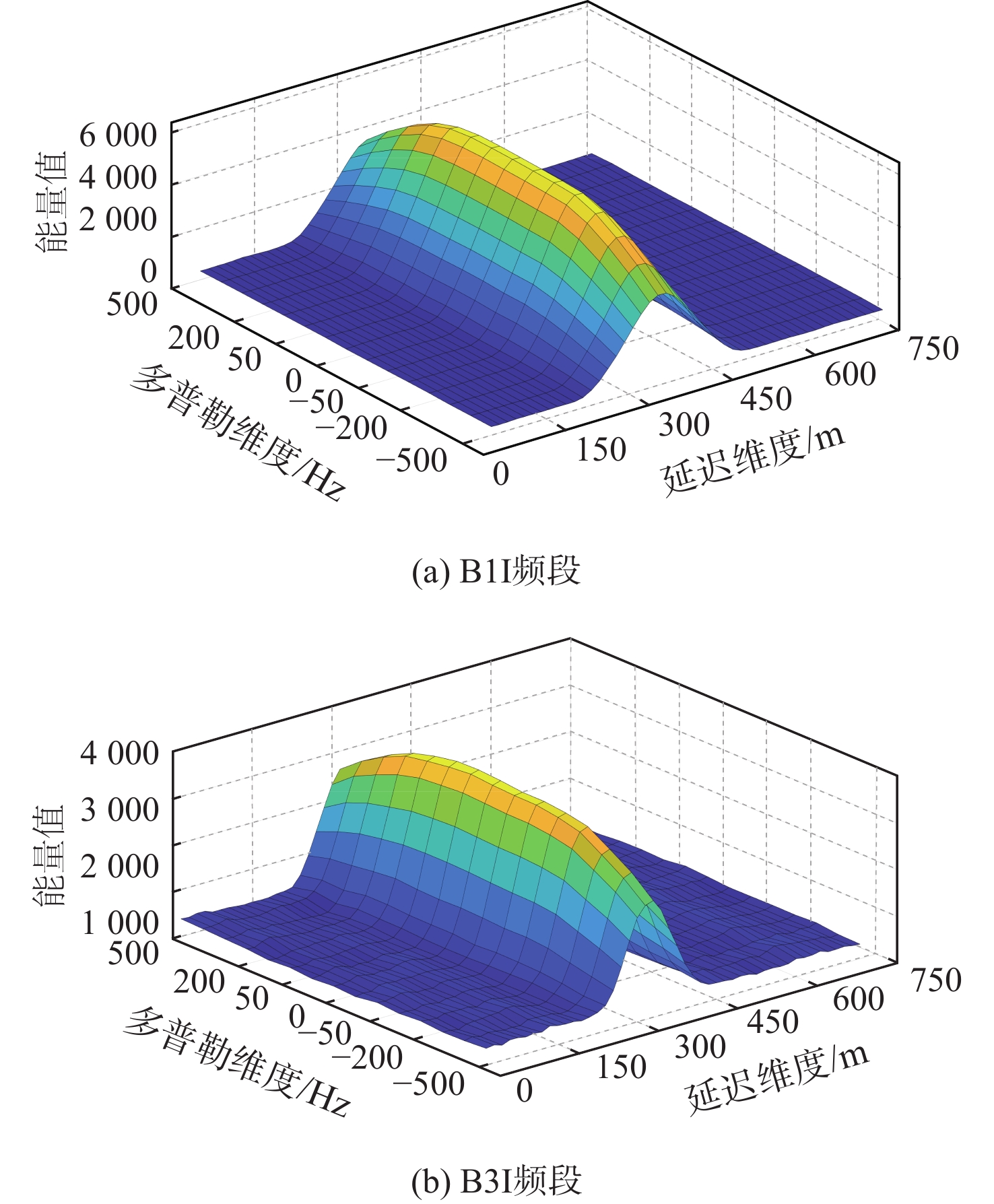
图 2 B1I频段和B3I频段生成的DDM相关功率图
Figure 2. DDM correlation power diagram generated by B1I and B3I frequency bands
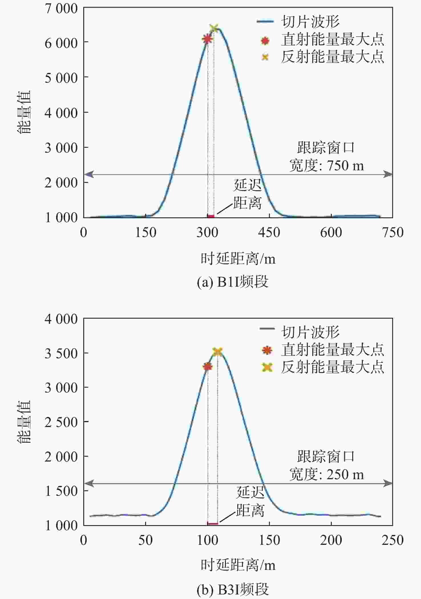
图 3 B1I频段和B3I频段DDM多普勒维度为0的时延一维功率谱切片
Figure 3. Slice of B1I and B3I frequency bands DDM time-delay one-dimensional power spectrum when Doppler is 0

图 4 岸基BDS-R DDM海面高度反演方法流程
Figure 4. Flow chart of shore-based BDS-R DDM sea surface height retrieval method

图 5 B3I频段直射和反射I、Q相关支路波形
Figure 5. Waveforms of I and Q related branches of direct and reflection in B3I frequency band

图 6 B3I频段码延迟和相位延迟对比
Figure 6. Comparison of code delay and phase delay in B3I frequency band
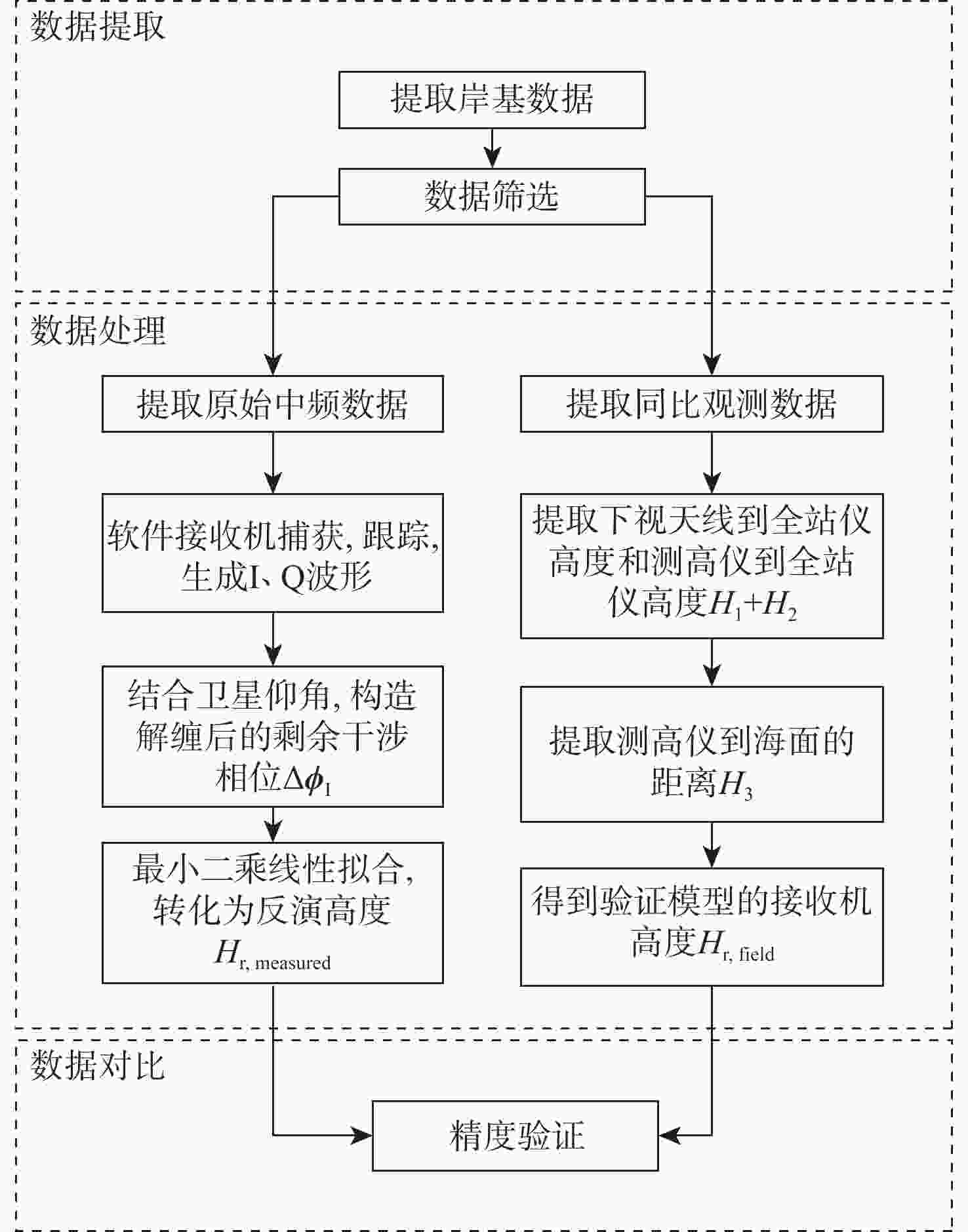
图 7 岸基BDS-R载波相位延迟海面高度反演方法流程
Figure 7. Flow chart of shore-based BDS-R carrier phase delay sea surface height retrieval method

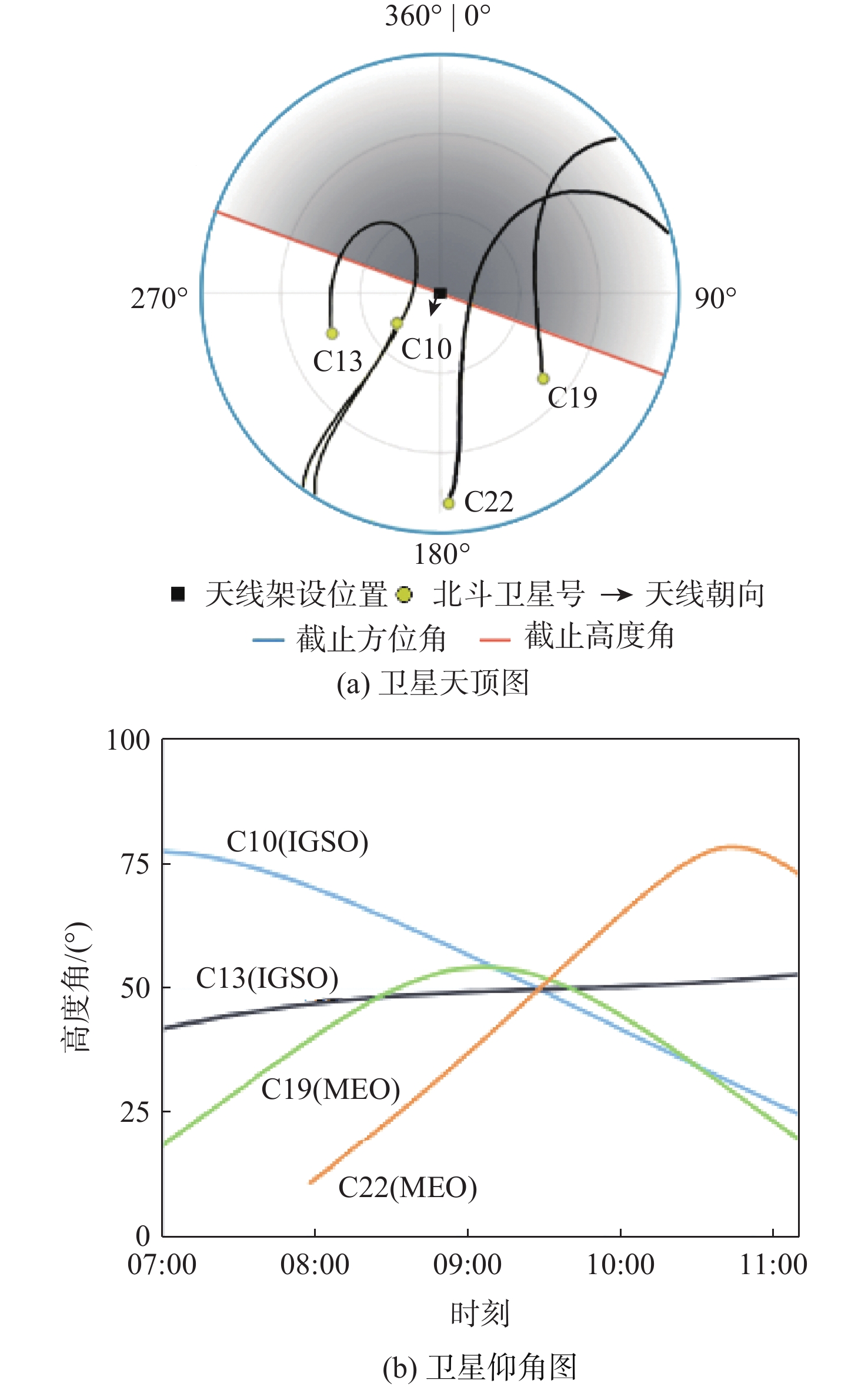
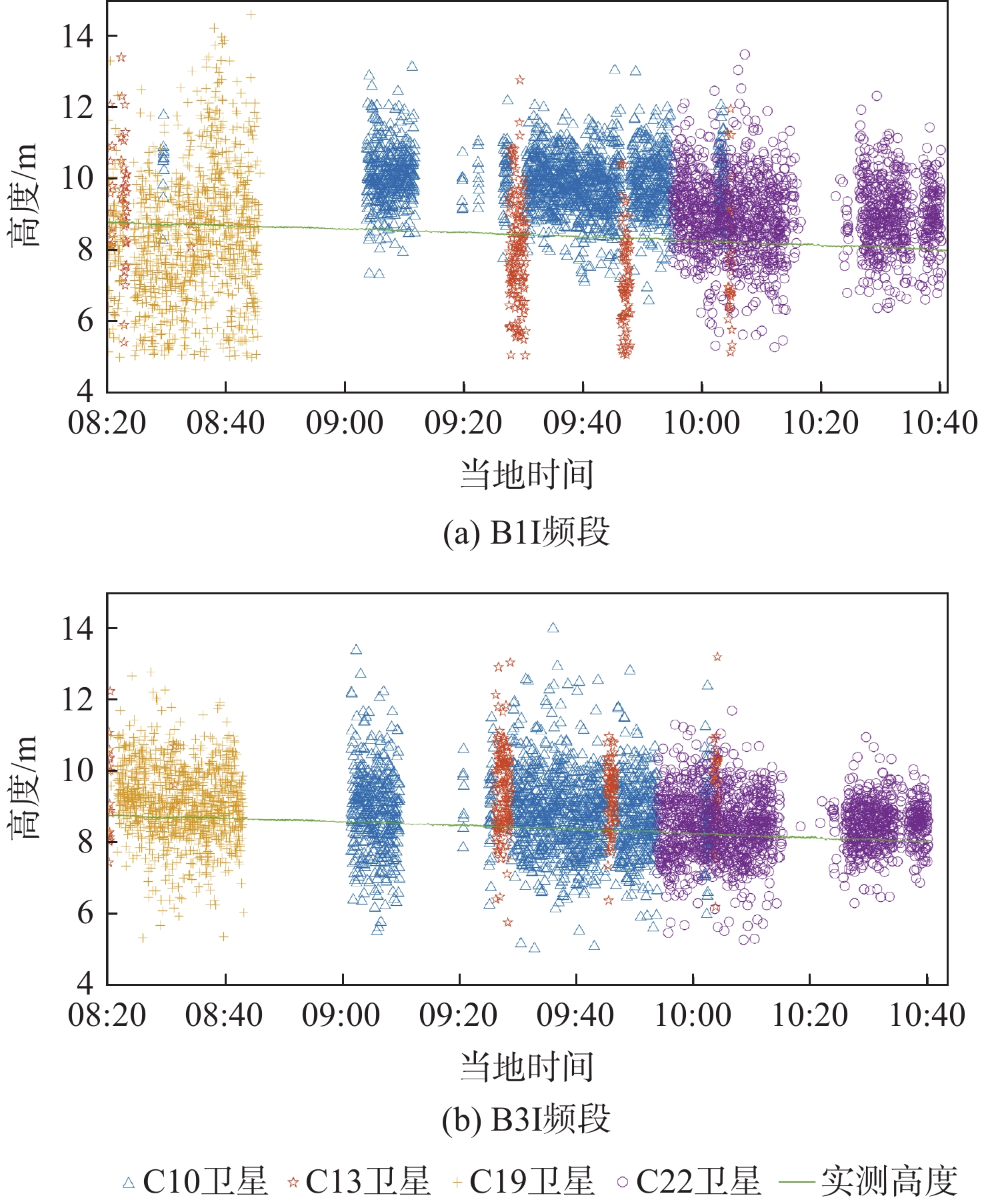
图 11 2020年9月7日08:18—10:41(LT)时刻C10、C13、C19、C22卫星B1I和B3I频段DDM反演与同比数据对比结果
Figure 11. Comparison of B1I and B3I frequency bands DDM retrieval results and measured heights of C10, C13, C19 and C22 satellites at 08:18—10:40 September 7, 2020 (LT)

图 12 2020年9月7日08:55—10:07(LT)时刻B1I和B3I频段载波相位延迟反演与同比数据对比结果
Figure 12. Comparison of B1I and B3I frequency bands carrier phase delay retrieval results and measureed heights at 08:55—10:07 September 7, 2020 (LT)
表 1 北斗B1I和B3I信号对比
Table 1. Comparison of Beidou B1I signals and B3I signals
北斗信号 标称载波频率/MHz 带宽/MHz 波长/m 调制方式 伪码速率/MHz 码片个数 码片宽度/μs 北斗B1I信号 1561.098 4.092 0.192 BPSK 2.046 2046 0.489 北斗B3I信号 1268.52 20.46 0.237 BPSK 10.23 10230 0.098  下载: 导出CSV
表 2 实验相关参数
Table 2. Experimental parameter
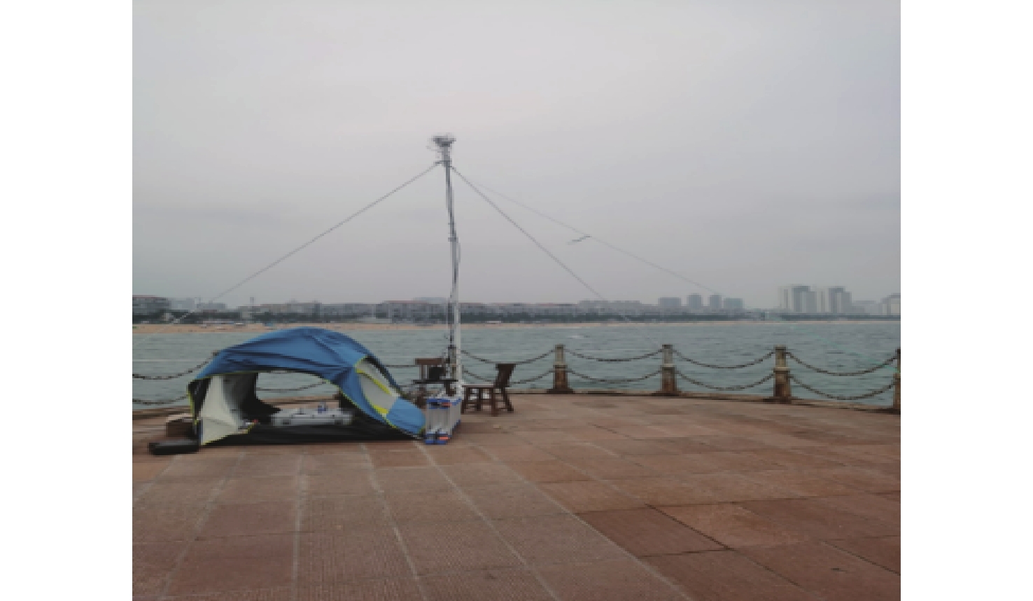
天线架设经纬度 反射天线倾角/(°) 天线架杆长度/m 天线方位角/(°) 直射/反射天线垂直高度差/m 37°32′2.4839″ N,122°2′44.1544″ E 42 5.45 200 0.379
下载: 导出CSV
表 3 实验风速数据
Table 3. Experimental wind speed data
采集时间 风速/(m·s−1) 瞬时风向 08:13 7.1 西北 08:31 7.9 西北 08:50 7 西北 09:11 9.5 西北 09:27 9.8 西北 09:46 8.2 西北 10:00 10.8 西北 10:17 10 西北 10:33 11.7 西北
下载: 导出CSV
表 4 DDM测高方法B1I和B3I频段卫星精度分析
Table 4. DDM height measuring method for B1I and B3I frequency bands accuracy analysis
卫星号 卫星高度角/(°) MAE/m RMSE/m B1I B3I B1I B3I C10 59.1~47.2 1.16 0.88 1.41 1.14 C13 49.3~49.9 1.51 1.02 1.62 1.19 C19 45.9~50.4 1.49 0.84 1.82 1.03 C22 51.0~67.7 0.86 0.71 1.08 0.86 全体数据集 1.18 0.84 1.48 1.10
下载: 导出CSV
表 5 载波相位延迟测高方法B1I和B3I频段卫星精度分析
Table 5. Carrier phase delay height measuring method for B1I and B3I frequency bands accuracy analysis
m 反演频段 卫星号 MAE RMSE B1I 全体数据集 0.12 0.15 B3I 全体数据集 0.10 0.12
下载: 导出CSV
-
[1] 杨元喜. 北斗卫星导航系统的进展、贡献与挑战[J]. 测绘学报, 2010, 39(1): 1-6.YANG Y X. Progress, contribution and challenges of compass/Beidou satellite navigation system[J]. Acta Geodaetica et Cartographica Sinica, 2010, 39(1): 1-6(in Chinese). [2] 邵连军, 张训械, 刘经南, 等. GNSS-R海面测高算法[J]. 海洋测绘, 2010, 30(2): 1-3. doi: 10.3969/j.issn.1671-3044.2010.02.001SHAO L J, ZHANG X X, LIU J N, et al. The algorithm of sea surface altimetry on GNSS-R[J]. Hydrographic Surveying and Charting, 2010, 30(2): 1-3(in Chinese). doi: 10.3969/j.issn.1671-3044.2010.02.001 [3] TREUHAFT R N, LOWE S T, CINZIA Z, et al. 2-cm GPS altimetry over Crater Lake[J]. Geophysical Research Letters, 2001, 22(23): 4343-4346. [4] 白伟华, 孙越强, 朱光武, 等. 利用岸基GNSS-R信号反演湖面高度[C]//第一届中国卫星导航学术年会, 2010: 1646-1652.BAI W H, SUN Y Q, ZHU G W, et al. Lake surface height retrieve using coastal GNSS-R signals[C]//The First China Satellite Navigation Conference, 2010: 1646-1652(in Chinese). [5] RIUS A, CARDELLACH E, MARTÍN-NEIRA M. Altimetric analysis of the sea-surface GPS-reflected signals[J]. IEEE Transactions on Geoscience and Remote Sensing, 2010, 48(4): 2119-2127. doi: 10.1109/TGRS.2009.2036721 [6] ZHANG Y, TIAN L, MENG W, et al. Feasibility of code-level altimetry using coastal BeiDou reflection (BeiDou-R) setups[J]. IEEE Journal of Selected Topics in Applied Earth Observations and Remote Sensing, 2015, 8(8): 4130-4140. doi: 10.1109/JSTARS.2015.2446684 [7] FABRA F, CARDELLACH E, RIUS A, et al. Phase altimetry with dual polarization GNSS-R over sea ice[J]. IEEE Transactions on Geoscience and Remote Sensing, 2012, 50(6): 2112-2121. doi: 10.1109/TGRS.2011.2172797 [8] SEMMLING A M, BEYERLE G, STOSIUS R, et al. Detection of arctic ocean tides using interferometric GNSS-R signals[J]. Geophysical Research Letters, 2011, 38(4): L04103. [9] SEMMLING A M, BEYERLE G, BECKHEINRICH J, et al. Airborne GNSS reflectometry using crossover reference points for carrier phase altimetry[C]//Geoscience & Remote Sensing Symposium. Piscataway: IEEE Press, 2014: 3786-3789. [10] SEMMLING A M, BECKHEINRICH J, WICKERT J, et al. Sea surface topography retrieved from GNSS reflectometry phase data of the GEOHALO flight mission[J]. Geophysical Research Letters, 2014, 41(3): 954-960. doi: 10.1002/2013GL058725 [11] RIUS A, NOGUÉS-CORREIG O, RIBÓ S, et al. Altimetry with GNSS-R interferometry: First proof of concept experiment[J]. GPS Solutions, 2012, 16(2): 231-241. doi: 10.1007/s10291-011-0225-9 [12] CARDELLACH E, RIUS A, MARTIN-NEIRA M, et al. Consolidating the precision of interferometric GNSS-R ocean altimetry using airborne experimental data[J]. IEEE Transactions on Geoscience and Remote Sensing, 2014, 52(8): 4992-5004. doi: 10.1109/TGRS.2013.2286257 [13] ZHANG Y, LI B, TIAN L, et al. Phase altimetry using reflected signals from BeiDou GEO satellites[J]. IEEE Geoscience and Remote Sensing Letters, 2016, 13(10): 1410-1414. doi: 10.1109/LGRS.2016.2578361 [14] 杭斯加, 张云, 李彬彬, 等. 岸基北斗IGSO卫星反射信号相位测高[J]. 遥感信息, 2020, 35(1): 73-81. doi: 10.3969/j.issn.1000-3177.2020.01.009HANG S J, ZHANG Y, LI B B, et al. Feasibility of coastal phase altimetry using BeiDou IGSO satellite reflected signals[J]. Remote Sensing Information, 2020, 35(1): 73-81(in Chinese). doi: 10.3969/j.issn.1000-3177.2020.01.009 [15] 王冬伟, 孙越强, 王先毅, 等. 使用北斗三号B2a反射信号测量水面高度与实验研究[J]. 武汉大学学报(信息科学版), 2022, 47(11): 1878-1886.WANG D W, SUN Y Q, WANG X Y, et al. The water surface altimetry and experiment research using BD-3 B2a reflected signal[J]. Geomatics and Information Science of Wuhan University, 2022, 47(11): 1878-1886(in Chinese). [16] 张云, 张杨阳, 孟婉婷, 等. 机载 GNSS 反射信号海面测高模型的研究[J]. 海洋学报, 2020, 42(3): 149-156.ZHANG Y, ZHANG Y Y, MENG W T, et al. Research on sea surface altimetry model of airborne GNSS reflected signal[J]. Haiyang Xuebao, 2020, 42(3): 149-156(in Chinese). [17] 张云, 马德皓, 孟婉婷, 等. 基于TechDemoSat-1卫星的GPS反射信号海面高度反演的研究[J]. 北京航空航天大学学报, 2021, 47(10): 1941-1948.ZHANG Y, MA D H, MENG W T, et al. Research on sea surface altimetry model of GPS reflected signal based on TechDemoSat-1 satellite[J]. Journal of Beijing University of Aeronautics and Astronautics, 2021, 47(10): 1941-1948(in Chinese). [18] 国家市场监督管理总局, 国家标准化管理委员会. 北斗卫星导航系统公开服务性能规范: GB/T 39473—2020 [S]. 北京: 中国标准出版社, 2020.State Administration for Market Regulation, Standardization Administration of the People’s Republic of China. Specifications for open service performance of BeiDou navigation satellite system: GB/T 39473—2020[S]. Beijing: Standards Press of China, 2020(in Chinese). [19] JIN S, QIAN X, WU X. Sea level change from BeiDou navigation satellite system-reflectometry (BDS-R): First results and evaluation[J]. Global & Planetary Change, 2017, 149: 20-25. [20] GUO J Y, WANG S Y, LIU X, et al. Altimetric algorithm and errors of ocean altimetry using GNSS reflection signals[J]. ChinaOcean Engineering, 2015, 29(6): 933-944. [21] 杨东凯, 张其善. GNSS反射信号处理基础与实践[M]. 北京: 电子工业出版社, 2012∶8-9.YANG D K, ZHANG Q S. GNSS reflected signal processing: Fundamentals and applications[M]. Beijing: Publishing House of Electronics Industry, 2012: 8-9(in Chinese). [22] 张益强, 张其善, 杨东凯, 等. 基于 GPS 遥感的延迟映射接收机关键技术[J]. 北京航空航天大学学报, 2006, 32(3): 333-336. doi: 10.3969/j.issn.1001-5965.2006.03.020ZHANG Y Q, ZHANG Q S, YANG D K, et al. Design of delay mapping receiver for GPS remote sensing[J]. Journal of Beijing University of Aeronautics and Astronautics, 2006, 32(3): 333-336(in Chinese). doi: 10.3969/j.issn.1001-5965.2006.03.020 [23] 郑友淼. BDS-2/BDS-3的MEO卫星B3I频率数据质量对比分析[J]. 北京测绘, 2020, 34(5): 675-678. doi: 10.19580/j.cnki.1007-3000.2020.05.020ZHENG Y M. Comparative analysis of BIOI frequency data quality of MEO satellite based on BDS-2/BDS-3[J]. Beijing Surveying and Mapping, 2020, 34(5): 675-678(in Chinese). doi: 10.19580/j.cnki.1007-3000.2020.05.020 -

 下载:
下载:


 点击查看大图

计量
- 文章访问数: 294
- HTML全文浏览量: 59
- PDF下载量: 90
- 被引次数: 0
