| Citation: | HUYAN Jiayue, XU Lijun, LI Xiaoluet al. Three-dimensional point cloud registration technique for self-designed LiDAR[J]. Journal of Beijing University of Aeronautics and Astronautics, 2019, 45(10): 2099-2107. doi: 10.13700/j.bh.1001-5965.2019.0014(in Chinese)

|
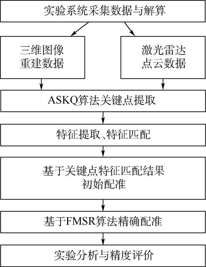
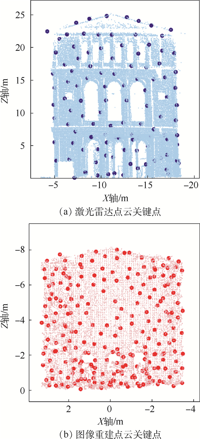
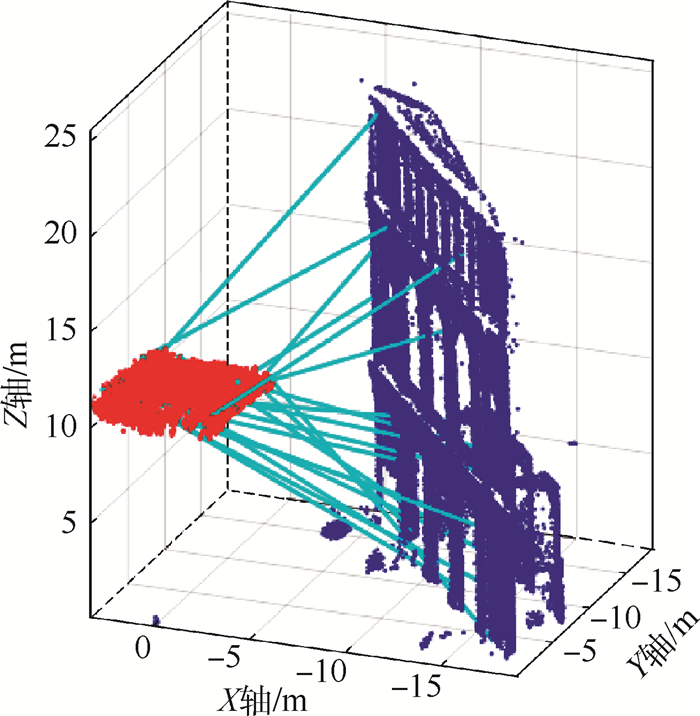
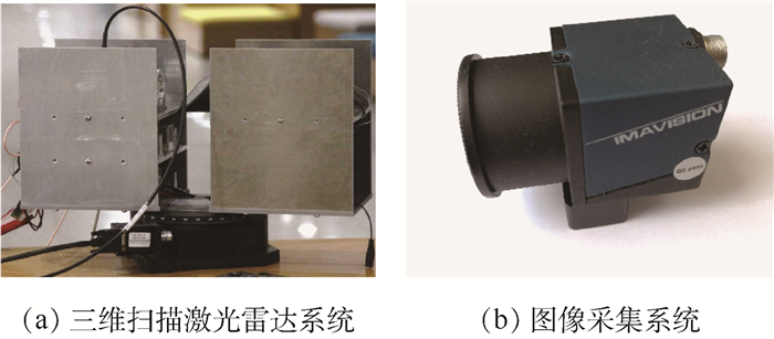
In order to realize the registration of point cloud data respectively obtained from LiDAR and camera, we used a fast multi-scale registration (FMSR) algorithm to register the point cloud data, based on a self-designed three-dimensional scanning laser radar system in our laboratory. The algorithm includes two steps:coarse registration and fine registration. In the coarse registration, an adaptive scale key point quality (ASKQ) algorithm was used to match key points and determine the initial parameters for fine registration. And in the fine registration, K-nearest neighbors (KNN) algorithm was used to simplify the search process and improve the algorithm efficiency. The optimal rotation matrix, translation vector and scale factor between two sets of point cloud data were obtained through many iterations. The simulation verified the stability of FMSR algorithm for multiscale registration. Simulation and experimental results show that the proposed algorithm successfully registers the point cloud data of the self-made LiDAR system and commercial camera. The root-mean-square error of the registration is 0.194 m and the execution time is 16.207 s, for a building with size of 20.30 m×7.85 m×26.56 m. Compared with an existing scale-iterative closest point (S-ICP) algorithm, the registration accuracy of the proposed algorithm is improved by 0.131 m, and the execution time is reduced by 30%. The proposed point cloud registration method can provide an algorithm basis for scene reconstruction and texture matching.

| [1] |
骆社周, 习晓环, 王成.激光雷达遥感在文化遗产保护中的应用[J].遥感技术与应用, 2014, 29(6):1054-1059. http://d.old.wanfangdata.com.cn/Periodical/ygjsyyy201406021
LUO S Z, XI X H, WANG C.The application of LiDAR remote sensing of cultural heritage preservation[J].Remote Sensing Technology and Application, 2014, 29(6):1054-1059(in Chinese). http://d.old.wanfangdata.com.cn/Periodical/ygjsyyy201406021
|
| [2] |
赵一鸣, 李艳华, 商雅楠, 等.激光雷达的应用及发展趋势[J].遥测遥控, 2014, 35(5):4-22. doi: 10.3969/j.issn.2095-1000.2014.05.002
ZHAO Y M, LI Y H, SHANG Y N, et al.Application and development direction of LiDAR[J].Journal of Telemetry, Tracking and Command, 2014, 35(5):4-22(in Chinese). doi: 10.3969/j.issn.2095-1000.2014.05.002
|
| [3] |
曾齐红.机载激光雷达点云数据处理与建筑物三维重建[D].上海: 上海大学, 2009. http://cdmd.cnki.com.cn/Article/CDMD-11903-2009252698.htm
ZENG Q H.Airborne LiDAR point cloud data processing and 3D building reconstruction[D]. Shanghai: Shanghai University, 2009(in Chinese). http://cdmd.cnki.com.cn/Article/CDMD-11903-2009252698.htm
|
| [4] |
YANG M D, CHAO C F, HUANG K S, et al.Image-based 3D scene reconstruction and exploration in augmented reality[J]. Automation in Construction, 2013, 33:48-60. doi: 10.1016/j.autcon.2012.09.017
|
| [5] |
WANG R.3D building modeling using images and LiDAR:A review[J].International Journal of Image and Data Fusion, 2013, 4(4):273-292. doi: 10.1080/19479832.2013.811124
|
| [6] |
ABAYOWA B O, YILMAZ A, HARDIE R C.Automatic registration of optical aerial imagery to a LiDAR point cloud for generation of city models[J].ISPRS Journal of Photogrammetry and Remote Sensing, 2015, 106:68-81. doi: 10.1016/j.isprsjprs.2015.05.006
|
| [7] |
王欣, 张明明, 于晓, 等.应用改进迭代最近点方法的点云数据配准[J].光学精密工程, 2012, 20(9):2068-2077. http://d.old.wanfangdata.com.cn/Periodical/gxjmgc201209026
WANG X, ZHANG M M, YU X, et al.Point cloud registration based on improved iterative closest point method[J].Optics and Precision Engineering, 2012, 20(9):2068-2077(in Chinese). http://d.old.wanfangdata.com.cn/Periodical/gxjmgc201209026
|
| [8] |
BESL P J, MCKAY N D.A method for registration of 3-D shapes[J].Proceedings of SPIE-The International Society for Optical Engineering, 1992, 14(3):239-256. http://cn.bing.com/academic/profile?id=8cbd56d19370d28b22837979c6fb8d92&encoded=0&v=paper_preview&mkt=zh-cn
|
| [9] |
YING S, PENG J, DU S, et al.A scale stretch method based on ICP for 3D data registration[J].IEEE Transactions on Automation Science and Engineering, 2009, 6(3):559-565. doi: 10.1109/TASE.2009.2021337
|
| [10] |
CHEN Y, MEDIONI G.Object modelling by registration of multiple range images[J].Image and Vision Computing, 1992, 10(3):145-155. doi: 10.1016/0262-8856(92)90066-C
|
| [11] |
RUSINKIEWICZ S, LEVOY M.Efficient variants of the ICP algorithm[C]//Proceedings 3rd International Conference on 3-D Digital Imaging and Modeling.Piscataway, NJ: IEEE Press, 2001: 145-152.
|
| [12] |
戴静兰, 陈志杨, 叶修梓.ICP算法在点云配准中的应用[J].中国图象图形学报, 2007, 12(3):517-521. doi: 10.3969/j.issn.1006-8961.2007.03.023
DAI J L, CHEN Z Y, YE X Z.The application of ICP algorithm in point cloud alignment[J].Journal of Image and Graphics, 2007, 12(3):517-521(in Chinese). doi: 10.3969/j.issn.1006-8961.2007.03.023
|
| [13] |
邹际祥.基于KD-tree加速的点云数据配准技术研究[D].合肥: 安徽大学, 2013. http://cdmd.cnki.com.cn/Article/CDMD-10357-1013258892.htm
ZOU J X.The research of point cloud data registration technique based on KD-tree acceleration[D].Hefei: Anhui University, 2013(in Chinese). http://cdmd.cnki.com.cn/Article/CDMD-10357-1013258892.htm
|
| [14] |
MIAN A, BENNAMOUN M, OWENS R.On the repeatability and quality of keypoints for local feature-based 3D object retrieval from cluttered scenes[J].International Journal of Computer Vision, 2010, 89(2-3):348-361. doi: 10.1007/s11263-009-0296-z
|
| [15] |
LI X L, LI Y Y, XU L J.Terrestrial laser scanner autonomous self-calibration with no prior knowledge of point-clouds[J].IEEE Sensors Journal, 2018, 18(22):9277-9285. doi: 10.1109/JSEN.2018.2869559
|
| [16] |
LI X L, LI Y Y, XIE X H, et al.Lab-built terrestrial laser scanner self-calibration using mounting angle error correction[J].Optics Express, 2018, 26(11):14444-14460. doi: 10.1364/OE.26.014444
|
| [17] |
LI X L, YANG B W, XIE X H, et al.Influence of waveform characteristics on LiDAR ranging accuracy and precision[J]. Sensors, 2018, 18(4):1156-1172. doi: 10.3390/s18041156
|
| [18] |
LI X L, WANG H M, YANG B W, et al.Influence of time-pickoff circuit parameters on LiDAR range precision[J]. Sensors, 2017, 17(10):2369-2389. doi: 10.3390/s17102369
|
| [19] |
XU L J, FENG J, LI X L, et al.Automatic registration method for TLS LiDAR data and image-based reconstructed data[J].IEEE Geoscience and Remote Sensing Letters, 2018, 16(3):482-486. http://cn.bing.com/academic/profile?id=a1e664cbbe722c97e4310bcc58d0d757&encoded=0&v=paper_preview&mkt=zh-cn
|
Figures(9) / Tables(2)
Copyright © Journal of Beijing University of Aeronautics and Astronautics
Address: Editorial Department of Journal of Beijing University of Aeronautics and Astronautics, 37 Xueyuan Road, Haidian District, Beijing Post Code: 100191 Email: jbuaa@buaa.edu.cn
Supported by:
Beijing Renhe Information Technology Co., Ltd.


 DownLoad: