| Citation: | WU Di, ZHANG Bo, LI Bowenet al. Modeling of GNSS-R signal under effects of swell and rain[J]. Journal of Beijing University of Aeronautics and Astronautics, 2020, 46(1): 141-149. doi: 10.13700/j.bh.1001-5965.2019.0125(in Chinese)

|
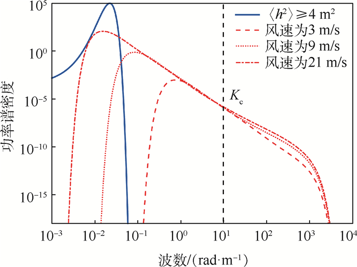
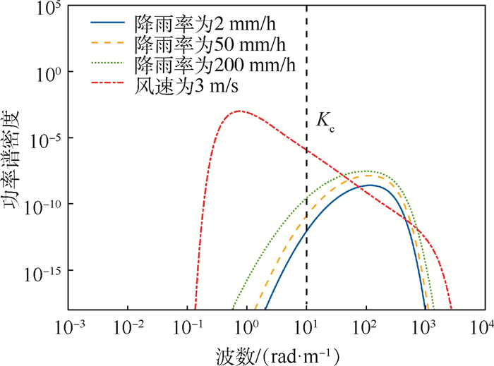
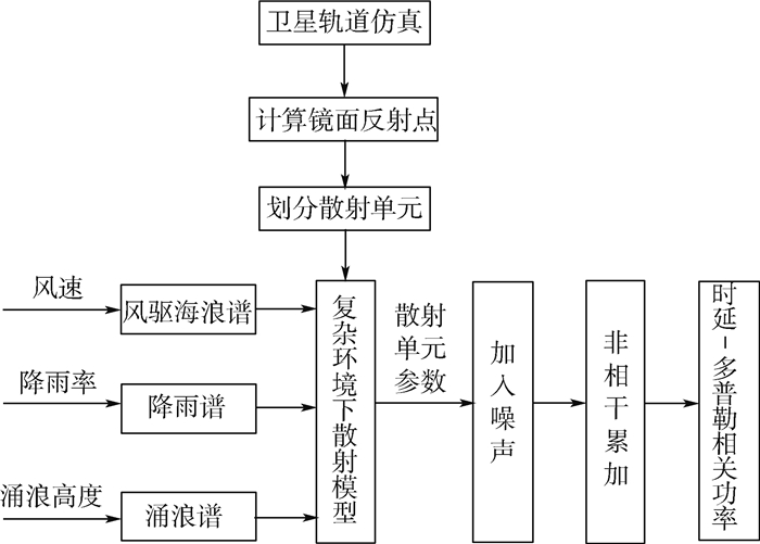
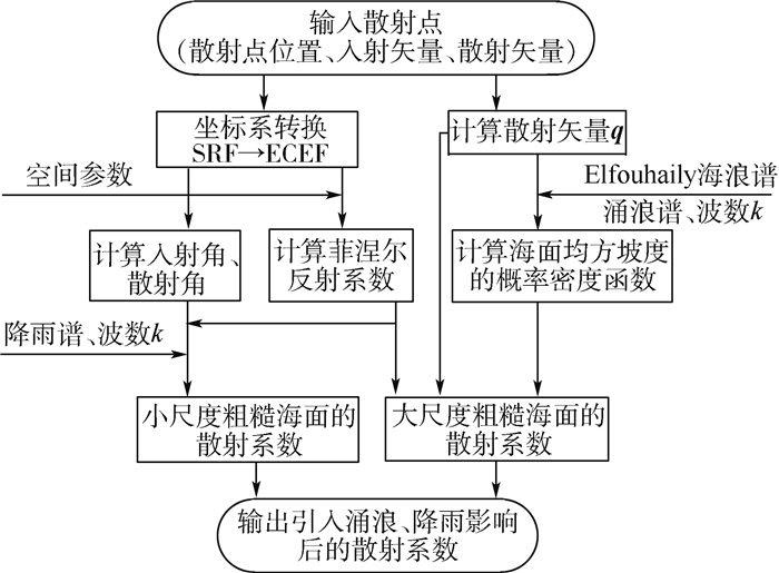
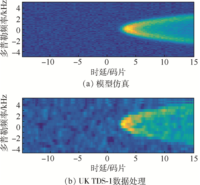
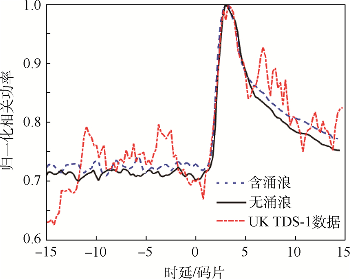
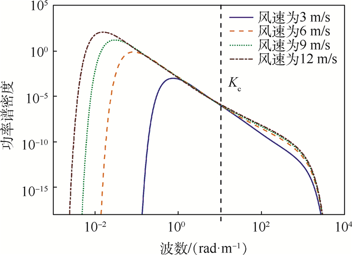
The simulation of global navigation satellite system (GNSS) signal reflected from the ocean surface mostly uses wind-driven wave spectrum, which ignores the effect of swell and rain in real complex environment. For this reason, a model of GNSS signal reflected from the ocean surface under the effect of swell and rain is proposed. First, Elfouhaily spectrum, swell spectrum and rain spectrum are simulated respectively. The effects of swell and rain on GNSS-R signal are analyzed form the perspective of wave spectrum. Then, the method of modeling the GNSS-R signal after introducing the factors of swell and rain is designed. The noise model is established. Finally, the delay-Doppler maps(DDM) and dely waveform(DW) simulated in the spaceborne scenario are analyzed and compared with the results of the UK TDS-1 measured data. The validation results show that the swell mainly forms the large-scale rough sea surface which has great influence on the GNSS-R signal, while the rain has little influence on the GNSS-R signal. The simulated DDM has good consistency with the measured data, and the correlation coefficient between simulated DW and measured data is 0.92, which is better than the comparison result of the uncorrected model. The simulated reflected signal is more real, which proves the feasibility and effectiveness of the proposed GNSS-R signal modeling method. It has certain reference significance and practical value for the modeling of GNSS-R signal in real complex environment and the application of GNSS-R spaceborne detection.

| [1] |
杨东凯, 张其善.GNSS反射信号处理基础与实践[M].北京:电子工业出版社, 2012:7-13.
YANG D K, ZHANG Q S.GNSS reflected signal processing:Fundamentals and applications[M].Beijing:Publishing House of Electronics Industry, 2012:7-13(in Chinese).
|
| [2] |
LI W Q, RIUS A, FABRA F, et al.Revisiting the GNSS-R waveform statistics and its impact on altimetric retrievals[J].IEEE Transactions on Geoscience and Remote Sensing, 2018, 56(5):1-18. doi: 10.1109/TGRS.2018.2825927
|
| [3] |
WANG F, YANG D K, ZHANG B, et al.Waveform-based spaceborne GNSS-R wind speed observation:Demonstration and analysis using UK TechDemoSat-1 data[J].Advances in Space Research, 2018, 61(6):1573-1587. doi: 10.1016/j.asr.2018.01.013
|
| [4] |
金双根, 张勤耘, 钱晓东.全球导航卫星系统反射测量(GNSS+R)最新进展与应用前景[J].测绘学报, 2017, 46(10):1389-1398. doi: 10.11947/j.AGCS.2017.20170282
JIN S G, ZHANG Q Y, QIAN X D.New progress and application prospects of global navigation satellite system reflectometry(GNSS+R)[J].Acta Geodaetica et Cartographica Sinica, 2017, 46(10):1389-1398(in Chinese). doi: 10.11947/j.AGCS.2017.20170282
|
| [5] |
ISOGUCHI O, IZUMIYAMA T, ICHIKAWA K, et al.Detection of sea surface height and wave height using global navigation satellite system reflectometry(GNSS-R): ATT32-03[R].Tokyo: Japan Geoscience Union, 2018.
|
| [6] |
ZAVOROTNY V, VORONOVICH A.Scattering of GPS signals from the ocean with wind remote sensing application[J].IEEE Transactions on Geoscience and Remote Sensing, 2000, 38(2):951-964. doi: 10.1109/36.841977
|
| [7] |
SCHIAVULLI D, GHAVIDEL A, CAMPS A, et al.A simulator for GNSS-R polarimetric observation over the ocean[C]//2004 IEEE Geoscience and Remote Sensing Symposium.Piscataway, NJ: IEEE Press, 2014: 3802-3805.
|
| [8] |
GHAVIDEL A, SCHIAVULLI D, CAMPS A.Numerical computation of the electromagnetic bias in GNSS-R altimetry[J].IEEE Transcations on Geoscience and Remote Sensing, 2016, 54(1):489-498. doi: 10.1109/TGRS.2015.2460212
|
| [9] |
GHAVIDEL A, CAMPS A.Impact of rain, swell, and surface currents on the electromagnetic bias in GNSS-Reflectometry[J].IEEE Journal of Selected Topics in Applied Earth Observations and Remote Sensing, 2016, 9(10):4643-4649. doi: 10.1109/JSTARS.2016.2538181
|
| [10] |
PARK H, MARCHAN-HERNANDEZ J F, RODRIGUEZ-ALVAREZ N, et al.End-to-end simulator for global navigation satellite system reflectometry space mission[C]//2010 IEEE Geoscience and Remote Sensing Symposium.Piscataway, NJ: IEEE Press, 2010: 4294-4297.
|
| [11] |
PARK H, CAMPS A, PASCUA D, et al.Improvement of the PAU/PARIS end-to-end performance simulator (P2EPS) in prepapation for upcoming GNSS-R missions[C]//2013 IEEE Geoscience and Remote Sensing Symposium.Piscataway, NJ: IEEE Press, 2013: 362-365.
|
| [12] |
PARK H, CAMPS A, PASCUA D, et al.Evolution of PAU/PARIS end-to-end performance simulator (P2EPS) towards GNSS reflectometry, radio occulation and scatterometry simulator(GEROS-SIM)[C]//2015 IEEE Geoscience and Remote Sensing Symposium.Piscataway, NJ: IEEE Press, 2015: 4757-4760.
|
| [13] |
LI B W, ZHANG B, YANG D K, et al.An improved model and simulator design of GNSS ocean reflected signals[C]//2017 Forum on Cooperative Positioning and Service.Piscataway, NJ: IEEE Press, 2017: 157-161.
|
| [14] |
YAN Q Y, HUANG W M.GNSS-R delay-Doppler map simulation based on the 2004 Sumatra-Andaman tsunami event[J].Journal of Sensors, 2016(14):1-14. http://www.wanfangdata.com.cn/details/detail.do?_type=perio&id=f0a506402b3b263a06b37680495d6dae
|
| [15] |
BAI W H, XIA J M, ZHAO D Y, et al.GREEPS: An GNSS-R end-to-end performance simulator[C]//2016 IEEE International Geoscience and Remote Sensing Symposium.Piscataway, NJ: IEEE Press, 2016: 4831-4834.
|
| [16] |
ASGARIMEHR M, WICKERT J, REICH S.TDS-1 GNSS reflectometry:Development and validation of forward scattering winds[J].IEEE Journal of Selected Topics in Applied Earth Observations and Remote Sensing, 2018, 11(11):4534-4541. doi: 10.1109/JSTARS.2018.2873241
|
| [17] |
HWANG P A, PLANT W J.Swell influence on ocean surface roughness and radar scattering from the ocean surface[C]//2009 IEEE International Geoscience and Remote Sensing Symposium.Piscataway, NJ: IEEE Press, 2009: 37-40.
|
| [18] |
ELFOUHAILY T, CHAPRON B, KATSAROS K, et al.A unified directional spectrum for long and short wind-driven waves[J].Journal of Geophysical Research, 1997, 102(C7):15. doi: 10.1029-97JC00467/
|
| [19] |
BROWN G S.Backscattering from a Gaussian-distributed perfectly conducting rough surface[J].IEEE Transactions on Antennas and Propagation, 1978, 26(3):472-482. doi: 10.1109/TAP.1978.1141854
|
| [20] |
李水清, 赵栋梁.风浪和涌浪分离方法的比较[J].海洋学报, 2012, 34(2):23-29. http://d.old.wanfangdata.com.cn/Periodical/hyxb201202003
LI S Q, ZHAO D L.Comparisons on partitioning techniques to identify wind-wave and swell[J].Acta Oceanologica Sinica, 2012, 34(2):23-29(in Chinese). http://d.old.wanfangdata.com.cn/Periodical/hyxb201202003
|
| [21] |
DURDEN S L, VESECKY J F.A physical radar cross-section model for a wind-driven sea with swell[J].IEEE Journal of Oceanic Engineering, 1985, 10(4):445-451. doi: 10.1109/JOE.1985.1145133
|
| [22] |
BLIVEN L F, SOBIESKI P W, CRAEYE C.Rain generated ring-waves:Measurements and modelling for remote sensing[J].International Journal of Remote Sensing, 1997, 18(1):221-228. doi: 10.1080/014311697219385
|
| [23] |
祁永强, 张波, 杨东凯, 等.GNSS海面反射信号的三维建模方法[J].北京航空航天大学学报, 2018, 44(1):125-131. doi: 10.13700/j.bh.1001-5965.2017.0023
QI Y Q, ZHANG B, YANG D K, et al.Three dimensional modeling method of GNSS sea surface reflection signal[J].Journal of Beijing University of Aeronautics and Astronautics, 2018, 44(1):125-131(in Chinese). doi: 10.13700/j.bh.1001-5965.2017.0023
|
| [24] |
PARK H, CAMPS A, PASCUAL D.A generic level 1 simulator for spaceborne GNSS-R missions and application to GEROS-ISS ocean reflectometry[J].IEEE Journal of Selected Topics in Applied Earth Observations and Remote Sensing, 2017, 10(10):4645-4659. doi: 10.1109/JSTARS.2017.2720625
|
| [25] |
PARK H, CAMPS A, VALENCIA E, et al.Retracking considerations in spaceborne GNSS-R altimetry[J].GPS Solutions, 2012, 16(4):507-518. doi: 10.1007/s10291-011-0251-7
|
| [26] |
GLEASON S.Space-based GNSS scatterometry:Ocean wind sensing using an empirically calibrated model[J].IEEE Transactions on Geoscience and Remote Sensing, 2013, 51(9):4853-4863. doi: 10.1109/TGRS.2012.2230401
|
| [27] |
陈冬冬, 戴永久.近五十年我国西北地区降水强度变化特征[J].大气科学, 2009, 33(5):923-935. doi: 10.3878/j.issn.1006-9895.2009.05.04
CHEN D D, DAI Y J.Characteristics of Northwest China rainfall intensity in recent 50 years[J].Chinese Journal of Atmospheric Sciences, 2009, 33(5):923-935(in Chinese). doi: 10.3878/j.issn.1006-9895.2009.05.04
|
Figures(10) / Tables(1)
Copyright © Journal of Beijing University of Aeronautics and Astronautics
Address: Editorial Department of Journal of Beijing University of Aeronautics and Astronautics, 37 Xueyuan Road, Haidian District, Beijing Post Code: 100191 Email: jbuaa@buaa.edu.cn
Supported by:
Beijing Renhe Information Technology Co., Ltd.


 DownLoad: