| Citation: | TAN Jian, WANG Shenghua, GUO Changshunet al. Video formatting method of near-space data for Web scientific visualization[J]. Journal of Beijing University of Aeronautics and Astronautics, 2020, 46(4): 712-723. doi: 10.13700/j.bh.1001-5965.2019.0300(in Chinese)

|
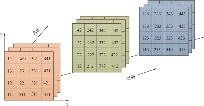
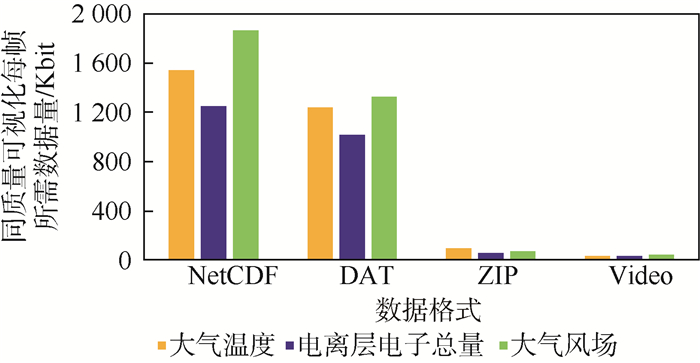
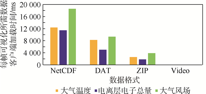
As a transitional region from sky to space, near-space has important value in the fields of science, economy and military. With the development of remote sensing technology and the continuous development of mode simulation, the massive near-space data of higher spatial and temporal resolution is increasing. On the other hand, efficient and convenient Web scientific visualization and information extraction for near-space data are inevitable requirements for the continuous deepening and expansion of near-space data applications. However, the existing data types are cumbersome and the amount of data is huge in near-space, which becomes the key bottleneck of Web transmission and real-time visualization. This paper focuses on the visualization of near-space data on the Web digital globe, and studies it from the point of data organization methods. According to the characteristics of near-space data, combined with the principle of video compression, we propose to decompose, interpolate and color space transform the near-space data to form an image, and then select the appropriate video compression coding method to encode the image into video. Experiment results show that this method can be implemented efficiently. The video organization of spatial data in the Web environment realizes the real-time visualization of near-space data by reducing the amount of data network transmission while ensuring the quality of visualization. The research results in this paper can directly solve the real-time visualization problem of near-space data on Web, provide visual theory and technical support for the near-space science research and knowledge discovery, and provide a reference for the Web scientific visualization on similar massive data.

| [1] |
肖存英, 胡雄, 杨钧烽, 等.临近空间38°N大气密度特性及建模技术[J].北京航空航天大学学报, 2017, 43(9):1757-1765. doi: 10.13700/j.bh.1001-5965.2016.0735
XIAO C Y, HU X, YANG J F, et al.Atmospheric density characteristics and modeling techniques of near space 38°N[J].Journal of Beijing University of Aeronautics and Astronautics, 2017, 43(9):1757-1765(in Chinese). doi: 10.13700/j.bh.1001-5965.2016.0735
|
| [2] |
杨钧烽.中纬度临近空间大气风场变化特性研究[D].北京: 中国科学院国家空间科学中心, 2016.
YANG J F.Study on the variation characteristics of atmospheric wind field in the mid-latitude adjacent space[D].Beijing: National Space Science Center, Chinese Academy of Sciences, 2016(in Chinese).
|
| [3] |
刘涛.临近空间大气风场统计预报方法研究[D].北京: 中国科学院国家空间科学中心, 2017.
LIU T.Research on statistical forecast method for atmospheric wind field in adjacent space[D].Beijing: National Space Science Center, Chinese Academy of Sciences, 2017(in Chinese).
|
| [4] |
邓潘.地基激光雷达对临近空间大气的探测研究[D].合肥: 中国科学技术大学, 2018.
DENG P.Ground-based lidar detection of adjacent space atmosphere[D].Hefei: University of Science and Technology of China, 2018(in Chinese).
|
| [5] |
杨钧烽, 肖存英, 胡雄, 等.临近空间风切变特性及其对飞行器的影响[J].北京航空航天大学学报, 2019, 45(1):57-65. doi: 10.13700/j.bh.1001-5965.2018.0175
YANG J F, XIAO C Y, HU X, et al.Wind shear characteristics of adjacent space and its influence on aircraft[J].Journal of Beijing University of Aeronautics and Astronautics, 2019, 45(1):57-65(in Chinese). doi: 10.13700/j.bh.1001-5965.2018.0175
|
| [6] |
郭文杰.532 nm瑞利多普勒激光雷达若干关键技术和大气重力波观测研究[D].北京: 中国科学院国家空间科学中心, 2016.
GUO W J.Several key technologies of 532 nm Rayleigh Doppler lidar and atmospheric gravity wave observation[D].Beijing: National Space Science Center, Chinese Academy of Sciences, 2016(in Chinese).
|
| [7] |
GOODCHILD M F, GUO H D, ANNONI A, et al.Next-generation digital earth[J].Proceedings of the National Academy of Sciences of the United States of America, 2008, 109(28):11088-11094. http://d.old.wanfangdata.com.cn/Periodical/zgtxtxxb-a199911015
|
| [8] |
LACROUTE P H, LEVOY M.Fast volume rendering using a shear-warp factorization of the viewing transformation[M].New York:ACM, 1994:451-458.
|
| [9] |
LEVOY M.Display of surfaces from volume data[J].IEEE Computer Graphics and Applications, 1988, 8(3):29-37. http://www.wanfangdata.com.cn/details/detail.do?_type=perio&id=e445047350d0f48aabe2c871e72ad683
|
| [10] |
SUN X J, SHEN S H, LEPTOUKH G G, et al.Development of a Web-based visualization platform for climate research using Google Earth[J].Computers & Geosciences, 2012, 47:160-168. http://www.wanfangdata.com.cn/details/detail.do?_type=perio&id=cfb2e0db8e89ee1e1cecc3500f4984b2
|
| [11] |
吴玲达, 于荣欢, 瞿师.大规模三维标量场并行可视化技术综述[J].系统仿真学报, 2012, 24(1):12-16. http://d.old.wanfangdata.com.cn/Conference/7571335
WU L D, YU R H, QU S.Review of large-scale 3D scalar field parallel visualization technology[J].Journal of System Simulation, 2012, 24(1):12-16(in Chinese). http://d.old.wanfangdata.com.cn/Conference/7571335
|
| [12] |
谢衍新, 吴小成, 胡雄, 等.临近空间全球温度场三维变分同化[J].红外与激光工程, 2017, 46(8):55-60. http://d.old.wanfangdata.com.cn/Periodical/hwyjggc201708009
XIE Y X, WU X C, HU X, et al.Three-dimensional variational assimilation of global temperature field in adjacent space[J].Infrared and Laser Engineering, 2017, 46(8):55-60(in Chinese). http://d.old.wanfangdata.com.cn/Periodical/hwyjggc201708009
|
| [13] |
冯健, 甄卫民, 刘钝.电离层环境对地空信息系统的影响效应[J].装备环境工程, 2017, 14(7):7-11. http://d.old.wanfangdata.com.cn/Periodical/jscxgy201707002
FENG J, ZHAI W M, LIU D.Effect of ionospheric environment on ground-air information system[J].Equipment Environmental Engineering, 2017, 14(7):7-11(in Chinese). http://d.old.wanfangdata.com.cn/Periodical/jscxgy201707002
|
| [14] |
王文涛.非结构化网格分片线性矢量场高效可视化技术研究[D].长沙: 国防科学技术大学, 2016.
WANG W T.Research on efficient visualization technology of unstructured grid segmentation linear vector field[D].Changsha: National University of Defense Technology, 2016(in Chinese).
|
| [15] |
曹柱.基于GPU的海洋水体环境多维可视化技术研究[D].青岛: 中国海洋大学, 2015.
CAO Z.GPU-based multi-dimensional visualization technology of marine water environment[D].Qingdao: Ocean University of China, 2015(in Chinese).
|
| [16] |
SUN M, LI J, YANG C W, et al.A Web-based geovisual analytical system for climate studies[J].Future Internet, 2012, 4(4):1069-1085. http://d.old.wanfangdata.com.cn/OAPaper/oai_doaj-articles_8d19d557f02f388621439e8681072be0
|
| [17] |
SARTHOU A, MAS S, JACQUIN M, et al.EarthScape, a multi-purpose interactive 3D globe viewer for hybrid data visualization and analysis[J].The International Archives of Photogrammetry, Remote Sensing and Spatial Information Sciences, 2015, 40(3):487-493. http://www.wanfangdata.com.cn/details/detail.do?_type=perio&id=Doaj000003949526
|
| [18] |
LI W W, SONG M M, ZHOU B, et al.Performance improvement techniques for geospatial Web services in a cyberinfrastructure environment-A case study with a disaster management portal[J].Computers, Environment and Urban Systems, 2015, 54:314-325. http://www.wanfangdata.com.cn/details/detail.do?_type=perio&id=f02ebad90dbf52e1f00b59d69b5d2a8e
|
| [19] |
张凌燕.流媒体服务的OoE计算方法研究[D].北京: 北京邮电大学, 2018.
ZHANG L Y.Research on OoE calculation method of streaming media service[D].Beijing: Beijing University of Posts and Telecommunications, 2018(in Chinese).
|
| [20] |
张志明, 柯卫.基于HTML5的视频通信云服务应用技术研究[J].电信科学, 2012, 28(10):31-37. http://d.old.wanfangdata.com.cn/Periodical/dxkx201210006
ZHANG Z M, KE W.Research on application technology of video communication cloud service based on HTML5[J].Telecommunications Science, 2012, 28(10):31-37(in Chinese). http://d.old.wanfangdata.com.cn/Periodical/dxkx201210006
|
| [21] |
顾春莲.HTML5中的音频及视频元素对互联网的影响[J].河北省科学院学报, 2011, 28(3):106-108. http://www.wanfangdata.com.cn/details/detail.do?_type=perio&id=hbskxyxb201103025
GU C L.The influence of audio and video elements in HTML5 on the Internet[J].Journal of the Hebei Academy of Sciences, 2011, 28(3):106-108(in Chinese). http://www.wanfangdata.com.cn/details/detail.do?_type=perio&id=hbskxyxb201103025
|
| [22] |
LI W W, WANG S Z.Polarglobe:A Web-wide virtual globe system for visualizing multidimensional, time-varying, big climate data[J].International Journal of Geographical Information Science, 2017, 31(8):1562-1582. http://cn.bing.com/academic/profile?id=245f045818df1d415dbb978aa9f5adec&encoded=0&v=paper_preview&mkt=zh-cn
|
| [23] |
刘鹤丹.科学计算可视化中三维等值曲面构建方法研究[D].沈阳: 东北大学, 2015.
LIU H D.Research on construction method of 3D equivalent surface in scientific computing visualization[D].Shenyang: Northeastern University, 2015(in Chinese).
|
| [24] |
支星, 徐海明.3种再分析资料的高空温度与中国探空温度资料的对比:年平均特征[J].大气科学学报, 2013, 36(1):77-87. http://d.old.wanfangdata.com.cn/Periodical/njqxxyxb201301009
ZHI X, XU H M.Comparison of high altitude temperature and Chinese sounding temperature data of three kinds of reanalysis data:Annual average characteristics[J].Chinese Journal of Atmospheric Sciences, 2013, 36(1):77-87(in Chinese). http://d.old.wanfangdata.com.cn/Periodical/njqxxyxb201301009
|
| [25] |
POYNTON C. Chroma subsampling notation[EB/OL].San Francisco: Morgan Kaufmann, 2003(2018-01-24)[2019-06-01].http://poynton.ca/PDFs/Chroma_subsampling_notation.pdf.
|
| [26] |
王少荣, 陈毅松, 汪国平.数字海洋系统的向量场可视化[J].计算机辅助设计与图形学学报, 2016, 28(12):2114-2119. http://d.old.wanfangdata.com.cn/Periodical/jsjfzsjytxxxb201612010
WANG S R, CHEN Y S, WANG G P.Vector field visualization of digital ocean system[J].Journal of Computer-Aided Design & Computer Graphics, 2016, 28(12):2114-2119(in Chinese). http://d.old.wanfangdata.com.cn/Periodical/jsjfzsjytxxxb201612010
|
| [27] |
李骞, 范茵, 王吉奎.基于粒子追踪的风场可视化方法[J].解放军理工大学学报(自然科学版), 2005, 6(1):89-91. http://d.old.wanfangdata.com.cn/Periodical/jfjlgdxxb200501021
LI Q, FAN Y, WANG J K.Visualization method of wind field based on particle tracking[J].Journal of PLA University of Science and Technology(Natural Science Edition), 2005, 6(1):89-91(in Chinese). http://d.old.wanfangdata.com.cn/Periodical/jfjlgdxxb200501021
|
| [28] |
陈静, 邹成, 黄吴蒙, 等.面向虚拟地球的三维气象场可视化方法[J].武汉大学学报(信息科学版), 2016, 41(12):1563-1569. http://d.old.wanfangdata.com.cn/Periodical/whchkjdxxb201612001
CHEN J, ZOU C, HUANG W M, et al.Visualization of 3D meteorological field for virtual earth[J].Journal of Wuhan University(Information Science Edition), 2016, 41(12):1563-1569(in Chinese). http://d.old.wanfangdata.com.cn/Periodical/whchkjdxxb201612001
|
Figures(15) / Tables(4)
Copyright © Journal of Beijing University of Aeronautics and Astronautics
Address: Editorial Department of Journal of Beijing University of Aeronautics and Astronautics, 37 Xueyuan Road, Haidian District, Beijing Post Code: 100191 Email: jbuaa@buaa.edu.cn
Supported by:
Beijing Renhe Information Technology Co., Ltd.


 DownLoad: