| Citation: | SUN Bo, LIANG Yong, HAN Mutian, et al. A method for GNSS-IR soil moisture inversion based on GPS multi-satellite and triple-frequency data fusion[J]. Journal of Beijing University of Aeronautics and Astronautics, 2020, 46(6): 1089-1096. doi: 10.13700/j.bh.1001-5965.2019.0396(in Chinese)

|
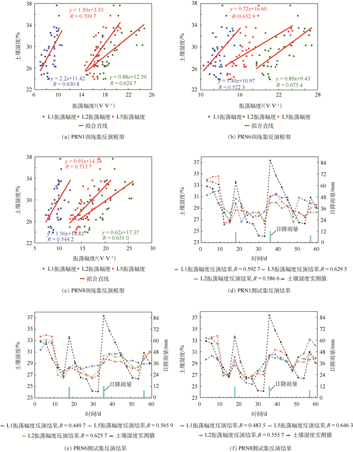
Soil moisture monitoring is one of the key applications of Global Navigation Satellite System Interferometry and Reflectometry (GNSS-IR). Traditional GNSS-IR soil moisture inversion methods generally utilize only one frequency of single satellite, which lose the opportunities of taking full advantages of difference and complementarity of satellite signals with different orbits and frequencies. To solve this problem, this paper proposes a joint inversion method with weighting fusions of the L1, L2 and L5 frequency band data of GPS multi-satellite. In this method, the weighting factor is determined by an adaptive fusion algorithm based on the minimum variance. Field experiment is performed for verification. The results show that, compared with traditional Larson method on the test set, the correlation coefficient and the root-mean-square error of the inversion method proposed in this paper are 24.69% higher and 22.28% lower respectively, and meanwhile compared with the fusion method of the mean value method, the correlation coefficient and the root-mean-square error are 26.77% higher and 23.26% lower respectively. Experimental results prove that the proposed method can effectively improve the inversion accuracy.

| [1] |
袁苇, 李宗谦, 刘宁, 等.不同微波遥感模态和不同数据组合的等湿度区域分布与土壤湿度的反演[J].中国工程科学, 2004, 6(6):50-56. doi: 10.3969/j.issn.1009-1742.2004.06.008
YUAN W, LI Z Q, LIU N, et al.Analysis of data sets with different microwave remote sensing model in soil moisture retrieval[J].Engineering Science, 2004, 6(6):50-56(in Chinese). doi: 10.3969/j.issn.1009-1742.2004.06.008
|
| [2] |
RODRIGUEZ-ALVAREZ N, BOSCH-LLUIS X, CAMPS A, et al.Soil moisture retrieval using GNSS-R techniques:Experimental results over a bare soil field[J].IEEE Transactions on Geoscience and Remote Sensing, 2009, 47(11):3616-3624. doi: 10.1109/TGRS.2009.2030672
|
| [3] |
LARSON K M, SMALL E E, GUTMANN E, et al.Using GPS multipath to measure soil moisture fluctuations:Initial results[J].GPS Solutions, 2008, 12(3):173-177. doi: 10.1007/s10291-007-0076-6
|
| [4] |
SANTAMARÍA-GÓMEZ A, WATSON C, GRAVELLE M, et al.Levelling co-located GNSS and tide gauge stations using GNSS reflectometry[J].Journal of Geodesy, 2015, 89(3):241-258. http://d.old.wanfangdata.com.cn/NSTLQK/NSTL_QKJJ0234466313/
|
| [5] |
CLARIZIA M P, RUF C S, JALES P, et al.Spaceborne GNSS-R minimum variance wind speed estimator[J].IEEE Transactions on Geoscience and Remote Sensing, 2014, 52(11):6829-6843. doi: 10.1109/TGRS.2014.2303831
|
| [6] |
JIN S G, NAJIBI N.Sensing snow height and surface temperature variations in greenland from GPS reflected signals[J].Advances in Space Research, 2014, 53(11):1623-1633. doi: 10.1016/j.asr.2014.03.005
|
| [7] |
LARSON K M, BRAUN J J, SMALL E E, et al.GPS multipath and its relation to near-surface soil moisture content[J].IEEE Journal of Selected Topics in Applied Earth Observations and Remote Sensing, 2010, 3(1):91-99. doi: 10.1109/JSTARS.2009.2033612
|
| [8] |
ROUSSEL N, FRAPPART F, RAMILLIEN G, et al.Detection of soil moisture variations using GPS and GLONASS SNR data for elevation angles ranging from 2° to 70°[J].IEEE Journal of Selected Topics in Applied Earth Observations and Remote Sensing, 2016, 9(10):4781-4794. doi: 10.1109/JSTARS.2016.2537847
|
| [9] |
汉牟田, 张波, 杨东凯, 等.利用GNSS干涉信号振荡幅度反演土壤湿度[J].测绘学报, 2016, 45(11):1293-1300. doi: 10.11947/j.AGCS.2016.20160145
HAN M T, ZHANG B, YANG D K, et al.Soil moisture retrieval utilizing GNSS interference signal amplitude[J].Acta Geodaetica et Cartographica Sinica, 2016, 45(11):1293-1300(in Chinese). doi: 10.11947/j.AGCS.2016.20160145
|
| [10] |
吴继忠, 王天, 吴玮, 等.利用GPS-IR监测土壤含水量的反演模型[J].武汉大学学报信息科学版, 2018, 43(6):887-892. http://d.old.wanfangdata.com.cn/Periodical/whchkjdxxb201806012
WU J Z, WANG T, WU W, et al.Retrieval model for soil moisture content using GPS-interferometric reflectometry[J].Geomatics and Information Science of Wuhan University, 2018, 43(6):887-892(in Chinese). http://d.old.wanfangdata.com.cn/Periodical/whchkjdxxb201806012
|
| [11] |
孙波, 梁勇, 汉牟田, 等.基于GA-SVM的GNSS-IR土壤湿度反演方法[J].北京航空航天大学学报, 2019, 45(3):486-492. doi: 10.13700/j.bh.1001-5965.2018.0417
SUN B, LIANG Y, HAN M T, et al.GNSS-IR soil moisture inversion method based on GA-SVM[J].Journal of Beijing University of Aeronautics and Astronautics, 2019, 45(3):486-492(in Chinese). doi: 10.13700/j.bh.1001-5965.2018.0417
|
| [12] |
ARROYO A A, CAMPS A, AGUASCA A, et al.Dual-polarization GNSS-R interference pattern technique for soil moisture mapping[J].IEEE Journal of Selected Topics in Applied Earth Observations and Remote Sensing, 2014, 7(5):1533-1544. doi: 10.1109/JSTARS.2014.2320792
|
| [13] |
BILICH A, LARSON K M.Correction published 29 March 2008:Mapping the GPS multipath environment using the signal-to-noise ratio(SNR)[J].Radio Science, 2016, 42(6):1-16. doi: 10.1029/2007RS003652
|
| [14] |
CHEW C C, SMALL E E, LARSON K M, et al.An algorithm for soil moisture estimation using GPS-interferometric reflectometry for bare and vegetated soil[J].GPS Solutions, 2016, 20(3):1-13. http://www.wanfangdata.com.cn/details/detail.do?_type=perio&id=dcdf494a3b12864b0900f33f143f1830
|
| [15] |
CHAIR Z, VARSHNEY P K.Optimal data fusion in multiple sensor detection systems[J].IEEE Transactions on Aerospace & Electronic Systems, 2007, 22(1):98-101. doi: 10.1109-TAES.1986.310699/
|
| [16] |
CULP M, MICHAILIDIS G.A co-training algorithm for multi-view data with applications in data fusion[J].Journal of Chemometrics, 2010, 23(6):294-303. http://www.wanfangdata.com.cn/details/detail.do?_type=perio&id=3332b742e8c3d478caa2c1a99299bcfd
|
| [17] |
GHANBARI M, YAZDANPANAH M J.Delay compensation of tilt sensors based on mEMS accelerometer using data fusion technique[J].IEEE Sensors Journal, 2015, 15(3):1959-1966. http://cn.bing.com/academic/profile?id=f991322fce199b8a677bb28bf3c792c0&encoded=0&v=paper_preview&mkt=zh-cn
|

Figures(5) / Tables(1)
Copyright © Journal of Beijing University of Aeronautics and Astronautics
Address: Editorial Department of Journal of Beijing University of Aeronautics and Astronautics, 37 Xueyuan Road, Haidian District, Beijing Post Code: 100191 Email: jbuaa@buaa.edu.cn
Supported by:
Beijing Renhe Information Technology Co., Ltd.


 DownLoad: