| Citation: | JIANG Chenchen, HUO Hongtao, FENG Qiet al. An object-oriented multi-scale segmentation optimization algorithm based on PCA[J]. Journal of Beijing University of Aeronautics and Astronautics, 2020, 46(6): 1192-1203. doi: 10.13700/j.bh.1001-5965.2019.0398(in Chinese)

|
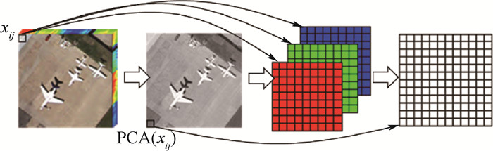
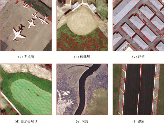
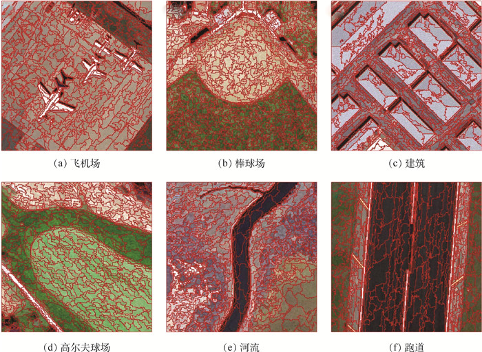
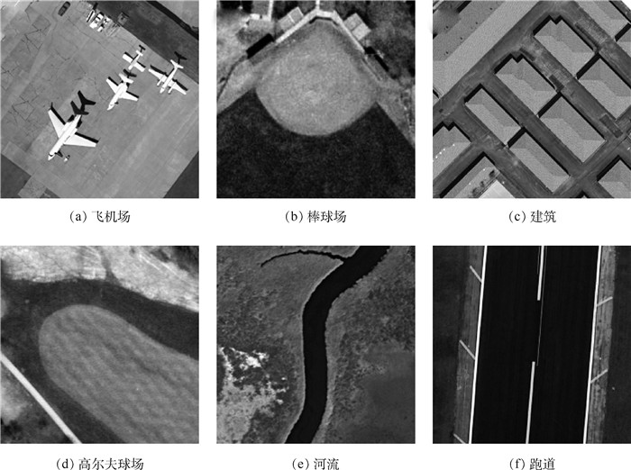
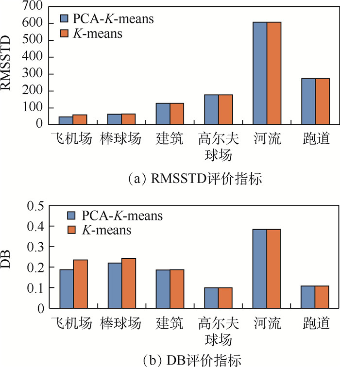
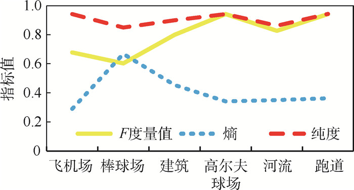
Multi-scale segmentation is the basis of remote sensing images object-oriented classification. The paper proposes an object-oriented multi-scale segmentation optimization algorithm which combines dimension reduction technique with clustering algorithm aiming at the subjectivity of optimal segmentation scale determination of different regional features and the randomness of clustering center determined when using clustering algorithms. In this method, the initial clustering center is generated using the result of dimension reduction and sorting by Principal Component Analysis (PCA). Then the probability of merging each pixel is calculated by

| [1] |
邓书斌.ENVI遥感图像处理方法.[M].2版.北京:高等教育出版社, 2014.
DENG S B.ENVI remote sensing image processing methods[M].2nd ed.Beijing:Higher Education Press, 2014(in Chinese).
|
| [2] |
JOZDANI S E, MOMENI M, JOHNSON B A, et al.A regression modelling approach for optimizing segmentation scale parameters to extract buildings of different sizes[J].International Journal of Remote Sensing, 2018, 39(3):684-703. http://www.wanfangdata.com.cn/details/detail.do?_type=perio&id=10.1080/01431161.2017.1390273
|
| [3] |
HU Z W, ZHANG Q, ZOU Q, et al.Stepwise evolution analysis of the region-merging segmentation for scale parameterization[J].IEEE Journal of Selected Topics in Applied Earth Observations and Remote Sensing, 2018, 11(7):2461-2472.
|
| [4] |
高仁强, 欧阳建, 陈亮雄, 等.面向对象的鹤地水库高分辨率影像分类研究[J/OL].测绘科学: 1-14(2018-11-19)[2019-07-02].http://kns.cnki.net/kcms/detail/11.4415.P.20181115.1629.002.html.
GAO R Q, OU Y J, CHEN L X, et al.Research on high resolution image classification of Hedi reservoir based on object-oriented method[J/OL].Science of Surveying and Mapping: 1-14(2018-11-19)[2019-07-02].http://kns.cnki.net/kcms/detail/11.4415.P.20181115.1629.002.html(in Chinese).
|
| [5] |
HU L, CHAN K C C.Fuzzy clustering in a complex network based on content relevance and link structures[J].IEEE Transactions on Fuzzy Systems, 2016, 24(2):456-470. http://www.wanfangdata.com.cn/details/detail.do?_type=perio&id=f6d62149890d0d2f239d8226d442e278
|
| [6] |
ZHANG H, SHI W Z, HAO M, et al.An adaptive spatially constrained fuzzy c-means algorithm for multispectral remotely sensed imagery clustering[J].International Journal of Remote Sensing, 2018, 39(8):2207-2237. http://www.wanfangdata.com.cn/details/detail.do?_type=perio&id=10.1080/01431161.2017.1420934
|
| [7] |
FAN J C, WANG J.A two-phase fuzzy clustering algorithm based on neurodynamic optimization with its application for PolSAR image segmentation[J].IEEE Transactions on Fuzzy Systems, 2018, 26(1):72-83.
|
| [8] |
王慧贤, 靳惠佳, 王娇龙, 等.k均值聚类引导的遥感影像多尺度分割优化方法[J].测绘学报, 2015, 44(5):526-532. http://d.old.wanfangdata.com.cn/Periodical/chxb201505009
WANG H X, JIN H J, WANG J L, et al.Optimization approach for multi-scale segmentation of remotely sensed imagery under k-means clustering guidance[J].Acta Geodaetica et Cartographica Sinica, 2015, 44(5):526-532(in Chinese). http://d.old.wanfangdata.com.cn/Periodical/chxb201505009
|
| [9] |
SIDDIQUI F U, ISA N A M.Enhanced moving K-means (EMKM) algorithm for image segmentation[J].IEEE Transactions on Consumer Electronics, 2011, 57(2):833-841. http://www.wanfangdata.com.cn/details/detail.do?_type=perio&id=f5787723a74b4461296ad883f8ca04e2
|
| [10] |
姜文斌, 刘丽萍, 孙学宏.基于自适应权重法的K-means模型对遥感图像分割[J].计算机应用与软件, 2019, 36(5):231-234. http://d.old.wanfangdata.com.cn/Periodical/jsjyyyrj201905041
JIANG W B, LIU L P, SUN X H.K-means model based on adaptive weight method for remote sensing image segmentation[J].Computer Applications and Software, 2019, 36(5):231-234(in Chinese). http://d.old.wanfangdata.com.cn/Periodical/jsjyyyrj201905041
|
| [11] |
CHEN S Y, SUN T L, YANG F Q, et al.An improved optimum-path forest clustering algorithm for remote sensing image segmentation[J].Computers & Geosciences, 2018, 112:38-46. http://www.wanfangdata.com.cn/details/detail.do?_type=perio&id=a9ba1323df65bfec0d1433ef4a9dccc9
|
| [12] |
马彩虹, 戴芹, 刘士彬.一种融合PSO和Isodata的遥感图像分割新方法[J].武汉大学学报(信息科学版), 2012, 37(1):35-38. http://d.old.wanfangdata.com.cn/Periodical/whchkjdxxb201201010
MA C H, DAI Q, LIU S B.A new method of remote sensing image segmentation based on PSO and Isodata[J].Geomatics and Information Science of Wuhan University, 2012, 37(1):35-38(in Chinese). http://d.old.wanfangdata.com.cn/Periodical/whchkjdxxb201201010
|
| [13] |
CHEN J Y, ZHENG H B, LIN X, et al.A novel image segmentation method based on fast density clustering algorithm[J].Engineering Applications of Artificial Intelligence, 2018, 73:92-110. http://d.old.wanfangdata.com.cn/OAPaper/oai_doaj-articles_9a8268c3fbd7093f2833dc9bd6e046b8
|
| [14] |
FAN J C, HAN M, WANG J.Single point iterative weighted fuzzy C-means clustering algorithm for remote sensing image segmentation[J].Pattern Recognition, 2009, 42(11):2527-2540. http://www.wanfangdata.com.cn/details/detail.do?_type=perio&id=0bc51794892b8479cdd46a1aea36dd98
|
| [15] |
YANG Y, NEWSAM S.Bag-of-visual-words and spatial extensions for land-use classification[C]//ACM Press the 18th SIGSPATIAL International Conference on Advances in Geographic Information Systems(ACM GIS).New York: ACM, 2010: 270.
|
| [16] |
中国资源卫星应用中心.数据服务平台[EB/OL].(2015-09-02)[2019-07-02].http://www.cresda.com/.
China Centre for Resources Satellite Data and Application.Data service platform[EB/OL].(2015-09-02)[2019-07-02].http://www.cresda.com/(in Chinese).
|
| [17] |
杉山将.图解机器学习[M].许永伟, 译.北京: 人民邮电大学出版社, 2015: 143.
SUGIYAMA M.Graphic machine learning[M].XU Y W, translated.Beijing: People's University of Posts and Telecommunications Press, 2015: 143(in Chinese).
|
| [18] |
JIANG Q C, YAN X F.Parallel PCA-KPCA for nonlinear process monitoring[J].Control Engineering Practice, 2018, 80:17-25. http://www.wanfangdata.com.cn/details/detail.do?_type=perio&id=04f42304818e42208ac070204eeea5d5
|
| [19] |
JAIN A K.Data clustering:50 years beyond K-means[J].Pattern Recognition Letters, 2010, 31(8):651-666. http://d.old.wanfangdata.com.cn/NSTLQK/NSTL_QKJJ0218023812/
|
| [20] |
HARTIGAN J A, WONG M A.Algorithm AS 136:A K-means clustering algorithm[J].Journal of the Royal Statistical Society, 1979, 28(1):100-108. http://d.old.wanfangdata.com.cn/OAPaper/oai_doaj-articles_d9ef8caab2204fcde05264964740e263
|
| [21] |
周本金, 陶以政, 纪斌, 等.最小化误差平方和k-means初始聚类中心优化方法[J].计算机工程与应用, 2018, 54(15):48-52. http://d.old.wanfangdata.com.cn/Periodical/jsjgcyyy201815009
ZHOU B J, TAO Y Z, JI B, et al.Optimizing k-means initial clustering centers by minimizing sum of squared error[J].Computer Engineering and Applications, 2018, 54(15):48-52(in Chinese). http://d.old.wanfangdata.com.cn/Periodical/jsjgcyyy201815009
|
| [22] |
傅立伟, 武森.基于属性值集中度的分类数据聚类有效性内部评价指标[J].工程科学学报, 2019, 41(5):682-693. http://d.old.wanfangdata.com.cn/Periodical/bjkjdxxb201905015
FU L W, WU S.A new internal clustering validation index for categorical data based on concentration of attribute values[J].Chinese Journal of Engineering, 2019, 41(5):682-693(in Chinese). http://d.old.wanfangdata.com.cn/Periodical/bjkjdxxb201905015
|
| [23] |
DAVIES D L, BOULDIN D W.A cluster separation measure[J].IEEE Transactions on Pattern Analysis and Machine Intelligence, 1979, 1(2):224-227. http://d.old.wanfangdata.com.cn/OAPaper/oai_arXiv.org_astro-ph%2f0306174
|
| [24] |
LI M, DE BEURS K M, STEIN A, et al.Incorporating open source data for Bayesian classification of urban land use from vhr stereo images[J].IEEE Journal of Selected Topics in Applied Earth Observations and Remote Sensing, 2017, 10(11):4930-4943. http://www.wanfangdata.com.cn/details/detail.do?_type=perio&id=54a578fe3d41046446e344a40267fa05
|
| [25] |
CHEN Y Y, MING D P, XU L, et al.An overview of quantitative experimental methods for segmentation evaluation of high spatial remote sensing images[J].Journal of Geo-information Science, 2017, 19(6):818-830. http://www.wanfangdata.com.cn/details/detail.do?_type=perio&id=dqxxkx201706011
|

Figures(19) / Tables(3)
Copyright © Journal of Beijing University of Aeronautics and Astronautics
Address: Editorial Department of Journal of Beijing University of Aeronautics and Astronautics, 37 Xueyuan Road, Haidian District, Beijing Post Code: 100191 Email: jbuaa@buaa.edu.cn
Supported by:
Beijing Renhe Information Technology Co., Ltd.


 DownLoad: