| Citation: | TIAN Qiuning, CAO Yueling, HU Xiaogong, et al. Accuracy evaluation of wide-area differential service for BDS-3[J]. Journal of Beijing University of Aeronautics and Astronautics, 2021, 47(5): 967-976. doi: 10.13700/j.bh.1001-5965.2020.0108(in Chinese)

|
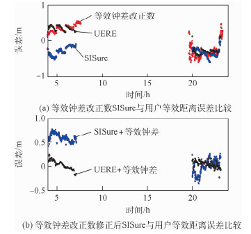
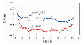
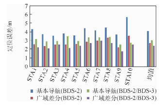
In order to ensure the smooth transition of the wide-area differential service of the Beidou system, the Beidou-3 System (BDS-3) uses D2 navigation message on GEO satellite to broadcast the equivalent clock correction and ionospheric grid information on B1I/B3I frequency. This paper analyzes the characteristics of the equivalent clock correction and ionospheric grid information after adding the BDS-3 satellite, and compares the User Differential Range Error (UDRE) of satellite between the BDS-2 and the BDS-3. Combined with the measured data of BDS-2 and BDS-3, this paper also evaluates the positioning accuracy of wide-area differential service of BDS-3. The analysis results show that, after using the equivalent clock correction, the User Equivalent Range Error (UERE) of the BDS-2 satellite changes from approximately 1 meter to approximately 0.3 meters, while the BDS-3 satellite UERE changes from approximately 0.4 meters to approximately 0.2 meters. The results show that the equivalent clock correction can correct the space signal step error brought by the update of the broadcast message, and significantly improve the satellite space signal accuracy. Compared with the Klobuchar 8 model broadcast by the basic navigation system, the ionospheric grid information broadcast by the wide-area differential system can improve the accuracy of ionospheric error correction by about 18%. In comparison with BDS-2 single system, the accuracy of single-frequency positioning for BDS-2/BDS-3 can be improved by 26%, while that of dual-frequency positioning can be improved by 41%. The positioning accuracy of single-frequency users for wide-area differential services is 2.4 meters, and the positioning accuracy of dual-frequency users is 1.7 meters, which is improved by 13% and 41% respectively.

| [1] |
PALMA V, SALVATORI P, NERI A, et al. Augmentation and integrity monitoring network and EGNOS performance comparison for train positioning[C]//Proceedings of the IEEE European Signal Processing. Piscataway: IEEE Press, 2014: 186-190.
|
| [2] |
HEßELBARTH A, WANNINGER L. SBAS orbit and satellite clock corrections for precise point positioning[J]. GPS Solutions, 2013, 17(4): 465-473. doi: 10.1007/s10291-012-0292-6
|
| [3] |
ENGE P, WALTER T, PULLEN S, et al. Wide area augmentation of the global positioning system[J]. Proceedings of the IEEE, 2002, 84(8): 1063-1088. http://ieeexplore.ieee.org/document/533954/
|
| [4] |
KIM E, WALTER T, POWELL J D. Wide area augmentation system-based flight inspection system[J]. Journal of Aircraft, 2008, 45(2): 614-621. doi: 10.2514/1.32531
|
| [5] |
MANABE H. Status of MSAS: MTSAT satellite-based augmentation system[C]//Proceedings of International Technical Meeting of the Satellite Division of the Institute of Navigation, 2008: 1032-1059.
|
| [6] |
SAKAI T, TASHIRO H. MSAS status[C]//Proceedings of the 26th International Technical Meeting of the Satellite Division of the Institute of Navigation, 2013: 2343-2360.
|
| [7] |
GREWAL M S. Space-based augmentation for global navigation satellite systems[J]. IEEE Transactions on Ultrasonics, Ferroelectrics, and Frequency Control, 2012, 59(3): 497-503. doi: 10.1109/TUFFC.2012.2220
|
| [8] |
FELSKI A, NOWAK A. On EGNOS monitoring in local conditions[J]. Artificial Satellites, 2013, 48(2): 85-92. doi: 10.2478/arsa-2013-0007
|
| [9] |
FELSKI A, NOWAK A, WOŹNIAK T. Accuracy and availability of EGNOS-results of observations[J]. Artificial Satellites, 2011, 46(3): 111-118. http://www.oalib.com/paper/1319586
|
| [10] |
NANDULAL S, RAO C B, INDI C L, et al. Evaluation of real-time position accuracy and LNAV/VNAV service availability of GAGAN SBAS (wide area differential GPS) over Indian region[C]//Tyrrhenian International Workshop on Digital Communications-enhanced Surveillance of Aircraft & Vehicles. Piscataway: IEEE Press, 2008: 1-6.
|
| [11] |
陈金平, 潘艳, 高为广. 日本和印度区域卫星导航系统进展与分析[J]. 导航, 2008, 44(1): 6-10.
CHEN J P, PAN Y, GAO W G. Progress and analysis of Japan and Indian regional navigation and satellite system[J]. Navigation, 2008, 44(1): 6-10(in Chinese).
|
| [12] |
中国卫星导航系统管理办公室. 北斗卫星导航系统空间信号接口控制文件公开服务信号B3I (3.0版)[EB/OL]. (2019-02-27)[2020-01-08]. http://www.beidou.gov.cn.CSNO.
BeiDou navigation satellite system signal in space interface control document open service signal B3I(Version 3.0)[EB/OL]. (2019-02-27)[2020-01-08]. http://www.beidou.gov.cn (in Chinese).
|
| [13] |
ZHOU S S, HU X G, WU B, et al. Orbit determination and time synchronization for a GEO/IGSO satellite navigation constellation with regional tracking network[J]. Science China Physics, Mechanics and Astronomy, 2011, 54(6): 1089-1097. doi: 10.1007/s11433-011-4342-9
|
| [14] |
CAO Y L, HU X G, WU B, et al. The wide-area difference system for the regional satellite navigation system of COMPASS[J]. Science China Physics, Mechanics and Astronomy, 2012, 55(7): 1307-1315. doi: 10.1007/s11433-012-4746-1
|
| [15] |
WU X, ZHOU J, TANG B, et al. Evaluation of COMPASS ionospheric grid[J]. GPS Solutions, 2014, 18(4): 639-649. doi: 10.1007/s10291-014-0394-4
|
| [16] |
KLOBUCHAR J A, KUNCHES J M. Eye on the ionosphere: Correction methods for GPS ionospheric range delay[J]. GPS Solutions, 2001, 5(2): 91-92. doi: 10.1007/PL00012892
|
| [17] |
常志巧, 胡小工, 郭睿, 等. CNMC与Hatch滤波方法比较及其在北斗相对定位中的精度分析[J]. 中国科学: 物理学力学天文学, 2015, 45(7): 48-56. https://www.cnki.com.cn/Article/CJFDTOTAL-JGXK201507008.htm
CHANG Z Q, HU X G, GUO R, et al. Comparison between CNMC and hatch filter & its precision analysis for BDS precise relative positioning[J]. Scientia Sinica Physica, Mechanica & Astraunomics, 2015, 45(7): 48-56(in Chinese). https://www.cnki.com.cn/Article/CJFDTOTAL-JGXK201507008.htm
|
| [18] |
YANG Y, YANG Y, HU X, et al. Inter-satellite link enhanced orbit determination for BeiDou-3[J]. Journal of Navigation, 2019, 13(1): 115-130. http://www.researchgate.net/publication/333757358_Inter-Satellite_Link_Enhanced_Orbit_Determination_for_BeiDou-3
|
| [19] |
TANG C, HU X, ZHOU S, et al. Improvement of orbit determination accuracy for Beidou navigation satellite system with two-way satellite time frequency transfer[J]. Advances in Space Research, 2016, 58(7): 1390-1400. doi: 10.1016/j.asr.2016.06.007
|
| [20] |
曹月玲. BeiDou区域导航系统广域差分及完好性监测研究[D]. 上海: 中国科学院上海天文台, 2014: 47-49.
CAO Y L. Studies on the wide-area differential correction and integrity monitoring for the regional satellite navigation system of BeiDou[D]. Shanghai: Shanghai Astronomical Observatory, Chinese Academy of Sciences, 2014: 47-49(in Chinese).
|

Figures(9) / Tables(6)
Copyright © Journal of Beijing University of Aeronautics and Astronautics
Address: Editorial Department of Journal of Beijing University of Aeronautics and Astronautics, 37 Xueyuan Road, Haidian District, Beijing Post Code: 100191 Email: jbuaa@buaa.edu.cn
Supported by:
Beijing Renhe Information Technology Co., Ltd.


 DownLoad: