| Citation: | ZHANG Yun, MA Dehao, MENG Wanting, et al. Sea surface height inversion of GPS reflected signal based on TechDemoSat-1 satellite[J]. Journal of Beijing University of Aeronautics and Astronautics, 2021, 47(10): 1941-1948. doi: 10.13700/j.bh.1001-5965.2020.0357(in Chinese)

|
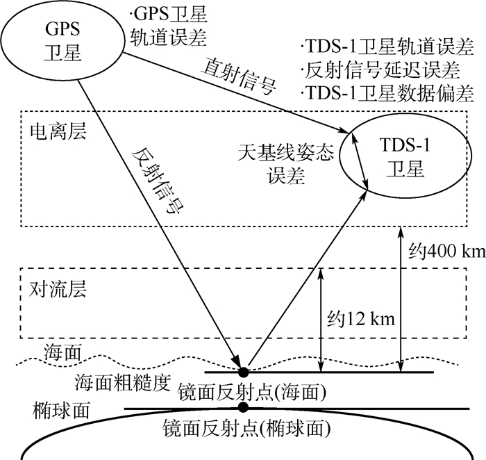
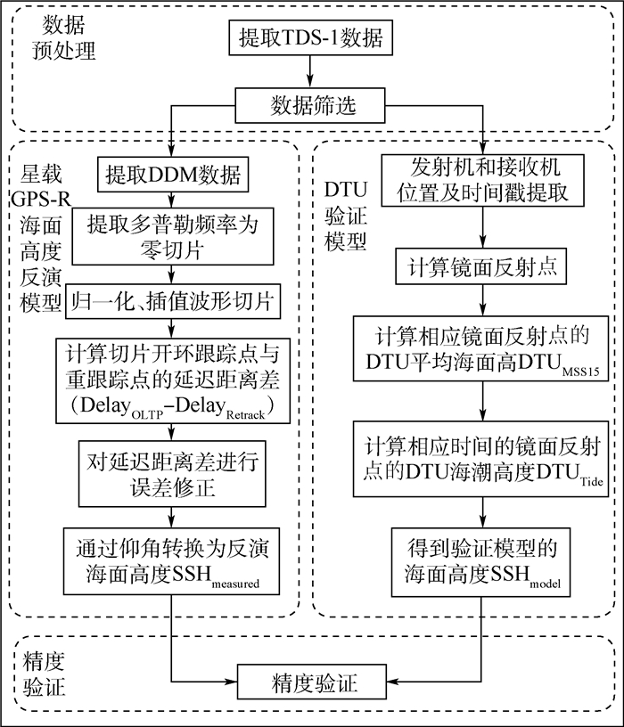
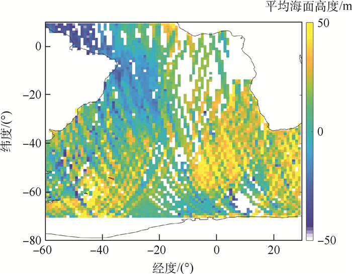
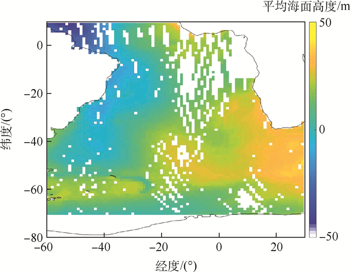
The problems of using GPS-Reflectometry (GPS-R) measured data to establish satellite-borne sea surface height inversion model are studied and its validity is verified. The data of TechDemoSat-1 (TDS-1) and the retrieval technique of Delay-Doppler Map (DDM) were used to analyze the errors in the retrieval of satellite-borne GPS-R sea surface height, and the error models were established. The satellite-borne GPS-R sea surface height inversion model was optimized. Meanwhile, the DTU15 global mean sea surface and sea tide model was adopted to verify the inversion accuracy. The results show that the Mean Absolute Deviation (MAD) of the global sea surface height inversion results obtained by the optimized inversion model is 6.05 meters, and the accuracy is improved by about 29%, effectively improving the accuracy of SST inversion. The research results have certain significance for promoting the application of spaceborne GNSS-Reflectometry (GNSS-R) in sea surface height inversion.

| [1] |
孙剑. GNSS-R海洋反射接收机的控制设计及实现[D]. 北京: 中国科学院空间科学与应用研究中心, 2010: 2-5.
SUN J. Design and realization of control system for the GNSS-R receiver[D]. Beijing: Center for Space Science and Applied Research, Chinese Academy of Sciences, 2010: 2-5(in Chinese).
|
| [2] |
MARTIN-NEIRA M. A pasive reflectometry and interfeometry system (PARIS) application to ocean altimetry[J]. ESA Journal, 1993, 17(4): 331-355.
|
| [3] |
PARK H, VALENCIA E, CAMPS A, et al. Delay tracking in spaceborne GNSS-R ocean altimetry[J]. IEEE Geoscience and Remote Sensing Letters, 2013, 10(1): 57-61. doi: 10.1109/LGRS.2012.2192255
|
| [4] |
张云, 谢向芳, 孟婉婷, 等. 基于北斗GEO卫星反射信号的渤海海冰检测[J]. 北京航空航天大学学报, 2018, 44(2): 257-263. doi: 10.13700/j.bh.1001-5965.2017.0149
ZHANG Y, XIE X F, MENG W T, et al. Bohai coastal sea ice detection using BeiDou GEO satellite reflected signals[J]. Journal of Beijing University of Aeronautics and Astronautics, 2018, 44(2): 257-263(in Chinese). doi: 10.13700/j.bh.1001-5965.2017.0149
|
| [5] |
ZHANG Y, TIAN L M, MENG W T, et al. Feasibility of code-level altimetry using coastal BeiDou reflection (BeiDou-R) setups[J]. IEEE Journal of Selected Topics in Applied Earth Observations and Remote Sensing, 2015, 8(8): 4130-4140. doi: 10.1109/JSTARS.2015.2446684
|
| [6] |
ZHANG Y, LI B B, TIAN L M, et al. Phase altimetry using reflected signals from BeiDou GEO satellites[J]. IEEE Geoscience and Remote Sensing Letters, 2016, 13(10): 1-5. doi: 10.1109/LGRS.2016.2596724
|
| [7] |
刘风玲, 张云, 孟婉婷, 等. UK-DMC卫星接收机GNSS反射信号的应用分析[J]. 遥感信息, 2015, 30(1): 90-95. https://www.cnki.com.cn/Article/CJFDTOTAL-YGXX201501015.htm
LIU F L, ZHANG Y, MENG W T, et al. Application analysis of airborne GNSS reflected data from UK-DMC satellite receiver[J]. Remote Sensing Information, 2015, 30(1): 90-95(in Chinese). https://www.cnki.com.cn/Article/CJFDTOTAL-YGXX201501015.htm
|
| [8] |
CLARIZIA M P, RUF C, CIPOLLINI P, et al. First spaceborne observation of sea surface height using GPS-reflectometry[J]. Geophysical Research Letters, 2016, 43(2): 767-774. doi: 10.1002/2015GL066624
|
| [9] |
MASHBURN J, AXELRAD P, LOWE S T, et al. Global ocean altimetry with GNSS reflections from TechDemoSat-1[J]. IEEE Transactions on Geoscience and Remote Sensing, 2018, 56(7): 4088-4097. doi: 10.1109/TGRS.2018.2823316
|
| [10] |
LI W Q, CARDELLACH E, FABRA F, et al. Assessment of spaceborne GNSS-R ocean altimetry performance using CYGNSS mission raw data[J]. IEEE Transactions on Geoscience and Remote Sensing, 2020, 58(1): 238-250. doi: 10.1109/TGRS.2019.2936108
|
| [11] |
XU L W, WAN W, CHEN X W, et al. Spaceborne GNSS-R observation of global lake level: First results from the TechDemoSat-1 mission[J]. Remote Sensing, 2019, 11(12): 1438. doi: 10.3390/rs11121438
|
| [12] |
张云, 张杨阳, 孟婉婷, 等. 机载GNSS反射信号海面测高模型的研究[J]. 海洋学报, 2020, 42(3): 149-156. https://www.cnki.com.cn/Article/CJFDTOTAL-SEAC202003014.htm
ZHANG Y, ZHANG Y Y, MENG W T, et al. Research on sea surface altimetry model of airborne GNSS reflected signal[J]. Acta Oceanologica Sinica, 2020, 42(3): 149-156(in Chinese). https://www.cnki.com.cn/Article/CJFDTOTAL-SEAC202003014.htm
|
| [13] |
JALES P. MERRByS product manual-GNSS reflectometry on TDS-1 with the SGRReSI V4[EB/OL]. (2018-01-02)[2020-07-01]. http://merrbys.co.uk/resources/documentation.
|
| [14] |
GARRISON J L, KATZBERG S J. The application of reflected GPS signals to ocean remote sensing[J]. Remote Sensing of Environment, 2000, 73(2): 175-187. doi: 10.1016/S0034-4257(00)00092-4
|
| [15] |
BILITZA D. The international reference ionosphere-status 2013[J]. Advances in Space Research, 2015, 55(8): 1914-1927. doi: 10.1016/j.asr.2014.07.032
|
| [16] |
NIELL A E. Global mapping functions for the atmosphere delay at radio wavelengths[J]. Journal of Geophysical Research Solid Earth, 1996, 101(B2): 3227-3246. doi: 10.1029/95JB03048
|
| [17] |
DOW J M, NEILAN R E, RIZOS C. The international GNSS service in a changing landscape of global navigation satellite systems[J]. Journal of Geodesy, 2009, 83(3-4): 191-198. doi: 10.1007/s00190-008-0300-3
|
| [18] |
HU C J, BENSON C R, RIZOS C, et al. Impact of receiver dynamics on space-based GNSS-R altimetry[J]. IEEE Journal of Selected Topics in Applied Earth Observations and Remote Sensing, 2019, 12(6): 1974-1980. doi: 10.1109/JSTARS.2019.2910544
|
| [19] |
ANDERSEN O B. The DTU10 gravity field and mean sea surface[C]//Second International Symposium of the Gravity Field of the Earth (IGFS2), 2010.
|
| [20] |
MASHBURN J, AXELRAD P, LOWE S T, et al. An assessment of the precision and accuracy of altimetry retrievals for a Monterey Bay GNSS-R experiment[J]. IEEE Journal of Selected Topics in Applied Earth Observations and Remote Sensing, 2016, 9(10): 4660-4668. doi: 10.1109/JSTARS.2016.2537698
|

Figures(10) / Tables(3)
Copyright © Journal of Beijing University of Aeronautics and Astronautics
Address: Editorial Department of Journal of Beijing University of Aeronautics and Astronautics, 37 Xueyuan Road, Haidian District, Beijing Post Code: 100191 Email: jbuaa@buaa.edu.cn
Supported by:
Beijing Renhe Information Technology Co., Ltd.


 DownLoad: