| Citation: | ZHU Yongwen, PU Fan. Principle and application of airspace spatial grid identification[J]. Journal of Beijing University of Aeronautics and Astronautics, 2021, 47(12): 2462-2474. doi: 10.13700/j.bh.1001-5965.2020.0487(in Chinese)

|
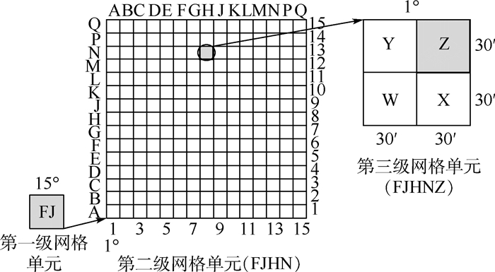
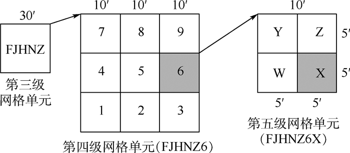
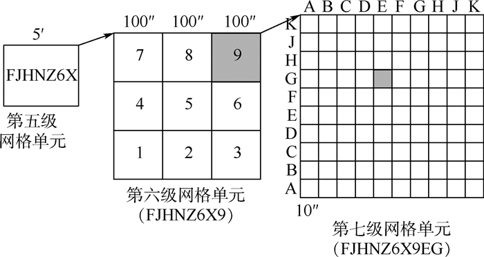
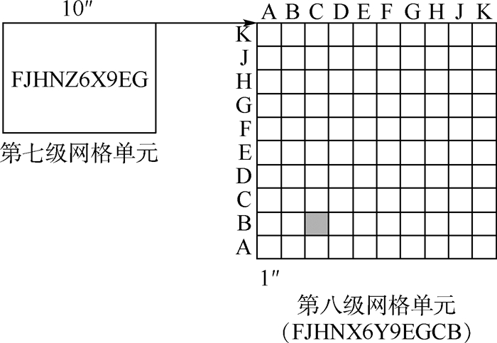
At present, in the related researches of airspace spatial finite element, the construction of a grid identification system for airspace space is an important foundation for applying information technology to airspace management and promoting airspace digitization. Based on the US military's global regional reference system and general geographic location reference system, this paper proposes a reference system that has the ability to identify both plane and three-dimensional spatial positions. By establishing a recursive system in the space below a specific height above the earth's surface, the airspace space is divides into several spatial grids. Grid at different scales is not only a geographic spatial position reference system, but also a basic airspace body that composes the airspace, which means to realize spatial position reference and spatial position calibration. The mixed expression of airspace provides an underlying model for the development of digital airspace management.
| [1] |
高波, 祁志民. 数字化作战对炮兵装备的影响[J]. 火力与指挥控制, 2005, 30(7): 46-49. doi: 10.3969/j.issn.1002-0640.2005.07.013
GAO B, QI Z M. The impact of digital warfare on artillery equipment[J]. Firepower and Command Control, 2005, 30(7): 46-49(in Chinese). doi: 10.3969/j.issn.1002-0640.2005.07.013
|
| [2] |
张卫民, 马红卫, 梁建奇, 等. 坐标系选取对炮兵作战的影响分析[J]. 兵工学报, 2014, 35(10): 1716-1720. doi: 10.3969/j.issn.1000-1093.2014.10.028
ZHANG W M, MA H W, LIANG J Q, et al. Analysis of the influence of coordinate system selection on artillery operations[J]. Acta Armamentarii, 2014, 35(10): 1716-1720(in Chinese). doi: 10.3969/j.issn.1000-1093.2014.10.028
|
| [3] |
赵琳, 程建华, 赵玉新. 船舶导航定位系统[M]. 哈尔滨: 哈尔滨工程大学出版社, 2011.
ZHAO L, CHENG J H, ZHAO Y X. Ship navigation and positioning system[M]. Harbin: Harbin Engineering University Press, 2011(in Chinese).
|
| [4] |
贾银山, 贾传荧, 魏海平, 等. 基于GPS和电子海图的船舶导航系统设计与实现[J]. 计算机工程, 2003, 29(1): 194-195. doi: 10.3969/j.issn.1000-3428.2003.01.076
JIA Y S, JIA C Y, WEI H P, et al. Design and implementation of ship navigation system based on GPS and electronic chart[J]. Computer Engineering, 2003, 29(1): 194-195(in Chinese). doi: 10.3969/j.issn.1000-3428.2003.01.076
|
| [5] |
刘俊义, 任建芳. 地理信息系统中空间参考系统综述[J]. 通信与计算技术, 2006(4): 23-29.
LIU J Y, REN J F. Overview of spatial reference system in geographic information system[J]. Communication and Computing Technology, 2006(4): 23-29(in Chinese).
|
| [6] |
盛英帅, 胡清雄, 高辉, 等. 地球空间参考网格系统建设初探[J]. 北京大学学报(自然科学版), 2016, 52(6): 1041-1049.
SHENG Y S, HU Q X, GAO H, et al. A preliminary study on the construction of geospatial reference grid system[J]. Journal of Peking University(Natural Science Edition), 2016, 52(6): 1041-1049(in Chinese).
|
| [7] |
程承旗, 付晨. 地球空间参考网格及应用前景[J]. 地理信息世界, 2014(3): 1-8. doi: 10.3969/j.issn.1672-1586.2014.03.001
CHENG C Q, FU C. Geospatial reference grid and its application prospects[J]. Geographic Information World, 2014(3): 1-8(in Chinese). doi: 10.3969/j.issn.1672-1586.2014.03.001
|
| [8] |
胡丹露. 地理信息网格及其军事应用[J]. 测绘科学, 2005, 30(1): 15-17. doi: 10.3771/j.issn.1009-2307.2005.01.005
HU D L. Geographic information grid and its military application[J]. Science of Surveying and Mapping, 2005, 30(1): 15-17(in Chinese). doi: 10.3771/j.issn.1009-2307.2005.01.005
|
| [9] |
仲廷虎, 曹雪峰. 军事网格带来作战指挥的新发展[J]. 国防科技, 2007(4): 64-65. doi: 10.3969/j.issn.1671-4547.2007.04.016
ZHONG T H, CAO X F. Military grid brings new development in combat command[J]. National Defense Science and Technology, 2007(4): 64-65(in Chinese). doi: 10.3969/j.issn.1671-4547.2007.04.016
|
| [10] |
吕晓华, 万刚, 宗传孟. 美国军事网格参考系统及其启示[J]. 测绘科学与工程, 2008, 28(4): 69-73.
LÜ X H, WAN G, ZONG C M. The U.S. military grid reference system and its enlightenment[J]. Science and Engineering of Surveying and Mapping, 2008, 28(4): 69-73(in Chinese).
|
| [11] |
叶昆平. 基于基准站网的区域参考框架维持及精度分析[J]. 测绘与空间地理信息, 2019, 42(8): 148-150. doi: 10.3969/j.issn.1672-5867.2019.08.043
YE K P. Regional reference frame maintenance and accuracy analysis based on fiducial station network[J]. Surveying and Spatial Geographic Information, 2019, 42(8): 148-150(in Chinese). doi: 10.3969/j.issn.1672-5867.2019.08.043
|
| [12] |
张西光, 吕志平. 论地球参考框架的维持[J]. 测绘通报, 2009(5): 1-4.
ZHANG X G, LÜ Z P. On the maintenance of the earth reference frame[J]. Bulletin of Surveying and Mapping, 2009(5): 1-4(in Chinese).
|
| [13] |
关丽, 吕雪锋. 多级地理空间网格框架及其关键技术初探[J]. 地理与地理信息科学, 2011, 27(3): 1-6.
GUAN L, LÜ X F. A preliminary study on the multi-level geospatial grid framework and its key technologies[J]. Geography and Geo-Information Science, 2011, 27(3): 1-6(in Chinese).
|
| [14] |
BEN J, TONG X, JI S. Global grid systems for geospatial information: Status and thinking[C]//Proceedings of SPIE, 2007: 6754.
|
| [15] |
CHEN A J, DI L P, WEI Y X. Use of grid computing for modeling virtual geospatial products[J]. International Journal of Geographical Information Science, 2009, 23(5): 581-604. doi: 10.1080/13658810902733666
|
| [16] |
ZHANG T, TSOU M H, QIAO Q, et al. Building an intelligent geospatial cyberinfrastructure: An analytical problem solving approach[C]//Geoinformatics 2006: Geospatial Information Science, 2006: 64200A.
|
| [17] |
FANG Y, HUANG Z, CHEN B, et al. Architecture and key technologies of grid geographic information system[J]. Science China-Technological Sciences, 2008, 51(1): 102-113. doi: 10.1007/s11431-008-5011-8
|
| [18] |
林珲, 黄凤茹, 鲁学军, 等. 虚拟地理环境认知与表达研究初步[J]. 遥感学报, 2010, 14(4): 822-838.
LIN H, HUANG F R, LU X J, et al. Preliminary research on the cognition and expression of virtual geographic environment[J]. Journal of Remote Sensing, 2010, 14(4): 822-838(in Chinese).
|
| [19] |
龚建华, 周洁萍, 张利辉. 虚拟地理环境研究进展与理论框架[J]. 地球科学进展, 2010, 25(9): 915-926.
GONG J H, ZHOU J P, ZHANG L H. Research progress and theoretical framework of virtual geographical environment[J]. Advances in Earth Science, 2010, 25(9): 915-926(in Chinese).
|
| [20] |
李德仁, 龚健雅, 邵振峰. 从数字地球到智慧地球[J]. 武汉大学学报(信息科学版), 2010, 35(2): 127-132.
LI D R, GONG J Y, SHAO Z F. From digital earth to smart earth[J]. Journal of Wuhan University(Information Science Edition), 2010, 35(2): 127-132(in Chinese).
|
| [21] |
翟卫欣, 段杰雄, 童晓冲, 等. 基于空间网格的多尺度人文地理特征分析[J]. 测绘学报, 2016, 45(z1): 85-89.
ZHAI W X, DUAN J X, TONG X C, et al. Multi-scale analysis of human geographic features based on spatial grid[J]. Journal of Surveying and Mapping, 2016, 45(z1): 85-89(in Chinese).
|
| [22] |
彭明军. 利用层次空间推理进行城市空间信息多级网格划分[J]. 武汉大学学报(信息科学版), 2010, 35(9): 1112-1115.
PENG M J. Using hierarchical spatial reasoning for multi-level grid division of urban spatial information[J]. Journal of Wuhan University(Information Science Edition), 2010, 35(9): 1112-1115(in Chinese).
|
| [23] |
李德仁, 肖志峰, 朱欣焰, 等. 空间信息多级网格的划分方法及编码研究[J]. 测绘学报, 2006, 35(1): 52-56. doi: 10.3321/j.issn:1001-1595.2006.01.011
LI D R, XIAO Z F, ZHU X Y, et al. Research on the division method and coding of spatial information multi-level grid[J]. Journal of Surveying and Mapping, 2006, 35(1): 52-56(in Chinese). doi: 10.3321/j.issn:1001-1595.2006.01.011
|
| [24] |
韩海东, 程承旗, 王燕, 等. 基于全球剖分网格的多源数据快速汇集方法研究[J]. 地理信息世界, 2014(6): 6-11. doi: 10.3969/j.issn.1672-1586.2014.06.002
HAN H D, CHENG C Q, WANG Y, et al. Research on the rapid collection method of multi-source data based on global subdivision grid[J]. Geographic Information World, 2014(6): 6-11(in Chinese). doi: 10.3969/j.issn.1672-1586.2014.06.002
|
| [25] |
SAHR K, WHITE D, KIMERLING A J. Discrete global grid system[J]. Cartography and Geographic Information Science, 2003, 30(2): 121-134. doi: 10.1559/152304003100011090
|
| [26] |
TONG X, BEN J, WANG Y, et al. Efficient encoding and spatial operation scheme for aperture 4 hexagonal discrete global grid system[J]. International Journal of Geographical Information Science, 2013, 27(5-6): 898-921.
|
| [27] |
贲进, 童晓冲, 张衡, 等. 基于六边形网格的球面Voronoi图生成算法[J]. 测绘科学技术学报, 2006, 23(5): 328-330. doi: 10.3969/j.issn.1673-6338.2006.05.005
BEN J, TONG X C, ZHANG H, et al. Spherical Voronoi diagram generation algorithm based on hexagonal grid[J]. Journal of Surveying and Mapping Science and Technology, 2006, 23(5): 328-330(in Chinese). doi: 10.3969/j.issn.1673-6338.2006.05.005
|
| [28] |
贲进. 地球空间信息离散网格数据模型的理论与算法研究[D]. 郑州: 解放军信息工程大学, 2005.
BEN J. Research on theories and algorithms of discrete grid data model for geospatial information[D]. Zhengzhou: PLA Information Engineering University, 2005(in Chinese).
|
| [29] |
KIM I H, TSOU M H. Enabling digital earth simulation models using cloud computing or grid computing-Two approaches supporting high-performance GIS simulation frameworks[J]. International Journal of Digital Earth, 2013, 6(4): 383-403. doi: 10.1080/17538947.2013.783125
|
| [30] |
YANG C, GOODCHILD M, HUANG Q, et al. Spatial cloud computing: How can the geospatial sciences use and help shape cloud computing[J]. International Journal of Digital Earth, 2011, 4(4): 305-329. doi: 10.1080/17538947.2011.587547
|
| [31] |
文秘, 方强, 黄兴龙, 等. 基于RGRS的空域划设问题研究[J]. 兵器装备工程学报, 2020, 41(3): 194-199. doi: 10.11809/bqzbgcxb2020.03.039
WEN M, FANG Q, HUANG X L, et al. Spatial allocation of global grid reference system based on radian system[J]. Journal of Ordnance Equipment Engineering, 2020, 41(3): 194-199(in Chinese). doi: 10.11809/bqzbgcxb2020.03.039
|
| [32] |
MIAO S, CHENG C, ZHAI W, et al. A low-altitude flight conflict detection algorithm based on a multilevel grid spatiotemporal index[J]. International Journal of Geo-Information, 2019, 8(6): 289. doi: 10.3390/ijgi8060289
|
| [33] |
ACEVEDO J J, CASTANO A R, ANDRADE-PINEDA J L. A 4D grid based approach for efficient conflict detection in large-scale multi-UAV scenarios[C]//The 2019 International Workshop on Research, Education and Development on Unmanned Aerial Systems. Piscataway: IEEE Press, 2019: 18-23.
|
| [34] |
HAN Y X, HUANG X Q, TANG X M. Development of a new tool for constrained conflict resolution[J]. Journal of Airspace Engineering, 2019, 233(5): 1683-1694.
|
| 1. | 谢华,尹嘉男,朱永文,陈志杰. 数字低空空域栅格化的表征度量与最优标定. 数据采集与处理. 2024(01): 31-43 .  | |
| 2. | 窦雪倩,王文兵,刘美琪. 面向电磁态势的空间网格处理方法研究. 舰船电子对抗. 2024(05): 70-74 . | |
| 3. | 陈志杰,朱永文,刘杨. 基于数字化空域系统的城市无人机管理对策研究. 中国民航大学学报. 2023(03): 8-12+64 . | |
| 4. | 谢华,苏方正,尹嘉男,韩斯特,张新珏. 复杂低空无人机飞行冲突网络建模与精细管理. 航空学报. 2023(18): 221-241 . | |
| 5. | 张翊知,周镕彬,王宏飞,李梁,石永康. 陆航直升机空域协调方法研究. 指挥控制与仿真. 2021(06): 100-105 . |


Figures(14) / Tables(10)
Copyright © Journal of Beijing University of Aeronautics and Astronautics
Address: Editorial Department of Journal of Beijing University of Aeronautics and Astronautics, 37 Xueyuan Road, Haidian District, Beijing Post Code: 100191 Email: jbuaa@buaa.edu.cn
Supported by:
Beijing Renhe Information Technology Co., Ltd.

Guo Xiaowei, Ma Dengwu, Deng Liet al. Optimal allocation of air ammunition support crew based on PERT networks[J]. Journal of Beijing University of Aeronautics and Astronautics, 2014, 40(1): 69-74. (in Chinese)


 DownLoad: