| Citation: | WU S Y,YANG D K,WANG F,et al. GNSS-R BSAR range-Doppler imaging algorithm based on synchronization of direct and echo signal[J]. Journal of Beijing University of Aeronautics and Astronautics,2023,49(3):588-596 (in Chinese) doi: 10.13700/j.bh.1001-5965.2021.0310

|
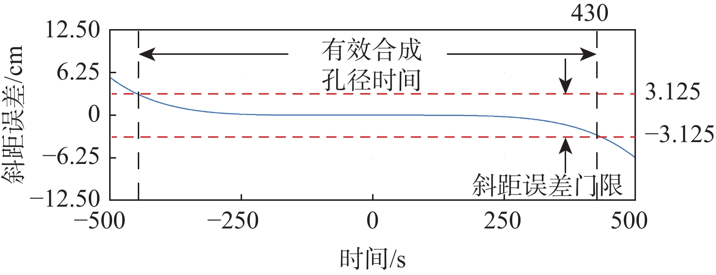
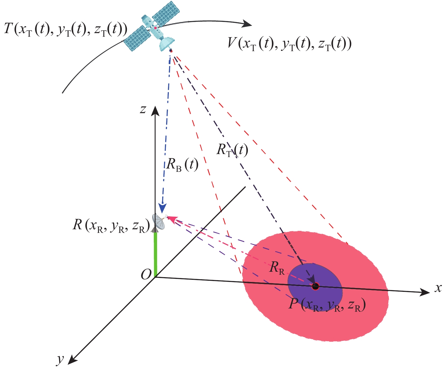
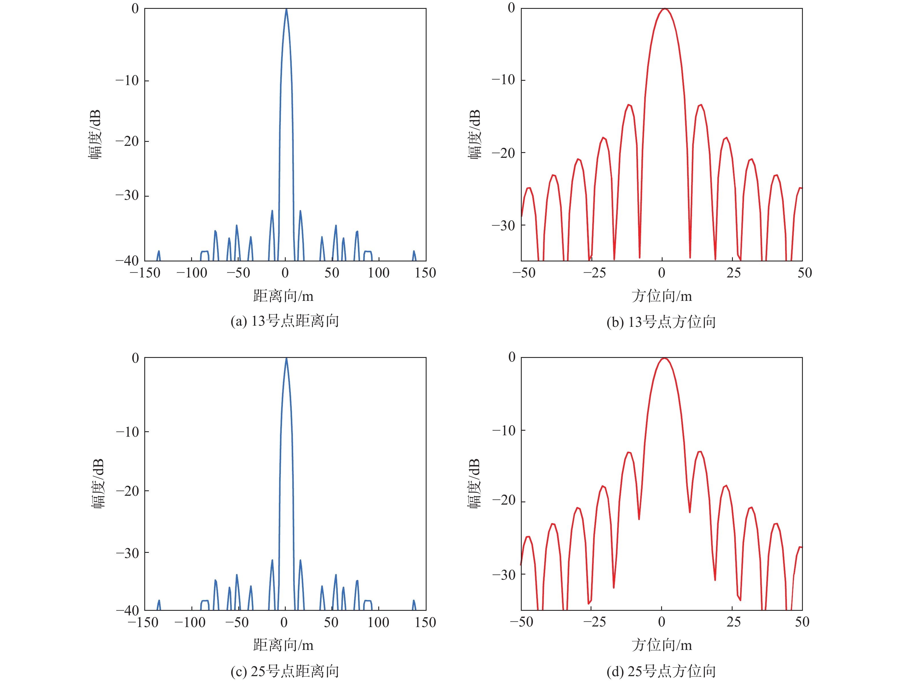
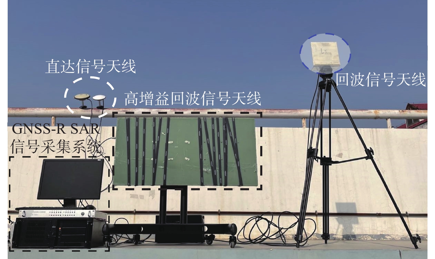
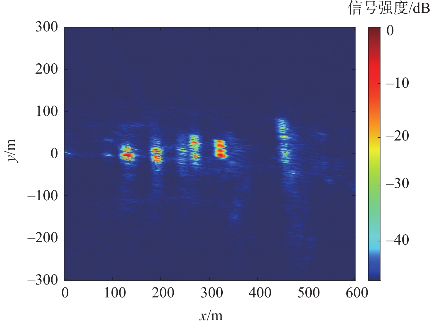
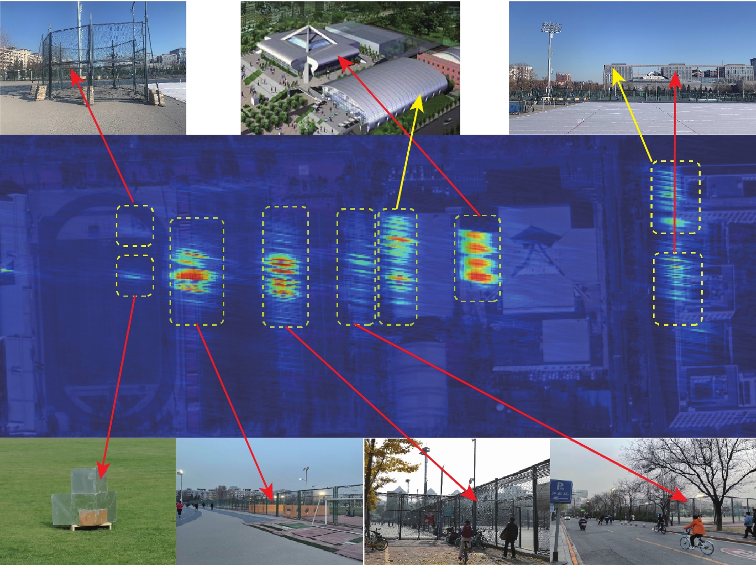
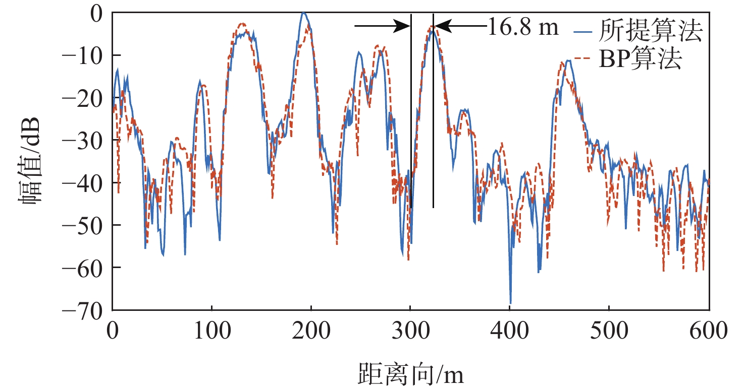
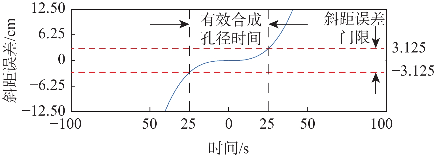
Aiming at the problems that the current global navigation satellite system-reflectometry bistatic synthetic aperture radar (GNSS-R BSAR) has a large squint in the fixed mode of one station, the slant range history is complicated, and the echo signal's azimuth is changed, the echo signal is difficult to process, an improved Range Doppler imaging algorithm is proposed. The method uses GNSS signal as the radiation source, and introduces a high-order squint range model based on the long GNSS-R BSAR synthetic aperture time in the one-stop fixed mode to obtain an accurate description of the relative time variation of the squint range between the navigation satellite and the target. Based on this model, firstly, the range migration is corrected by the time-domain cancellation of the direct signal and the echo signal to realize the accurate correction of the target range migration in the whole scene; By azimuth-block hybrid correlation processing, the azimuth shifting nature of the echo signal is overcome, and efficient and accurate imaging of the whole scene is realized. The imaging efficiency of the proposed algorithm is better than that of the traditional BP algorithm, the imaging accuracy is comparable to that of the back projection (BP) algorithm, and the focusing effect can be improved by adjusting the width of the orientation bins as needed. Finally, to validate the proposed algorithm, we conducted simulations and experiments with GPS-L5 signals , the simulation and experimental results verified the feasibility and efficiency of the proposed algorithm.

| [1] |
ANTONIOU M, CHERNIAKOV M. GNSS-based bistatic SAR: A signal processing view[J]. EURASIP Journal on Advances in Signal Processing, 2013(1): 1-16.
|
| [2] |
ANTONIOU M, STOVE A, SAYIN A, et al. Passive SAR satellite constellation for near-persistent earth observation: Prospects and issues[J]. IEEE Aerospace and Electronic Systems Magazine, 2018, 33: 4-15. doi: 10.1109/MAES.2018.8650001
|
| [3] |
WANG F, YANG D, YANG L. Feasibility of wind direction observation using low-altitude global navigation satellite system-reflectometry[J]. IEEE Journal of Selected Topics in Applied Earth Observations and Remote Sensing, 2018, 11(12): 5063-5075. doi: 10.1109/JSTARS.2018.2877388
|
| [4] |
MARTIN-NEIRA M. A passive reflectometry and interferometry system (PARIS): Application to ocean altimetry[J]. ESA Journal, 1993, 17: 331-355.
|
| [5] |
RODRIGUEZ-ALVAREZ N, BOSCH-LLUIS X, CAMPS A, et al. Soil moisture retrieval ssing GNSS-R techniques: Experimental results over a bare soil field[J]. IEEE Transactions on Geoscience and Remote Sensing, 2009, 47(11): 3616-3624. doi: 10.1109/TGRS.2009.2030672
|
| [6] |
洪学宝, 张波, 阮宏梁, 等. 基于相关功率修正的地基GNSS-R土壤湿度反演[J]. 北京航空航天大学学报, 2021, 47(8): 1558-1564. doi: 10.13700/j.bh.1001-5965.2020.0154
HONG X B, ZHANG B, RUAN H L, et al. Ground-based GNSS-R soil moisture retrieval based on correlation power correction[J]. Journal of Beijing University of Aeronautics and Astronautics, 2021, 47(8): 1558-1564(in Chinese). doi: 10.13700/j.bh.1001-5965.2020.0154
|
| [7] |
ZHOU X, WANG P, CHEN J, et al. A modified radon fourier transform for GNSS-based bistatic radar target detection[J]. IEEE Geoscience and Remote Sensing Letters, 2020(99): 1-5.
|
| [8] |
GAO C, YANG D, HONG X, et al. Experimental results about traffic flow detection by using GPS reflected signals[J]. IEEE Journal of Selected Topics in Applied Earth Observations and Remote Sensing, 2018, 11(12): 5076-5087. doi: 10.1109/JSTARS.2018.2882232
|
| [9] |
LIU F, FAN X, ZHANG T, et al. GNSS-Based SAR interferometry for 3-D deformation retrieval: Algorithms and feasibility study[J]. IEEE Transactions on Geoscience and Remote Sensing, 2018, 56(10): 5736-5748.
|
| [10] |
LIU F, ANTONIOU M, ZENG Z, et al. Coherent change detection using passive GNSS-Based BSAR: Experimental proof of concept[J]. IEEE Transactions on Geoscience and Remote Sensing, 2013, 51(8): 4544-4555.
|
| [11] |
仇晓兰, 丁赤飚, 胡东辉. 双站SAR成像处理技术[M]. 北京: 科学技术出版社, 2010: 147-148.
QIU X L, DING C B, HU D H. Double-station SAR imaging processing technology[M]. Beijing: Science and Technology Press, 2010: 147-148 (in chinese ) .
|
| [12] |
SHAO Y F, WANG R, DENG Y K, et al. Fast backprojection algorithm for bistatic SAR imaging[J]. IEEE Transations on Geoscience and Remote Sensing, 2013, 10(5): 1080-1084. doi: 10.1109/LGRS.2012.2230243
|
| [13] |
ANTONIOU M, SAINI R, CHERNIAKOV M. Results of a space-surface bistatic SAR image formation algorithm[J]. IEEE Transactions on Geoscience and Remote Sensing, 2007, 45(11): 3359-3371. doi: 10.1109/TGRS.2007.902124
|
| [14] |
ZENG T, WANG R, LI F, et al. A modified nonlinear chirp scaling algorithm for spaceborne/stationary bistatic SAR based on series reversion[J]. IEEE Transactions on Geoscience and Remote Sensing, 2013, 51(5): 3108-3118. doi: 10.1109/TGRS.2012.2219057
|
| [15] |
ZHOU X K, CHEN J, WANG P B, et al. An efficient imaging algorithm for GNSS-R bi-static SAR[J]. Remote Sensing, 2019, 11(24): 2945. doi: 10.3390/rs11242945
|
| [16] |
WANG P, LIU W, CHEN J, et al. A high-order imaging algorithm for high-resolution spaceborne SAR based on a modified equivalent squint range model[J]. IEEE Transactions on Geoscience and Remote Sensing, 2015, 53(3): 1225-1235. doi: 10.1109/TGRS.2014.2336241
|
| [17] |
黄岩, 李春升, 陈杰, 等. 高分辨星载SAR改进ChirpScaling成像算法[J]. 电子学报, 2000, 28(3): 35-38. doi: 10.3321/j.issn:0372-2112.2000.03.010
HUANG Y, LI C S, CHEN J, et al. Improved ChirpScaling imaging algorithm for high resolution spaceborne SAR[J]. Acta Electronics, 2000, 28(3): 35-38(in Chinese). doi: 10.3321/j.issn:0372-2112.2000.03.010
|
| [18] |
ZENG H C, WANG P B, CHEN J, et al. A novel general imaging formation algorithm for GNSS-based bistatic SAR[J]. Sensors, 2016, 16(3): s16030294.
|
Figures(15) / Tables(7)
Copyright © Journal of Beijing University of Aeronautics and Astronautics
Address: Editorial Department of Journal of Beijing University of Aeronautics and Astronautics, 37 Xueyuan Road, Haidian District, Beijing Post Code: 100191 Email: jbuaa@buaa.edu.cn
Supported by:
Beijing Renhe Information Technology Co., Ltd.


 DownLoad: