| Citation: | ZHOU X,ZHENG N S,DING R,et al. An improved inversion method of forest biomass based on satellite GNSS-R[J]. Journal of Beijing University of Aeronautics and Astronautics,2024,50(8):2619-2626 (in Chinese) doi: 10.13700/j.bh.1001-5965.2022.0654

|
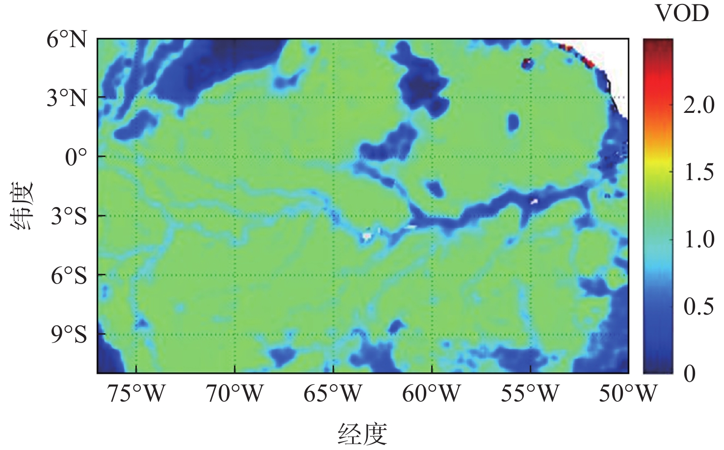
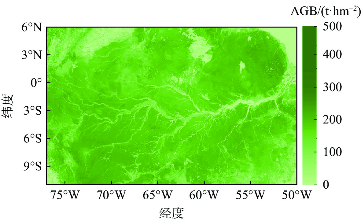
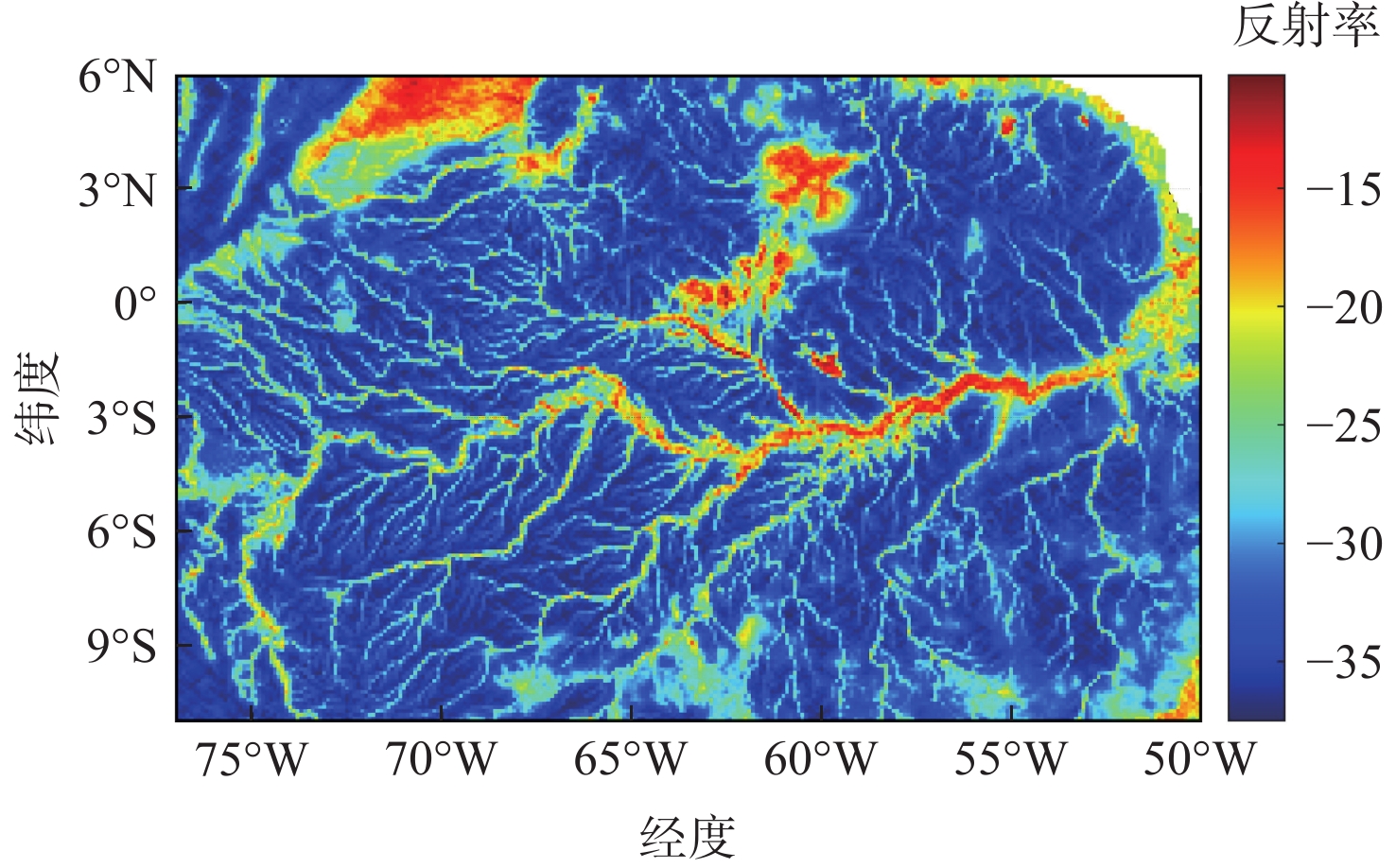
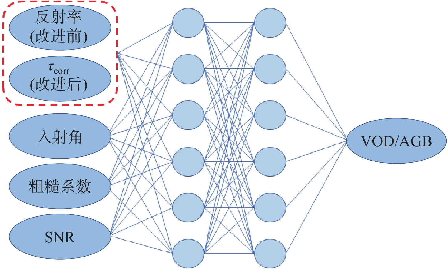
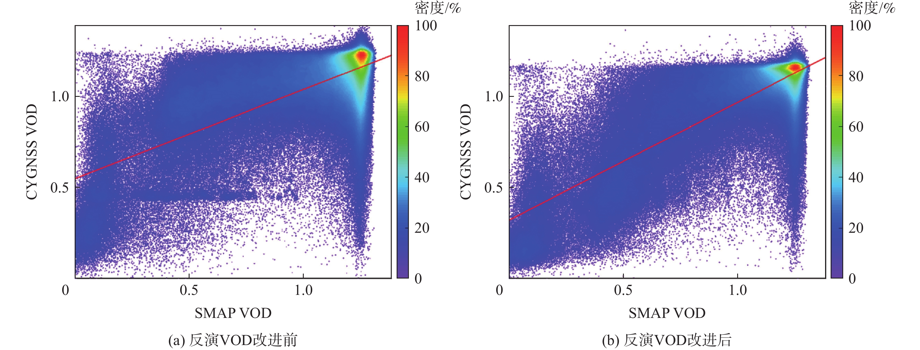
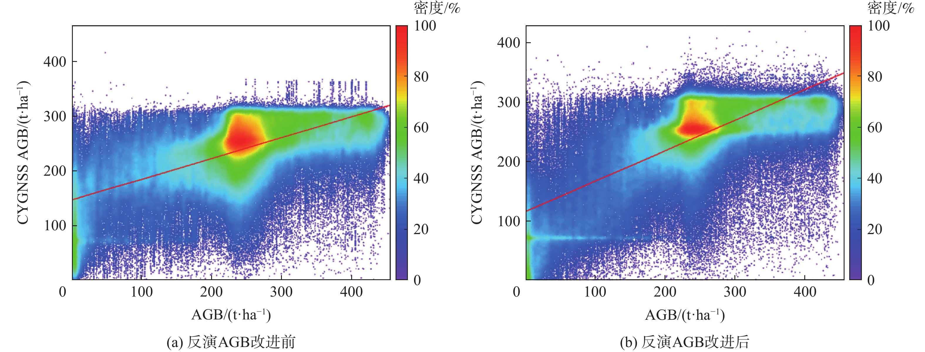
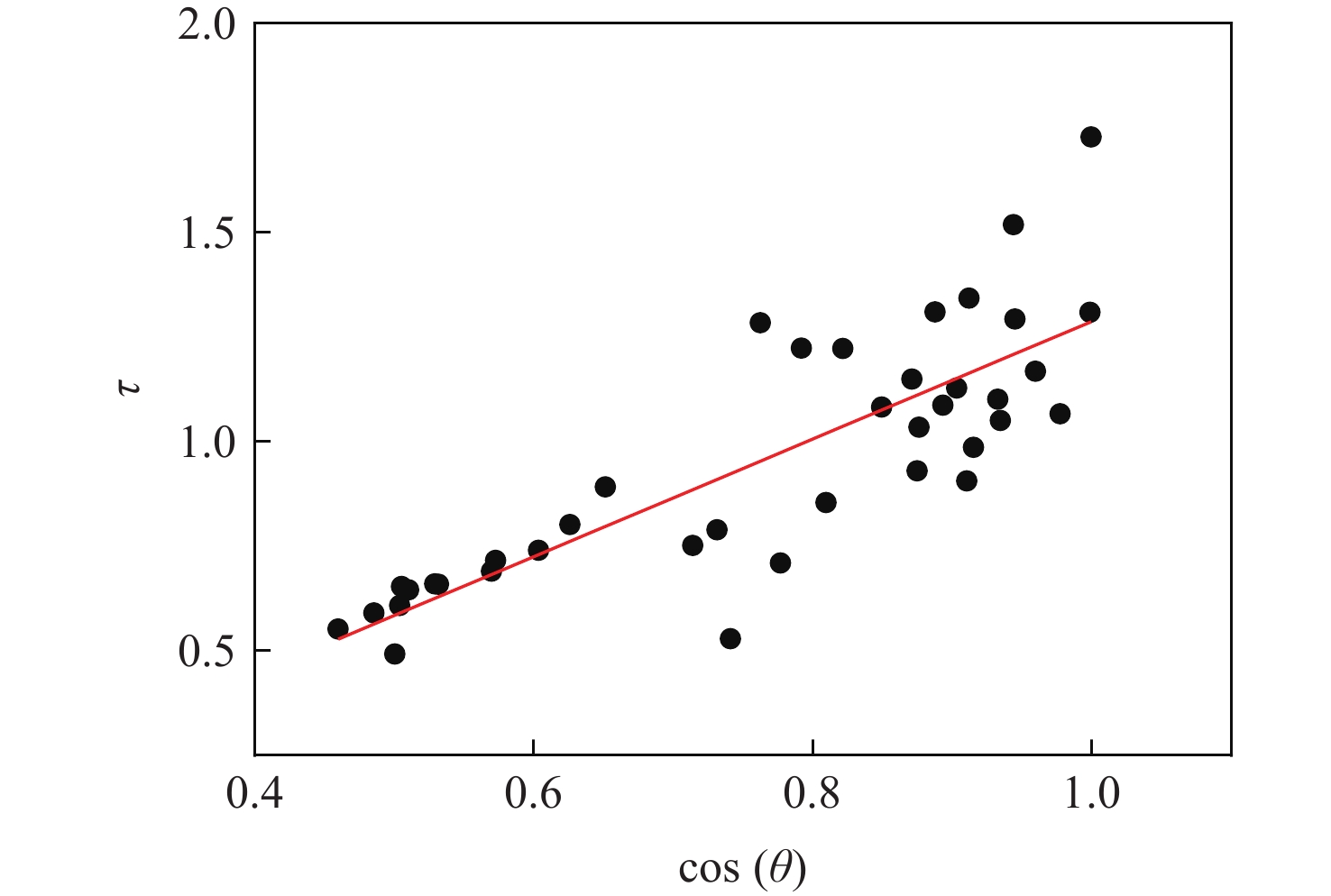
Based on the Tau-Omega model, a spaceborne global navigation satellite system relectometry (GNSS-R) forest aboveground biomass inversion method considering the correction of ground soil moisture is proposed. The cyclone global navigation satellite system (CYGNSS) reflectance was corrected using the Tau-Omega model to increase the modeling parameters' accuracy, and SMAP satellite soil moisture was chosen as supplementary data. The biomass reference data utilized was the vegetation optical depth (VOD) supplied by SMAP satellite and the above-ground biomass (AGB) maps. The correlation changes between the observed values and the reference data prior to and following improvement were compared. The results show that the correlation coefficient increases significantly after the correction. The correlation coefficient between the parameters after improvement with VOD is increased from 0.54 to 0.67 compared to the reflectivity with VOD, and the correlation coefficient with AGB is increased from 0.46 to 0.56. Then, the GNSS-R VOD and AGB inversion models were established based on the corrected parameters and reflectivity through the artificial neural network, respectively. The results show that the improved method can effectively improve the inversion accuracy of VOD and AGB, and the improvement effect is better in areas with low biomass levels. For VOD inversion, after improvement, the correlation coefficient increased from 0.70 to 0.83, and the RMES decreased from 0.21 to 0.17; for AGB inversion, after improvement, the correlation coefficient increased from 0.61 to 0.71, and the RMES decreased from 74 t/hm2 to 65 t/hm2.

| [1] |
范文义, 张海玉, 于颖, 等. 三种森林生物量估测模型的比较分析[J]. 植物生态学报, 2011, 35(4): 402-410. doi: 10.3724/SP.J.1258.2011.00402
FAN W Y, ZHANG H Y, YU Y, et al. Comparison of three models of forest biomass estimation[J]. Chinese Journal of Plant Ecology, 2011, 35(4): 402-410(in Chinese). doi: 10.3724/SP.J.1258.2011.00402
|
| [2] |
KELLER M. Revised method for forest canopy height estimation from geoscience laser altimeter system waveforms[J]. Journal of Applied Remote Sensing, 2007, 1(1): 013537. doi: 10.1117/1.2795724
|
| [3] |
CHAVE J, ANDALO C, BROWN S, et al. Tree allometry and improved estimation of carbon stocks and balance in tropical forests[J]. Oecologia, 2005, 145(1): 87-99. doi: 10.1007/s00442-005-0100-x
|
| [4] |
CARRENO-LUENGO H, LUZI G, CROSETTO M. Above-ground biomass retrieval over tropical forests: A novel GNSS-R approach with CyGNSS[J]. Remote Sensing, 2020, 12(9): 1368. doi: 10.3390/rs12091368
|
| [5] |
BAGHDADI N, LE MAIRE G, BAILLY J S, et al. Evaluation of ALOS/PALSAR L-band data for the estimation of eucalyptus plantations aboveground biomass in Brazil[J]. IEEE Journal of Selected Topics in Applied Earth Observations and Remote Sensing, 2015, 8(8): 3802-3811. doi: 10.1109/JSTARS.2014.2353661
|
| [6] |
LE TOAN T, QUEGAN S, DAVIDSON M W J, et al. The BIOMASS mission: Mapping global forest biomass to better understand the terrestrial carbon cycle[J]. Remote Sensing of Environment, 2011, 115(11): 2850-2860. doi: 10.1016/j.rse.2011.03.020
|
| [7] |
GONÇALVES F, TREUHAFT R, LAW B, et al. Estimating aboveground biomass in tropical forests: Field methods and error analysis for the calibration of remote sensing observations[J]. Remote Sensing, 2017, 9(1): 47. doi: 10.3390/rs9010047
|
| [8] |
WU X R, GUO P, SUN Y Q, et al. Recent progress on vegetation remote sensing using spaceborne GNSS-reflectometry[J]. Remote Sensing, 2021, 13(21): 4244. doi: 10.3390/rs13214244
|
| [9] |
ULABY F T. Microwave remote sensing, active and passive[J]. Microwave Remote Sensing Fundamentals and Radiometry, 1981, 1: 191-208.
|
| [10] |
吴学睿, 李颖, 李传龙. 基于Bi-Mimics模型的GNSS-R农作物生物量监测理论研究[J]. 遥感技术与应用, 2012, 27(2): 220-230.
WU X R, LI Y, LI C L. Research on crop biomass monitoring using GNSS-R technique based on Bi-Mimics model[J]. Remote Sensing Technology and Application, 2012, 27(2): 220-230(in Chinese).
|
| [11] |
CHEW C, SHAH R, ZUFFADA C, et al. Demonstrating soil moisture remote sensing with observations from the UK TechDemoSat-1 satellite mission[J]. Geophysical Research Letters, 2016, 43(7): 3317-3324. doi: 10.1002/2016GL068189
|
| [12] |
CAMPS A, PARK H, PABLOS M, et al. Sensitivity of GNSS-R spaceborne observations to soil moisture and vegetation[J]. IEEE Journal of Selected Topics in Applied Earth Observations and Remote Sensing, 2016, 9(10): 4730-4742. doi: 10.1109/JSTARS.2016.2588467
|
| [13] |
CARRENO-LUENGO H, LOWE S T, ZUFFADA C, et al. Spaceborne GNSS-R from the SMAP mission: First assessment of polarimetric scatterometry[C]//Proceedings of the IEEE International Geoscience and Remote Sensing Symposium. Piscataway: IEEE Press, 2017: 4095-4098.
|
| [14] |
WAN W, JI R, LIU B J, et al. A two-step method to calibrate CYGNSS-derived land surface reflectivity for accurate soil moisture estimations[J]. IEEE Geoscience and Remote Sensing Letters, 2020, 19: 2500405.
|
| [15] |
SANTI E, PALOSCIA S, PETTINATO S, et al. Remote sensing of forest biomass using GNSS reflectometry[J]. IEEE Journal of Selected Topics in Applied Earth Observations and Remote Sensing, 2993, 13: 2351-2368.
|
| [16] |
SANTI E, CLARIZIA M P, COMITE D, et al. Detecting fire disturbances in forests by using GNSS reflectometry and machine learning: A case study in Angola[J]. Remote Sensing of Environment, 2022, 270: 112878. doi: 10.1016/j.rse.2021.112878
|
| [17] |
ZHAN Q, VALL-LLOSSERA M, PABLOS M, et al. Improving the rice yield estimation using SMOS and CYGNSS GNSS-R data[C]//Proceedings of the IEEE International Geoscience and Remote Sensing Symposium. Piscataway: IEEE Press, 2020: 5254-5257.
|
| [18] |
KERR Y H, WALDTEUFEL P, RICHAUME P, et al. The SMOS soil moisture retrieval algorithm[J]. IEEE Transactions on Geoscience and Remote Sensing, 2012, 50(5): 1384-1403. doi: 10.1109/TGRS.2012.2184548
|
| [19] |
O’NEILL P, BINDLISH R, CHAN S, et al. Algorithm theoretical basis document level 2 & 3 soil moisture (passive) data products[EB/OL]. (2021-10-12)[2022-04-13]. https://nsidc.org/data/smap/data.
|
| [20] |
DONG Z N, JIN S G. Evaluation of the land GNSS-reflected DDM coherence on soil moisture estimation from CYGNSS data[J]. Remote Sensing, 2021, 13(4): 570. doi: 10.3390/rs13040570
|
| [21] |
O'NEILL P, CHAN S, NJOKU E, et al. SMAP enhanced L3 radiometer global and polar grid daily 9 km EASE-Grid soil moisture, Version 5[EB/OL]. Boulder: NASA National Snow and Ice Data Center Distributed Active Archive Center, 2021(2021-10-12)[2022-04-13]. https://doi.org/10.5067/4DQ54OUIJ9DL.
|
| [22] |
AVITABILE V, HEROLD M, HEUVELINK G B M, et al. An integrated pan-tropical biomass map using multiple reference datasets[J]. Global Change Biology, 2016, 22(4): 1406-1420. doi: 10.1111/gcb.13139
|
| [23] |
SAATCHI S S, HARRIS N L, BROWN S, et al. Benchmark map of forest carbon stocks in tropical regions across three continents[J]. Proceedings of the National Academy of Sciences of the United States of America, 2011, 108(24): 9899-9904.
|
| [24] |
BACCINI A, GOETZ S J, WALKER W S, et al. Estimated carbon dioxide emissions from tropical deforestation improved by carbon-density maps[J]. Nature Climate Change, 2012, 2: 182-185. doi: 10.1038/nclimate1354
|
| [25] |
JENSEN K, MCDONALD K, PODEST E, et al. Assessing L-band GNSS-reflectometry and imaging radar for detecting sub-canopy inundation dynamics in a tropical wetlands complex[J]. Remote Sensing, 2018, 10(9): 1431. doi: 10.3390/rs10091431
|
| [26] |
YUEH S H, SHAH R, CHAUBELL M J, et al. A semiempirical modeling of soil moisture, vegetation, and surface roughness impact on CYGNSS reflectometry data[J]. IEEE Transactions on Geoscience and Remote Sensing, 2020, 60: 5800117.
|
Figures(8) / Tables(4)
Copyright © Journal of Beijing University of Aeronautics and Astronautics
Address: Editorial Department of Journal of Beijing University of Aeronautics and Astronautics, 37 Xueyuan Road, Haidian District, Beijing Post Code: 100191 Email: jbuaa@buaa.edu.cn
Supported by:
Beijing Renhe Information Technology Co., Ltd.


 DownLoad: