| Citation: | JING Lili, YANG Lei, HAN Moutian, et al. Soil moisture inversion method based on GNSS-IR dual frequency data fusion[J]. Journal of Beijing University of Aeronautics and Astronautics, 2019, 45(6): 1248-1255. doi: 10.13700/j.bh.1001-5965.2018.0555(in Chinese)

|
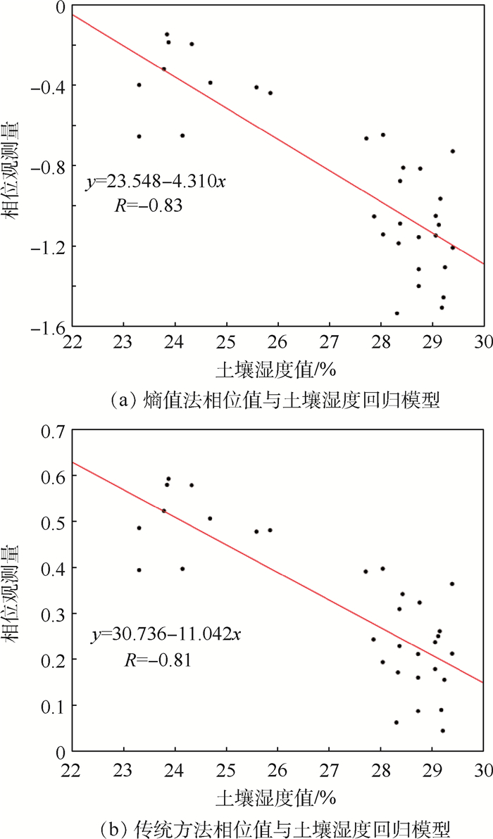
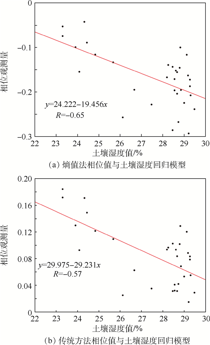
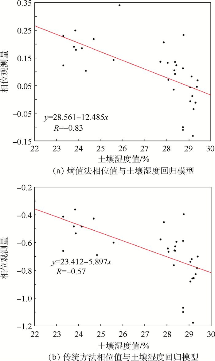
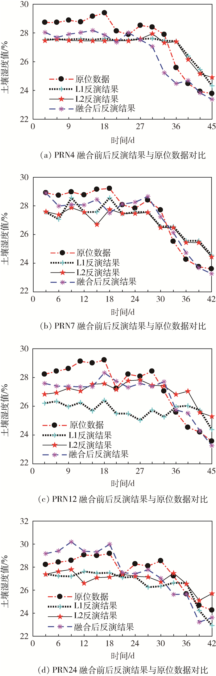
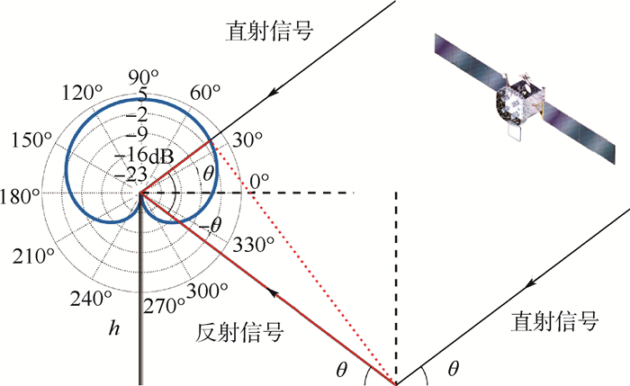
At present, the study of soil moisture inversion in the field of global navigation satellite signal-interferometer and reflectometry (GNSS-IR) is only for single frequency deployment. In the paper, we propose a method that uses the entropy method to fuse two frequency to improve the accuracy of soil moisture inversion. First, the spectrum analysis method is used to analyze the oscillation frequency of the signal-to-noise ratio (SNR) sequence of each frequency point, and calculate the corresponding equivalent antenna height. The different frequency phase of SNR sequence can be solved by least square method. Then, the phase observation of two frequencies is fused by the entropy method. Finally, an empirical model was established by using the fusion results and the measured soil moisture to achieve soil moisture inversion. The method was verified by global positioning system (GPS) SNR ratio data obtained in frequency L1 and L2 by ground-based observation experiments. The results show that the average standard deviation of the L1 and L2 inversion results after dual frequency fusion is 0.6%, which is 64.73% higher than the L1 frequency inversion results and 32.12% higher than the L2 frequency inversion results. And the RMSE is 0.37%, 72.8% lower than L1 frequency and 73.4% lower than L2 frequency.

| [1] |
AUBER J C, BIBAUT A, RIGAL J M.Characterization of multipath on land and sea at GPS frequencies[C]//Proceedings of the 7th International Technical Meeting of the Satellite Division of the Institute of Navigation(ION GPS 1994), 1994: 1155-1171.
|
| [2] |
GARRISON J L, KATZBERG S, HILL M.Effect of sea roughness on bistatically scattered range coded singals from the global positioning system[J].Geophysical Research Letters, 1998, 25(13):2257-2260. doi: 10.1029/98GL51615
|
| [3] |
KOMJATHY A, ZAVOROTNY V, AXELRAD P, et al.GPS signal scattering from sea surface: Comparison between experimental data and theoretical model[C]//Proceeding of the 5th International Conference on Marine and Coastal Environments, 1998: 1-10.
|
| [4] |
丁金才.GPS气象学及其应用[M].北京:气象出版社, 2009.
DING J C.GPS meteorology and its application[M].Beijing:Meteorological Publishing Press, 2009(in Chinese).
|
| [5] |
RODRIGUEZ-ALVAREZ N, BOSCH-LLUIS X, CAMPS A, et al.Review of crop growth and soil moisture monitoring from a ground-based instrument implementing the interference pattern GNSS-R technique[J].Radio Science, 2016, 46(6):1-11. http://www.wanfangdata.com.cn/details/detail.do?_type=perio&id=68097a229aa3a5abe54b0a850ebe0ded
|
| [6] |
CAMPS A, PARK H, PABLOS M, et al.Soil moisture and vegetation impact in GNSS-R TechDemoSat-1 observations[C]//36th IEEE International Geoscience and Remote Sensing Symposium.NJ: IEEE Press, 2016: 1982-1984. https://www.researchgate.net/publication/309773062_Soil_moisture_and_vegetation_impact_in_GNSS-R_TechDemosat-1_observations
|
| [7] |
PALOSCIA S, MACELLONI G, SANTI E, et al.A multifrequency algorithm for the retrieval of soil moisture on a large scale using microwave data from SMMR and SSM/I satellites[J].IEEE Transactions on Geoscience and Remote Sensing, 2001, 39(8):1655-1661. doi: 10.1109/36.942543
|
| [8] |
NIEVINSKI F G.Forward and inverse modeling of GPS multipath for snow monitoring[D].Boulder: University of Colorado Boulder, 2013. https://www.researchgate.net/publication/258848060_Forward_and_Inverse_Modeling_of_GPS_Multipath_for_Snow_Monitoring
|
| [9] |
RODRIGUEZ-ALVAREZ N, AGUASCA A, VALENCIA E, et al.Snow thickness monitoring using GNSS measurements[J].IEEE Geoscience and Remote Sensing Letters, 2012, 9(6):1109-1113. doi: 10.1109/LGRS.2012.2190379
|
| [10] |
LARSON K M, NIEVINSKI F G.GPS snow sensing:Results from the earth scope plate boundary observatory[J].GPS Solutions, 2013, 17(1):41-52. doi: 10.1007/s10291-012-0259-7
|
| [11] |
BINBIN L I, ZHANG Y, YANG S, et al.Snow depth altimetry using GNSS signal with single antenna[J].GNSS World of China, 2016, 41(6):37-41. http://www.wanfangdata.com.cn/details/detail.do?_type=perio&id=qqdwxt201606008
|
| [12] |
LARSON K M, SMALL E E, GUTMANN E, et al.Using GPS multipath to measure soil moisture fluctuations:Initial results[J].GPS Solutions, 2008, 12(3):173-177. doi: 10.1007/s10291-007-0076-6
|
| [13] |
ALONSO-ARROYO A, CAMPS A, AUGUASCA A, et al.Improving the accuracy of soil moisture retrievals using the phase difference of the dual-polarization GNSS-R interference patterns[J].IEEE Geoscience and Remote Sensing Letters, 2014, 11(12):2090-2094. doi: 10.1109/LGRS.2014.2320052
|
| [14] |
ROUSSEL N, FRAPPART F, RAMILLIEN G, et al.Detection of soil moisture variations using GPS and GLONASS SNR data for elevation angles ranging from 2° to 70°[J].IEEE Journal of Selected Topics in Applied Earth Observations and Remote Sensing, 2016, 9(10):4781-4794. doi: 10.1109/JSTARS.2016.2537847
|
| [15] |
YANG T, WAN W, CHEN X W, et al.Using BDS SNR observations to measure near-surface soil moisture fluctuations:Results from low vegetated surface[J].IEEE Geoscience and Remote Sensing Letters, 2017, 14(8):1308-1312. doi: 10.1109/LGRS.2017.2710083
|
| [16] |
敖敏思, 朱建军, 胡友健, 等.利用SNR观测值进行GPS土壤湿度监测[J].武汉大学学报(信息科学版), 2015, 40(1):117-120. http://d.old.wanfangdata.com.cn/Periodical/whchkjdxxb201501019
AO M S, ZHU J J, HU Y J, et al.Comparative experiments on soil moisture monitoring with GPS SNR observations[J].Geomatics and Information Science of Wuhan University, 2015, 40(1):117-120(in Chiense). http://d.old.wanfangdata.com.cn/Periodical/whchkjdxxb201501019
|
| [17] |
徐晓悦, 郑南山, 谭兴龙.GPS-R技术辅助的土壤水含量变化监测[J].测绘科学技术学报, 2015, 32(5):465-468. doi: 10.3969/j.issn.1673-6338.2015.05.006
XU X Y, ZHENG N S, TAN X L.Monitoring of soil moisture fluctuation in mining areas based on GPS-R[J].Journal of Geomatics Science and Technology, 2015, 32(5):465-468(in Chiense). doi: 10.3969/j.issn.1673-6338.2015.05.006
|
| [18] |
汉牟田, 张波, 杨东凯, 等.利用GNSS干涉信号振荡幅度反演土壤湿度[J].测绘学报, 2016, 45(11):1293-1300. doi: 10.11947/j.AGCS.2016.20160145
HAN M T, ZHANG B, YANG D K, et al.Soil moisture retrieval utilizing GNSS interference signal amplitude[J].Acta Geodaetica et Cartographica Sinica, 2016, 45(11):1293-1300(in Chiense). doi: 10.11947/j.AGCS.2016.20160145
|
| [19] |
YAN S H, ZHAO F, CHEN N C, et al.Soil moisture estimation based on BeiDou B1 interference signal analysis[J].Science China Earth Sciences, 2016, 59(12):2427-2440. doi: 10.1007/s11430-015-0013-7
|
| [20] |
金双根, 张勤耘, 钱晓东.全球导航卫星系统反射测量(GNSS+R)最新进展与应用前景[J].测绘学报, 2017, 46(10):1389-1398. doi: 10.11947/j.AGCS.2017.20170282
JIN S G, ZHANG Q Y, QIAN X D.New progress and application prospects of global navigation satellite system reflectometry(GNSS+R)[J].Acta Geodaetica et Cartographica Sinica, 2017, 46(10):1389-1398(in Chiense). doi: 10.11947/j.AGCS.2017.20170282
|
| [21] |
段睿, 张波, 汉牟田, 等.SVRM方法的单天线GNSS-R土壤湿度反演[J].导航定位学报, 2018, 6(1):34-39. http://d.old.wanfangdata.com.cn/Periodical/dhdwxb201801007
DUAN R, ZHANG B, HAN M T, et al.Inversion of soil moisture with singal-antenna GNSS-R signal using SVRM[J].Journal of Navigation and Positioning, 2018, 6(1):34-39(in Chiense). http://d.old.wanfangdata.com.cn/Periodical/dhdwxb201801007
|
| [22] |
杨磊.GNSS-R农田土壤湿度反演方法研究[D].泰安: 泰安农业大学, 2017. http://www.cqvip.com/QK/90069X/201801/674427807.html
YANG L.Study of GNSS-R cropland soil moisture retrieval method[D].Tai'an: Shandong Agricultural University, 2017(in Chiense). http://www.cqvip.com/QK/90069X/201801/674427807.html
|
| [23] |
王富喜, 毛爱华, 李赫龙, 等.基于熵值法的山东省城镇化质量测度及空间差异分析[J].地理科学, 2013, 33(11):1323-1329. http://www.wanfangdata.com.cn/details/detail.do?_type=perio&id=dlkx201311006
WANG F X, MAO A H, LI H L, et al.Quality measurement and regional difference of urbanization in shandong province based on the entropy method[J].Scientia Geographica Sinica, 2013, 33(11):1323-1329(in Chiense). http://www.wanfangdata.com.cn/details/detail.do?_type=perio&id=dlkx201311006
|
Figures(9)
Copyright © Journal of Beijing University of Aeronautics and Astronautics
Address: Editorial Department of Journal of Beijing University of Aeronautics and Astronautics, 37 Xueyuan Road, Haidian District, Beijing Post Code: 100191 Email: jbuaa@buaa.edu.cn
Supported by:
Beijing Renhe Information Technology Co., Ltd.


 DownLoad: