| Citation: | NIU Guochen, WANG Yu. Unmanned vehicle positioning and mapping method based on multi-constraint factor graph optimization[J]. Journal of Beijing University of Aeronautics and Astronautics, 2021, 47(2): 306-314. doi: 10.13700/j.bh.1001-5965.2020.0212(in Chinese)

|
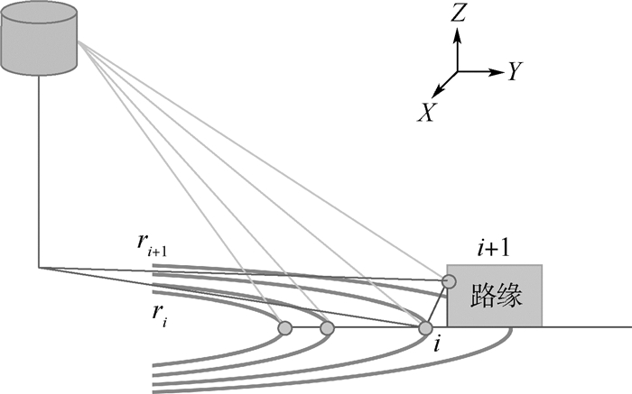
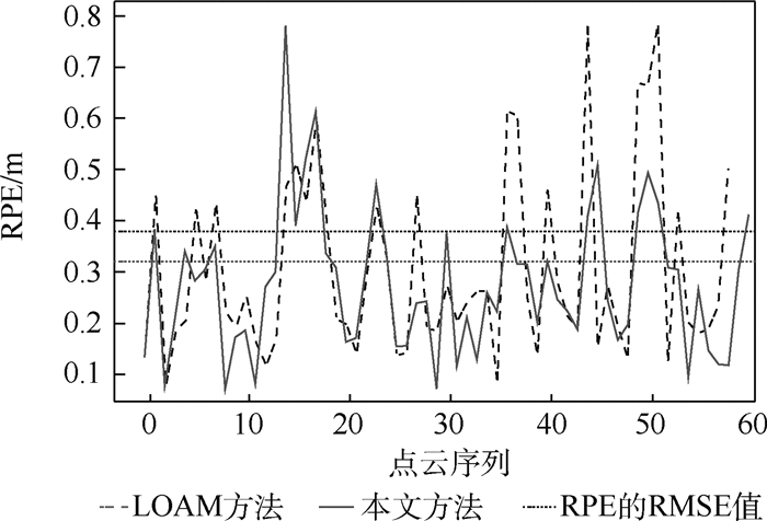
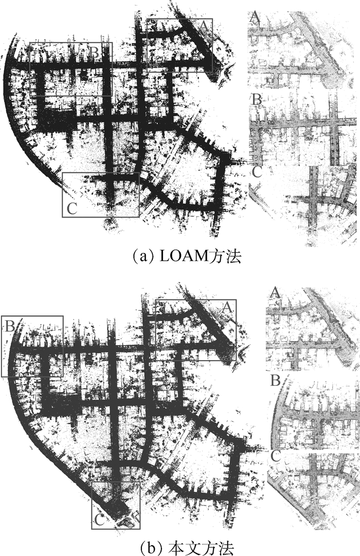
Aimed at the problem that the current low-speed positioning system of unmanned vehicle extremely relies on the Global Navigation Satellite System (GNSS), which has low positioning accuracy, large drift error and serious environmental impact, a low-cost and high-precision positioning and mapping method is proposed. This method is based on the three-dimensional laser Simultaneous Localization and Mapping(SLAM) technology. First, the point cloud Principal Component Analysis (PCA) is used to implement laser odometry based on feature matching. Then, the GNSS location information, ground plane and clustering feature of point cloud obtained by point cloud segmentation and clustering are added to the graph optimization framework as pose constraints, and the cumulative error of the laser odometry is eliminated. Finally, an optimal pose and large-scale scenes point cloud map is obtained to achieve the unmanned vehicles' position navigation. The proposed SLAM algorithm is evaluated using the KITTI dataset containing large outdoor urban street environments. The results show that the positioning deviation of this system can be controlled below 1.5 m at a movement distance of 3 km, and both in terms of local accuracy and global consistency, it is superior to other odometry systems and provides new ideas for the positioning of unmanned vehicles.

| [1] |
李宏刚, 王云鹏, 廖亚萍, 等. 无人驾驶矿用运输车辆感知及控制方法[J]. 北京航空航天大学学报, 2019, 45(11): 2335-2344. doi: 10.13700/j.bh.1001-5965.2019.0521
LI H G, WANG Y P, LIAO Y P, et al. Perception and control method of driverless mining vehicle[J]. Journal of Beijing University of Aeronautics and Astronautics, 2019, 45(11): 2335-2344(in Chinese). doi: 10.13700/j.bh.1001-5965.2019.0521
|
| [2] |
宁海宽. 复杂环境下基于地图的多传感器融合低速无人车定位[D]. 武汉: 华中科技大学, 2019: 16-23.
NING H K.Map-based localization of self-driving car using multi-sensor in diverse city scenes[D].Wuhan: Huazhong University of Science and Technology, 2019: 16-23(in Chinese).
|
| [3] |
SUZUKI T, INOUE D C, AMANO Y S H, et al.Robust UAV position and attitude estimation using multiple GNSS receivers for laser based 3D mapping[C]//Proceedings of the IEEE/RSJ International Conference on Intelligent Robots and Systems(IROS).Piscataway: IEEE Press, 2019: 4402-4408.
|
| [4] |
ZHANG M, XU X Y, CHEN Y M, et al. A lightweight and accurate localization algorithm using multiple inertial measurement units[J]. IEEE Robotics and Automation Letters, 2020, 5(2): 261-264. http://arxiv.org/abs/2010.07450
|
| [5] |
QI H, MOORE J B. Direct Kalman filtering approach for GPS/INS integration[J]. IEEE Transactions on Aerospace and Electronic Systems, 2002, 38(2): 687-693. doi: 10.1109/TAES.2002.1008998
|
| [6] |
YANG S, ZHU X, NIAN X, et al.A robust pose graph approach for city scale LiDAR mapping[C]//Proceedings of the IEEE/RSJ International Conference on Intelligent Robots and Systems(IROS).Piscataway: IEEE Press, 2018: 1175-1182.
|
| [7] |
WAN G, YANG X, CAI R, et al.Robust and precise vehicle localization based on multi-sensor fusion in diverse city scenes[C]//IEEE International Conference on Robotics and Automation(ICRA).Piscataway: IEEE Press, 2018: 4670-4677.
|
| [8] |
PANG S, KENT D, MORRIS D, et al.FLAME: Feature-likelihood based mapping and localization for autonomous vehicles[C]//Proceedings of the IEEE/RSJ International Conference on Intelligent Robots and Systems(IROS).Piscataway: IEEE Press, 2019: 5312-5319.
|
| [9] |
AHMED S Z, SAPUTRA D B, VERMA S, et al.Sparse-3D lidar outdoor map-based autonomous vehicle localization[C]//Proceedings of the IEEE/RSJ International Conference on Intelligent Robots and Systems(IROS).Piscataway: IEEE Press, 2019: 1614-1619.
|
| [10] |
安平, 王国平, 余佳东, 等. 一种高效准确的视觉SLAM闭环检测算法[J]. 北京航空航天大学学报, 2021, 47(1): 24-30. doi: 10.13700/j.bh.1001-5965.2019.0642
AN P, WANG G P, YU J D, et al. An efficient and accurate visual SLAM loop closure detection algorithm[J]. Journal of Beijing University of Aeronautics and Astronautics, 2021, 47(1): 24-30(in Chinese). doi: 10.13700/j.bh.1001-5965.2019.0642
|
| [11] |
SAPUTRA M R U, MARKHAM A, TRIGONI N. Visual SLAM and structure from motion in dynamic environments: A survey[J]. ACM Computing Surveys, 2018, 51(2): 1-36.
|
| [12] |
ZHANG J, SINGH S. Low-drift and real-time lidar odometry and mapping[J]. Autonomous Robots, 2017, 41(2): 401-416. doi: 10.1007/s10514-016-9548-2
|
| [13] |
SHAN T, ENGLOT B.Lego-LOAM: Lightweight and ground-optimized lidar odometry and mapping on variable terrain[C]//Proceedings of the IEEE/RSJ International Conference on Intelligent Robots and Systems(IROS).Piscataway: IEEE Press, 2018: 4758-4765.
|
| [14] |
JI X, ZUO L, ZHANG C, et al.LLOAM: LiDAR odometry and mapping with loop-closure detection based correction[C]//Proceedings of the IEEE International Conference on Mechatronics and Automation (ICMA).Piscataway: IEEE Press, 2019: 2475-2480.
|
| [15] |
DESCHAUD J E.IMLS-SLAM: Scan-to-model matching based on 3D data[C]//IEEE International Conference on Robotics and Automation(ICRA).Piscataway: IEEE Press, 2018: 2480-2485.
|
| [16] |
CHEN S W, NARDARI G V, LEE E S, et al. SLOAM: Semantic lidar odometry and mapping for forest inventory[J]. IEEE Robotics and Automation Letters, 2020, 4(2): 612-619. http://ieeexplore.ieee.org/document/8949363
|
| [17] |
GU X J, ZHANG F D, XU J, et al.Graph optimization based Long-distance GPS/IMU integrated navigation[C]//Proceedings of the Chinese Control Conference (CCC).Piscataway: IEEE Press, 2019: 3976-3981.
|
| [18] |
张括嘉, 张云洲, 吕光浩, 等. 基于局部语义拓扑图的视觉SLAM闭环检测[J]. 机器人, 2019, 41(5): 649-659. https://www.cnki.com.cn/Article/CJFDTOTAL-JQRR201905011.htm
ZHANG K J, ZHANG Y Z, LV G H, et al. Loop closure detection based on local semantic topology for visual SLAM system[J]. Robot, 2019, 41(5): 649-659(in Chinese). https://www.cnki.com.cn/Article/CJFDTOTAL-JQRR201905011.htm
|
| [19] |
MA L, KERL C, STUCKLER J, et al.CPA-SLAM: Consistent plane-model alignment for direct RGB-D SLAM[C]//IEEE International Conference on Robotics and Automation (ICRA).Piscataway: IEEE Press, 2016: 1285-1291.
|
| [20] |
于志鹏, 蒋林. 改进3D SLAM算法在移动机器人上的应用[J]. 机械设计与制造, 2020(1): 29-32. https://www.cnki.com.cn/Article/CJFDTOTAL-JSYZ202001009.htm
YU Z P, JIANG L. The application of improved 3D SLAM algorithm in mobiel robot[J]. Mechanical Design and Manufacturing, 2020(1): 29-32(in Chinese). https://www.cnki.com.cn/Article/CJFDTOTAL-JSYZ202001009.htm
|
| [21] |
RENAUD D, ANDREI C, DANIEL D, et al. SegMap: 3D segment mapping using data-driven descriptors[J]. International Journal of Robotics Research, 2020, 39(2-3): 339-355. doi: 10.1177/0278364919863090
|
| [22] |
ZHAO Z R, MAO Y J, DING Y, et al.Visual semantic SLAM with landmarks for large-scale outdoor environment[C]//Accepted by 2019 China Symposium on Cognitive Computing and Hybrid Intelligence(CCHI).Piscataway: IEEE Press, 2019: 149-154.
|
| [23] |
DUBE R, DUGAS D, STUMM E, et al.Segmatch: SegMent based place recognition in 3D point clouds[C]//IEEE International Conference on Robotics and Automation (ICRA).Piscataway: IEEE Press, 2017: 5266-5272.
|
| [24] |
Al A, HE F N, HABIB A. Automated feature-based down-sampling approaches for fine registration of irregular point clouds[J]. Remote Sensing, 2020, 12(71224): 1224. http://www.researchgate.net/publication/340583271_Automated_Feature-Based_Down-Sampling_Approaches_for_Fine_Registration_of_Irregular_Point_Clouds
|
| [25] |
WEINMANN M, JUTZI B, MALLET C. Semantic 3D scene interpretation: A framework combining optimal neighborhood size selection with relevant features[J]. ISPRS Annals of the Photogrammetry, Remote Sensing and Spatial Information Sciences, 2014, 2(3): 181-188. http://adsabs.harvard.edu/abs/2014ISPAn.II3..181W
|

Figures(8) / Tables(2)
Copyright © Journal of Beijing University of Aeronautics and Astronautics
Address: Editorial Department of Journal of Beijing University of Aeronautics and Astronautics, 37 Xueyuan Road, Haidian District, Beijing Post Code: 100191 Email: jbuaa@buaa.edu.cn
Supported by:
Beijing Renhe Information Technology Co., Ltd.


 DownLoad: