


Integrating topography parameters for soil moisture retrieval using CYGNSS on the Qinghai-Tibet Plateau
-
摘要:
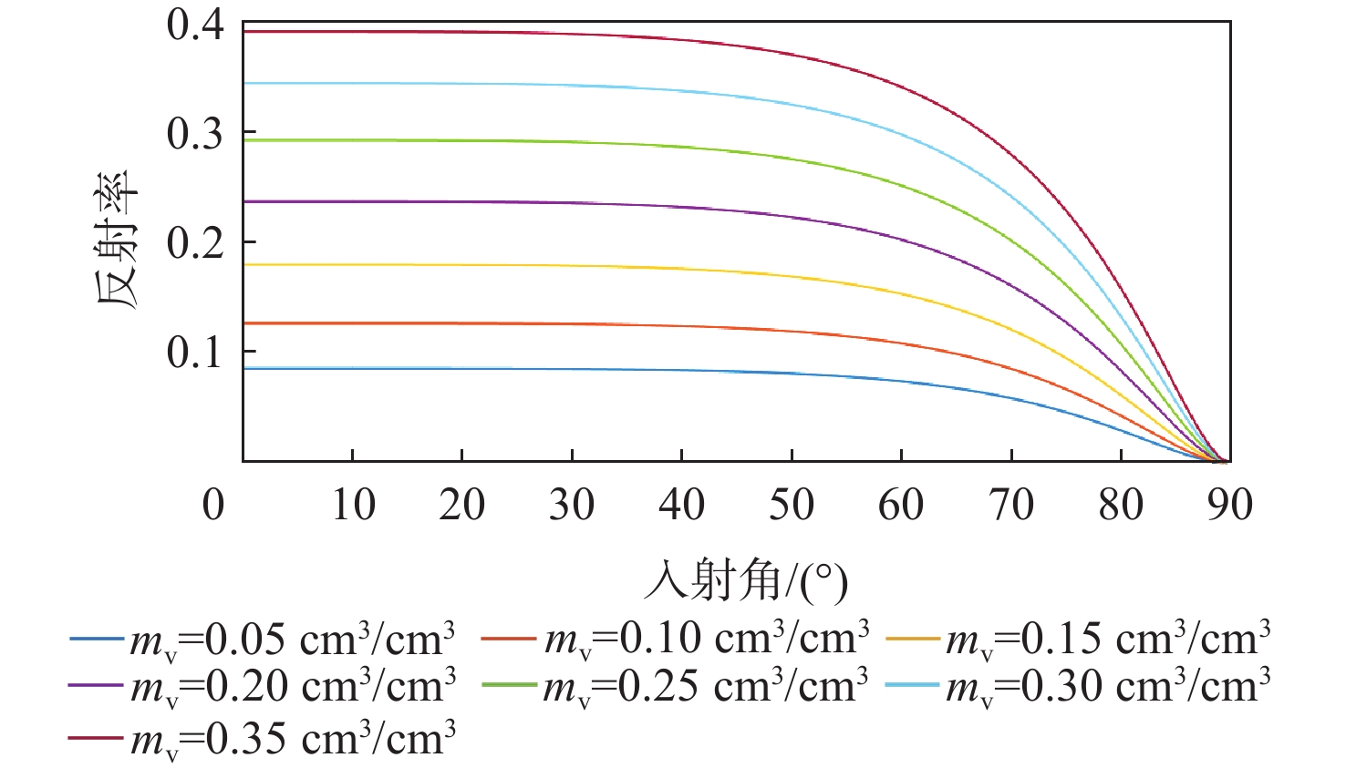
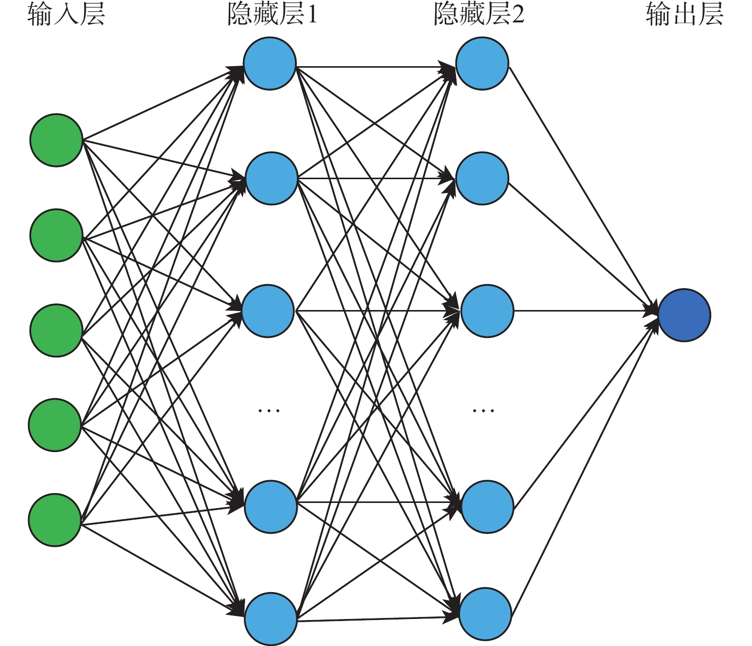
青藏高原的土壤湿度是影响全球大气环流和气候变化的重要因素,旋风全球导航卫星系统(CYGNSS)使用全球导航卫星系统反射信号技术(GNSS-R),为监测青藏高原的土壤湿度提供了新的手段,但高原复杂的地形环境使得CYGNSS的反射率难以被直接用于土壤湿度的反演。基于此,提出了融合修正后CYGNSS反射率、CYGNSS入射角、地形参数(海拔、坡度和地表粗糙度)等5 个特征参数的星载GNSS-R土壤湿度机器学习反演模型。对 CYGNSS 反射率进行发射功率的系统误差修正、地表植被和地表粗糙度衰减误差修正;将修正后反射率等5个参数作为输入特征量,SMAP土壤湿度作为验证数据,使用2020年解冻期(6—9月)数据按5∶5随机分为训练集和验证集,分别建立随机森林(RF)和人工神经网络(ANN)青藏高原土壤湿度反演模型,以2021年解冻期的数据作为测试集,考察模型的泛化能力。随机森林模型的结果优于人工神经网络模型,测试集上反演结果的均方根误差(RMSE)为
0.0586 $ \text{c}{\text{m}}^{\text{3}}\text{/c}{\text{m}}^{\text{3}} $,皮尔逊相关系数为0.7033 ,模型具有较好的泛化性能,且反演得到的青藏高原土壤湿度的空间变化和降水的空间变化趋势相吻合。将CYGNSS土壤湿度与那曲实测土壤湿度进行对比,均方根误差为0.070 $ \text{c}{\text{m}}^{\text{3}}\text{/c}{\text{m}}^{\text{3}} $,具有较高的精度。研究结果表明,融合修正后CYGNSS反射率、CYGNSS入射角和地形参数建立的反演模型能够较为准确地反演青藏高原大范围的土壤湿度。-
关键词:
- 土壤湿度 /
- 青藏高原 /
- 旋风全球导航卫星系统 /
- 反射率修正 /
- 机器学习
Abstract:The soil moisture of the Qinghai-Tibet Plateau plays a crucial role in global atmospheric circulation and climate change. The cyclone global navigation satellite system (CYGNSS), utilizing global navigation satellite system reflectometry (GNSS-R), provides a novel method to monitor soil moisture on the Qinghai-Tibet Plateau; however, the complex topographic environment of the plateau hinders the direct use of CYGNSS reflectivity for soil moisture retrieval. This paper proposes a spaceborne GNSS-R soil moisture machine learning inversion model, which integrates five characteristic parameters: corrected CYGNSS reflectivity, CYGNSS incident angle, and terrain parameters (elevation, slope, surface roughness). First, the CYGNSS reflectance is corrected for two aspects: systematic errors in transmit power, and attenuation induced by surface vegetation and surface roughness. Then, the corrected reflectivity (along with the other four aforementioned parameters) is adopted as input feature quantities, and SMAP soil moisture data is used for model verification. For data partitioning, the 2020 thaw period (June–September) data are randomly split into a training set and a verification set at a 5∶5 ratio. On this basis, two soil moisture inversion models (random forest (RF) and artificial neural network (ANN)) are established specifically for the Qinghai-Tibet Plateau. Use the data from the 2021 thaw period as a test set to examine the generalization ability of the model. The results of the random forest model are better than the artificial neural network model, the inversion result yielding a root mean square error (RMSE) of
0.0586 $ \text{c}{\text{m}}^{\text{3}}\text{/c}{\text{m}}^{\text{3}} $ and Pearson correlation coefficient of0.7033 on the test set. The model exhibits strong generalization performance: the spatial variation of the inverted soil moisture is consistent with the spatial variation trend of precipitation over the Qinghai-Tibet Plateau. Finally, a comparison between the CYGNSS-derived soil moisture and the in-situ measured soil moisture (from Naqu) shows high accuracy, with a RMSE of 0.070 cm3/cm3. The research results show that the inversion model, which integrates corrected CYGNSS reflectance, CYGNSS incident angle, and topography parameters, achieves a more accurate invert of soil moisture in a large range of the Qinghai-Tibet Plateau. -

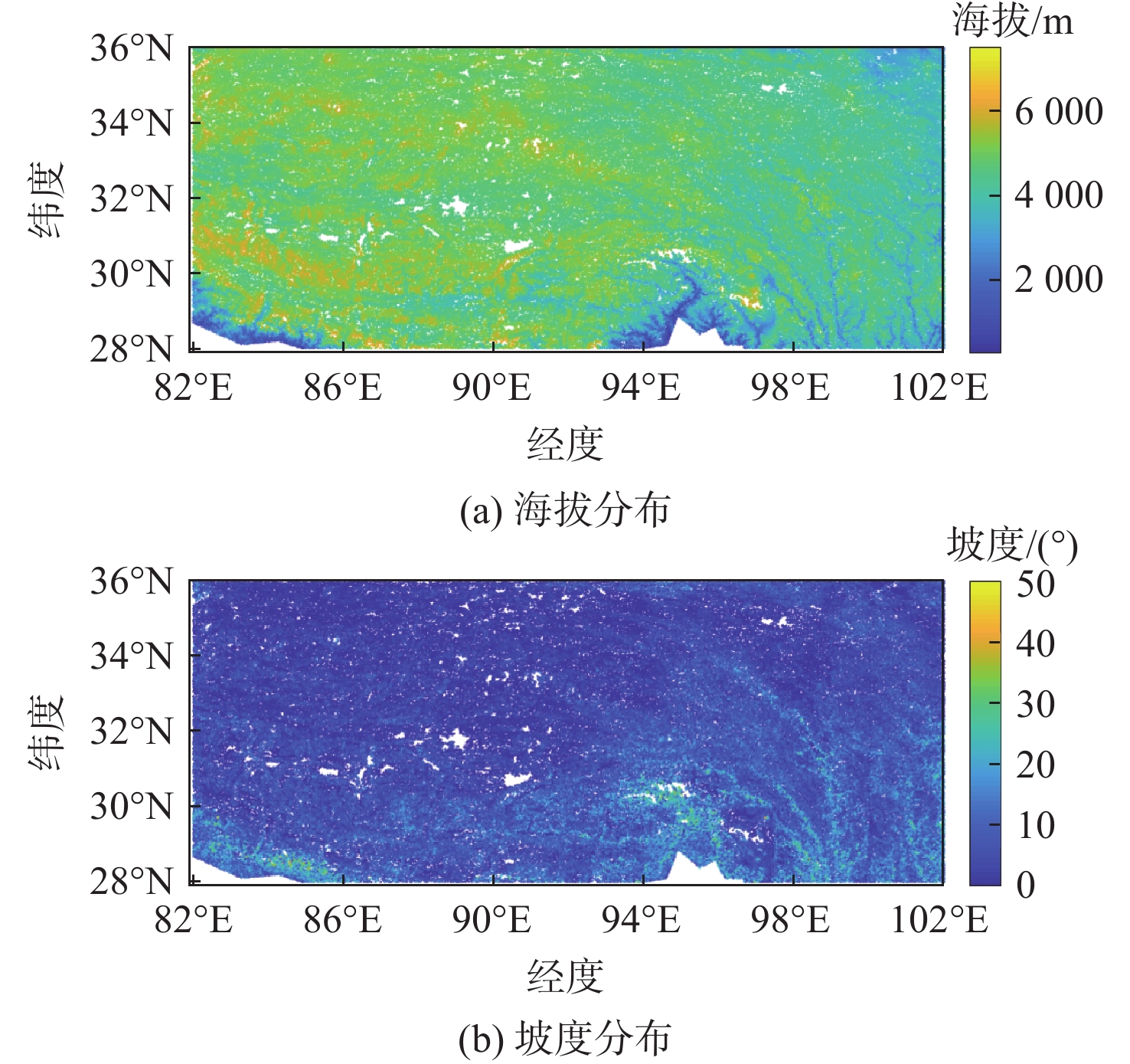
图 3 青藏高原的海拔和坡度分布
Figure 3. Elevation and slope distribution of the Qinghai-Tibet Plateau

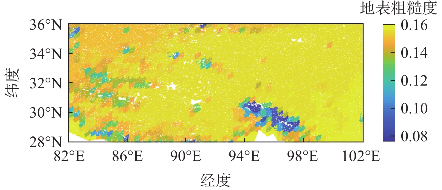
图 4 2020年青藏高原地表粗糙度分布
Figure 4. Surface roughness distribution of the Qinghai-Tibet Plateau in 2020

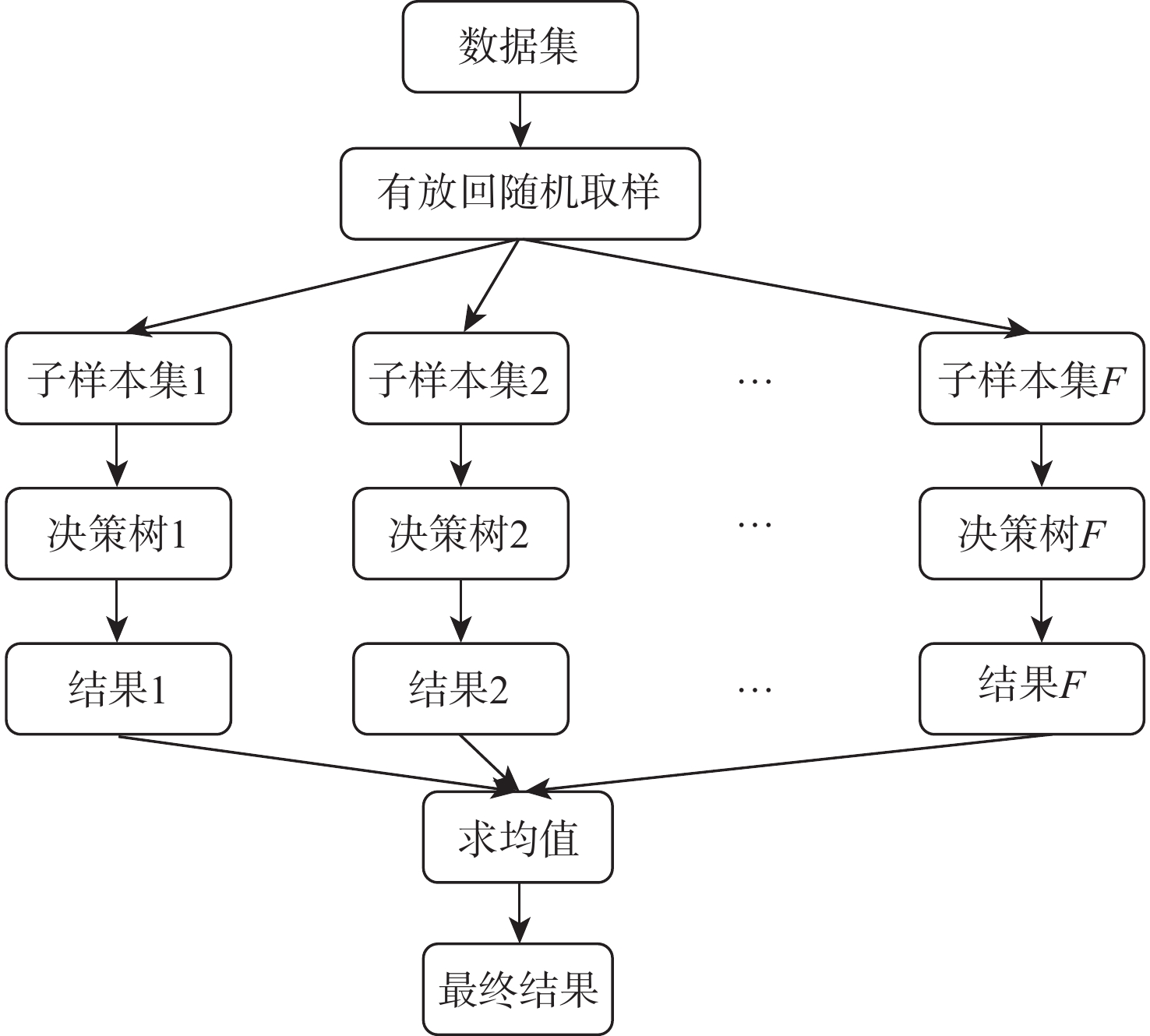
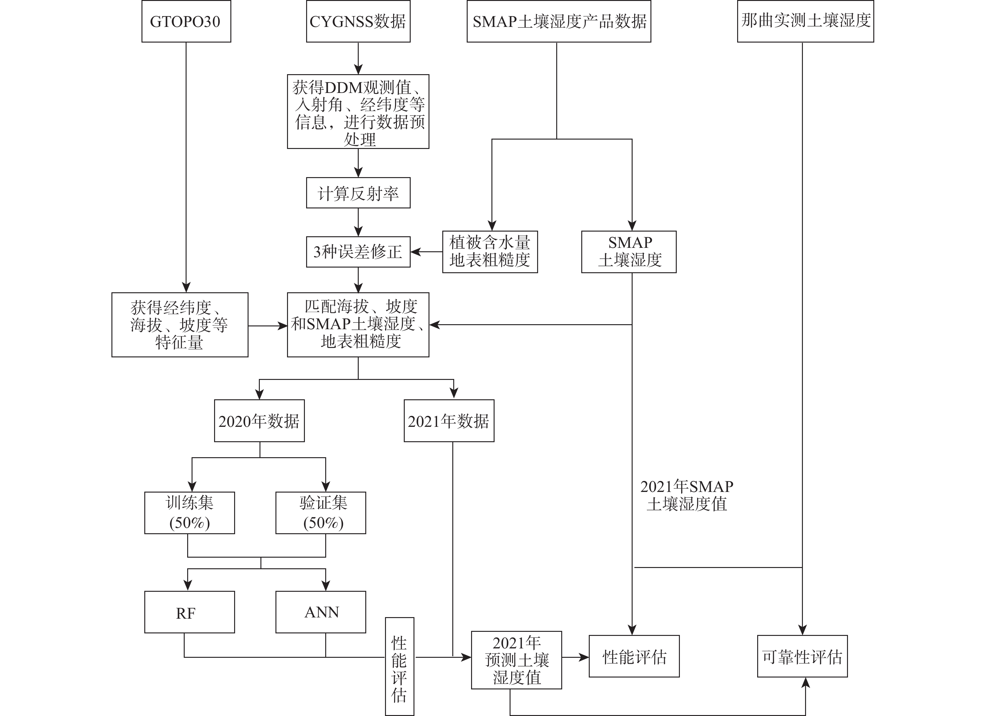
图 7 青藏高原土壤湿度反演流程
Figure 7. Flow chart of soil moisture inversion of the Qinghai-Tibet Plateau

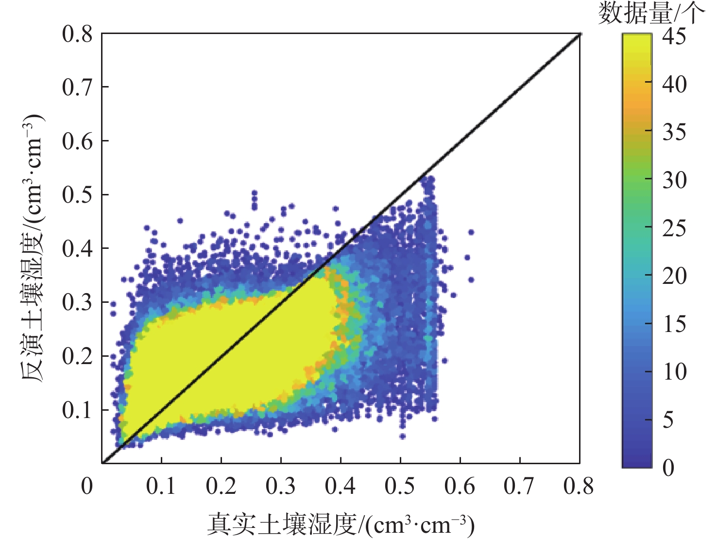
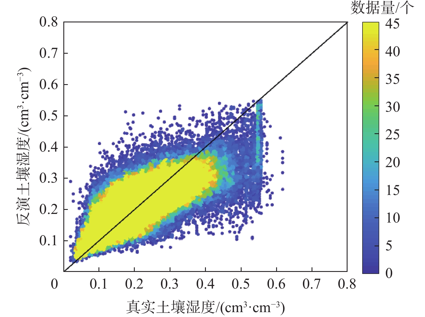
图 10 2020年青藏高原解冻期RF模型对比密度散点图
Figure 10. Density scatter plot of RF model comparison during thawing period of the Qinghai-Tibet Plateau in 2020

图 11 2020年青藏高原解冻期土壤湿度分布
Figure 11. Soil moisture distribution during thawing period of the Qinghai-Tibet Plateau in 2020

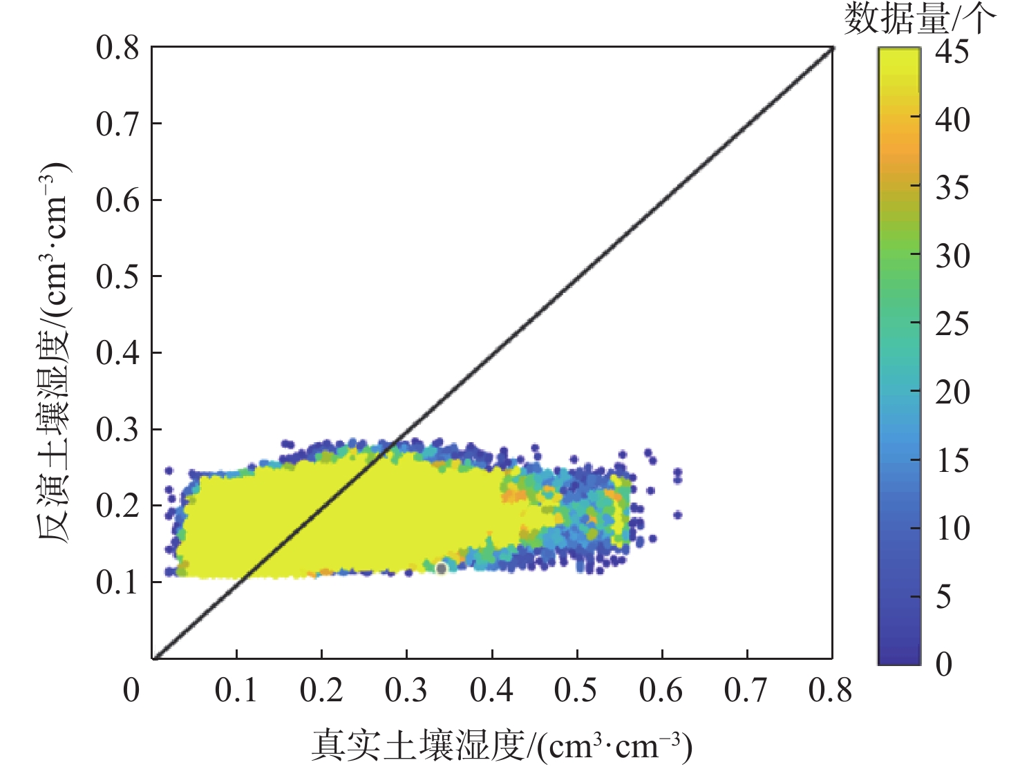
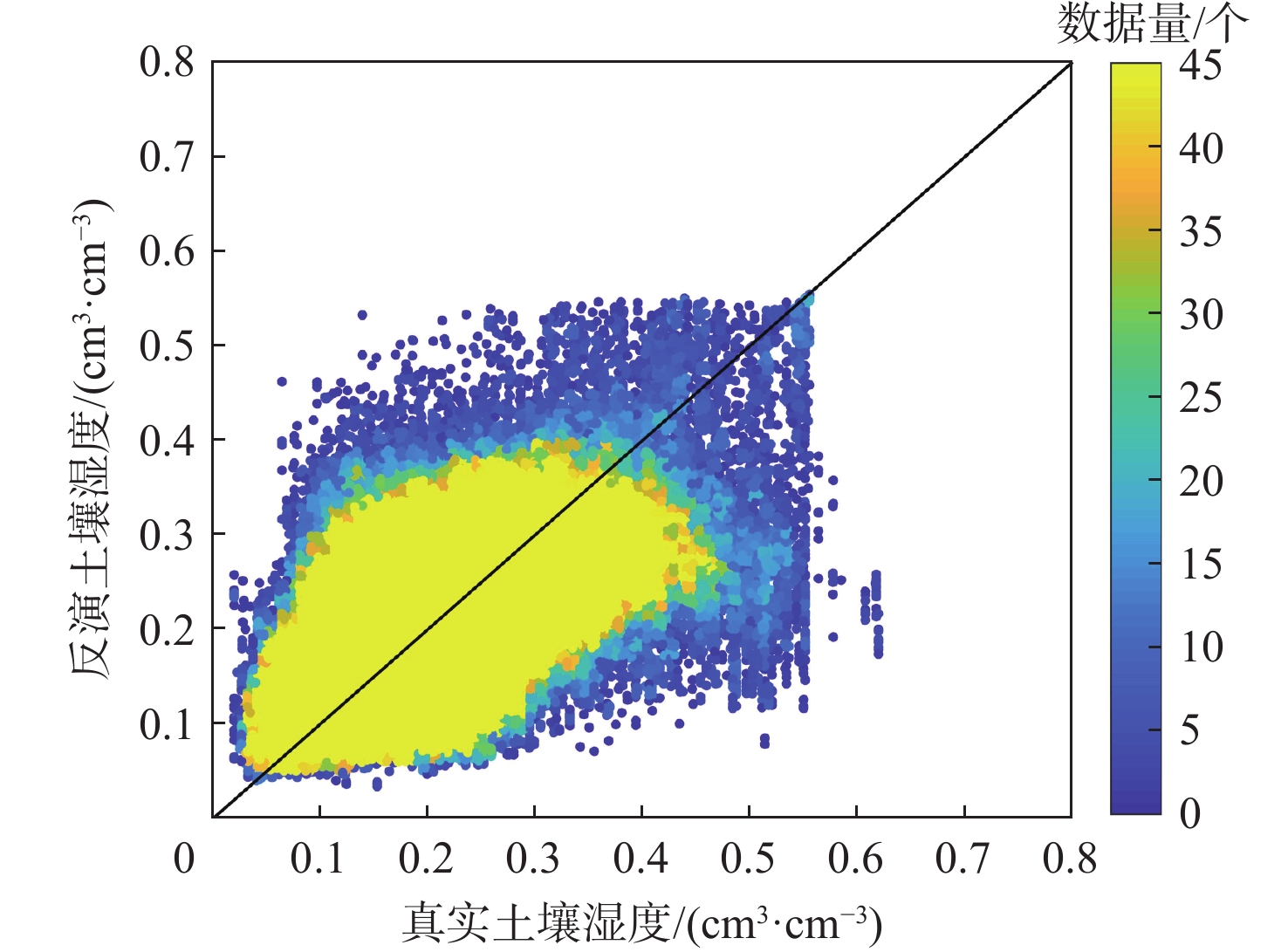
图 12 2021年青藏高原解冻期RF模型对比密度散点图
Figure 12. Density scatter plot of RF model comparison during thawing period of the Qinghai-Tibet Plateau in 2021

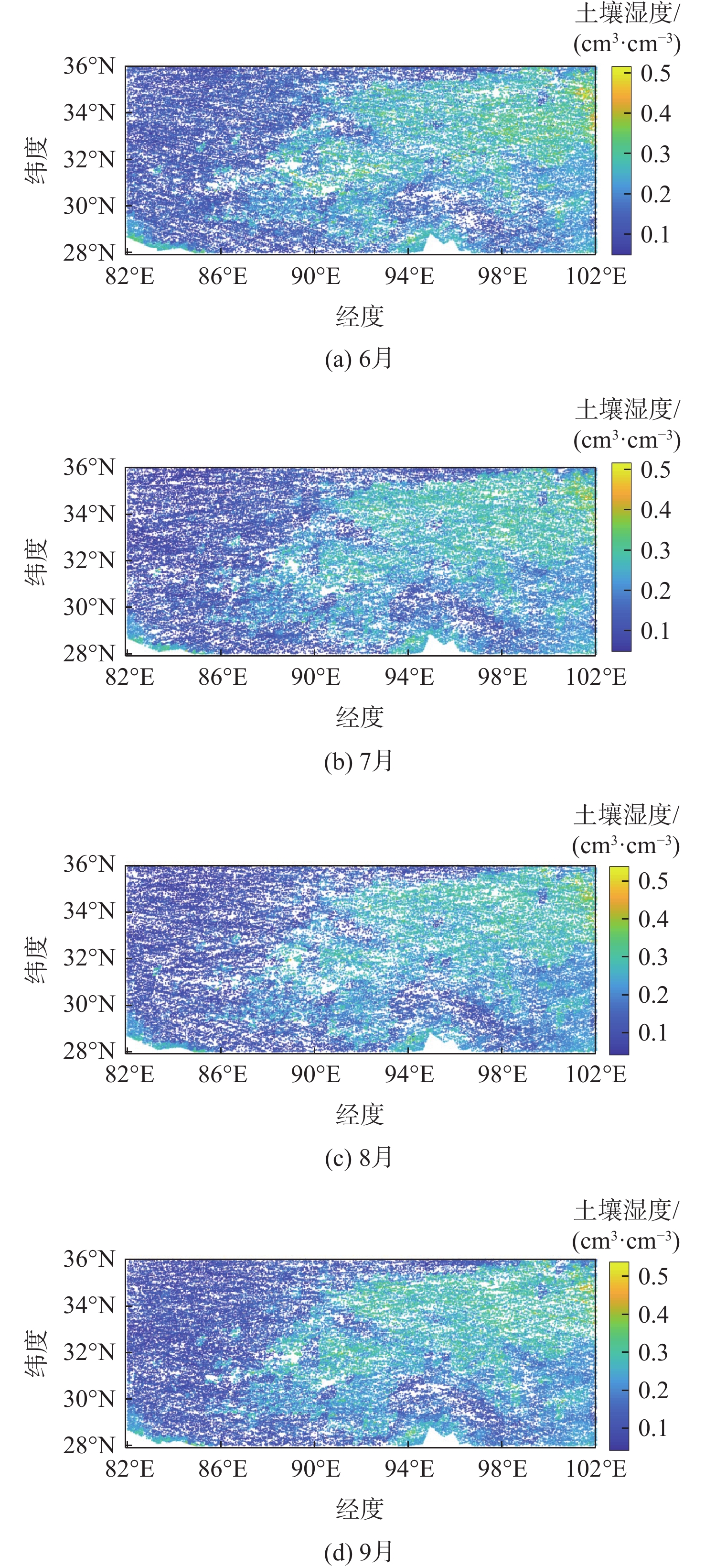
图 13 2021年6—9月的土壤湿度反演结果
Figure 13. Inversion results of soil moisture in June, July, August, and September, 2021

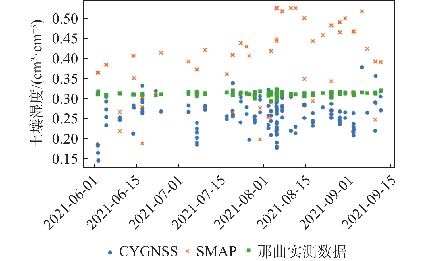
图 14 2021年6月1日至9月15日CYGNSS土壤湿度、SMAP土壤湿度和那曲实测土壤湿度时序图
Figure 14. Time series of CYGNSS soil moisture, SMAP soil moisture, and measured soil moisture from the Naqu observation network from June 1 to September 15, 2021
表 1 CYGNSS数据筛选条件
Table 1. CYGNSS data filtering criteria
数据类型 筛选条件 入射角/(°) 0~65 天线增益/dB >0 信噪比/dB >0 DDM 峰值时延位置 第7~10 个  下载: 导出CSV
表 2 2020年反射率修正前后模型反演结果
Table 2. Model inversion results before and after reflectivity correction in 2020
模型 输入特征量 $ {E}_{{\mathrm{b}}} $/
(cm3·cm−3)$ {E}_{{\mathrm{rms}}} $/
(cm3·cm−3)R RF 未修正的反射率$ \varGamma $和入射角 − 0.0002 0.0941 0.0944 修正后的反射率$ {\varGamma }_{3} $和入射角 0.0001 0.0675 0.6901 ANN 未修正的反射率$ \varGamma $和入射角 − 0.0001 0.1450 0.1612 修正后的反射率$ {\varGamma }_{3} $和入射角 − 0.0011 0.0814 0.3952
下载: 导出CSV
模型 CYGNSS特征量 融合特征量 $ {E}_{{\mathrm{b}}} $/
(cm3·cm−3)$ {E}_{{\mathrm{rms}}} $/
(cm3·cm−3)R RF 修正后的反射
率、入射角海拔、坡度、
地表粗糙度− 0.0007 0.0454 0.8614 ANN 修正后的反射
率、入射角海拔、坡度、
地表粗糙度− 0.0009 0.0584 0.7517 文献[16] 反射率、经度、
纬度、时间地表粗糙度、
NDVI、高程、
地物类型0.010 0.030 0.857
下载: 导出CSV
表 4 RF模型2021年解冻期泛化结果与文献[16] 2019年泛化结果
Table 4. Generalization results of RF model for 2021 thawing period and Ref. [16] for 2019
时间 $ {E}_{{\mathrm{b}}} $/(cm3·cm−3) $ {E}_{{\mathrm{rms}}} $/(cm3·cm−3) R 2021年6月 − 0.012 0.0589 0.7030 2021年7月 0.0021 0.0583 0.6792 2021年8月 0.0079 0.0618 0.6832 2021年9月 − 0.0096 0.0551 0.7612 2021年6—9月 − 0.0032 0.0586 0.7033 2019年(文献[16]) 0.010 0.034 0.743
下载: 导出CSV
表 5 不同区间的泛化精度与对应的数据量
Table 5. Generalization accuracy and corresponding data volume of different intervals
区间号 土壤湿度范围/
(cm3·cm−3)$ {E}_{{\mathrm{rms}}} $/(cm3·cm−3) 训练集数量 测试集数量 1 (0,0.1] 0.0533 48729 85804 2 (0.1,0.2] 0.0522 102098 251642 3 (0.2,0.3] 0.0534 79370 167619 4 (0.3,0.4] 0.0817 20349 36311 5 (0.4,0.5] 0.1573 3775 6055 6 (0.5,0.6] 0.2353 1567 1393 7 (0.6,0.7] 0.3971 3 32
下载: 导出CSV
-
[1] 樊威伟, 胡泽勇, 荀学义, 等. 青藏高原季风演变及其气候效应综述[J]. 高原气象, 2021, 40(6): 1294-1303.FAN W W, HU Z Y, XUN X Y, et al. Review of Qinghai-Xizang Plateau monsoon’s evolution and climatic effects[J]. Plateau Meteorology, 2021, 40(6): 1294-1303(in Chinese). [2] DENTE L, VEKERDY Z, WEN J, et al. Maqu network for validation of satellite-derived soil moisture products[J]. International Journal of Applied Earth Observation and Geoinformation, 2012, 17: 55-65. [3] KARTHIKEYAN L, PAN M, WANDERS N, et al. Four decades of microwave satellite soil moisture observations. Part 1. A review of retrieval algorithms[J]. Advances in Water Resources, 2017, 109: 106-120. [4] 杨婷, 陈秀万, 万玮, 等. 基于光学与被动微波遥感的青藏高原地区土壤水分反演[J]. 地球物理学报, 2017, 60(7): 2556-2567.YANG T, CHEN X W, WAN W, et al. Soil moisture retrieval in the Tibetan Plateau using optical and passive microwave remote sensing data[J]. Chinese Journal of Geophysics, 2017, 60(7): 2556-2567(in Chinese). [5] 程渊. 基于集成学习的土壤含水量遥感反演研究[D]. 成都: 电子科技大学, 2020: 1-80.CHENG Y. Study on remote sensing inversion of soil moisture based on ensemble learning[D]. Chengdu: University of Electronic Science and Technology of China, 2020: 1-80(in Chinese). [6] GARRISON J L, KURUM M, NOLD B, et al. Remote sensing of root-zone soil moisture using I- and P-band signals of opportunity: instrument validation studies[C]//Proceedings of the IEEE International Geoscience and Remote Sensing Symposium. Piscataway: IEEE Press, 2018: 8305-8308. [7] 张云, 张丹丹, 孟婉婷, 等. CYGNSS/SMAP数据融合半经验模型的土壤湿度反演[J]. 北京航空航天大学学报, 2023, 49(11): 2873-2882.ZHANG Y, ZHANG D D, MENG W T, et al. Soil moisture retrieval using CYGNSS/SMAP data fusion semi-empirical model[J]. Journal of Beijing University of Aeronautics and Astronautics, 2023, 49(11): 2873-2882(in Chinese). [8] ZHANG Y, YIN J W, YANG S H, et al. High wind speed inversion model of CYGNSS sea surface data based on machine learning[J]. Remote Sensing, 2021, 13(16): 3324. [9] ZHANG Y, LU Q, JIN Q, et al. Global sea surface height measurement from CYGNSS based on machine learning[J]. IEEE Journal of Selected Topics in Applied Earth Observations and Remote Sensing, 2023, 16: 841-852. [10] 涂晋升. 利用GNSS-R观测数据反演土壤湿度[D]. 成都: 西南交通大学, 2019: 10-30.TU J S. Inversion of soil moisture using GNSS-R observation data[D]. Chengdu: Southwest Jiaotong University, 2019: 10-30(in Chinese). [11] CHEW C, SHAH R, ZUFFADA C, et al. Demonstrating soil moisture remote sensing with observations from the UK TechDemoSat-1 satellite mission[J]. Geophysical Research Letters, 2016, 43(7): 3317-3324. [12] CLARIZIA M P, PIERDICCA N, COSTANTINI F, et al. Analysis of CYGNSS data for soil moisture retrieval[J]. IEEE Journal of Selected Topics in Applied Earth Observations and Remote Sensing, 2019, 12(7): 2227-2235. [13] WAN W, JI R, LIU B J, et al. A two-step method to calibrate CYGNSS-derived land surface reflectivity for accurate soil moisture estimations[J]. IEEE Geoscience and Remote Sensing Letters, 2020, 19: 2500405. [14] SENYUREK V, LEI F N, BOYD D, et al. Machine learning-based CYGNSS soil moisture estimates over ISMN sites in CONUS[J]. Remote Sensing, 2020, 12(7): 1168. [15] CHEW C C, SMALL E E. Soil moisture sensing using spaceborne GNSS reflections: comparison of CYGNSS reflectivity to SMAP soil moisture[J]. Geophysical Research Letters, 2018, 45(9): 4049-4057. [16] 胡羽丰, 汪吉, 李振洪, 等. 基于星载GNSS-R获取川藏交通廊道沿线地表土壤湿度[J]. 地球科学, 2022, 47(6): 2058-2068.HU Y F, WANG J, LI Z H, et al. Land surface soil moisture along Sichuan-Tibet traffic corridor retrieved by spaceborne global navigation satellite system reflectometry[J]. Earth Science, 2022, 47(6): 2058-2068(in Chinese). [17] 马龙, 李颖. 从GTOPO30到SRTM DEM精度研究: 以西藏为例[J]. 水土保持通报, 2006, 26(5): 71-74.MA L, LI Y. Study on accuracy of GTOPO30 and SRTM DEM: a case study of Tibet[J]. Bulletin of Soil and Water Conservation, 2006, 26(5): 71-74(in Chinese). [18] 荆琛琳. SMAP、CCI和CLDAS土壤湿度产品在青藏高原典型区域的比较验证[J]. 亚热带资源与环境学报, 2020, 15(1): 85-94.JING C L. Comparative evaluation of SMAP & CCI & CLDAS soil moisture products in typical region of Qinghai-Tibet Plateau[J]. Journal of Subtropical Resources and Environment, 2020, 15(1): 85-94(in Chinese). [19] 阳坤, 陈莹莹, 赵龙, 等. 青藏高原中部土壤温湿度多尺度观测网数据集(2010—2021)[DB/OL]. (2021-12-27)[2023-12-01]. https://data.tpdc.ac.cn/en/data/b6269aeb-8b44-4d03-b514-2c804c2cfc26/.YANG K, CHEN Y Y, ZHAO L, et al. The multiscale observation network of soil temperature and moisture on the central Tibetan Plateau (2010—2021) [DB/OL]. (2021-12-27)[2023-12-01]. https://data.tpdc.ac.cn/en/data/b6269aeb-8b44-4d03-b514-2c804c2cfc26/(in Chinese). [20] STILLA D, ZRIBI M, PIERDICCA N, et al. Desert roughness retrieval using CYGNSS GNSS-R data[J]. Remote Sensing, 2020, 12(4): 743. [21] CHEW C, SMALL E. Description of the UCAR/CU soil moisture product[J]. Remote Sensing, 2020, 12(10): 1558. [22] BINDLISH R, BARROS A P. Parameterization of vegetation backscatter in radar-based, soil moisture estimation[J]. Remote Sensing of Environment, 2001, 76(1): 130-137. [23] CHOUDHURY B J, SCHMUGGE T J, CHANG A, et al. Effect of surface roughness on the microwave emission from soils[J]. Journal of Geophysical Research: Oceans, 1979, 84(C9): 5699-5706. [24] CARRENO-LUENGO H, LUZI G, CROSETTO M. First evaluation of topography on GNSS-R: an empirical study based on a digital elevation model[J]. Remote Sensing, 2019, 11(21): 2556. [25] 乔莹莹. 基于数值预测的机器学习相关算法综述[J]. 安阳工学院学报, 2017, 16(4): 71-74.QIAO Y Y. Summarization of machine learning based on numerical prediction[J]. Journal of Anyang Institute of Technology, 2017, 16(4): 71-74(in Chinese). [26] 王静. 青藏高原土壤湿度的时空特征及对长江流域夏季降水的影响[D]. 南京: 南京信息工程大学, 2018: 25-40.WANG J. Temporal and spatial characteristics of soil moisture in Qinghai-Tibet Plateau and its influence on summer precipitation in Yangtze River basin[D]. Nanjing: Nanjing University of Information Science & Technology, 2018: 25-40(in Chinese). [27] 黄凌昕, 陈婕, 阳坤, 等. 现代青藏高原亚洲夏季风气候北界及其西风区和季风区划分[J]. 中国科学: 地球科学, 2023, 53(4): 866-878.HUANG L X, CHEN J, YANG K, et al. The northern boundary of the Asian summer monsoon and division of westerlies and monsoon regimes over the Tibetan Plateau in present-day[J]. Scientia Sinica (Terrae), 2023, 53(4): 866-878(in Chinese). -

 下载:
下载:

 点击查看大图
计量
- 文章访问数: 458
- HTML全文浏览量: 103
- PDF下载量: 152
- 被引次数: 0
