





Methods and influence factors analysis of BeiDou DCB parameter solving based on regional monitoring networks
-
摘要:
北斗三号利用地面区域网及星间链路数据向全球提供导航定位授时服务。目前,北斗三号广播电文轨道、钟差产品已达到较高精度。由于地面区域网对卫星覆盖不足,卫星播发的差分码偏差(DCB)参数精度较其他导航系统参数及事后精密产品存在较大差距。针对上述问题,通过对比分析监测站分布、多全球导航卫星系统(GNSS)组合、解算DCB参数时电离层延迟改正模型等影响因素对区域监测网DCB参数解算精度的影响,提出了区域网估计DCB参数的最优策略。以中国科学院(CAS)发布的DCB产品为参考值,分析其稳定性及一致性,以空间信号测距误差(SISRE)评估DCB产品精度,并利用BDS-3 B1I/B3I双频数据开展单点定位精度验证。结果表明:区域监测网下卫星端DCB相比于CAS采用全球监测网解算卫星端DCB的稳定性下降约2倍,均方根差异约0.4 ns,双系统观测数据解算卫星端DCB的稳定性更优,BDS-3卫星DCB与CAS DCB产品具有更好的一致性。区域监测网下接收机端DCB与CAS DCB产品具有相同的稳定性,其中,双系统观测数据解算的接收机DCB一致性更优。与采用广播星历播发的TGD1参数解算的BDS-3的SISRE结果相比,区域监测网DCB产品对BDS-3的SISRE解算精度提升了47.6%。双频单点定位(SPP)定位结果提升了14.1%,与采用 CAS DCB 产品的提升效果大致相当。
-
关键词:
- 区域监测网 /
- 卫星DCB参数解算 /
- 接收机DCB参数解算 /
- 空间信号测距误差 /
- 单点定位
Abstract:Through the use of intersatellite link data and ground regional networks, the BeiDou-3 system offers worldwide navigation, location, and timing services. Currently, the precision of the BeiDou-3 broadcast ephemeris orbit and clock offset products has reached a high level. However, due to insufficient satellite coverage from the ground regional network, the accuracy of the differential code bias (DCB) parameters broadcast by the satellites shows a significant gap compared to other navigation system parameters and post-processed precision products. In order to tackle these problems, this study examines how the accuracy of DCB parameter estimation in a regional monitoring network is affected by variables like the distribution of monitoring stations, multi-GNSS combinations, and ionospheric delay correction models. It proposes an optimal strategy for estimating DCB parameters within this network. Using the DCB products released by the Chinese Academy of Sciences (CAS) as a reference, the stability and consistency of the DCB products are analyzed, and their accuracy is evaluated through the signal in space range error (SISRE). Single-point positioning accuracy tests are conducted using BDS-3 B1I/B3I dual-frequency data. The findings show that, with a root mean square difference of roughly 0.4 ns, the satellite-end DCB stability in the regional monitoring network is roughly twice as poor as that of the satellite-end DCB determined using the CAS global monitoring network. The stability of satellite-end DCB calculated from dual-system observation data is superior, and the BDS-3 satellite DCB shows better consistency with the CAS DCB products. The receiver-end DCB in the regional monitoring network exhibits the same stability as the CAS DCB products, with dual-system observation data yielding better consistency for the receiver DCB. Compared to the SISRE results of BDS-3 calculated using TGD1 parameters from broadcast ephemeris, the regional monitoring network DCB products enhance the SISRE calculation accuracy for BDS-3 by 47.6%. The dual-frequency SPP positioning results improve by 14.1%, similar to the enhancement effect observed with the CAS DCB products.
-

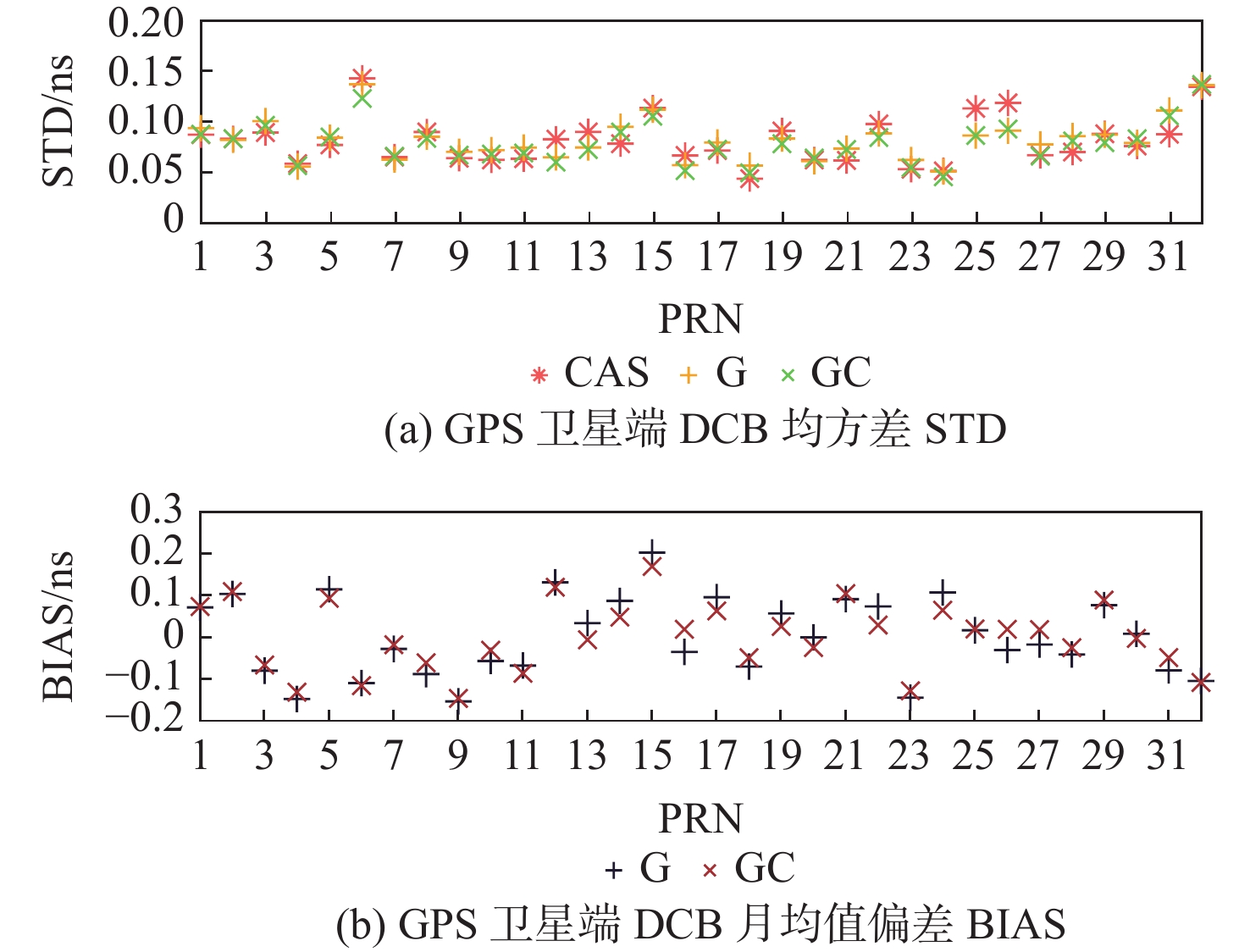
图 1 全球监测网GPS卫星DCB统计结果
Figure 1. Global monitoring network GPS satellite DCB statistics results

图 2 全球监测网BDS卫星DCB统计结果
Figure 2. Global monitoring network BDS satellite DCB statistics results

图 3 全球监测网GPS接收机端DCB统计结果
Figure 3. DCB statistics at the GPS receiver of the global monitoring network

图 4 全球监测网BDS接收机端DCB统计结果
Figure 4. DCB statistics at the BDS receiver of the global monitoring network

图 5 区域监测网GPS卫星端DCB统计结果
Figure 5. DCB statistics of the GPS satellite side of the regional monitoring network

图 6 区域监测网BDS卫星端DCB统计结果
Figure 6. DCB statistics of the BDS satellite side of the regional monitoring network

图 7 区域监测网GPS接收机端DCB统计结果
Figure 7. DCB statistics at the GPS receiver end of the regional monitoring network

图 8 区域监测网BDS接收机端DCB统计结果
Figure 8. DCB statistics at the BDS receiver end of the regional monitoring network

图 9 BDS-3空间信号测距误差SISRE统计结果
Figure 9. BDS-3 spatial signal ranging error SISRE statistical results

图 10 不同基准站BDS-3 B1I B3I双频 SPP定位精度统计
Figure 10. Statistical results of BDS-3 B1I B3I dual-frequency SPP positioning accuracy for different reference stations.
表 1 实际参与DCB参数解算的基准站数量
Table 1. Number of reference stations actually involved in solving DCB parameters
监测网 电离层模型 基准站数量 GPS
L1 L2BDS
B1I B3I全球监测网 球谐函数15×15 233 171  下载: 导出CSV
表 2 区域监测网实际参与DCB参数解算的基准站数量
Table 2. Number of reference stations of the regional monitoring network actually involved in the solving of DCB parameters
监测网 电离层模型 基准站数量 GPS BDS L1 L2 B1I B3I 区域监测网 多项式函数 27 17 球冠谐函数 27 17
下载: 导出CSV
表 3 GPS和BDS相对于CAS卫星端DCB的STD均值比较
Table 3. Comparison of mean STD values between GPS and BDS relative to CAS satellite-side DCBs
ns 卫星系统 观测值类型 解算策略 CAS 多项式 球冠谐 GPS G 0.08 0.27 0.19 G+C 0.25 0.20 BDS C 0.12 0.26 0.29 G+C 0.25 0.28
下载: 导出CSV
表 4 GPS和BDS相对于CAS卫星端DCB的BIAS均值比较
Table 4. Comparison of GPS and BDS mean BIAS values relative to CAS satellite-side DCB
ns 卫星系统 观测值类型 解算策略 多项式 球冠谐 GPS G 0.55 0.54 G+C 0.41 0.43 BDS-2 C 0.6 0.59 G+C 0.65 0.61 BDS-3 C −0.33 −0.36 G+C −0.33 −0.34
下载: 导出CSV
表 5 GPS和BDS相对于CAS接收机端DCB的BIAS均值比较
Table 5. Comparison of GPS and BDS with respect to the mean BIAS value of the DCB at the CAS receiver side
ns 卫星系统 观测值类型 解算策略 多项式 球冠谐 GPS G 1.36 1.12 G+C 1.55 1.36 BDS C 0.97 0.58 G+C 1.01 0.48
下载: 导出CSV
表 6 BDS-3空间信号测距误差SISRE精度提升统计
Table 6. BDS-3 spatial signal ranging error SISRE accuracy improvement statistics
策略 SISRE/m 精度提升/% TGD1 0.97 Regional-DCB 0.51 47.6 CAS-DCB 0.47 51.7
下载: 导出CSV
表 7 BDS-3 B1I B3I SPP水平和高程方向的精度提升统计
Table 7. Accuracy improvement statistics of BDS-3 B1I B3I SPP in horizontal and elevation directions
策略 方向 RMS/m 精度提升/% TGD1 水平 0.953 高程 1.628 Regional-DCB 水平 0.773 18.9 高程 1.469 9.2 CAS-DCB 水平 0.757 19.5 高程 1.354 15.3
下载: 导出CSV
-
[1] Coor D S, Coker C, Dahlke S R, et al. Variability of GPS satellite differential group delay biases[J]. IEEE Transactions on Aerospace and Electronic Systems, 1991, 27(6): 931-938. [2] 袁运斌, 欧吉坤. GPS观测数据中的仪器偏差对确定电离层延迟的影响及处理方法[J]. 测绘学报, 1999, 28(2): 110-114.Yuan Y B, Ou J K. The effects of Instrumental Bias in GPS observations on determining ionospheric delays and the methods of its calibration[J]. Acta Geodaetica et Cartographica Sinica, 1999, 28(2): 110-114(in Chinese). [3] Prange L, Orliac E, Dach R, et al. CODE’s five-system orbit and clock solution the challenges of multi-GNSS data analysis[J]. Journal of Geodesy, 2017, 91(4): 345-360. [4] Deng Z, Ge M, Uhlemann M, et al. Precise orbit determination of Beidou Satellites at GFZ[C]//Proceedings of the EGU General Assembly Conference, Vienna. Austria: EGU, 2014. [5] Lassiter E M. NAVSTAR GPS space segment/navigation user interfaces, (Rev. D): IS-GPS-200D[S]. EI Segundo: GPS Joint Program Office, 2006. [6] European Commission. Galileo open service—signal in space interface control document (OS SIS ICD), Issue 1.2[S]. Brussels: European Commission, 2015. [7] Schaer S. CODE DCB data archive initiated[EB/OL]. (2001-02-23)[2024-02-06]. https://lists.igs.org/pipermail/igsmail/2001/004585.html. [8] Li Z S, Wang N B, Hernández-pajares M, et al. IGS real-time service for global ionospheric total electron content modeling[J]. Journal of Geodesy, 2020, 94(3): 32. [9] Wang N B, Li Z S, Montenbruck O, et al. Quality assessment of GPS, Galileo and BeiDou-2/3 satellite broadcast group delays[J]. Advances in Space Research, 2019, 64(9): 1764-1779. [10] Wang N, Yuan Y, Li Z, et al. Determination of differential code biases with multi-GNSS observations[J]. Journal of Geodesy, 2016, 90(3): 209-228. [11] 李子申, 王宁波, 袁运斌. 多模多频卫星导航系统码偏差统一定义与处理方法[J]. 导航定位与授时, 2020, 7(5): 10-20.Li Z S, Wang N B, Yuan Y B. A unified definition and processing method of observable-specific signal biases for multi-mode and multi-frequency global navigation satellite system[J]. Navigation Positioning and Timing, 2020, 7(5): 10-20(in Chinese). [12] 中国卫星导航系统管理办公室. 北斗卫星导航系统空间信号接口控制文件公开服务信号(2.0 版)[M]. 北京; 中国卫星导航系统管理办公室, 2013.China Satellite Navigation Office. BeiDou satellite navigation system space signal interface control document open service signal (Version 2.0) [M]. Beijing: China Satellite Navigation Office, 2013(in Chinese). [13] 王宁波. GNSS差分码偏差处理方法及全球广播电离层模型研究[J]. 测绘学报, 2017, 46(8): 1069.Wang N B. Study on GNSS differential code biases and global broadcast ionospheric models of GPS, Galileo and BDS[J]. Acta Geodaetica et Cartographica Sinica, 2017, 46(8): 1069(in Chinese). [14] Zhou C, Yang L, Li B, et al. M_GIM: a MATLAB-based software for multi-system global and regional ionospheric modeling[J]. GPS Solutions, 2023, 27(1): 42. [15] 张强, 赵齐乐, 章红平, 等. 利用北斗观测实验网解算北斗卫星差分码偏差[J]. 武汉大学学报(信息科学版), 2016, 41(12): 1649-1655.Zhang Q, Zhao Q L, Zhang H P, et al. BDS differential code bias estimation using BeiDou experimental tracking stations[J]. Geomatics and Information Science of Wuhan University, 2016, 41(12): 1649-1655. [16] Chen G C, Hu Z G, Wang G X, et al. Assessment of BDS signal-in-space accuracy and standard positioning performance during 2013 and 2014[M]//China Satellite Navigation Conference (CSNC) 2015 Proceedings: Volume I. Berlin: Springer, 2015: 437-453. [17] Hu Z H, Chen G, Zhang Q, et al. An initial evaluation about BDS navigation message accuracy[M]//China Satellite Navigation Conference (CSNC) 2013 Proceedings. Berlin: Springer, 2013: 479-491. [18] Montenbruck O, Steigenberger P, Hauschild A. Multi-GNSS signal-in-space range error assessment–Methodology and results[J]. Advances in Space Research, 2018, 61(12): 3020-3038. [19] 邢楠. 广域差分技术在COMPASS系统定位服务中的应用[D]. 北京: 中国科学院大学, 2013.Xing N. Application of wide-area difference technology in positioning service of COMPASS system[D]. Beijing: University of Chinese Academy of Sciences, 2013(in Chinese). -

 下载:
下载:


 点击查看大图
计量
- 文章访问数: 258
- HTML全文浏览量: 92
- PDF下载量: 24
- 被引次数: 0
