





Multi-source element modeling and risk quantitative analysis under spatio-temporal grid
-
摘要:
针对复杂战场环境下多源要素时空耦合建模的挑战,提出一种基于时空网格剖分的多源要素建模与风险量化方法。在空间维度,为解决现有全球网格剖分模型(如2
n 一维整形数组全球经纬部分网格(GeoSOT))因三次虚拟拓展导致的存储冗余,并弥补北斗网格位置码“字母+十进制数字”编码带来的效率瓶颈,设计了兼容北斗网格位置码的网格剖分新架构,显著提升空间数据存储与计算效率;在时间维度,针对北斗剖分时间码因5次时间进制扩展产生的局限,提出“绝对-相对”双基准时间层编码体系,实现空间位置与时间维度的四维联合表征,有效突破异构要素时空融合瓶颈。构建“全局基准网格-局部作战网格”2级嵌套时空基准框架,支持动态调整网格粒度,兼顾全局一致性与局部适应性。针对传统最小外接矩形法在表征复杂地形与空域要素几何特性时存在的轮廓失真问题,提出基于射线交叉判定法的三维实景拓扑特征建模方法,依托时空网格剖分架构构建敌方作战单元的统一量化模型,并结合风险等级将战场空间划分为自由空间、竞争空间与拒止空间。仿真实验表明:所提方法能够实现战场多源要素的多尺度快速重构;当网格精度约为1 000 m时,空间表征的平均相对误差仅为1.414%;相较于传统方法,相对误差平均降低49.37%,时间效率提升99.65%;可满足无人机集群航迹规划的实时响应需求,为智能化无人机集群作战环境建模提供了可验证的新范式。Abstract:This work suggests a multi-source element modeling and risk quantification approach based on spatio-temporal grid subdivision to tackle the problem of spatio-temporal coupling modeling for multi-source elements in complex battlefield scenarios. Firstly, in the spatial dimension: A novel grid subdivision architecture compatible with the BeiDou grid location code (BDGC) is designed to significantly improve spatial data storage and computational efficiency in order to address the storage redundancy resulting from the triple virtual extension in current global subdivision models such as geographic coordinate subdividing grid with one dimension integral cording on 2n-tree(GeoSOT) and the efficiency gap issue associated with the “letter + decimal digit” encoding scheme of the BDGC. In the temporal dimension: To address the limitations caused by the quintuple temporal base extensions in the BeiDou subdivision time code (BDTC), an innovative dual-baseline temporal encoding system with “absolute-relative” layers is proposed. This successfully overcomes the spatio-temporal fusion bottleneck for heterogeneous elements by achieving a four-dimensional joint representation that integrates geographical position and time. Secondly, a two-level nested spatio-temporal reference framework comprising a “global reference grid - local combat grid” is constructed. This architecture balances local adaptability with global consistency by supporting the dynamic change of grid granularity based on equipment systems or the battlefield environment across several operational domains. Finally, to resolve the contour distortion problem inherent in traditional minimum bounding rectangle (MBR) methods when characterizing the geometric features of complex terrain and airspace elements, a three-dimensional realistic scene topological feature modeling method based on the ray-intersection judgment algorithm is proposed. Leveraging the spatio-temporal grid subdivision architecture, a unified quantitative model for enemy operational units is constructed. Combined with risk levels, the battlefield space is partitioned into free space, contested space, and denied space. Simulation experiments demonstrate that: The proposed method enables rapid multi-scale reconstruction of battlefield multi-source elements; At an approximate grid resolution of
1000 meters, the average relative error for spatial representation is only 1.414%; Compared to traditional methods, the average relative error is reduced by 49.37% and time efficiency is improved by 99.65%; It can meet the real-time response requirements for UAV swarm trajectory planning. This work provides a validated new paradigm for intelligent environmental modeling in UAV swarm operations. -
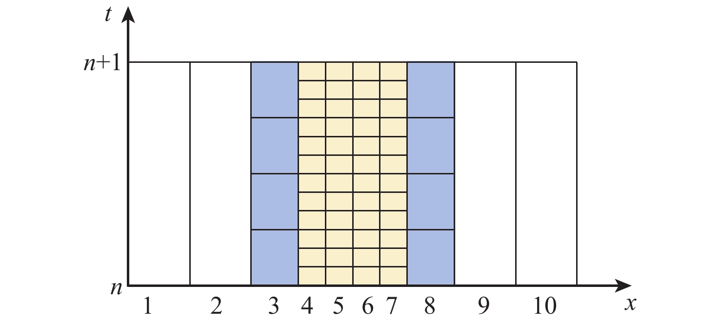
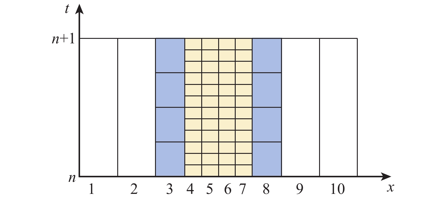
图 2 相对时间基准层时间粒度剖分示意
Figure 2. Schematic diagram of time granularity subdivision relative to time reference layer
表 1 空间网格码部分层级与北斗网格码兼容性
Table 1. Spatial grid code part levels and Beidou grid codes compatibility
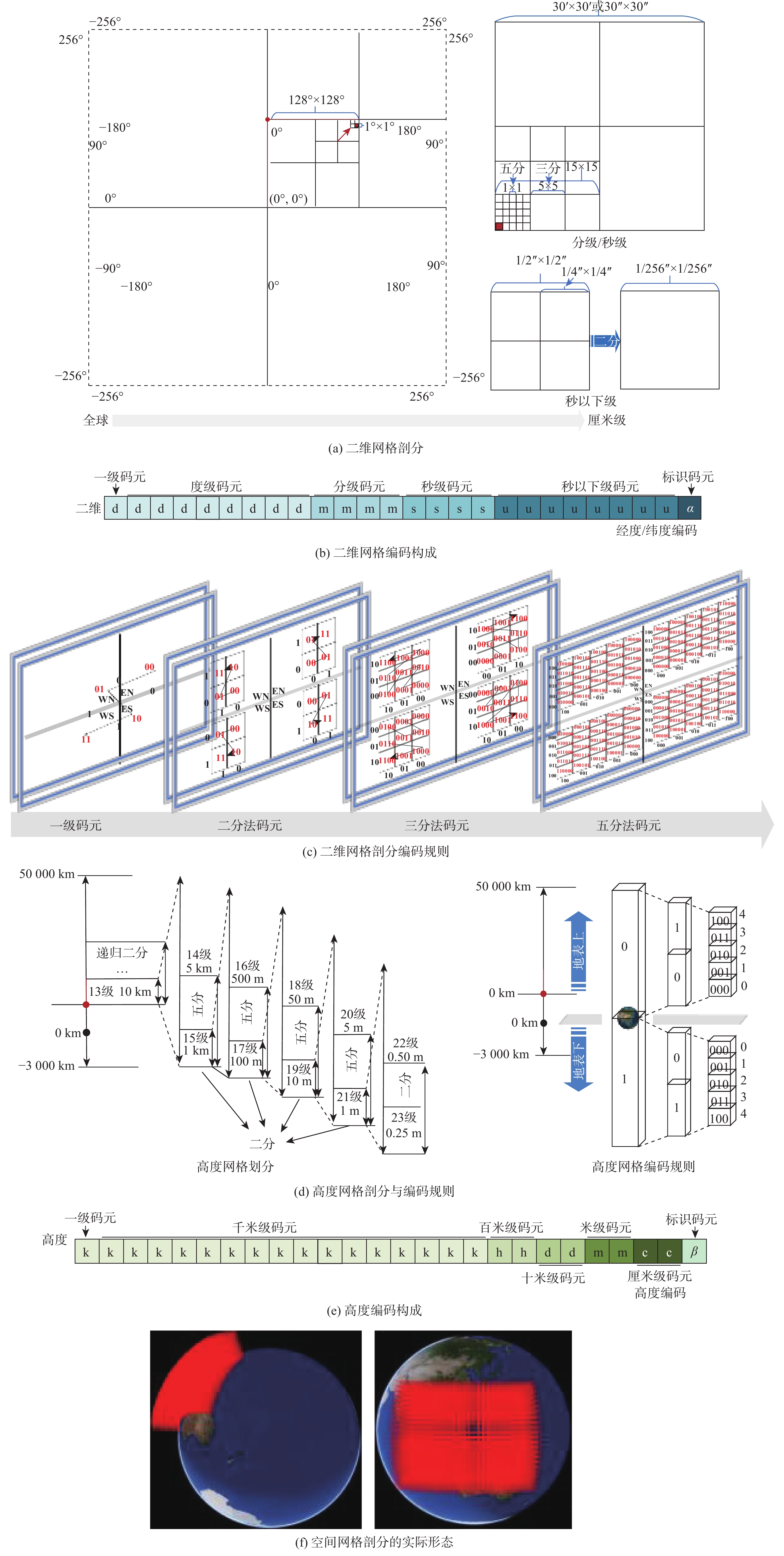
北斗网格位置码 空间网格码 转换方式 层级 网格大小 层级 网格大小 1 6°×4° 8 2°×2° 网格聚合3×2个 1 6°×4° 9 1°×1° 网格聚合6×4个 2 30′×30′ 10 30′×30′ 网格等价 2 30′×30′ 11 15′×15′ 网格聚合2×2个 2 30′×30′ 12 5′×5′ 网格聚合6×6个 2 30′×30′ 13 1′×1′ 网格聚合30×30个 3 15′×10′ 13 1′×1′ 网格聚合15×10个 4 1′×1′ 13 1′×1′ 网格等价 4 1′×1′ 14 30″×30″ 网格聚合2×2个 4 1′×1′ 15 15″×15″ 网格聚合4×4个 4 1′×1′ 16 5″×5″ 网格聚合12×12个 5 4″×4″ 17 1″×1″ 网格聚合4×4个 6 2″×2″ 17 1″×1″ 网格聚合2×2个 6 2″×2″ 18 1/2″×1/2″ 网格聚合4×4个 7 1/4″×1/4″ 19 1/4″×1/4″ 网格等价 7 1/4″×1/4″ 20 1/8″×1/8″ 网格聚合2×2个 7 1/4″×1/4″ 21 1/16″×1/16″ 网格聚合4×4个 8 1/32″×1/32″ 22 1/32″×1/32″ 网格等价 8 1/32″×1/32″ 23 1/64″×1/64″ 网格聚合2×2个 8 1/32″×1/32″ 24 1/128″×1/128″ 网格聚合4×4个 9 1/256″×1/256″ 25 1/256″×1/256″ 网格等价  下载: 导出CSV
表 2 改进型时间剖分层级
Table 2. Improved time subdivision levels
时间层级 时间尺度 任务类型 机型代表 1 (60 min)1 h 战略级 MQ-9无人机 2 15 min 战役级 3 5 min 过渡级1 4 (60 s)1 min 战术级 RQ-28A无人机 5 15 s 过渡级2 6 5 s 定位级 旋翼无人机 7 1 s 精确级 微型无人机
下载: 导出CSV
表 3 多源要素参数
Table 3. Multi-source factor parameter
参数名称 位置 范围/km 坐标 A1雷达中心 (经度7.721°,纬度22.002°) Rmax=140 (32,24) A2雷达中心 (经度118.331°,纬度22.832°) Rmax=120 (39,33) B火炮中心 (经度116.010°,纬度23.764°) RAmax=80
RAmin=50(12,45) C干扰中心 (经度116.066°,纬度21.766°) RImax=100
RImin=60(12,21) D1空域范围 (经度118.833°,纬度24.083°) (45,48) (经度119.173°,纬度24.417°), (50,53) (经度118.326°,纬度24.750°), (39,57) (经度118.653°,纬度23.665°) (43,43) D2空域范围 (经度115.417°,纬度20.426°) (5,5) (经度115.250°,纬度20.734°), (3,8) (经度115.750°,纬度21.083°), (9,12) (经度116.103°,纬度20.065°) (13,0) D2空域范围 (经度118.833°,纬度24.083°) (45,48) (经度119.1733°,纬度24.417°), (50,53) (经度118.326°,纬度24.750°), (39,57) (经度118.653°,纬度23.665°) (43,43) D3空域范围 (经度119.417°,纬度20.250°) (53,3) (经度118.750°,纬度20.667°), (45,3) (经度119.583°,纬度21.022°), (54,12) (经度119.461°,纬度20.583°) (53,6) E建筑区域 (经度118.000° ~118.016°,
纬度23.500° ~23.516°)
下载: 导出CSV
表 4 网格剖分层级信息
Table 4. Grid subdivision hierarchical information
二维 高程 范围 层级 尺度/km 层级 尺度/km 经度范围/(°) 纬度范围/(°) 11 27.8 13 10 115.000~120.000 20.000 ~25.000 11 27.8 14 5 115.000~120.000 20.000 ~25.000 12 9.2 15 1 115.000 ~120.000 20.000 ~25.000 13 1.8 15 1 115.000 ~120.000 20.000 ~25.000 14 0.9 15 1 115.000 ~120.000 20.000 ~25.000 19 0.0077 21 0.001 118.000 ~118.016 23.500 ~23.516
下载: 导出CSV
表 5 2个雷达探测范围重叠范围计算结果
Table 5. Two radar detection range overlap ranges calculation results
层级 雷达探测范围体元数 相交体
元数∆N相交体元
用时t/sV1/ km3 V2/ km3 V3/ km3 相对
误差$ {\varepsilon }_{1} $/%相对
误差$ {\varepsilon }_{2} $/%平均相对
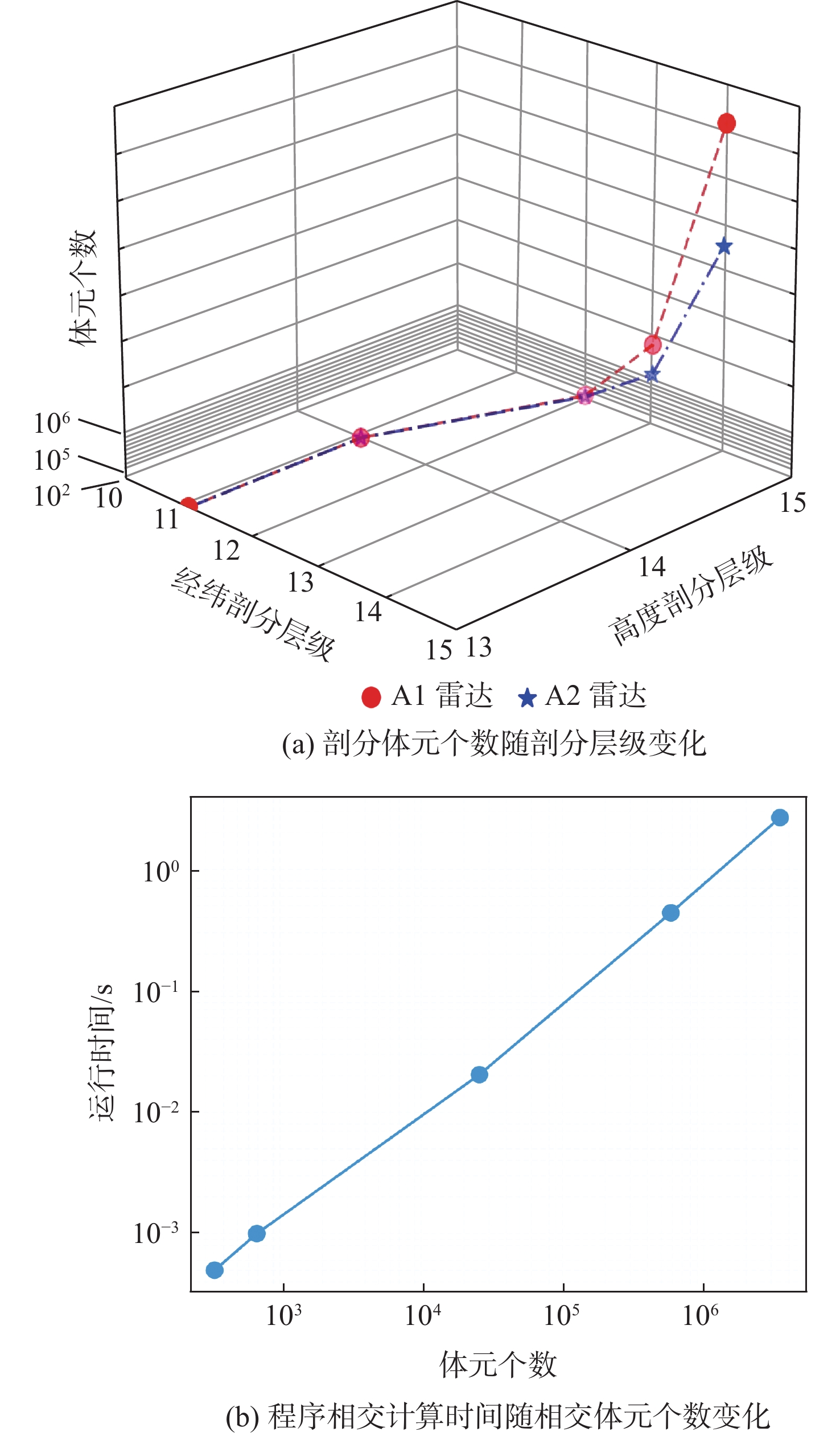
误差$ \overline{\varepsilon } $/%Lλφ Lh A1雷达N1 A2雷达N2 11 13 982 672 345 0.000 5 1.278 2×10⁷ 9.361×10⁶ 9.354×10⁶ 36.545 36.647 36.596 11 14 1 944 1 344 686 0.001 0 1.270 5×10⁷ 9.361×10⁶ 9.354×10⁶ 35.723 35.824 35.774 12 15 73 756 46 576 25 777 0.020 4 1.018 4×10⁷ 9.361×10⁶ 9.354×10⁶ 8.792 8.873 8.833 13 15 1 808 612 1 142 764 583 746 0.438 9 9.562 0×106 9.361×10⁶ 9.354×10⁶ 2.147 2.223 2.185 14 15 7 186 240 4 535 048 3 457 284 2.672 6 9.494 0×106 9.361×10⁶ 9.354×10⁶ 1.330 1.497 1.414
下载: 导出CSV
-
[1] 赵彦杰, 袁莞迈, 梁月乾. 智能无人集群: 改变未来战争的颠覆性力量[M]. 北京: 电子工业出版社, 2024: 37-40.Zhao Y J, Yuan (G/W)M, Liang Y Q. Intelligent unmanned swarm[M]. Beijing: Publishing House of Electronics Industry, 2024: 37-40(in Chinese). [2] Hu X T, Pang B Z, Dai F Q, et al. Risk assessment model for UAV cost-effective path planning in urban environments[J]. IEEE Access, 2020, 8: 150162-150173. [3] Miao S X, Cheng C Q, Zhai W X, et al. A low-altitude flight conflict detection algorithm based on a multilevel grid spatiotemporal index[J]. ISPRS International Journal of Geo-Information, 2019, 8(6): 289. [4] Hage G, Santoso A, Sahal M. Integrated radar and missile system with Poisson-prioritized threat management and PPN guidance for countering multiple UAV threats[J]. Journal of Robotics and Control, 2024, 6(1): 294-305. [5] 郭星华, 朱伟, 郭锦杰. 时空剖分网格在指挥控制系统中的应用展望[J]. 指挥信息系统与技术, 2022, 13(4): 80-84.Guo X H, Zhu W, Guo J J. Application prospect of spatiotemporal subdividing grid in command and control system[J]. Command Information System and Technology, 2022, 13(4): 80-84(in Chinese). [6] Dong C, Zhang Y F, Jia Z Y, et al. Three-dimension collision-free trajectory planning of UAVs based on ADS-B information in low-altitude urban airspace[J]. Chinese Journal of Aeronautics, 2025, 38(2): 103170. [7] 徐鑫宇, 万路军, 陈平, 等. 基于GeoSOT网格的空域栅格化表征方法[J]. 空军工程大学学报(自然科学版), 2021, 22(2): 15-22.Xu X Y, Wan L J, Chen P, et al. An airspace raster representation method based on GeoSOT grid[J]. Journal of Air Force Engineering University (Natural Science Edition), 2021, 22(2): 15-22(in Chinese). [8] 国家市场监督管理总局, 国家标准化管理委员会. 地球空间网格编码规则: GB/T 40087—2021[S]. 北京: 中国标准出版社, 2021.State Administration for Market Regulation, Standardization Administration of the People’s Republic of China. Geospatial grid encoding rule: GB/T 40087—2021[S]. Beijing: Standards Press of China, 2021(in Chinese). [9] 国家市场监督管理总局, 国家标准化管理委员会. 北斗网格位置码: GB/T 39409—2020[S]. 北京: 中国标准出版社, 2020.State Administration for Market Regulation, Standardization Administration of the People’s Republic of China. BeiDou grid location code: GB/T 39409—2020[S]. Beijing: Standards Press of China, 2020(in Chinese). [10] 国家市场监督管理总局, 国家标准化管理委员会. 北斗剖分时间码: GB/T 42578—2023[S]. 北京: 中国标准出版社, 2023.State Administration for Market Regulation, Standardization Administration of the People’s Republic of China. BeiDou subdivision time code: GB/T 42578—2023[S]. Beijing: Standards Press of China, 2023(in Chinese). [11] 山海涛, 程承旗, 陈波. 网格环境下战场环境信息集成服务策略[J]. 测绘科学, 2020, 45(1): 189-193.Shan H T, Cheng C Q, Chen B. Integrated service strategy of battlefield environment information ingrid environment[J]. Science of Surveying and Mapping, 2020, 45(1): 189-193(in Chinese). [12] Deng C, Cheng C Q, Qu T T, et al. A method for managing ADS-B data based on a 4D airspace-temporal grid (GeoSOT-AS)[J]. Aerospace, 2023, 10(3): 217. [13] 季荣涛. 基于威胁分析的战场空间划分及其在航迹规划中的应用[D]. 南京: 南京大学, 2016: 27-34.Ji R T. The partition of battlefield base on threat analysis and its application in route planning[D]. Nanjing: Nanjing University, 2016: 27-34(in Chinese). [14] 吴乾坤. 基于全空间剖分的战场空间构建和高性能空间计算研究[D]. 北京: 中国电子科技集团公司电子科学研究院, 2022: 17-26.Wu Q K. Researched on battlefield construction and high-performance space computing based on full space subdivision[D]. Beijing: China Academy of Electronic and Information Technology, 2022: 17-26(in Chinese). [15] 李锋, 万刚, 蒋秉川, 等. 地空一体化战场时空数据组织模型及应用[J]. 系统仿真学报, 2017, 29(11): 2637-2643.Li F, Wan G, Jiang B C, et al. Spatio-temporal data organization model of unified ground and aerial battlefield and its application[J]. Journal of System Simulation, 2017, 29(11): 2637-2643(in Chinese). [16] 袁越, 程承旗, 童晓冲. 基于剖分表达结构的雷达探测范围计算方法[J]. 地理信息世界, 2017, 24(6): 29-36.Yuan Y, Cheng C Q, Tong X C. Calculation method of radar detection range based on subdivision expression structure[J]. Geomatics World, 2017, 24(6): 29-36(in Chinese). [17] 周畅. 面向动态威胁的无人机多目标三维航迹规划[D]. 大连: 大连理工大学, 2021: 12-15.Zhou C. Multi-objective 3D path planning for UAV under mobile threats[D]. Dalian: Dalian University of Technology, 2021: 12-15(in Chinese). [18] Han B, Qu T T, Tong X C, et al. Grid-optimized UAV indoor path planning algorithms in a complex environment[J]. International Journal of Applied Earth Observation and Geoinformation, 2022, 111: 102857. [19] 孙忠秋, 程承旗. GeoSOT-3D椭球体剖分真三维数据表达[J]. 地理信息世界, 2016, 23(3): 40-46.Sun Z Q, Cheng C Q. True 3D data expression based on GeoSOT-3D ellipsoid subdivision[J]. Geomatics World, 2016, 23(3): 40-46(in Chinese). [20] 张晨, 赵青松, 陆志沣, 等. 战场态势要素构成及影响关系研究[J]. 舰船电子工程, 2023, 43(3): 33-35.Zhang C, Zhao Q S, Lu Z F, et al. Research on composition and influence of battlefield situation elements[J]. Ship Electronic Engineering, 2023, 43(3): 33-35(in Chinese). [21] 王孟阳, 张栋, 唐硕, 等. 复杂动态环境下多无人机目标跟踪的分布式协同轨迹规划方法[J]. 指挥与控制学报, 2024, 10(2): 197-212.Wang M Y, Zhang D, Tang S, et al. A distributed collaborative trajectory planning method for multi-UAV targets tracking in complex dynamic environment[J]. Journal of Command and Control, 2024, 10(2): 197-212(in Chinese). [22] Hu H, Liu M, Zhong J Q, et al. A case study of the 3D water vapor tomography model based on a fast voxel traversal algorithm for ray tracing[J]. Remote Sensing, 2021, 13(12): 2422. [23] 屠壮, 杨柳庆, 林志坚, 等. 城市作战背景下多无人机航路规划仿真研究[J]. 舰船电子工程, 2024, 44(9): 48-54.Tu Z, Yang L Q, Lin Z J, et al. Simulation research on multi-UAV route planning under the background of urban combat[J]. Ship Electronic Engineering, 2024, 44(9): 48-54(in Chinese). [24] 许东来, 戴树荪, 彭学愚. 双(多)基地雷达的探测范围和定位精度的分析[J]. 西安电子科技大学学报, 1993, 20(2): 87-99.Xu D L, Dai S S, Peng X Y. The analysis of detection coverage and locating precision of the bistalic and multistatic radar[J]. Journal of Xidian University, 1993, 20(2): 87-99(in Chinese). -

 下载:
下载:


 点击查看大图
计量
- 文章访问数: 221
- HTML全文浏览量: 97
- PDF下载量: 9
- 被引次数: 0
