





Multi-UAV path planning for forest fire-fighting in plateau based on adaptive improved dung beetle optimization algorithm
-
摘要:
针对高原森林复杂环境下无人机灭火救援路径规划问题,提出基于自适应改进蜣螂(AIDBO)算法的多无人机路径规划方法。基于数字高程模型(DEM)数据建立高原森林山区三维地理空间模型,考虑复杂地形、环境风、海拔等因素的影响,以最小飞行时间、风险代价、能耗代价为目标函数,建立从救援临时基地起飞,抵达可能存在灾害区域的多约束条件下多无人机路径规划模型;通过混沌映射与反向学习优化种群初始化,引入鲸鱼优化算法(WOA)的螺旋搜索策略丰富位置更新机制,采用自适应柯西变异增强种群摆脱局部最优的能力,提出一种AIDBO算法进行求解。结果表明:AIDBO 算法平均适应度较传统蜣螂(DBO)算法、改进蜣螂(IDBO)算法分别提升10.59%、9.82%;与平原海拔340 m 环境相比,海拔
2400 m环境下无人机最长飞行时间略微增加了0.997%,而最大飞行能耗代价增加了58.96%;同时,风向和风速也会对飞行时间和能耗有一定影响。所提AIDBO算法能显著优化高原森林多无人机路径,为高原森林无人机灭火救援调度提供决策支持。Abstract:Aiming at the problem of UAV fire-fighting and rescue path planning in the complex environment of plateau forest, a multi-UAV path planning method based on an adaptive improved dung beetle optimization (AIDBO) algorithm was proposed. Based on the digital elevation model (DEM) data, a three-dimensional geospatial model of the plateau forest and mountainous area was established. Considering the influence of complex terrain, environmental wind, altitude and other factors, a multi-UAV path planning model under multiple constraints was established, taking the minimum flight time, risk cost and energy consumption as the objective function. Chaotic mapping and reverse learning optimize the population initialization, the whale optimization algorithm (WOA) introduces the spiral search strategy to enhance the position update mechanism, and adaptive Cauchy mutation improves the population’s capacity to eliminate local optima. An AIDBO algorithm is proposed to solve the problem. The results showed that the average fitness of AIDBO was 10.59% and 9.82% higher than that of the original dung beetle optimization (DBO) algorithm and the improved dung beetle optimization (IDBO) algorithm, respectively. Compared with a 340 m plain environment, the maximum flight time of the UAV in a
2400 m altitude environment is slightly increased by 0.997%, while the energy consumption is increased by 58.96%. At the same time, the wind direction and speed will also have a certain impact on the flight time and energy consumption. In addition to providing decision assistance for UAV firefighting and rescue scheduling in the plateau forests, the adaptive improved dung beetle algorithm presented in this research may greatly optimize the multi-UAV path in the plateau forests. -
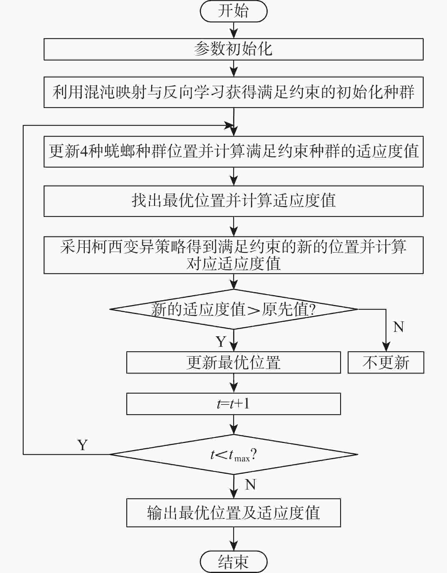
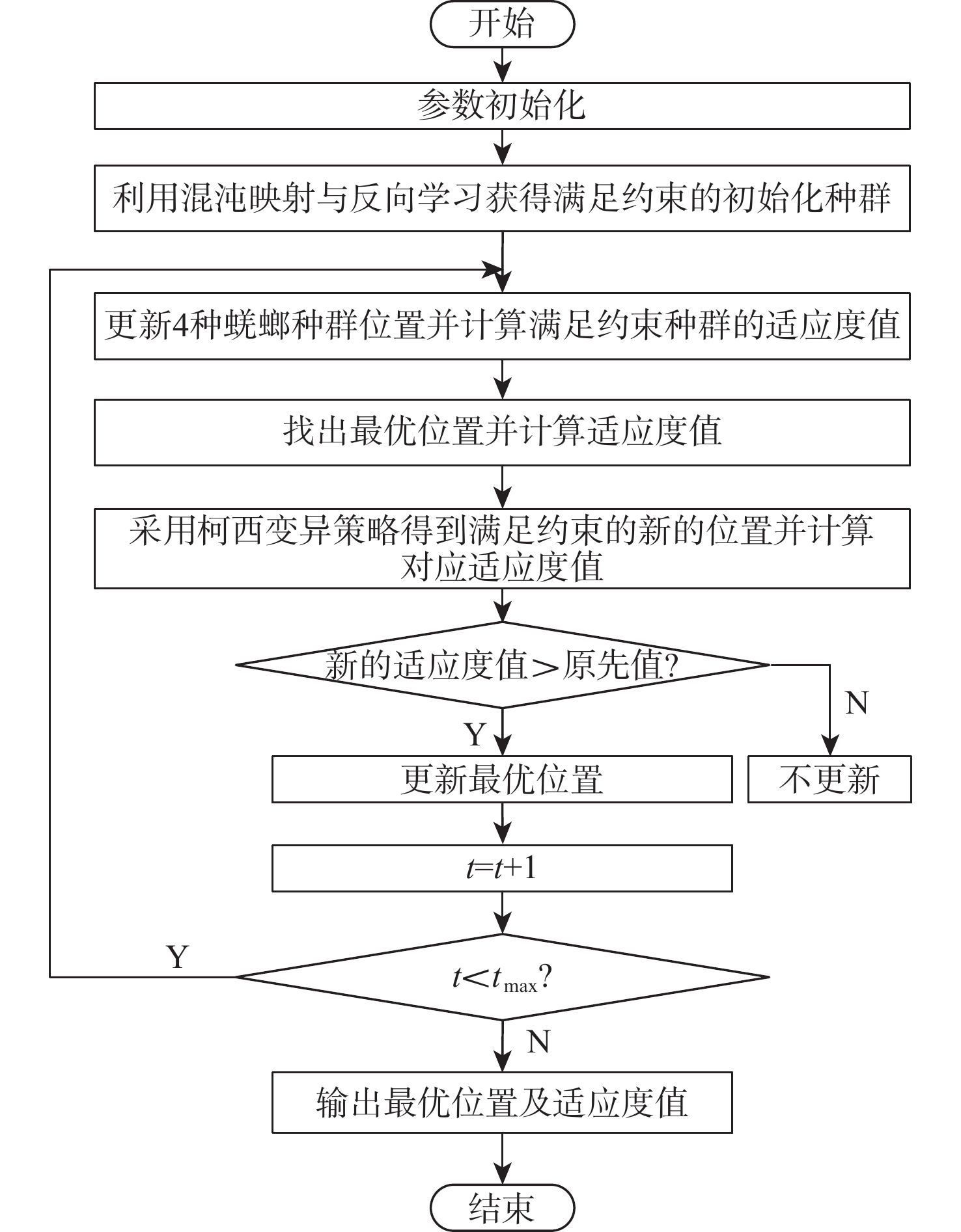
图 2 自适应改进蜣螂优化算法流程
Figure 2. Flowchart of adaptive improved dung beetle optimization algorithm
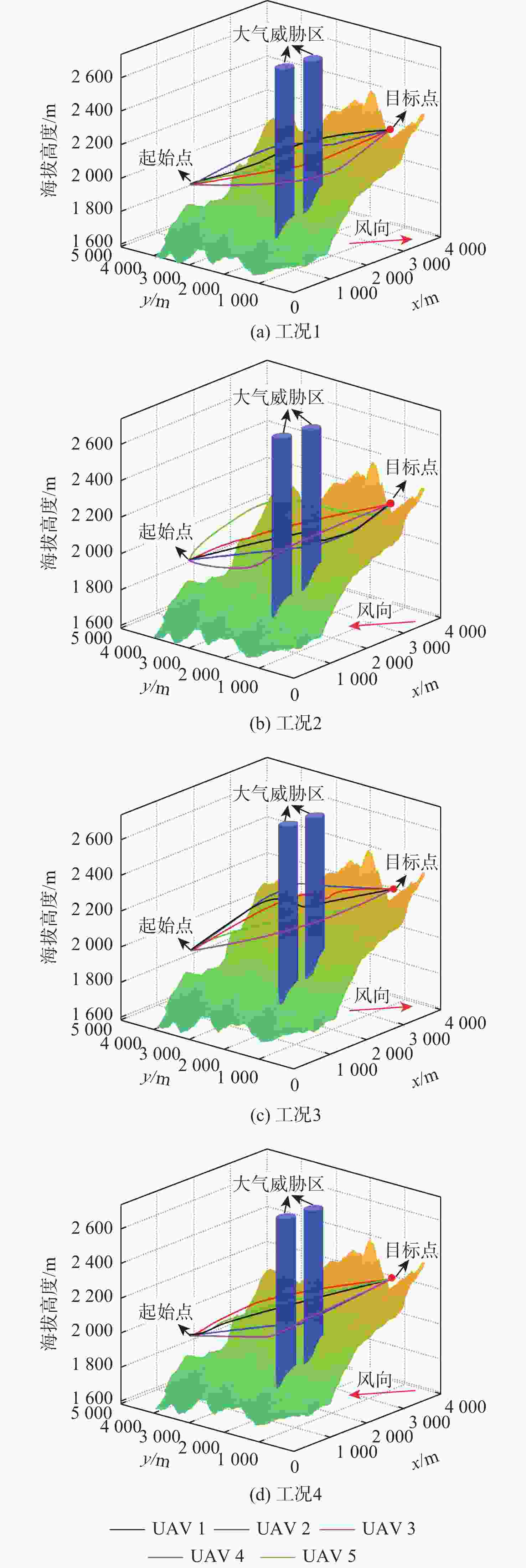
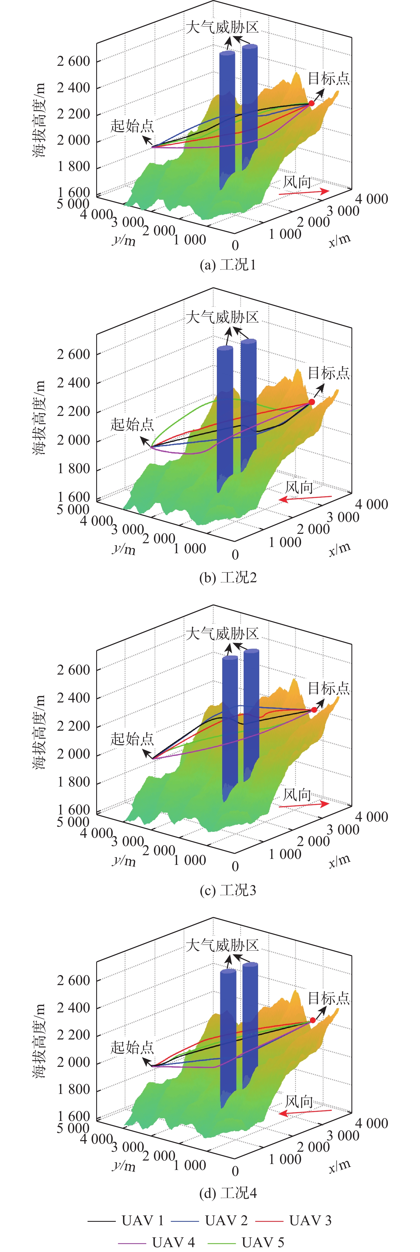
图 8 不同风速风向工况下路径规划结果
Figure 8. Results of path planning by different wind speed and direction conditions
表 1 测试函数表达式
Table 1. Test Function Expression
函数 表达式 维度 搜索范围 $ {F}_{1} $ $ {F}_{1}(x)=\displaystyle\sum \limits_{i=1}^{n}x_{i}^{2} $ 30 [−100,100] $ {F}_{2} $ $ {F}_{2}(x)=\displaystyle\sum \limits_{i=1}^{n}\left| {x}_{i}\right| +\prod \limits_{i=1}^{n}\left| {x}_{i}\right| $ 30 [−10,10] $ {F}_{3} $ $ {F}_{3}(x)=\displaystyle\sum \limits_{i=1}^{n}{\left(\displaystyle\sum \limits_{j=1}^{i}x_{j}^{2}\right)}^{2} $ 30 [−100,100] $ {F}_{4} $ $ {F}_{4}(x)=\displaystyle\sum \limits_{i=1}^{n}ix_{i}^{4}+{\mathrm{random}}[0,1) $ 30 [−1.28,1.28] $ {F}_{5} $ $ {F}_{5}(x)=\displaystyle\sum \limits_{i=1}^{n}[x_{i}^{2}-10\cos (2{\text{π}} {x}_{i})+10] $ 30 [−5.12,5.12] $ {F}_{6} $ $ \begin{aligned}& F_6(x)=-20 \exp \left(-0.2 \sqrt{\frac{1}{n} \displaystyle\sum_{i=1}^n x_i^2}\right) - \\&\qquad \exp \left(\frac{1}{n} \displaystyle\sum_{i=1}^n \cos( 2 \text{π} x_i)\right)\end{aligned} $ 30 [−32,32]  下载: 导出CSV
参数 数值 转子半径$ R_{\mathrm{r}} $/m 0.5 转子盘面积$ A $/m2 0.785 剖面阻力系数$ \delta $ 0.008 叶片角速度$ \varOmega $/($ {\mathrm{rad}}\cdot {{\mathrm{s}}}^{-1} $) 180 机身阻力比$ {d}_{0} $ 0.6 转子固体度$ s $ 0.05 感应功率增量修正系数$ \kappa $ 0.1 无人机总质量$ {W}_{q} $/kg 60 无人机空速$ {v}_{{\mathrm{a}}} $/($ {\mathrm{m}}\cdot {{\mathrm{s}}}^{-1} $) 15 最大飞行高度$ {H}_{\max } $/m 300 安全距离$ {h}_{{\mathrm{safe}}} $/m 80 无人机之间的安全距离$ {d}_{pq,\min } $/m 10
下载: 导出CSV
表 3 环境参数设置
Table 3. Environment parameter configuration
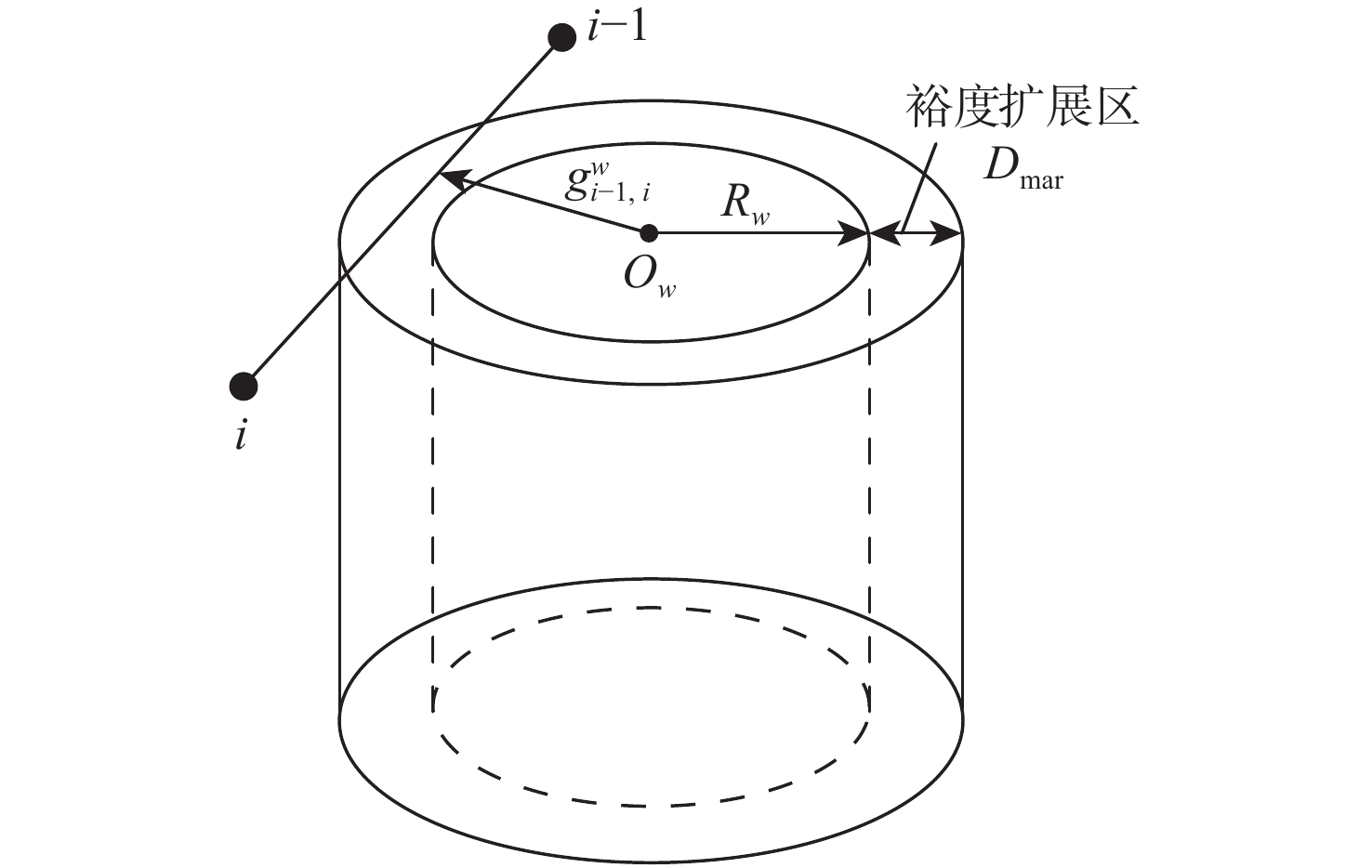
参数 设置 无人机1起始点坐标/m (600, 3620 ,2000 )无人机2起始点坐标/m (600, 3600 ,2000 )无人机3起始点坐标/m (600, 3580 ,2000 )无人机4起始点坐标/m (580, 3600 ,2000 )无人机5起始点坐标/m (620, 3600 ,2000 )目标点坐标/m ( 3000 ,300,2300 )大气威胁区1坐标1/m ( 1300 ,1600 )大气威胁区1半径2/m 200 大气威胁区2坐标1/m ( 2000 ,1500 )大气威胁区2半径2/m 200 风速/($ {\mathrm{m}}\cdot {{\mathrm{s}}}^{-1} $) 8 风向 西北(以y轴正向为北,x轴正向为东) 温度/℃ 15 大气威胁区裕度扩展宽度$ {D}_{{\mathrm{mar}}} $/m 50
下载: 导出CSV
表 4 混沌映射参数$ \gamma $对算法性能的影响
Table 4. Influence of chaotic mapping parameter $ \gamma $ on algorithm performance
$ \gamma $ 最优适应度值 平均适应度值 标准差 0.3 3.305 3.425 0.235 0.5 2.984 3.224 0.251 0.7 3.412 3.589 0.312
下载: 导出CSV
表 5 螺旋搜索参数$ c $对算法性能的影响
Table 5. Influence of spiral search parameters $ c $ on algorithm performance
$ c $ 最优适应度值 平均适应度值 标准差 0.5 3.284 3.476 0.267 1.0 2.984 3.224 0.251 2.0 3.396 3.512 0.301
下载: 导出CSV
表 6 算法性能对比
Table 6. Algorithm performance comparison
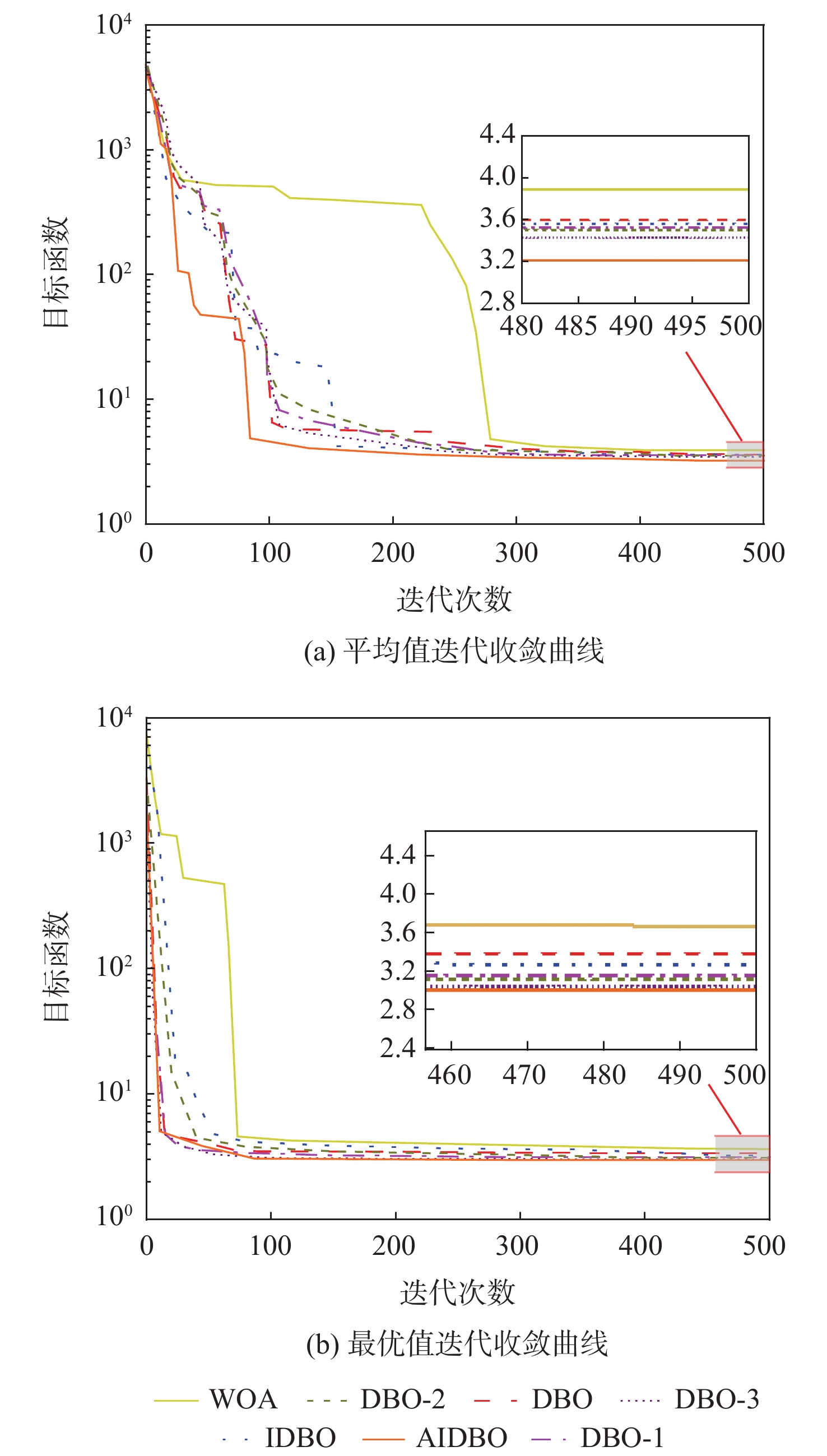
算法 最优适应度值 平均适应度值 标准差 平均运行时间/s WOA 3.746 4.259 0.415 28.7 DBO 3.372 3.606 0.330 25.2 IDBO 3.252 3.575 0.285 26.9 DBO-1 3.275 3.523 0.367 25.8 DBO-2 3.198 3.512 0.325 26.5 DBO-3 3.102 3.401 0.298 26.3 AIDBO 2.984 3.224 0.251 26.5
下载: 导出CSV
表 7 不同算法路径规划结果对比
Table 7. Comparison of path planning results of different algorithms
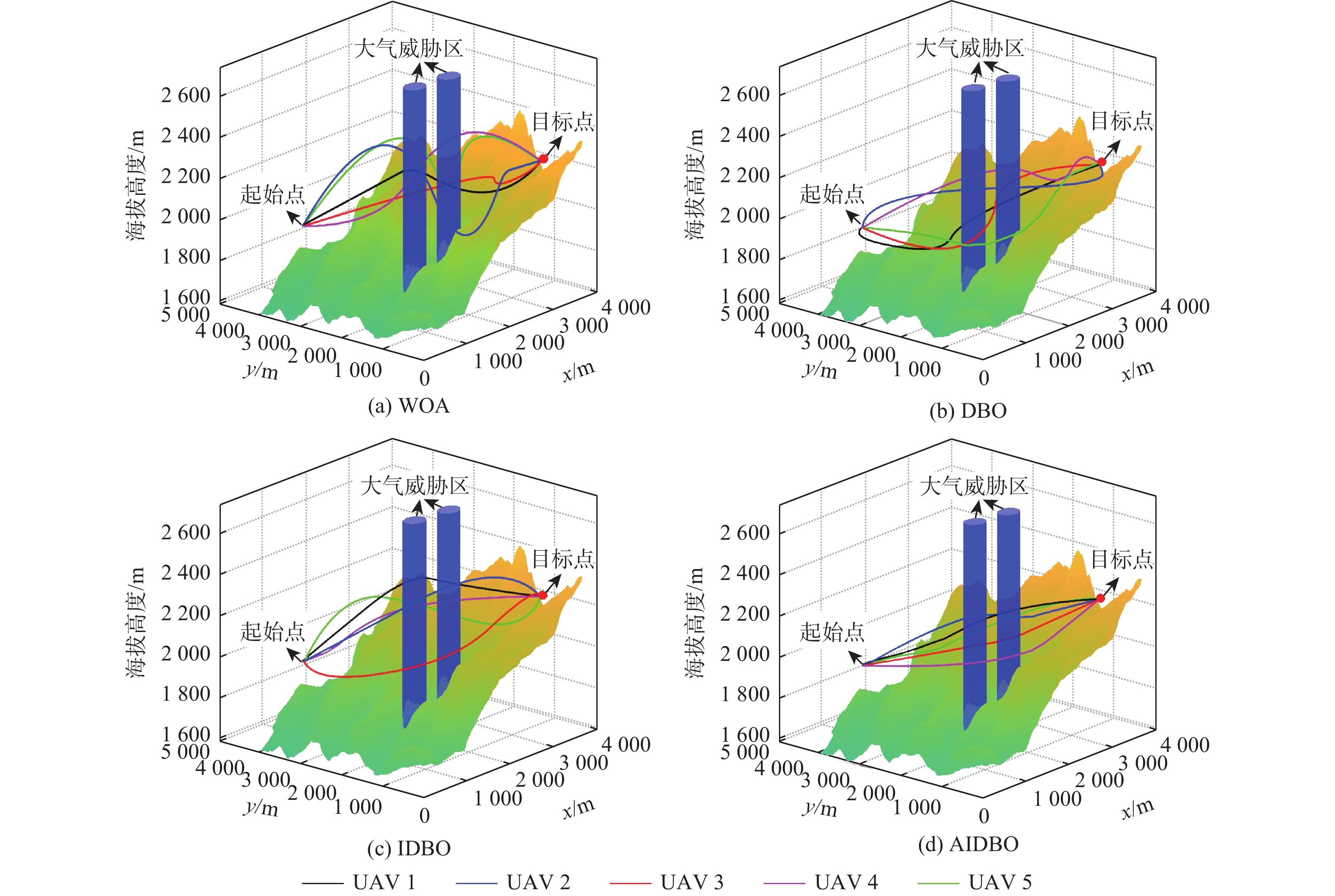
算法 UAV 飞行时间/s 风险代价 能耗代价/104 kJ WOA UAV1 309.996 0.810 2.29 UAV2 442.991 0.130 2.67 UAV3 333.989 0.120 2.54 UAV4 369.994 0.130 2.31 UAV5 366.980 0.120 2.32 DBO UAV1 346.398 0.125 2.40 UAV2 320.627 0.116 2.39 UAV3 306.521 0.108 2.42 UAV4 314.929 0.113 2.51 UAV5 334.831 0.122 2.39 IDBO UAV1 306.998 0.102 2.13 UAV2 305.944 0.103 2.19 UAV3 312.998 0.099 2.23 UAV4 333.909 0.107 2.22 UAV5 317.997 0.108 2.11 AIDBO UAV1 280.997 0.094 2.08 UAV2 276.812 0.096 2.10 UAV3 273.999 0.095 2.04 UAV4 302.994 0.103 2.13 UAV5 296.976 0.098 2.09
下载: 导出CSV
表 8 不同海拔路径规划结果对比
Table 8. Comparison of path planning results at different altitudes
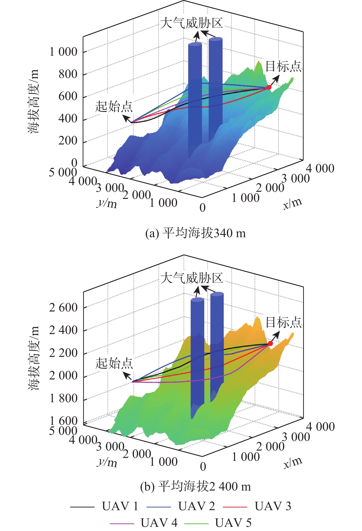
平均海拔/m UAV 飞行时间/s 风险代价 能耗代价/104 kJ 340 UAV1 281.984 0.097 1.31 UAV2 301.982 0.103 1.29 UAV3 283.999 0.096 1.29 UAV4 279.998 0.095 1.34 UAV5 299.997 0.098 1.29 2400 UAV1 280.997 0.094 2.08 UAV2 276.812 0.096 2.10 UAV3 273.999 0.095 2.04 UAV4 304.993 0.103 2.13 UAV5 296.976 0.098 2.09
下载: 导出CSV
表 9 风速风向影响参数设置
Table 9. Parameter settings for investigating impact of wind speed and direction
工况 平均海拔/m 风速/(m·s−1) 风向 1 2 400 8 西北风(顺风) 2 2 400 8 东南风(逆风) 3 2 400 10 西北风(顺风) 4 2 400 10 东南风(逆风)
下载: 导出CSV
表 10 不同风速风向路径规划结果对比
Table 10. Comparison of path planning results at different wind speed and direction paths
工况 UAV 飞行
时间/s风险
代价能耗代价/
104 kJ总能耗代价/
105 kJ1 UAV1 280.997 0.094 2.08 1.044 UAV2 276.812 0.096 2.10 UAV3 273.999 0.095 2.04 UAV4 302.994 0.103 2.13 UAV5 296.976 0.098 2.09 2 UAV1 284.953 0.094 2.25 1.122 UAV2 286.330 0.099 2.25 UAV3 278.997 0.097 2.20 UAV4 304.996 0.103 2.29 UAV5 291.997 0.096 2.23 3 UAV1 294.979 0.104 2.38 1.181 UAV2 279.958 0.103 2.21 UAV3 281.996 0.237 2.49 UAV4 305.943 0.446 2.31 UAV5 285.998 0.756 2.42 4 UAV1 289.959 0.334 2.52 1.265 UAV2 304.989 0.719 2.46 UAV3 284.990 0.099 2.48 UAV4 322.988 0.839 2.75 UAV5 287.916 0.910 2.44
下载: 导出CSV
-
[1] 潘卫军, 黄园晶, 骆晨, 等. 森林火灾多机型救援三维航迹规划[J]. 科学技术与工程, 2023, 23(23): 10152-10159.Pan W J, Huang Y J, Luo C, et al. 3D route planning for forest fire rescue by multi-aircraft[J]. Science Technology and Engineering, 2023, 23(23): 10152-10159(in Chinese). [2] 郑玉斌, 李新凯, 孟月, 等. 基于GRU-MAPPO的多无人机协同追捕方法[J/OL]. 北京航空航天大学学报, 2025(2025-07-02)[2025-11-19]. https://link.cnki.net/urlid/11.2625.V.20250702.1040.001.Zheng Y B, Li X K, Meng Y, et al. Multi-UAV cooperative pursuit method based on GRU-MAPPO[J/OL]. Journal of Beijing University of Aeronautics and Astronautics, 2025(2025-07-02) [2025-11-19]. https://link.cnki.net/urlid/11.2625.V.20250702.1040.001(in Chinese). [3] 滕菲, 王迎春, 姚永辉, 等. 基于深度强化学习的无人机动态避障规划[J/OL]. 北京航空航天大学学报, 2025(2025-05-23)[2025-11-19]. https://link.cnki.net/urlid/11.2625.V.20250523.1437.002.Teng F, Wang Y C, Yao Y H, et al. UAV dynamic obstacle avoidance planning based on deep reinforcement learning[J/OL]. Journal of Beijing University of Aeronautics and Astronautics, 2025(2025-05-23) [2025-11-19]. https://link.cnki.net/urlid/11.2625.V.20250523.1437.002(in Chinses). [4] 朱元军, 李妍, 张学军, 等. 基于风险约束的城市空域无人机安全路径规划[J/OL]. 北京航空航天大学学报, 2025(2025-03-27) [2025-11-19]. https://link.cnki.net/urlid/11.2625.V.20250327.1510.001.Zhu Y J, Li Y, Zhang X J, et al. Risk-constrained safe path planning for unmanned aerial vehicles in urban airspace[J/OL]. Journal of Beijing University of Aeronautics and Astronautics, 2025(2025-03-27) [2025-11-19]. https://link.cnki.net/urlid/11.2625.V.20250327.1510.001(in Chinese). [5] 朱弥雪. 基于无人机的林火检测研究[D]. 呼和浩特: 内蒙古工业大学, 2023.Zhu M X. Research on UAV-based forest fire detection[D]. Hohhot: Inner Mongolia University of Tehchnology, 2023(in Chinese). [6] 余顺金, 冯建辉, 秦建明, 等. 基于改进人工势场的无人飞行器三维路径规划[J]. 云南电力技术, 2024, 52(3): 64-68.Yu S J, Feng J H, Qin J M, et al. Three-dimensional path planning of UAV based on improved artificial potential field[J]. Yunnan Electric Power, 2024, 52(3): 64-68(in Chinese). [7] 李锐君, 董素鸽. 基于粒子群算法的无人机灭火路径规划仿真[J]. 计算机仿真, 2023, 40(9): 43-48.Li R J, Dong S G. Simulation of UAV fire extinguishing path planning based on particle swarm optimization algorithm[J]. Computer Simulation, 2023, 40(9): 43-48(in Chinese). [8] Gao J F, Zheng Y, Ni K, et al. Fast path planning for firefighting UAV based on A-star algorithm[J]. Journal of Physics: Conference Series, 2021, 2029(1): 012103. [9] Demir K, Tumen V, Kosunalp S, et al. A deep reinforcement learning algorithm for trajectory planning of swarm UAV fulfilling wildfire reconnaissance[J]. Electronics, 2024, 13(13): 2568. [10] Radmanesh M, Sharma B, Kumar M, et al. PDE solution to UAV/UGV trajectory planning problem by spatio-temporal estimation during wildfires[J]. Chinese Journal of Aeronautics, 2021, 34(5): 601-616. [11] Aggarwal R, Soderlund A, Kumar M, et al. Risk-aware path planning for unmanned aerial systems in a spreading wildfire[J]. Journal of Guidance, Control, and Dynamics, 2022, 45(9): 1692-1708. [12] Çoğay S, Seçinti G. Phoenix: aerial monitoring for fighting wildfires[J]. Drones, 2023, 7(1): 19. [13] Hasan Z, Kumar S, Patel V, et al. UAV Path planning for wildfires-sustainably fighting wildfires with automated path planning for UAVs: NASA/TM—20220015156[R]. Washington, D. C. : NASA, 2022. [14] Xu Y Q, Li J M, Zhang F Q. A UAV-based forest fire patrol path planning strategy[J]. Forests, 2022, 13(11): 1952. [15] Xue J K, Shen B. Dung beetle optimizer: a new meta-heuristic algorithm for global optimization[J]. The Journal of Supercomputing, 2023, 79(7): 7305-7336. [16] Lyu L X, Jiang H, Yang F. Improved dung beetle optimizer algorithm with multi-strategy for global optimization and UAV 3D path planning[J]. IEEE Access, 2024, 12: 69240-69257. [17] Chen Q, Wang Y J, Sun Y F. An improved dung beetle optimizer for UAV 3D path planning[J]. The Journal of Supercomputing, 2024, 80(18): 26537-26567. [18] Zhu F, Li G S, Tang H, et al. Dung beetle optimization algorithm based on quantum computing and multi-strategy fusion for solving engineering problems[J]. Expert Systems with Applications, 2024, 236: 121219. [19] Shen Q W, Zhang D M, Xie M S, et al. Multi-strategy enhanced dung beetle optimizer and its application in three-dimensional UAV path planning[J]. Symmetry, 2023, 15(7): 1432. [20] 刘微, 任腾腾, 韩广雨, 等. 多策略改进蜣螂优化算法及其应用[J]. 电子测量技术, 2024, 47(12): 109-121.Liu W, Ren T T, Han G Y, et al. Multi strategy improvement of dung beetle optimization algorithm and its application[J]. Electronic Measurement Technology, 2024, 47(12): 109-121(in Chinese). [21] 李晓萌. 高原狭窄区域下多无人机协同飞行控制[D]. 南京: 南京航空航天大学, 2019.Li X M. Cooperative flight control of multi-UAVs in narrow plateau area[D]. Nanjing: Nanjing University of Aeronautics and Astronautics, 2019(in Chinese). [22] Zeng Y, Xu J, Zhang R. Energy minimization for wireless communication with rotary-wing UAV[J]. IEEE Transactions on Wireless Communications, 2019, 18(4): 2329-2345. -

 下载:
下载:

 点击查看大图
计量
- 文章访问数: 155
- HTML全文浏览量: 50
- PDF下载量: 16
- 被引次数: 0
