





Overview and prospect of key technologies for underwater gravity-aided inertial navigation
-
摘要:
水下高精度自主导航是海洋探索与开发的关键核心技术。惯性导航系统(INS)的定位误差随航行时间累积发散,需要外部信息辅助修正。地球重力场作为地球固有属性,兼具稳定性、自主性与无源性,是理想的信息源,由此发展而来的重力辅助惯性导航技术具有重要的研究价值。在分析系统基本原理与技术架构的基础上,围绕重力基准图构建、重力场适配性分析、重力匹配算法、航迹规划四大关键技术,系统梳理了多源数据融合、网格化插值、特征评估与适配区提取、序列相关匹配、非线性滤波、智能路径优化等主流方法的研究进展,深入剖析了当前技术发展中尚未解决的共性问题。针对现阶段研究存在的技术瓶颈展望未来研究发展方向,旨在为后续构建高精度、高可靠性和高自主性的水下重力辅助惯性导航系统(GAINS)提供理论参考与技术指引。
Abstract:Underwater high-precision autonomous navigation is a core enabling technology for ocean exploration and development. The positional error of an inertial navigation system (INS) builds up and diverges with time, requiring outside data to be corrected. As an inherent property of the Earth, the gravity field offers stability, autonomy, and passivity, making it an ideal information source. Consequently, gravity-aided inertial navigation technology holds significant research value. This paper systematically reviews the research progress of four important technologies: trajectory planning, gravity matching algorithms, gravity reference map construction, and gravity field adaptability analysis. It is based on an analysis of the system’s technical architecture and fundamental principles. Mainstream methods, such as multi-source data fusion, gridded interpolation, feature evaluation and matching area extraction, sequential correlation matching, nonlinear filtering, and intelligent path optimization, are comprehensively summarized. Furthermore, common unresolved issues in current technological development are thoroughly examined. Finally, in view of the technical bottlenecks at this stage, future research directions are discussed, aiming to provide theoretical references and technical guidance for the subsequent development of a high-precision, high-reliability, and high-autonomy underwater gravity-aided inertial navigation system (GAINS).
-
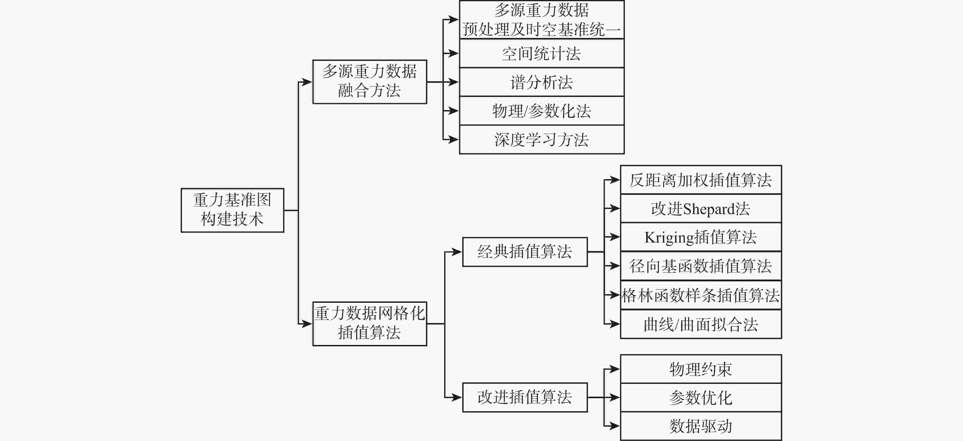
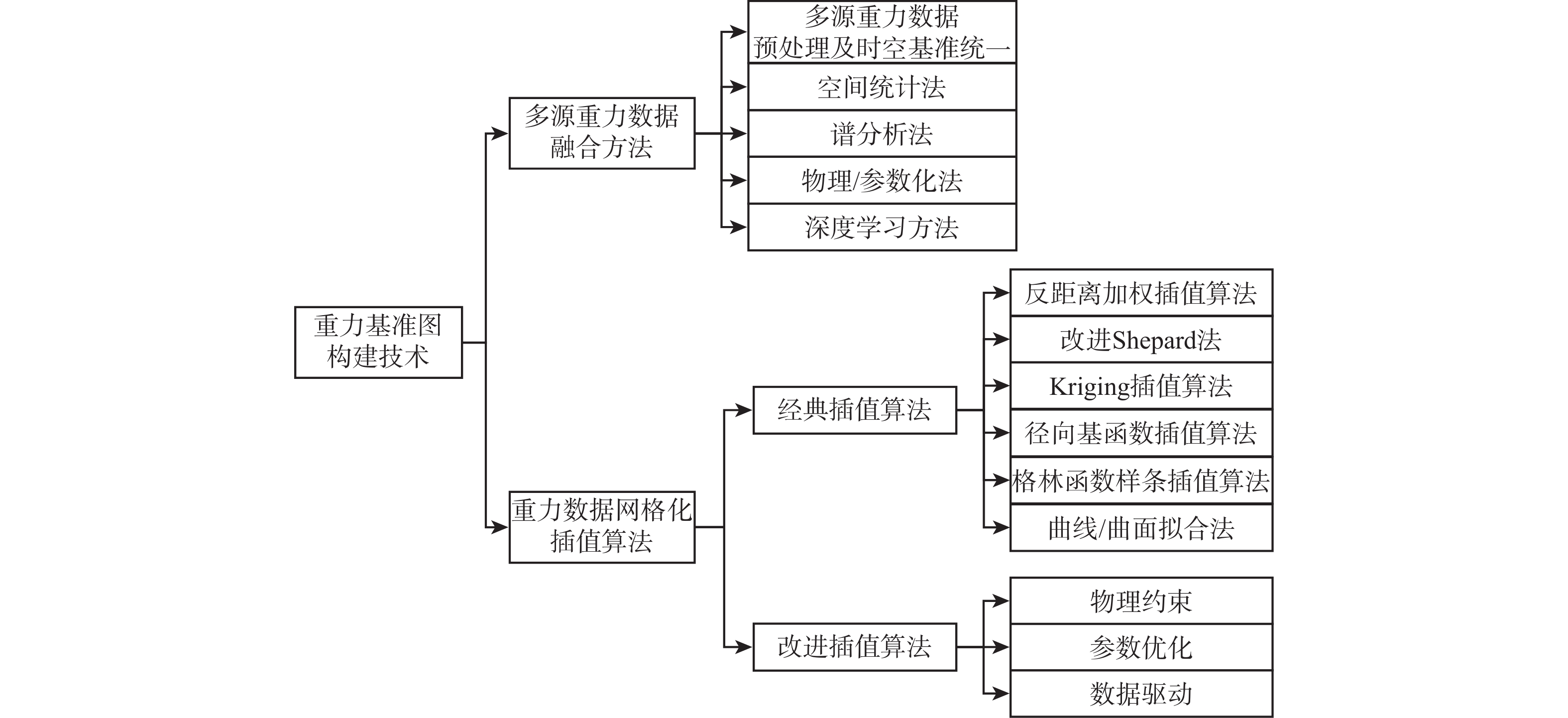
图 3 重力基准图构建核心技术及主要方法
Figure 3. Core technologies and main methods for constructing gravity reference maps
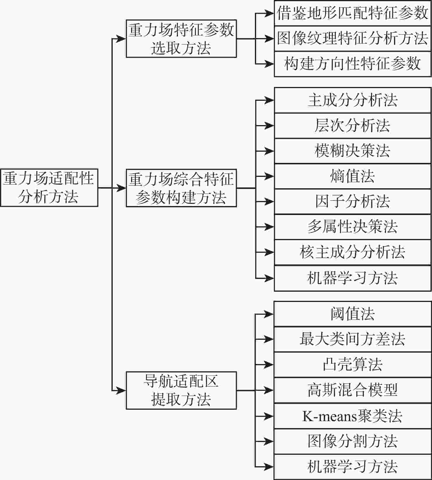
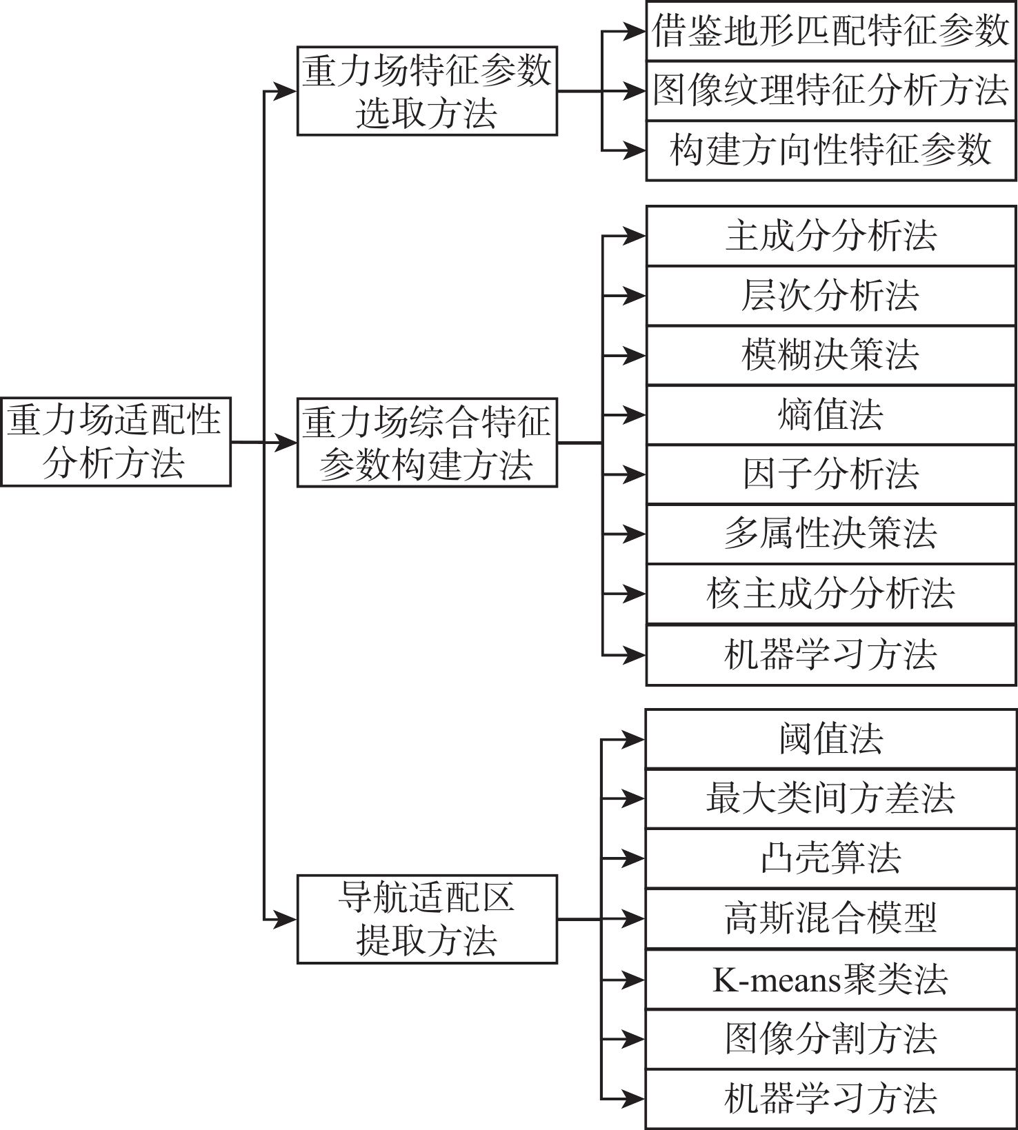
图 4 重力场适配性分析关键技术及主要方法
Figure 4. Key technologies and main methods for gravity field adaptability analysis
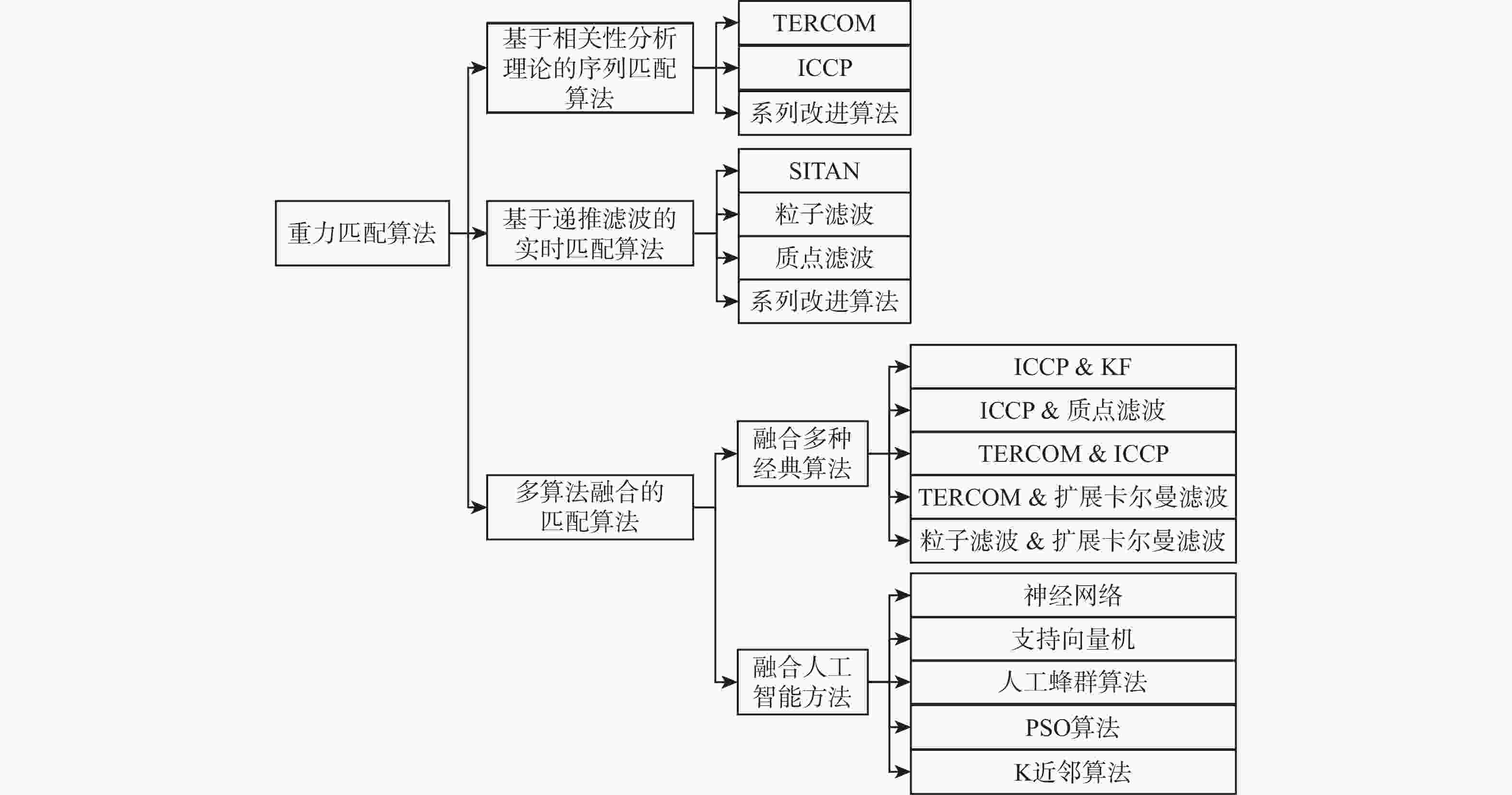
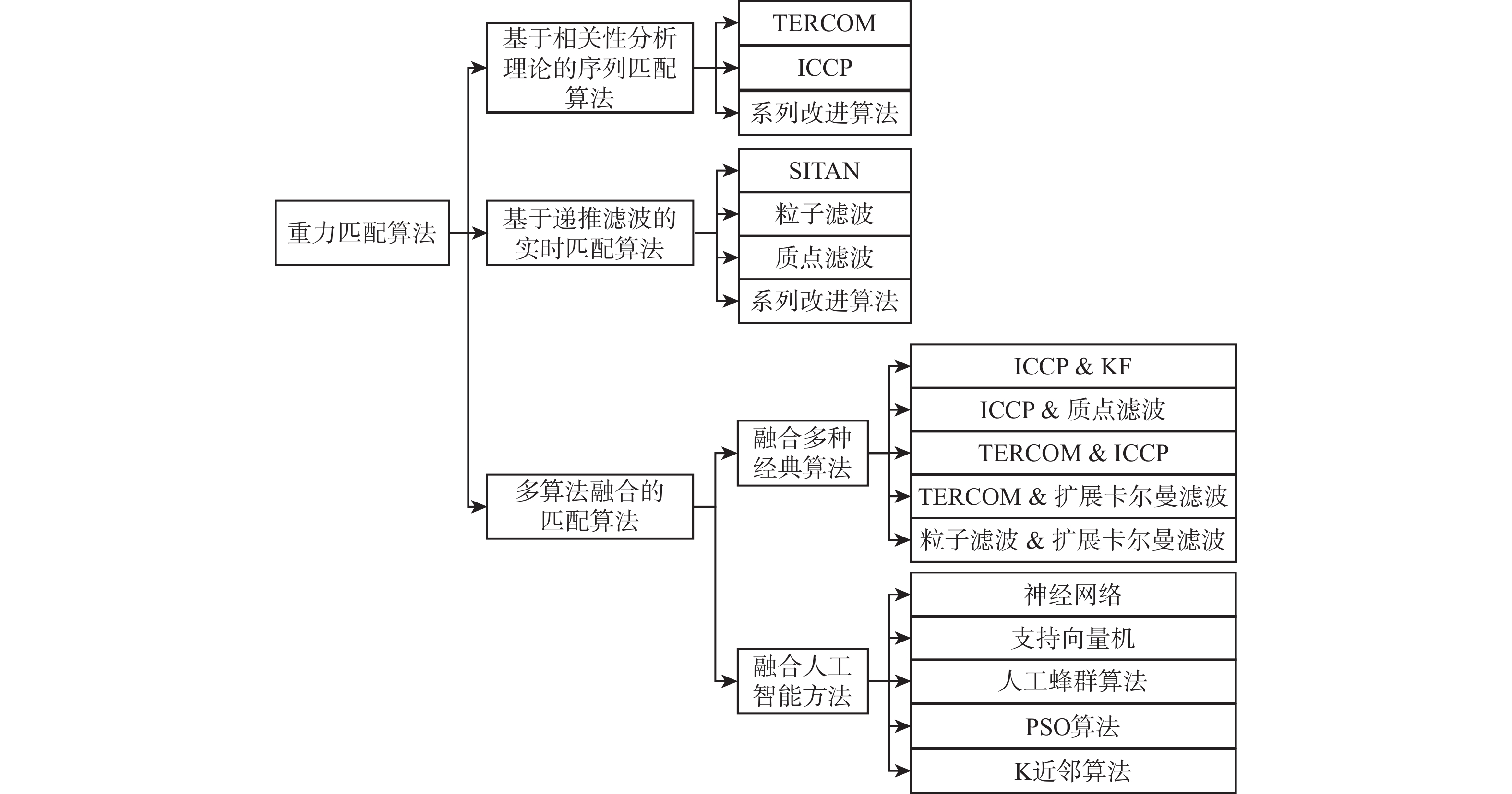
图 5 重力匹配算法分类及主要方法
Figure 5. Classification and main methods of gravity matching algorithms
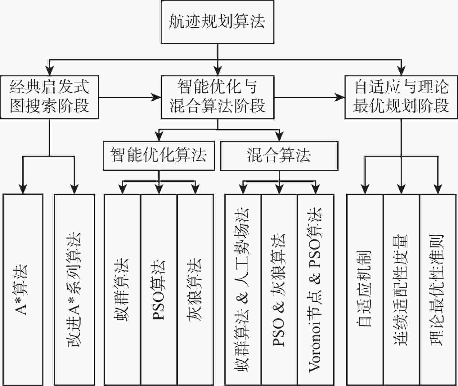
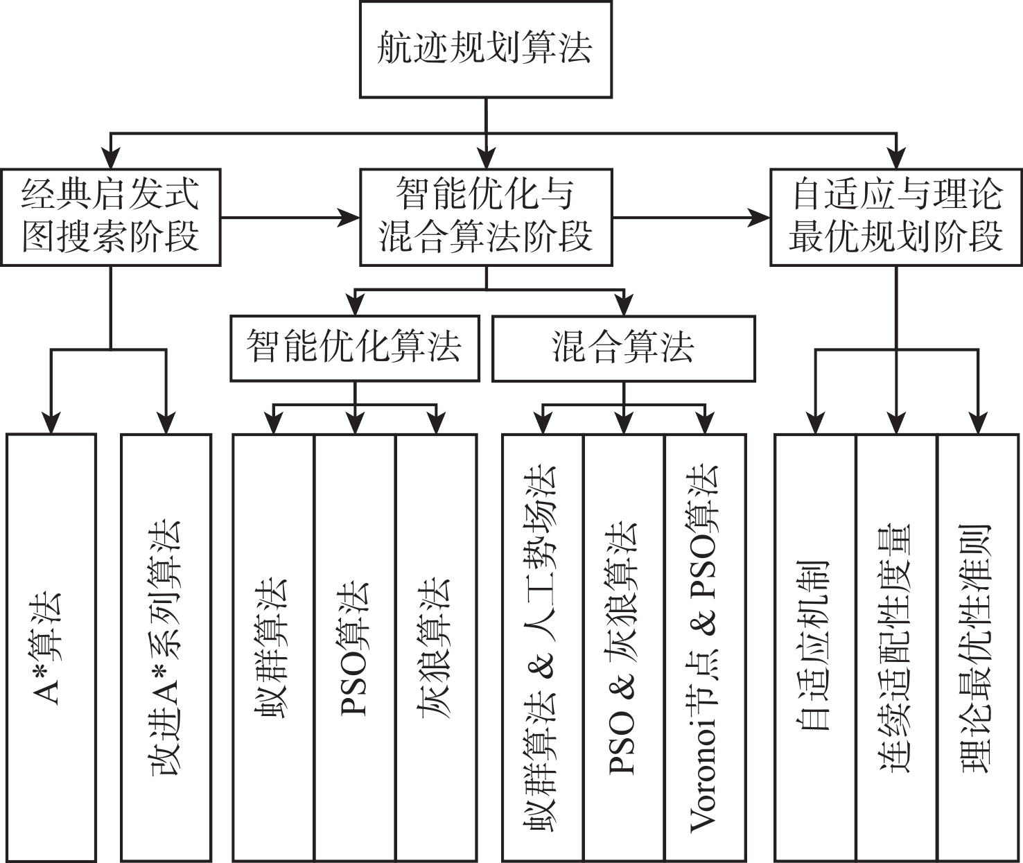
图 6 航迹规划算法发展阶段及主要方法
Figure 6. Development stages and main methods of route planning algorithms
表 1 不同插值算法性能对比
Table 1. Comparison of performance of different interpolation algorithms
插值算法 优势 劣势 IDW插值算法 原理简单,易于编程实现;计算效率高,适合大规模数据 对权重系数敏感,主观性强;易产生“牛眼”效应,结果不够平滑;无法估计插值误差 改进Shepard算法 继承IDW简单性,同时减少“牛眼”效应;通过半径搜索或权重修正,提高了局部拟合精度;计算量低于Kriging等统计方法 对搜索半径、拟合度等参数敏感;对数据边界区域的处理效果较差;不提供误差估计 Kriging插值算法 提供最优无偏估计,可给出插值误差;充分利用数据空间相关性,理论严密;可结合各向异性、趋势项等复杂模型 计算复杂,耗时长;需拟合变异函数,参数选择敏感;数据非平稳时效果下降 RBF插值算法 精确插值,光滑性好;适合不规则分布数据,灵活性高;多种核函数可选适应不同场特征 计算量大,速度慢;对核函数和光滑因子敏感;边缘区域误差较大 格林函数样条插值算法 物理意义明确;插值结果二阶光滑,适合连续物理场;可融合边界条件,自然处理数据稀疏区 格林函数构造复杂,涉及奇异性处理;大规模计算困难;对测量噪声敏感,易过拟合 曲线/曲面拟合法 整体拟合,趋势表达清晰,抑制噪声;参数少,模型稳定,易于解释;计算量小,适合大范围趋势提取 局部细节描述能力弱,易平滑掉真实重力异常;阶次选择主观,低阶欠拟合,高阶易振荡  下载: 导出CSV
表 2 典型重力场方向性特征参数对比分析
Table 2. Comparison and analysis of classical directional characteristic parameters
方向性特征参数 适用场景 优点 缺点 计算复杂度 各向同性系数[119] 评估区域整体的方向敏感程度,判断适配区是否在各方向上均适用;适用于适配区的初筛与方向性定性评估 首次将方向性定量纳入适配性评估;系数接近1时表明区域方向适应性好;理论基础严密,具有明确的物理意义 仅反映方向一致性,无法度量重力变化强度,需与其他特征联合使用;计算涉及频域变换,较为复杂 O(nlog2n)
(n为滑动窗口总数量)重力异常和向量差[120] 识别区域重力变化的主导方向;适合作为航迹规划中方向选择的参考依据;在重力变化各向异性明显的区域效果突出 可获取方向上的匹配度,克服标量参数无法反映方向性的局限;模值设计基于圆概率误差与3σ准则,理论依据充分 在重力变化剧烈但方向相互抵消的区域,模值可能偏小;矢量和方向对窗口形状敏感 O(n) 方向匹配率[121] 评估区域在多方向上的综合适配能力;适合需要全面评估区域各方向匹配性能的场景,尤其是航向不确定时的适配区选取 多方向梯度特征提取全面;CNN分类避免了主观阈值设定;实现方向适配性的定量评估 灰度级量化参数和方向数选择主观;特征计算涉及图像变换,复杂度较高 O(ndSL2)
(dS为Sobel算子的方向数量,L为灰度量化级数)曲率方向特征[122] 兼顾区域重力变化幅度与方向一致性的综合评估;适合对适配区进行方向鲁棒性筛选 曲率特征直接反映曲面几何特性,物理意义清晰;配合K-means聚类与形态学闭运算,兼顾区域连通性 需计算主曲率与高斯曲率,对重力数据平滑性敏感;方向一致性指标仅基于主曲率方向,未覆盖所有航向 O(nW2)
(W为滑动窗口边长)重力剖面相似性[123] 评估沿特定航向的匹配可行性,直接反映轨迹序列的独特性,适配于航迹规划中航向优选 直接反映沿航向的重力序列独特性,对匹配算法的实际效果预测更准确 剖面长度参数与权重参数需人工设定,对结果敏感 O(nW3) 方向梯度集中度[123] 评估特定航行方向上的重力变化强度与一致性,识别重力场方向性各向异性的区域 可量化任意给定航向的适配性;正交方向负相关特性可验证特征合理性 需针对每个航向单独计算,计算量随方向数量线性增长;Prewitt算子的方向分辨率有限 O(ndPW2)
(dP为Prewitt算子的方向
数量)
下载: 导出CSV
表 3 典型多算法融合的匹配算法对比分析
Table 3. Comparison and analysis of representative multi-algorithm fusion matching algorithms
多算法融合 匹配精度 实时性 参数敏感性 适用场景 TERCOM+EKF[184] 匹配精度依赖重力测量误差,1×10−5 m/s2的重力测量误差的平均定位误差为674.128 m,5×10−5 m/s2的重力测量误差的平均定位误差为 4379.98 m基于EKF的递推估计,可实时工作 对重力场粗糙度、初始误差、线性化误差及重力仪噪声均敏感 适用于中等粗糙度区域、重力仪精度较高和实时性要求较高的场景 TERCOM+ICCP[186] TERCOM出现明显误匹配且ICCP匹配结果较好时,平均定位误差由 1998.308 m降至870.44 m批处理算法,实时性较差 对TERCOM初始匹配质量和ICCP匹配精度敏感 适用于修正TERCOM误匹配的实时性要求不高的场景 PF+EKF[187] 全程平均定位误差达620.42 m;适配区的均方根误差:东向为281.504 m,北向为272.244 m 并行计算增加负载,但满足实时要求 依赖预计算阈值,但决策树自动选择方法降低调参难度 适用于各类重力场;存在较大测量噪声的长航时、连续水下导航场景 ICCP+BP神经网络[191] 与ICCP一致(未量化位置误差,仅提升计算速度) 相较于ICCP,迭代次数降82%,时间降低81% 对网络结构、学习率等超参数敏感,但文章未进行相关分析 适用于实时性要求高、计算资源受限的嵌入式平台 PF+PSO算法[195] 横穿等高线轨迹的平均定位误差为 1140.832 m,平行于等高线轨迹的平均定位误差为594.492 m采用滑动窗口递推,满足实时导航需求 缓解了标准PSO算法对初始参数敏感的固有缺陷,但依赖数字重力图的精度和重力仪实测数据的质量 适用于长航时重力辅助惯性导航场景,但不适用于重力场变化平缓或背景图分辨率与精度不足的区域 引入K近邻算法[196] 平均定位误差均小于800.064 m 每匹配点平均耗时5.87 s,可满足实时导航需求 对K值、搜索半径敏感,但抗噪性优于平均平方差相关算法 适用于存在较大测量噪声或重力场变化较平缓等困难条件的长航时、大航程航行任务
下载: 导出CSV
表 4 三类重力匹配算法的性能对比与适用场景
Table 4. Comparison of performance and suitable applications of three types of gravity matching algorithms
对比维度 序列匹配 实时滤波 多算法融合 实时性 属于批处理方法,需累积一定航迹长度后才能完成匹配,实时性较差 可逐点实时输出定位结果,实时性较好 实时性中等,通常包含批处理与递推两阶段,计算延迟较高 初始误差容忍度 TERCOM对初始误差不敏感;ICCP在惯导初始误差较大时,容易陷入局部最优解 对初始误差容忍度较低 对初始误差容忍度较高,常通过粗匹配阶段压制大初始误差 重力特征敏感性 对重力图分辨率和精度敏感,平坦区易误匹配 在平坦区易发散,易导致误匹配 相对鲁棒,可通过多算法互补缓解平坦区失配问题 重力测量噪声鲁棒性 对噪声较敏感,但长序列可在一定程度上抑制噪声影响 当重力测量噪声较大时,滤波过程极有可能发散 较好,多源信息融合可抑制噪声干扰 计算复杂度 计算量与搜索范围相关,会随搜索范围增大急剧增加 SITAN低,PF中等,PMF高(随网格分辨率指数增长) 高,需同时运行多个算法 适用场景 重力特征明显、初始位置误差大、对实时性要求不高的长航程任务 实时性要求高、机动航行、实时修正、初始误差较小的场景 高精度要求、允许较高计算资源、需兼顾大初始误差与复杂噪声的环境
下载: 导出CSV
-
[1] 王博, 周明龙. 水下重力辅助导航适配区选取的研究进展[J]. 导航定位学报, 2020, 8(3): 32-39.Wang B, Zhou M L. Perspective on matching area selection technology for underwater gravity aided navigation[J]. Journal of Navigation and Positioning, 2020, 8(3): 32-39(in Chinese). [2] 郑伟, 付腾达, 李钊伟, 等. 潜器水下重力匹配导航研究进展[J]. 科学技术与工程, 2022, 22(18): 7721-7734.Zheng W, Fu T D, Li Z W, et al. Progress of undersea gravity matching navigation[J]. Science Technology and Engineering, 2022, 22(18): 7721-7734(in Chinese). [3] Zhao S J, Dou Z Y, Zhu H Z, et al. ID2TM: a novel iterative double-cross domain-center transfer-matching method for underwater gravity-aided navigation[J]. IEEE Internet of Things Journal, 2025, 12(11): 15415-15423. [4] 黄谟涛, 欧阳永忠, 边少锋, 等. 美俄水下重力辅助惯性导航技术发展分析与思考[J]. 武汉大学学报(信息科学版), 2024, 49(11): 1977-1991.Huang M T, Ouyang Y Z, Bian S F, et al. Analysis and reflections on the development of underwater gravity-aided inertial navigation technology in the United States and Russia[J]. Geomatics and Information Science of Wuhan University, 2024, 49(11): 1977-1991(in Chinese). [5] Wang D, Wang B, Huang H Q, et al. A multisensor fusion method based on strict velocity for underwater navigation system[J]. IEEE Sensors Journal, 2023, 23(16): 18587-18598. [6] Mao N, Li A, Xu J N, et al. Adaptive gravity-aided inertial navigation based on characteristic analysis of marine gravity anomaly from satellite altimetry[J]. IEEE Transactions on Geoscience and Remote Sensing, 2024, 62: 5920813. [7] Sahoo A, Dwivedy S K, Robi P S. Advancements in the field of autonomous underwater vehicle[J]. Ocean Engineering, 2019, 181: 145-160. [8] Karmozdi A, Hashemi M, Salarieh H, et al. INS-DVL navigation improvement using rotational motion dynamic model of AUV[J]. IEEE Sensors Journal, 2020, 20(23): 14329-14336. [9] 孙明琦. 基于水下地貌的匹配导航算法研究[D]. 哈尔滨: 哈尔滨工程大学, 2018.Sun M Q. Research on matching navigation algorithm based on underwater topography[D]. Harbin: Harbin Engineering University, 2018(in Chinese). [10] 李姗姗. 水下重力辅助惯性导航的理论与方法研究[D]. 郑州: 解放军信息工程大学, 2010.Li S S. Research on theory and method of underwater gravity aided inertial navigation[D]. Zhengzhou: PLA Information Engineering University, 2010(in Chinese). [11] 张文君, 马腾, 李晔, 等. 水下地磁导航方法综述[J]. 哈尔滨工程大学学报, 2025, 46(12): 2583-2595.Zhang W J, Ma T, Li Y, et al. A summary of underwater geomagnetic navigation methods[J]. Journal of Harbin Engineering University, 2025, 46(12): 2583-2595(in Chinese). [12] 马明珠. 水下地磁辅助导航匹配算法研究[D]. 南京: 东南大学, 2019.Ma M Z. Research on underwater geomagnetic assisted navigation matching algorithm[D]. Nanjing: Southeast University, 2019(in Chinese). [13] Zhao S J, Zheng W, Li Z W, et al. Improving matching efficiency and out-of-domain positioning reliability of underwater gravity matching navigation based on a novel domain-center adaptive-transfer matching method[J]. IEEE Transactions on Instrumentation and Measurement, 2023, 72: 1001811. [14] Zou J S, Cai T J. Improved particle swarm optimization screening iterative algorithm in gravity matching navigation[J]. IEEE Sensors Journal, 2022, 22(21): 20866-20876. [15] Zhao S J, Zheng W, Li Z W, et al. A novel cross-line adaptive domain matching algorithm for underwater gravity aided navigation[J]. IEEE Geoscience and Remote Sensing Letters, 2024, 21: 7503605. [16] 吴庭涛, 郑伟, 尹文杰, 等. 地球卫星重力场模型及其应用研究进展[J]. 科学技术与工程, 2020, 20(25): 10117-10132.Wu T T, Zheng W, Yin W J, et al. Review of earth’s gravity field model and application from satellite[J]. Science Technology and Engineering, 2020, 20(25): 10117-10132(in Chinese). [17] 张驰. 重力辅助惯性导航的航迹规划与图像匹配方法研究[D]. 郑州: 战略支援部队信息工程大学, 2020.Zhang C. Research on track planning and image matching methods of gravity-aided inertial navigation[D]. Zhengzhou: Information Engineering University, 2020(in Chinese). [18] Sandwell D T, Smith W H F. Marine gravity anomaly from Geosat and ERS 1 satellite altimetry[J]. Journal of Geophysical Research: Solid Earth, 1997, 102(B5): 10039-10054. [19] Sandwell D T, Müller R D, Smith W H F, et al. New global marine gravity model from CryoSat-2 and Jason-1 reveals buried tectonic structure[J]. Science, 2014, 346(6205): 65-67. [20] Sandwell D T, Harper H, Tozer B, et al. Gravity field recovery from geodetic altimeter missions[J]. Advances in Space Research, 2021, 68(2): 1059-1072. [21] Andersen O B, Knudsen P, Kenyon S, et al. Global and Arctic marine gravity field from recent satellite altimetry (DTU13)[C]//Proceedings of the 76th EAGE Conference and Exhibition. Houten: EAGE, 2014: 1-5. [22] Andersen O B, Knudsen P. The DTU17 global marine gravity field: first validation results[C]//Proceedings of the Fiducial Reference Measurements for Altimetry. Berlin: Springer, 2020: 83-87. [23] Zhang S J, Zhou R S, Jia Y J, et al. Performance of HaiYang-2 altimetric data in marine gravity research and a new global marine gravity model NSOAS22[J]. Remote Sensing, 2022, 14(17): 4322. [24] Zhu C C, Guo J Y, Yuan J J, et al. SDUST2021GRA: global marine gravity anomaly model recovered from Ka-band and Ku-band satellite altimeter data[J]. Earth System Science Data, 2022, 14(10): 4589-4606. [25] 刘乾坤, 陈兆钰, 许可. 卫星测高重力与船测重力协同融合的全球高分辨率海洋重力场模型[J]. 空间科学学报, 2026, 46(3): 850-858.Liu Q K, Chen Z Y, Xu K. Global high-resolution marine gravity field model fused from altimetry-derived gravity and shipborne gravity[J]. Chinese Journal of Space Science, 2026, 46(3): 850-858(in Chinese). [26] Sandwell D, Garcia E, Soofi K, et al. Toward 1-mGal accuracy in global marine gravity from CryoSat-2, Envisat, and Jason-1[J]. The Leading Edge, 2013, 32(8): 892-899. [27] Sandwell D T, Smith W H F. Global marine gravity from retracked Geosat and ERS-1 altimetry: ridge segmentation versus spreading rate[J]. Journal of Geophysical Research: Solid Earth, 2009, 114(B1): 2008JB006008. [28] 聂琳娟, 超能芳, 金涛勇, 等. 卫星测高反演海洋重力异常的精度分析[J]. 测绘科学, 2016, 41(9): 1-6.Nie L J, Chao N F, Jin T Y, et al. Accuracy analysis of marine gravity anomaly inferred by satellite altimetry data[J]. Science of Surveying and Mapping, 2016, 41(9): 1-6(in Chinese). [29] 黄谟涛, 王瑞, 翟国君, 等. 多代卫星测高数据联合平差及重力场反演[J]. 武汉大学学报(信息科学版), 2007, 32(11): 988-993.Huang M T, Wang R, Zhai G J, et al. Integrated data processing for multi-satellite missions and recovery of marine gravity field[J]. Geomatics and Information Science of Wunan University, 2007, 32(11): 988-993(in Chinese). [30] 周瑞宸. 基于卫星测高的海洋垂直重力梯度反演研究[D]. 青岛: 山东科技大学, 2024: 28-30.Zhou R C. Study on inversion of vertical gravity gradient of ocean based on satellite altimetry[D]. Qingdao: Shandong University of Science and Technology, 2024: 28-30(in Chinese). [31] 张思慧, 吴云龙, 张毅, 等. 一种基于联合变分自编码器的卫星重力数据粗差探测方法研究[J]. 武汉大学学报(信息科学版), 2024, 49(6): 986-995.Zhang S H, Wu Y L, Zhang Y, et al. A gross error detection method of satellite gravity data based on joint variational autoencoder[J]. Geomatics and Information Science of Wuhan University, 2024, 49(6): 986-995(in Chinese). [32] 柳林涛, 梁星辉, 郎骏健, 等. 改进的函数滤波器及其在航空重力测量中的应用[J]. 测绘学报, 2023, 52(5): 706-713.Liu L T, Liang X H, Lang J J, et al. Improved function filter and its application in airborne gravimetry[J]. Acta Geodaetica et Cartographica Sinica, 2023, 52(5): 706-713(in Chinese). [33] 黄谟涛, 欧阳永忠, 邓凯亮, 等. 兼顾精度与分辨需求的海空重力测量误差分离与补偿方法[J]. 地球物理学报, 2018, 61(8): 3160-3169.Huang M T, Ouyang Y Z, Deng K L, et al. An error separation and compensation method for marine-airborne gravity measurement balancing accuracy and resolution requirements[J]. Chinese Journal of Geophysics, 2018, 61(8): 3160-3169(in Chinese). [34] 王皓, 熊盛青, 何涛, 等. 最小曲率模型的航空重力数据噪声压制方法研究[J]. 地球物理学报, 2024, 67(10): 3959-3972.Wang H, Xiong S Q, He T, et al. Noise suppression of airborne gravity data with minimum curvature model[J]. Chinese Journal of Geophysics, 2024, 67(10): 3959-3972(in Chinese). [35] 熊盛青, 王冠鑫, 罗锋, 等. 一种基于K-F滤波的航空重力数据的处理方法及系统: CN202510209565.9[P]. 2025-09-09.Xiong S Q, Wang G X, Luo F, et al. A method and system for processing airborne gravity data based on K-F filtering: CN202510209565.9[P]. 2025-09-09(in Chinese). [36] Guo J Y, Zhang H F, Zhang H Y, et al. Joint reprocessing method of multivintage shipborne gravity anomalies considering temporal error effects: a case study of the Philippine sea[J]. Geophysical Journal International, 2025, 242(3): 276. [37] 郭金运, 张鸿飞, 李真, 等. 多源船载重力异常数据的联合再处理: 以墨西哥湾为例[J]. 武汉大学学报(信息科学版), 2025, 50(7): 1277-1290.Guo J Y, Zhang H F, Li Z, et al. Joint reprocessing of multi-sources shipborne gravity anomalies: a case study of gulf of Mexico[J]. Geomatics and Information Science of Wuhan University, 2025, 50(7): 1277-1290(in Chinese). [38] Abulkhair M, Zaki A, Elhadary A, et al. Optimizing shipborne gravity data around Egypt for enhanced geomatics applications[J]. The Egyptian Journal of Remote Sensing and Space Sciences, 2026, 29(1): 104-119. [39] Bako M, Kusche J. Evaluation and homogenization of a marine gravity database from shipborne and satellite altimetry-derived gravity data over the coastal region of Nigeria[J]. Journal of Applied Geodesy, 2025, 19(2): 175-189. [40] 张敬伟. 布尔莎模型坐标转换适用范围及精度分析[J]. 测绘与空间地理信息, 2013, 36(1): 175-176.Zhang J W. The using range and precision analysis for bursa model coordinate conversion[J]. Geomatics & Spatial Information Technology, 2013, 36(1): 175-176(in Chinese). [41] 欧阳永忠. 海空重力测量数据处理关键技术研究[D]. 武汉: 武汉大学, 2013.Ouyang Y Z. On key technologies of data processing for air-sea gravity surveys[D]. Wuhan: Wuhan University, 2013(in Chinese). [42] 束蝉方, 李斐, 张利明. 基于EGM2008重力场模型的局部高程基准统一[J]. 地球物理学进展, 2011, 26(2): 438-442.Shu C F, Li F, Zhang L M. Local height datum unification using EGM2008[J]. Progress in Geophysics, 2011, 26(2): 438-442(in Chinese). [43] 劳浩瑜, 张兴福, 孙炜程, 等. 多源重力场模型融合方法与精度分析[J]. 地球物理学进展, 2025, 40(5): 1905-1918.Lao H Y, Zhang X F, Sun W C, et al. Combination methods and precision analysis of multi-source global geopotential models[J]. Progress in Geophysics, 2025, 40(5): 1905-1918(in Chinese). [44] 刘鑫宇, 李姗姗, 张盼盼, 等. 顾及剩余地形影响的局部高程基准统一方法[J]. 武汉大学学报(信息科学版), 2025, 50(5): 898-906.Liu X Y, Li S S, Zhang P P, et al. Local vertical datum unification method considering effect of residual terrain[J]. Geomatics and Information Science of Wuhan University, 2025, 50(5): 898-906(in Chinese). [45] 徐卫明, 舒嵘. 利用GPS接收机实现多传感器同步工作的两种方法[J]. 遥感技术与应用, 2003, 18(6): 404-406.Xu W M, Shu R. Two methods of multi-sensor synchronization with GPS receiver[J]. Remote Sensing Technology and Application, 2003, 18(6): 404-406(in Chinese). [46] Jiang M F, Xu K, Liu Y L, et al. Estimating the time tag bias of HY-2A radar altimeter and its application to dual-frequency ionosphere correction[J]. Marine Geodesy, 2017, 40(6): 361-377. [47] 吴涛, 朱建良, 周维. 基于补偿GNSS滞后的实时外推时间配准方法[J]. 淮阴工学院学报, 2022, 31(1): 54-59.Wu T, Zhu J L, Zhou W. Real-time extrapolation time registration method based on compensating GNSS lag[J]. Journal of Huaiyin Institute of Technology, 2022, 31(1): 54-59(in Chinese). [48] Fan X, Guo J Y, Zhang H Y, et al. A two-step method of crossover adjustment for satellite altimeter data[J]. Advances in Space Research, 2025, 75(1): 219-232. [49] 刘晓刚, 闫志闯, 孙文, 等. 确定地球重力场模型的最小二乘配置法与调和分析法的精度评析[J]. 地球物理学进展, 2014, 29(1): 46-50.Liu X G, Yan Z C, Sun W, et al. Precision evaluation and analysis of least squares collocation method and spherical harmonic analysis method in the determination of the Earth’s gravity field model[J]. Progress in Geophysics, 2014, 29(1): 46-50(in Chinese). [50] 潘宗鹏, 王伟, 祖安然. 多源重力场信息融合处理方法[J]. 测绘科学技术学报, 2013, 30(3): 236-240.Pan Z P, Wang W, Zu A R. Fusion methods of multi-source gravity field information[J]. Journal of Geomatics Science and Technology, 2013, 30(3): 236-240(in Chinese). [51] 翟振和, 孙中苗. 基于最小二乘配置的航空和地面重力数据融合处理[J]. 测绘科学与工程, 2008(1): 10-14.Zhai Z H, Sun Z M. Combining airborne gravity data and terrestrial gravity data based on least squares collocation[J]. Geomatics Science and Engineering, 2008(1): 10-14(in Chinese). [52] Ophaug V, Gerlach C. On the equivalence of spherical splines with least-squares collocation and Stokes’s formula for regional geoid computation[J]. Journal of Geodesy, 2017, 91(11): 1367-1382. [53] Märdla S, Ellmann A, Ågren J, et al. Regional geoid computation by least squares modified Hotine’s formula with additive corrections[J]. Journal of Geodesy, 2018, 92(3): 253-270. [54] 李芳明. 水下重力辅助定位及重力图导航适配性研究[D]. 哈尔滨: 哈尔滨工程大学, 2020.Li F M. Research on underwater gravity aided positioning and gravity map navigability analysis[D]. Harbin: Harbin Engineering University, 2020(in Chinese). [55] 黄谟涛, 欧阳永忠, 翟国君, 等. 融合多源重力数据的Tikhonov正则化配置法[J]. 海洋测绘, 2013, 33(3): 6-12.Huang M T, Ouyang Y Z, Zhai G J, et al. Tikhonov regularization collocation for multi-source gravity data fusion processing[J]. Hydrographic Surveying and Charting, 2013, 33(3): 6-12(in Chinese). [56] 高新兵, 李姗姗, 李海, 等. 点质量模型与最小二乘配置在多源重力数据融合中的应用[J]. 大地测量与地球动力学, 2013, 33(1): 145-149.Gao X B, Li S S, Li H, et al. Application of point mass model and least square collocation in multi-source gravity data fusion[J]. Journal of Geodesy and Geodynamics, 2013, 33(1): 145-149(in Chinese). [57] 孙文, 吴晓平, 王庆宾, 等. 基于方差分量估计的正则化配置法及其在多源重力数据融合中的应用[J]. 武汉大学学报(信息科学版), 2016, 41(8): 1087-1092.Sun W, Wu X P, Wang Q B, et al. Normalized collocation based on variance component estimate and its application in multi-source gravity data fusion[J]. Geomatics and Information Science of Wuhan University, 2016, 41(8): 1087-1092(in Chinese). [58] Sampietro D, Capponi M, Mansi A H, et al. Space-Wise approach for airborne gravity data modelling[J]. Journal of Geodesy, 2017, 91(5): 535-545. [59] 吴怿昊, 罗志才. 融合多源数据的局部重力场建模中线性化误差的研究[J]. 大地测量与地球动力学, 2016, 36(6): 476-480.Wu Y H, Luo Z C. The research on linearization errors in regional gravity field modeling based on heterogeneous data sets[J]. Journal of Geodesy and Geodynamics, 2016, 36(6): 476-480(in Chinese). [60] 吴健生, 刘苗. 基于小波的位场数据融合[J]. 同济大学学报(自然科学版), 2008, 36(8): 1133-1137.Wu J S, Liu M. Potential field data fusion based on wavelet multi-resolution decomposition[J]. Journal of Tongji University (Natural Science), 2008, 36(8): 1133-1137(in Chinese). [61] Bolkas D, Fotopoulos G, Braun A. Comparison and fusion of satellite, airborne, and terrestrial gravity field data using wavelet decomposition[J]. Journal of Surveying Engineering, 2016, 142(2): 04015010. [62] Bai Y L, Dong D D, Wu S G, et al. A wavelet transformation approach for multi-source gravity fusion: applications and uncertainty tests[J]. Journal of Applied Geophysics, 2016, 128: 18-30. [63] Ma L, Song H B, Bai Y L, et al. Gravity data fusion using wavelet transform and window weighting: a case study in the Ross Sea of Antarctica[J]. Acta Geophysica, 2025, 73(1): 187-201. [64] Chen X, Kong X X, Zhou R S, et al. Fusion of altimetry-derived model and ship-borne data in preparation of high-resolution marine gravity determination[J]. Geophysical Journal International, 2024, 236(3): 1262-1274. [65] Lin M, Denker H, Müller J. Regional gravity field modeling using free-positioned point masses[J]. Studia Geophysica et Geodaetica, 2014, 58(2): 207-226. [66] Kern M. An analysis of the combination and downward continuation of satellite, airborne and terrestrial gravity data[D]. Calgary: University of Calgary, 2003. [67] Tenzer R, Klees R. The choice of the spherical radial basis functions in local gravity field modeling[J]. Studia Geophysica et Geodaetica, 2008, 52(3): 287-304. [68] 黄谟涛, 翟国君, 管铮, 等. 海洋重力场测定及其应用[M]. 北京: 测绘出版社, 2005: 266-296.Huang M T, Zhai G J, Guan Z, et al. Determination and application of marine gravity field[M]. Beijing: Sino Maps Press, 2005: 266-296(in Chinese). [69] 李建成. 地球重力场逼近理论与中国2000似大地水准面的确定[M]. 武汉: 武汉大学出版社, 2003: 30-37.Li J C. Approximation theory of earth gravity field and determination of China 2000 quasi-geoid[M]. Wuhan: Wuhan University Press, 2003: 30-37(in Chinese). [70] 黄谟涛, 欧阳永忠, 刘敏, 等. 融合海域多源重力数据的正则化点质量方法[J]. 武汉大学学报(信息科学版), 2015, 40(2): 170-175.Huang M T, Ouyang Y Z, Liu M, et al. Regularization of point-mass model for multi-source gravity data fusion processing[J]. Geomatics and Information Science of Wuhan University, 2015, 40(2): 170-175(in Chinese). [71] 成怡. 多源海洋重力数据融合技术研究[D]. 哈尔滨: 哈尔滨工程大学, 2008.Cheng Y. A study on heterogeneous marine gravity data combination technology[D]. Harbin: Harbin Engineering University, 2008(in Chinese). [72] Wittwer T. Regional gravity field modelling with radial basis functions[D]. Delft: Delft University of Technology, 2009. [73] Klees R, Tenzer R, Prutkin I, et al. A data-driven approach to local gravity field modelling using spherical radial basis functions[J]. Journal of Geodesy, 2008, 82(8): 457-471. [74] Bentel K, Schmidt M. Combining different types of gravity observations in regional gravity modeling in spherical radial basis functions[C]//Proceedings of the VIII Hotine-Marussi Symposium on Mathematical Geodesy. Berlin: Springer, 2015: 115-120. [75] 吴怿昊, 罗志才, 周波阳. 基于泊松小波径向基函数融合多源数据的局部重力场建模[J]. 地球物理学报, 2016, 59(3): 852-864.Wu Y H, Luo Z C, Zhou B Y. Regional gravity modeling based on heterogeneous data sets by using Poisson wavelets radial basis functions[J]. Chinese Journal of Geophysics, 2016, 59(3): 852-864(in Chinese). [76] Mahbuby H, Safari A, Foroughi I. Local gravity field modeling using spherical radial basis functions and a genetic algorithm[J]. Comptes Rendus Géoscience, 2017, 349(3): 106-113. [77] 吴怿昊, 何秀凤, 罗志才, 等. 基于航空重力梯度数据重建高分辨率局部重力场的径向基函数方法[J]. 地球物理学报, 2024, 67(5): 1913-1926.Wu Y H, He X F, Luo Z C, et al. The approach for high-resolution local gravity field recovery from airborne gravity gradient data based on radial basis functions[J]. Chinese Journal of Geophysics, 2024, 67(5): 1913-1926(in Chinese). [78] Kim J, Lee J K, Lee K M. Accurate image super-resolution using very deep convolutional networks[C]//Proceedings of the IEEE Conference on Computer Vision and Pattern Recognition. Piscataway: IEEE Press, 2016: 1646-1654. [79] Deudon M, Kalaitzis A, Goytom I, et al. HighRes-net: recursive fusion for multi-frame super-resolution of satellite imagery[EB/OL]. (2020-02-15)[2026-04-05]. https://doi.org/10.48550/arXiv.2002.06460. [80] Zhu C C, Guo J Y, Yuan J J, et al. Refining altimeter-derived gravity anomaly model from shipborne gravity by multi-layer perceptron neural network: a case in the South China Sea[J]. Remote Sensing, 2021, 13(4): 607. [81] Alaofin O, Zhang Y, Sharma J, et al. Cross-modality super-resolution of satellite gravity data for geophysical exploration[C]//Proceedings of the IEEE International Geoscience and Remote Sensing Symposium. Piscataway: IEEE Press, 2022: 7539-7542. [82] 王逸宸, 柳林涛, 许厚泽. 利用卷积自编码器重建含噪重力数据[J]. 武汉大学学报(信息科学版), 2022, 47(4): 543-550.Wang Y C, Liu L T, Xu H Z. Noisy gravity data reconstruction using the convolutional autoencoder[J]. Geomatics and Information Science of Wuhan University, 2022, 47(4): 543-550(in Chinese). [83] Xiao C J, Guo J Y, Zhu C C, et al. Refining satellite Altimetry-Derived gravity anomaly model with shipborne gravity using multilayer perceptron neural networks[J]. Scientific Reports, 2025, 15: 19467. [84] Zhang Y. Deep learning based super resolution of gravity data for geophysical exploration[D]. Baton Rouge: Louisiana State University, 2021. [85] 孙明智, 冯伟, 安德超, 等. 基于多源数据和卷积神经网络的海洋重力异常反演[J]. 地球物理学报, 2025, 68(11): 4145-4156.Sun M Z, Feng W, An D C, et al. Marine gravity anomaly recovery based on multi-source data and convolutional neural network[J]. Chinese Journal of Geophysics, 2025, 68(11): 4145-4156(in Chinese). [86] Li Q Q, Zhai Z H, Bao L F, et al. A convolutional neural network to optimize multi-mission satellite altimeter fusion for improving the marine gravity field[J]. Earth, Planets and Space, 2024, 76(1): 129. [87] Jia B D, Sun J, Geng X F, et al. Super-resolution reconstruction of gravity data using semi-supervised dual regression learning[J]. Remote Sensing, 2026, 18(3): 453. [88] Jia R C, Yang Y C, Wang Q B, et al. Multi-source geodetic data fusion using a physically informed swin transformer for high-resolution gravity field recovery: a case study of the South China Sea[J]. Journal of Marine Science and Engineering, 2026, 14(4): 403. [89] Reyes O, Cano A, Fardoun H M, et al. A locally weighted learning method based on a data gravitation model for multi-target regression[J]. International Journal of Computational Intelligence Systems, 2018, 11(1): 282-295. [90] 徐遵义, 姜玉祥, 赵亮, 等. 改进的Shepard算法及其在重力异常插值中的应用[J]. 武汉大学学报(信息科学版), 2010, 35(4): 477-480.Xu Z Y, Jiang Y X, Zhao L, et al. Improved Shepard method and its application in gravity field data interpolation[J]. Geomatics and Information Science of Wuhan University, 2010, 35(4): 477-480(in Chinese). [91] Hansen R O. Interpretive gridding by anisotropic Kriging[J]. Geophysics, 1993, 58(10): 1491-1497. [92] Wright G B. Radial basis function interpolation: numerical and analytical developments[D]. Boulder: University of Colorado, 2003. [93] Wessel P. A general-purpose Green’s function-based interpolator[J]. Computers & Geosciences, 2009, 35(6): 1247-1254. [94] Wessel P, Bercovici D. Interpolation with splines in tension: a Green’s function approach[J]. Mathematical Geology, 1998, 30(1): 77-93. [95] 韩雨蓉. 水下导航重力匹配算法研究[D]. 北京: 北京理工大学, 2017.Han Y R. Research on gravity matching algorithm for underwater navigation[D]. Beijing: Beijing Institute of Technology, 2017(in Chinese). [96] 吴太旗, 黄谟涛, 欧阳永忠, 等. 高精度海洋重力异常格网插值技术研究[J]. 测绘科学, 2008, 33(5): 70-72.Wu T Q, Huang M T, Ouyang Y Z, et al. The study of high precision interpolation technology in marine gravity anomaly[J]. Science of Surveying and Mapping, 2008, 33(5): 70-72(in Chinese). [97] 刘晓刚, 吴晓平, 王宝军, 等. 卫星重力梯度数据的网格化方法研究[J]. 大地测量与地球动力学, 2010, 30(6): 60-65.Liu X G, Wu X P, Wang B J, et al. Study on gridding methods of satellite gravity gradient data[J]. Journal of Geodesy and Geodynamics, 2010, 30(6): 60-65(in Chinese). [98] 李振海, 汪海洪. 重力数据网格化方法比较[J]. 大地测量与地球动力学, 2010, 30(1): 140-144.Li Z H, Wang H H. Comparison among methods for gravity data gridding[J]. Journal of Geodesy and Geodynamics, 2010, 30(1): 140-144(in Chinese). [99] 江东, 王庆宾, 王凯. 重力场精化的空间插值方法研究[C]//中国测绘学会学术年会会议论文集. 北京: 中国测绘学会, 2010: 181-185.Jiang D, Wang Q B, Wang K. Research on spatial interpolation methods for gravity field refinement[C]//Proceedings of the China Society of Geodesy, Photogrammetry and Cartography Academic Annual Conference. Beijing: China Society of Geodesy, Photogrammetry and Cartography, 2010: 181-185(in Chinese). [100] 周文健, 高春峰, 魏国, 等. 空间插值算法在海洋重力基准图构建中的适用性分析[C]//中国惯性技术学会科技工作者研讨会会议论文集——新型惯性元件与先进导航技术. 北京: 中国惯性技术学会, 2023: 133-142.Zhou W J, Gao C F, Wei G, et al. Applicability analysis of spatial interpolation algorithms in marine gravity reference map construction[C]//Proceedings of the Science and Technology Workers Symposium of Chinese Society of Inertial Technology-New Inertial Components and Advanced Navigation Technology. Beijing: Chinese Society of Inertial Technology, 2023: 133-142(in Chinese). [101] While J, Biegert E, Jackson A. Interpolation of gravity and gravity gradient data by using the generalized sampling expansion: theory[J]. Geophysics, 2008, 73(2): I11-I21. [102] 刘繁明, 姚剑奇, 荆心. 由小波与随机采样提升重力场插值精度的策略[J]. 大地测量与地球动力学, 2015, 35(6): 948-952.Liu F M, Yao J Q, Jing X. A strategy for upgrading the interpolation accuracy of gravity map based on wavelet analysis[J]. Journal of Geodesy and Geodynamics, 2015, 35(6): 948-952(in Chinese). [103] 文超斌, 王跃钢, 郭志斌, 等. 重力辅助导航高斯插值精化算法[J]. 测绘学报, 2015, 44(1): 13-18.Wen C B, Wang Y G, Guo Z B, et al. Gravity aided navigation precise algorithm with Gauss spline interpolation[J]. Acta Geodaetica et Cartographica Sinica, 2015, 44(1): 13-18(in Chinese). [104] 任强强, 王跃钢, 文超斌, 等. 局部连续场下重力基准图插值优选算法[J]. 大地测量与地球动力学, 2016, 36(3): 198-201.Ren Q Q, Wang Y G, Wen C B, et al. Interpolation optimization algorithm for gravity reference map in local anomaly fields[J]. Journal of Geodesy and Geodynamics, 2016, 36(3): 198-201(in Chinese). [105] 曾敏, 汪振华, 邓凯亮, 等. 借助EGM2008的海域重力异常反距离加权插值算法[J]. 海洋测绘, 2018, 38(2): 5-7.Zeng M, Wang Z H, Deng K L, et al. An inverse distance interpolation algorithm of marine gravity anomaly uniting EGM2008 gravity field model[J]. Hydrographic Surveying and Charting, 2018, 38(2): 5-7(in Chinese). [106] Sarzeaud O, LeQuentrec-Lalancette M F, Rouxel D. Optimal interpolation of gravity maps using a modified neural network[J]. Mathematical Geosciences, 2009, 41(4): 379-395. [107] 佘雅文, 付广裕. 基于循环神经网络的重力异常数据推估研究[J]. 大地测量与地球动力学, 2021, 41(3): 234-237.She Y W, Fu G Y. Estimation of gravity anomaly data based on recurrent neural network[J]. Journal of Geodesy and Geodynamics, 2021, 41(3): 234-237(in Chinese). [108] 黄子炎, 王庆宾, 李锁柱, 等. 利用Kmeans-RBF神经网络提高重力格网化数据精度[J]. 海洋测绘, 2021, 41(4): 43-47.Huang Z Y, Wang Q B, Li S Z, et al. Using Kmeans-RBF neural network to improve the accuracy of grid gravity data[J]. Hydrographic Surveying and Charting, 2021, 41(4): 43-47(in Chinese). [109] Mao N, Li A, Xu J N, et al. Marine gravity anomaly from satellite altimetry: interpolation and matching navigation[J]. IEEE Transactions on Geoscience and Remote Sensing, 2023, 61: 5918919. [110] 谢心和, 赵东明, 刘长青. 一种基于PSO-BP神经网络的重力数据插值方法[J]. 测绘与空间地理信息, 2023, 46(11): 26-29.Xie X H, Zhao D M, Liu C Q. A gravity data interpolation method based on PSO-BP neural network[J]. Geomatics & Spatial Information Technology, 2023, 46(11): 26-29(in Chinese). [111] 谢心和, 赵东明, 刘长青. Legendre多项式神经网络在重力数据插值中的应用[J]. 测绘与空间地理信息, 2023, 46(12): 19-23.Xie X H, Zhao D M, Liu C Q. Application of Legendre polynomial neural network in gravity data interpolation[J]. Geomatics & Spatial Information Technology, 2023, 46(12): 19-23(in Chinese). [112] Feng T, Li T J. High-resolution reconstruction of gravity reference map via BP-boosting-driven interpolation methods[C]//Proceedings of the 3rd International Conference on Computer Graphics and Image Processing. Piscataway: IEEE Press, 2025: 39-44. [113] 於青凤, 熊杰, 龚永琪. 基于扩散模型的重力数据网格化方法[J]. 地质论评, 2025, 99(6): 1-11.Yu Q F, Xiong J, Gong Y Q. Gridding method of gravity data based on diffusion model[J]. Geological Review, 2025, 99(6): 1-11(in Chinese). [114] Zhang S Q, Gao L N, Zhou F H, et al. Asymmetric dual-branch network for gravity anomaly reference map super-resolution in underwater gravity matching navigation[J]. IEEE Transactions on Instrumentation and Measurement, 2025, 74: 8512416. [115] 李艳, 刘繁明. 重力图的可导航性分析[J]. 应用科技, 2010(12): 60-63.Li Y, Liu F M. Navigability analysis of gravity map[J]. Applied Science and Technology, 2010(12): 60-63(in Chinese). [116] 李姗姗, 吴晓平, 张传定, 等. 我国重力场新的统计特征参数的计算分析[J]. 地球物理学报, 2010, 53(5): 1099-1108.Li S S, Wu X P, Zhang C D, et al. Calculation and analysis of the new statistical character parameters of gravity field in China[J]. Chinese Journal of Geophysics, 2010, 53(5): 1099-1108(in Chinese). [117] Liu F M, Li F M, Jing X. Navigability analysis of local gravity map with projection pursuit-based selection method by using gravitation field algorithm[J]. IEEE Access, 2019, 7: 75873-75889. [118] 马越原, 欧阳永忠, 黄谟涛, 等. 基于重力场特征参数信息熵的适配区选择方法[J]. 中国惯性技术学报, 2016, 24(6): 763-768.Ma Y Y, Ouyang Y Z, Huang M T, et al. Selection method for gravity-field matchable area based on information entropy of characteristic parameters[J]. Journal of Chinese Inertial Technology, 2016, 24(6): 763-768(in Chinese). [119] Wang B, Zhu Y W, Deng Z H, et al. The gravity matching area selection criteria for underwater gravity-aided navigation application based on the comprehensive characteristic parameter[J]. IEEE/ASME Transactions on Mechatronics, 2016, 21(6): 2935-2943. [120] Wang B, Zhou M L, Deng Z H, et al. Sum vector-difference-based matching area selection method for underwater gravity-aided navigation[J]. IEEE Access, 2019, 7: 123616-123624. [121] Ma Z X, Wang B, Wang X Y, et al. Gravitational texture feature based directional adaptability analysis method for gravity-aided navigation[J]. IEEE/ASME Transactions on Mechatronics, 2025, 30(6): 6397-6406. [122] Wang M C, Zheng W, Zhao S J, et al. A novel curvature directional feature-based matching area clustering method for underwater gravity-aided navigation[J]. IEEE Transactions on Instrumentation and Measurement, 2025, 74: 8514710. [123] Zhang W Z, Wang Y, Zhao S W, et al. A gravity matching adaptability analysis method based on gravity directional characteristics[J]. IEEE Sensors Journal, 2026, 26(7): 10731-10744. [124] Xiong L, Li K H, Tang J Q, et al. Research on matching area selection criteria for gravity gradient navigation based on principal component analysis and analytic hierarchy process[C]//Proceedings of the Ninth International Symposium on Multispectral Image Processing and Pattern Recognition. Bellingham: SPIE, 2015, 9815: 981519. [125] 李钊伟, 郑伟, 房静, 等. 基于新型主成分加权平均归一化法优选水下重力匹配导航适配区[J]. 地球物理学报, 2019, 62(9): 3269-3278.Li Z W, Zheng W, Fang J, et al. Optimizing suitability area of underwater gravity matching navigation based on a new principal component weighted average normalization method[J]. Chinese Journal of Geophysics, 2019, 62(9): 3269-3278(in Chinese). [126] 张辰, 马林, 张桂敏, 等. 一种新的重力辅助导航海区适配性分析方法[C]//中国惯性技术学会第七届学术年会会议论文集. 北京: 中国惯性技术学会, 2015: 130-135.Zhang C, Ma L, Zhang G M, et al. A new method for sea area suitability analysis of gravity-aided navigation[C]//Proceedings of the 7th Academic Annual Conference of Chinese Society of Inertial Technology. Beijing: Chinese Society of Inertial Technology, 2015: 130-135(in Chinese). [127] 蔡体菁, 陈鑫巍. 基于层次分析法的重力匹配区域选择准则[J]. 中国惯性技术学报, 2013, 21(1): 93-96.Cai T J, Chen X W. Selection criterion based on analytic hierarchy process for matching region in gravity aided INS[J]. Journal of Chinese Inertial Technology, 2013, 21(1): 93-96(in Chinese). [128] 马越原, 欧阳永忠, 曲政豪, 等. 基于模糊决策理论的重力辅助导航区域选择方法[J]. 海洋测绘, 2016, 36(6): 7-10.Ma Y Y, Ouyang Y Z, Qu Z H, et al. Selection criteria of gravity aided navigation area based on fuzzy decision theory[J]. Hydrographic Surveying and Charting, 2016, 36(6): 7-10(in Chinese). [129] 徐晓苏, 汤郡郡, 张涛, 等. 基于熵值法赋权灰色关联决策的地形辅助导航适配区选择[J]. 中国惯性技术学报, 2015, 23(2): 201-206.Xu X S, Tang J J, Zhang T, et al. Selection for matching area in terrain aided navigation based on entropy-weighted grey correlation decision-making[J]. Journal of Chinese Inertial Technology, 2015, 23(2): 201-206(in Chinese). [130] 宫京, 张崇猛, 周贤高, 等. 一种基于因子分析的重力适配区域选取方法[J]. 中国惯性技术学报, 2019, 27(6): 732-737.Gong J, Zhang C M, Zhou X G, et al. Selection method of gravity adaptive region based on factor analysis[J]. Journal of Chinese Inertial Technology, 2019, 27(6): 732-737(in Chinese). [131] 肖云, 张锦柏, 曹杰, 等. 多属性决策理论的重力匹配导航适配性分析[J]. 武汉大学学报(信息科学版), 2023, 48(7): 1089-1099.Xiao Y, Zhang J B, Cao J, et al. Suitability analysis of gravity matching navigation based on multiple attribute decision making theory[J]. Geomatics and Information Science of Wuhan University, 2023, 48(7): 1089-1099(in Chinese). [132] 陈垲宁, 肖云, 张锦柏, 等. 水下重力匹配导航适配性评价方法比较研究[J]. 大地测量与地球动力学, 2024, 44(7): 737-743.Chen K N, Xiao Y, Zhang J B, et al. Comparison of adaptive evaluation methods of underwater gravity matching navigation[J]. Journal of Geodesy and Geodynamics, 2024, 44(7): 737-743(in Chinese). [133] 张勇刚, 张硕, 李宁, 等. 基于深度特征探索的重力适配区选择算法[J]. 中国惯性技术学报, 2025, 33(6): 546-558.Zhang Y G, Zhang S, Li N, et al. Selection algorithm for gravity matching region based on deep feature exploration[J]. Journal of Chinese Inertial Technology, 2025, 33(6): 546-558(in Chinese). [134] Tang J Q, Xiong L, Li K H, et al. Research on matching area selection based on multiple features fusion of full tensor gravity gradient[C]//Proceedings of the Automatic Target Recognition and Navigation. Bellingham: SPIE, 2015, 9812: 98120F-5-98120F-6. [135] 程力, 张雅杰, 蔡体菁. 重力辅助导航匹配区域选择准则[J]. 中国惯性技术学报, 2007, 15(5): 559-563.Cheng L, Zhang Y J, Cai T J. Selection criterion for matching area in gravity aided navigation[J]. Journal of Chinese Inertial Technology, 2007, 15(5): 559-563(in Chinese). [136] Li K H, Xiong L, Cheng L, et al. The research of matching area selection criterion for gravity gradient aided navigation[C]//Proceedings of the Pattern Recognition. Berlin: Springer, 2014: 21-30. [137] 徐辰龙, 黄玉龙, 王钊, 等. 基于Haar小波变换的重力场方向性适配区选取方法[J]. 中国惯性技术学报, 2024, 32(9): 907-917.Xu C L, Huang Y L, Wang Z, et al. Gravity field directionality matching area selection method based on Haar wavelet transform[J]. Journal of Chinese Inertial Technology, 2024, 32(9): 907-917(in Chinese). [138] Wang C L, Wang B, Deng Z H, et al. A co-occurrence matrix-based matching area selection algorithm for underwater gravity-aided inertial navigation[J]. IET Radar, Sonar & Navigation, 2021, 15(3): 250-260. [139] 马旭东, 闫利, 乔永杰. 重力异常辅助惯性导航中匹配区提取方法[J]. 测绘科学技术学报, 2009, 26(6): 399-402.Ma X D, Yan L, Qiao Y J. Extraction method of matching area in gravity anomaly aided inertial navigation[J]. Journal of Geomatics Science and Technology, 2009, 26(6): 399-402(in Chinese). [140] Wang B, Li T J, Deng Z H, et al. Wavelet transform based morphological matching area selection for underwater gravity gradient-aided navigation[J]. IEEE Transactions on Vehicular Technology, 2023, 72(3): 3015-3024. [141] 吴华玲, 徐效波, 刘波. 重力场可匹配区域选择研究[J]. 测绘科学, 2012, 37(2): 14-16.Wu H L, Xu X B, Liu B. Research on gravity suitable matching area segmentation[J]. Science of Surveying and Mapping, 2012, 37(2): 14-16(in Chinese). [142] Wang C L, Wang B, Deng Z H, et al. A delaunay triangulation-based matching area selection algorithm for underwater gravity-aided inertial navigation[J]. IEEE/ASME Transactions on Mechatronics, 2021, 26(2): 908-917. [143] Zhao X, Zheng W, Xu K K, et al. Optimizing the matching area for underwater gravity matching navigation based on a new gravity field feature parameters selection method[J]. Remote Sensing, 2024, 16(12): 2202. [144] Wang S Q, Zheng W, Li Z W. Optimizing matching area for underwater gravity-aided inertial navigation based on the convolution slop parameter-support vector machine combined method[J]. Remote Sensing, 2021, 13(19): 3940. [145] Wang B, Ma Z X, Huang L, et al. A filtered-marine map-based matching method for gravity-aided navigation of underwater vehicles[J]. IEEE/ASME Transactions on Mechatronics, 2022, 27(6): 4507-4517. [146] Wang B, Cai T J, Fang K. The quantification method of matching capability of areas in gravity-aided inertial navigation[J]. IEEE Sensors Journal, 2022, 22(21): 20958-20967. [147] Wang B, Zhang Z H, Deng Z H, et al. An analytic quantification method of matching accuracy based on particle filter in gravity-assisted inertial navigation[J]. IEEE Sensors Journal, 2025, 25(10): 18543-18552. [148] 汪金花, 郭云飞, 郭立稳, 等. 基于GRPM井下定位的MPMD匹配算法的试验研究[J]. 煤炭学报, 2019, 44(4): 1274-1282.Wang J H, Guo Y F, Guo L W, et al. Experimental research of MPMD matching algorithm based on the GRPM underground positioning[J]. Journal of China Coal Society, 2019, 44(4): 1274-1282(in Chinese). [149] Liu H, Wu L, Bao L F, et al. Gravity matching navigation algorithm based on multiscale search and Hadamard transformed difference[J]. ISA Transactions, 2022, 128: 409-422. [150] Zhao S W, Xiao X, Wang Y, et al. An improved particle filter based on gravity measurement feature in gravity-aided inertial navigation system[J]. IEEE Sensors Journal, 2023, 23(2): 1423-1435. [151] Golden J P. Terrain contour matching (TERCOM): a cruise missile guidance aid[C]//Proceedings of the Image Processing for Missile Guidance. Bellingham: SPIE, 1980, 238: 10-18. [152] Behzad K P, Behrooz K P. Vehicle localization on gravity maps[C]//Proceedings of the SPIE Proceedings. Bellingham: SPIE, 1999, 3693: 182-191. [153] 闫利, 崔晨风, 吴华玲. 基于TERCOM算法的重力匹配[J]. 武汉大学学报(信息科学版), 2009, 34(3): 261-264.Yan L, Cui C F, Wu H L. A gravity matching algorithm based on TERCOM[J]. Geomatics and Information Science of Wuhan University, 2009, 34(3): 261-264(in Chinese). [154] Han Y R, Wang B, Deng Z H, et al. An improved TERCOM-based algorithm for gravity-aided navigation[J]. IEEE Sensors Journal, 2016, 16(8): 2537-2544. [155] 魏二虎, 董翠军, 刘建栋, 等. 改进TERCOM算法用于重力场辅助惯性导航[J]. 测绘地理信息, 2017, 42(6): 29-31.Wei E H, Dong C J, Liu J D, et al. An improved TERCOM algorithm for gravity-aided inertial navigation system[J]. Journal of Geomatics, 2017, 42(6): 29-31(in Chinese). [156] Chen M L, Wei G, Zhou W J, et al. Gravity matching navigation algorithm with affine transformation based on particle swarm optimization and validation[J]. Measurement, 2026, 268: 120439. [157] 童余德, 边少锋, 蒋东方, 等. 实时ICCP算法重力匹配仿真[J]. 中国惯性技术学报, 2011, 19(3): 340-343.Tong Y D, Bian S F, Jiang D F, et al. Gravity matching simulation of real-time ICCP algorithm[J]. Journal of Chinese Inertial Technology, 2011, 19(3): 340-343(in Chinese). [158] 蒋东方, 童余德, 边少锋, 等. ICCP重力匹配算法在局部连续背景场中的实现[J]. 武汉大学学报(信息科学版), 2012, 37(10): 1203-1206.Jiang D F, Tong Y D, Bian S F, et al. The study on ICCP algorithm for gravity matching based on local continuous field[J]. Geomatics and Information Science of Wuhan University, 2012, 37(10): 1203-1206(in Chinese). [159] 白文平, 王志刚. ICCP重力匹配辅助导航算法研究及改进[J]. 计算机仿真, 2013, 30(6): 15-19.Bai W P, Wang Z G. Researching and improving of ICCP algorithm for gravity aided inertial navigation[J]. Computer Simulation, 2013, 30(6): 15-19(in Chinese). [160] 王向磊, 苏牡丹, 刘培根, 等. 利用改进的ICCP算法辅助导航[J]. 测绘科学, 2013, 38(1): 36-39.Wang X L, Su M D, Liu P G, et al. Application of improved ICCP algorithm in gravity matching aided navigation[J]. Science of Surveying and Mapping, 2013, 38(1): 36-39(in Chinese). [161] 蔡龙飞, 郑彤. 基于ICCP算法的重力匹配仿真[J]. 舰船电子工程, 2016, 36(12): 109-112.Cai L F, Zheng T. Gravity matching simulation of real-time ICCP algorithm[J]. Ship Electronic Engineering, 2016, 36(12): 109-112(in Chinese). [162] Liu F M, Li F M, Lin N, et al. Gravity aided positioning based on real-time ICCP with optimized matching sequence length[J]. IEEE Access, 2019, 7: 97440-97456. [163] di Massa D E, Stewart W K. Terrain-relative navigation for autonomous underwater vehicles[C]//Proceedings of the Oceans’97 MTS/IEEE Conference Proceedings. Piscataway: IEEE Press, 1997: 541-546. [164] Doucet A, Freitas N, Gordon N. Sequential Monte Carlo methods in practice[M]. Berlin: Springer, 2001. [165] Simandl M, Kralovec J, Soderstrom T. Anticipative grid design in point-mass approach to nonlinear state estimation[J]. IEEE Transactions on Automatic Control, 2002, 47(4): 699-702. [166] 彭富清. 海洋重力辅助导航方法及应用[D]. 郑州: 解放军信息工程大学, 2009.Peng F Q. Marine gravity aided navigation methods with their applications[D]. Zhengzhou: PLA Information Engineering University, 2009(in Chinese). [167] Yuan G N, Zhang H W, Yuan K F, et al. Improved SITAN algorithm in the application of aided inertial navigation[C]//Proceedings of the International Conference on Measurement, Information and Control. Piscataway: IEEE Press, 2012: 922-926. [168] 董翠军. 水下重力场辅助惯性导航匹配算法与适配区选择研究[D]. 武汉: 武汉大学, 2017.Dong C J. Study on matching algorithm and selection of suitable matching area for underwater gravity-aided inertial navigation system[D]. Wuhan: Wuhan University, 2017(in Chinese). [169] Deng Z H, Li C, Yin L J, et al. An adaptive robust unscented Kalman filter based matching algorithm for underwater gravity aided navigation[C]//Proceedings of the IEEE CSAA Guidance, Navigation and Control Conference. Piscataway: IEEE Press, 2018: 1-8. [170] 欧阳明达, 孙艺轩, 邝英才, 等. 应用抗差估计SITAN算法的水下重力匹配导航方法[J]. 中国惯性技术学报, 2021, 29(2): 214-220.Ouyang M D, Sun Y X, Kuang Y C, et al. Underwater gravity matching navigation method of SITAN algorithm with robust estimation[J]. Journal of Chinese Inertial Technology, 2021, 29(2): 214-220(in Chinese). [171] 王傲明, 李姗姗, 李新星, 等. 基于自适应并行扩展卡尔曼滤波的SITAN匹配算法[J]. 中国惯性技术学报, 2022, 30(1): 81-88.Wang A M, Li S S, Li X X, et al. SITAN matching algorithm based on adaptive parallel extended Kalman filter[J]. Journal of Chinese Inertial Technology, 2022, 30(1): 81-88(in Chinese). [172] 付林威, 赵东明, 付林. 基于抗差自适应SITAN算法的水下重力匹配导航方法[J]. 大地测量与地球动力学, 2023, 43(8): 820-825.Fu L W, Zhao D M, Fu L. Underwater gravity matching navigation method based on robust adaptive SITAN algorithm[J]. Journal of Geodesy and Geodynamics, 2023, 43(8): 820-825(in Chinese). [173] 付林威, 赵东明, 范雕, 等. 基于抗差自适应CKF的水下重力匹配导航SITAN算法[J]. 海洋测绘, 2024, 44(2): 5-8.Fu L W, Zhao D M, Fan D, et al. SITAN algorithm for underwater gravity matching navigation based on robust adaptive CKF[J]. Hydrographic Surveying and Charting, 2024, 44(2): 5-8(in Chinese). [174] 毛宁, 李安, 许江宁, 等. 惯性/重力组合导航可观测性分析及鲁棒滤波方法[J]. 武汉大学学报(信息科学版), 2024, 49(11): 2113-2121.Mao N, Li A, Xu J N, et al. Observability analysis and robust fusion algorithms of INS/gravity integrated navigation[J]. Geomatics and Information Science of Wuhan University, 2024, 49(11): 2113-2121(in Chinese). [175] 刘繁明, 唐英丽. 差分进化粒子滤波在惯性/重力组合导航中的应用研究[J]. 应用科技, 2015, 42(4): 15-19.Liu F M, Tang Y L. Application of the particle filter in INS/gravity integrated navigation based on differential evolution[J]. Applied Science and Technology, 2015, 42(4): 15-19(in Chinese). [176] Wang B, Yu L, Deng Z H, et al. A particle filter-based matching algorithm with gravity sample vector for underwater gravity aided navigation[J]. IEEE/ASME Transactions on Mechatronics, 2016, 21(3): 1399-1408. [177] Wang B, Zhu J W, Ma Z X, et al. Improved particle filter-based matching method with gravity sample vector for underwater gravity-aided navigation[J]. IEEE Transactions on Industrial Electronics, 2021, 68(6): 5206-5216. [178] 鲁智谦. 重力辅助惯性导航定位算法研究[D]. 南京: 东南大学, 2024.Lu Z Q. Research on gravity-assisted inertial navigation and positioning algorithm[D]. Nanjing: Southeast University, 2024(in Chinese). [179] Han Y R, Wang B, Deng Z H, et al. Point mass filter based matching algorithm in gravity aided underwater navigation[J]. Journal of Systems Engineering and Electronics, 2018, 29(1): 152-159. [180] Han Y R, Wang B, Deng Z H, et al. A matching algorithm based on the nonlinear filter and similarity transformation for gravity-aided underwater navigation[J]. IEEE/ASME Transactions on Mechatronics, 2018, 23(2): 646-654. [181] 蔡体菁, 鲁智谦, 高帅鹏. 基于模拟退火重采样的点质量滤波重力匹配方法[J]. 光学与光电技术, 2024, 22(3): 1-7.Cai T J, Lu Z Q, Gao S P. Point mass filtering gravity matching method based on simulated annealing resampling[J]. Optics & Optoelectronic Technology, 2024, 22(3): 1-7(in Chinese). [182] Wang B, Cai T J, Fang K. Observation-differenced point mass filter in gravity-aided inertial navigation[J]. IEEE/ASME Transactions on Mechatronics, 2024, 29(2): 1601-1606. [183] Liu M Q, Wang B, Deng Z H, et al. Improved ICCP algorithm and its application in gravity matching aided inertial navigation system[C]//Proceedings of the 33rd Chinese Control Conference. Piscataway: IEEE Press, 2014: 562-567. [184] Wei E H, Dong C J, Yang Y L, et al. A robust solution of integrated SITAN with TERCOM algorithm: weight-reducing iteration technique for underwater vehicles’ gravity-aided inertial navigation system: a robust solution of integrated SITAN with TERCOM[J]. Navigation, 2017, 64(1): 111-122. [185] Han Y R, Wang B, Deng Z H, et al. A combined matching algorithm for underwater gravity-aided navigation[J]. IEEE/ASME Transactions on Mechatronics, 2018, 23(1): 233-241. [186] 邹嘉盛, 肖云, 孙爱斌, 等. 利用TERCOM与ICCP进行联合重力匹配导航[J]. 导航定位与授时, 2021, 8(1): 115-124.Zou J S, Xiao Y, Sun A B, et al. Gravity matching navigation technology based on integration of TERCOM and ICCP[J]. Navigation Positioning and Timing, 2021, 8(1): 115-124(in Chinese). [187] Gao S P, Cai T J. Parallel multiple methods with adaptative decision making for gravity-aided navigation[J]. Journal of Marine Science and Engineering, 2023, 11(8): 1624. [188] 张锦柏, 肖云, 陈垲宁, 等. 一种粗精匹配结合的重力辅助惯性导航算法[J]. 地球物理学报, 2025, 68(3): 788-801.Zhang J B, Xiao Y, Chen K N, et al. A gravity aided inertial navigation algorithm based on the rough/fine matching combination[J]. Chinese Journal of Geophysics, 2025, 68(3): 788-801(in Chinese). [189] 程力, 蔡体菁. 一种模式识别神经网络重力匹配算法[J]. 中国惯性技术学报, 2007, 15(4): 418-422.Cheng L, Cai T J. Gravity matching algorithm using pattern recognition neural network[J]. Journal of Chinese Inertial Technology, 2007, 15(4): 418-422(in Chinese). [190] 程力, 蔡体菁. 基于支持向量机的重力匹配算法[J]. 系统仿真学报, 2008, 20(21): 5953-5956.Cheng L, Cai T J. Gravity matching algorithm based on support vector machine[J]. Journal of System Simulation, 2008, 20(21): 5953-5956(in Chinese). [191] 黄鹏, 成怡. 改进的BP神经网络算法在航迹匹配中的应用[J]. 计算机工程, 2011, 37(11): 218-219.Huang P, Cheng Y. Application of improved back propagation neural network algorithm in track matching[J]. Computer Engineering, 2011, 37(11): 218-219(in Chinese). [192] 高伟, 赵博, 周广涛. 基于带约束人工蜂群算法和平均Hausdorff距离的重力匹配方法[J]. 传感技术学报, 2014, 27(1): 74-78.Gao W, Zhao B, Zhou G T. Gravity matching method based on artificial bee colony algorithm with restriction and MHD[J]. Chinese Journal of Sensors and Actuators, 2014, 27(1): 74-78(in Chinese). [193] Dai T, Miao L J, Shao H J, et al. Solving gravity anomaly matching problem under large initial errors in gravity aided navigation by using an affine transformation based artificial bee colony algorithm[J]. Frontiers in Neurorobotics, 2019, 13: 19. [194] 邹嘉盛, 肖云, 孟宁, 等. 一种基于约束条件的重力匹配导航算法[J]. 武汉大学学报(信息科学版), 2020, 45(10): 1570-1577.Zou J S, Xiao Y, Meng N, et al. A gravity matching navigation algorithm based on constraint[J]. Geomatics and Information Science of Wuhan University, 2020, 45(10): 1570-1577(in Chinese). [195] 欧阳明达, 杨元喜. 改进粒子滤波的水下重力匹配导航仿真与实验[J]. 哈尔滨工程大学学报, 2022, 43(10): 1514-1521.Ouyang M D, Yang Y X. Underwater gravity matching navigation simulation and experiment based on the improved particle filtering algorithm[J]. Journal of Harbin Engineering University, 2022, 43(10): 1514-1521(in Chinese). [196] Gao S P, Cai T J, Fang K. Gravity-matching algorithm based on K-nearest neighbor[J]. Sensors, 2022, 22(12): 4454. [197] 陆泽橼, 蔡体菁. 基于A*算法的重力辅助导航航迹规划[J]. 中国惯性技术学报, 2010, 18(5): 556-560.Lu Z Y, Cai T J. Gravity aided navigation path plan research based on A* algorithm[J]. Journal of Chinese Inertial Technology, 2010, 18(5): 556-560(in Chinese). [198] Feng X Q, Wang B, Deng Z H, et al. Internal path planning method for underwater vehicle with gravity aided navigation[C]//Proceedings of the 35th Chinese Control Conference. Piscataway: IEEE Press, 2016: 5537-5541. [199] Shi L, Zhang W Z, Cheng Y, et al. Gravity aided inertial navigation path planning algorithm based on underwater vehicle constraint and bezier curve[C]//Proceedings of the Chinese Control Conference. Piscataway: IEEE Press, 2019: 3857-3862. [200] 欧阳明达, 马越原. 基于改进A*算法的水下重力匹配导航路径规划[J]. 地球物理学报, 2020, 63(12): 4361-4368.Ouyang M D, Ma Y Y. Path planning for gravity aided navigation based on improved A* algorithm[J]. Chinese Journal of Geophysics, 2020, 63(12): 4361-4368(in Chinese). [201] 张锦柏, 肖云, 陈垲宁. 多属性决策与改进A*算法规划重力匹配导航航迹[J]. 测绘科学, 2023, 48(9): 38-48.Zhang J B, Xiao Y, Chen K N. Multi-attribute decision theory and improved A* algorithm for planning gravity matching navigation tracks[J]. Science of Surveying and Mapping, 2023, 48(9): 38-48(in Chinese). [202] Zhao S W, Shi L, Zhang W Z, et al. Global dynamic path-planning algorithm in gravity-aided inertial navigation system[J]. IET Signal Processing, 2021, 15(8): 510-520. [203] 张驰, 李姗姗, 史颜俊, 等. 蚁群-势场算法在水下重力辅助导航航迹规划中的应用[J]. 测绘学报, 2020, 49(7): 865-873.Zhang C, Li S S, Shi Y J, et al. Application of ant colony-potential field algorithm in underwater gravity matching navigation track planning[J]. Acta Geodaetica et Cartographica Sinica, 2020, 49(7): 865-873(in Chinese). [204] 孙玮萱, 肖云, 张锦柏, 等. 一种重力匹配导航路径规划新算法: 粒子群优化灰狼算法[J]. 大地测量与地球动力学, 2025, 45(9): 922-928.Sun W X, Xiao Y, Zhang J B, et al. A new algorithm for gravity matching navigation path planning: particle swarm optimization and grey wolf optimization[J]. Journal of Geodesy and Geodynamics, 2025, 45(9): 922-928(in Chinese). [205] Wang M C, Zheng W, Zhao S J, et al. Voronoi node stepwise following particle swarm optimization for path planning of underwater gravity aided navigation[J]. Ocean Engineering, 2025, 336: 121767. [206] Wang B, Cai T J. Path planning method for underwater gravity-aided inertial navigation based on PCRB[J]. Journal of Marine Science and Engineering, 2023, 11(5): 993. [207] Zhang J B, Zhou H, Xiao Y, et al. Adaptive elite ant colony optimization for track planning in gravity-aided navigation with multi-feature fusion[J]. Defence Technology, 2026, 59: 112-126. -

 下载:


 点击查看大图

计量
- 文章访问数: 132
- HTML全文浏览量: 68
- PDF下载量: 9
- 被引次数: 0
