-
摘要:
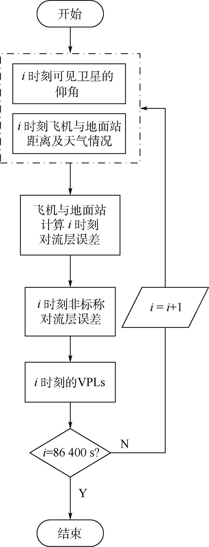
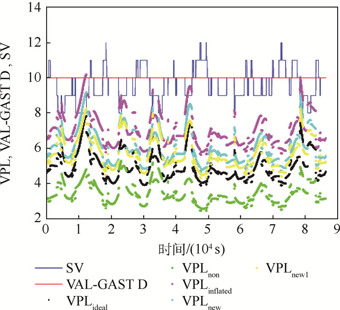
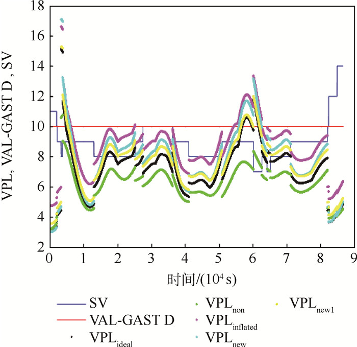
地基增强系统(GBAS)中,非标称对流层误差引起的平均垂直保护级(VPL)增量为2.29 m,误差包络精度降低,系统完好性风险增大。针对上述问题,基于修正的Hopfield模型,综合考虑天气和卫星仰角实时变化情况,以及飞机与地面站的实时距离,提出一种实时计算非标称对流层误差的方法;鉴于该方法对甚高频频数据播发(VDB)传输带宽要求较高,提出拟合计算方法,将实时误差拟合为距离和卫星仰角的函数。仿真计算单点、进近区和终端区3种飞行场景下的VPL,分析非标称对流层误差对GBAS完好性的影响,结果表明:采用实时计算方法时,平均VPL增量为1.55 m,非标称对流层误差的包络精度提高32.52%;采用拟合计算方法时,平均VPL增量为1.27 m,包络精度提高44.54%,VDB传输数据减少,GBAS完好性风险降低。
-
关键词:
- 地基增强系统(GBAS) /
- 完好性 /
- 垂直保护级(VPL) /
- 非标称对流层误差 /
- Hopfield模型
Abstract:In current ground-based augmentation system (GBAS), the average vertical protection level(VPL) increase caused by non-nominal troposphere error is 2.29 m, the accuracy of bounding is reduced and the integrity risk is increased. Faced with the above problems, a real-time method was proposed based on the modified Hopfield model. With real-time method, the non-nominal troposphere error was calculated according to the real-time weather changes, satellite elevation angle and the distance between aircraft and ground station. Given the high requirement of the real-time method for very high frequency data broadcast(VDB) transmission bandwidth, a fitting method was proposed, in which error is a function of distance and elevation angle. Simulations compute the VPL under the flight scenarios of single point, approach area and terminal area with the aim of evaluating the impact of non-nominal troposphere error on GBAS integrity. The results show that, with the real-time bounding method, VPL is averagely increased by 1.55 m and the accuracy of bounding is increased by 32.52%; with fitting method, VPL is averagely increased by 1.27 m, the accuracy of bounding is increased by 44.54%, the VDB transmission data is less, and the GBAS integrity risk is decreased.
-
表 1 垂直告警限
Table 1. Vertical alert limit
垂直告警限 H/m FASVAL H≤60.96 0.095965 H+FASVAL-5.85 60.96 < H≤408.432 FASVAL+33.35 H > 408.432 表 2 传统包络方法下保护级(PL)平均增量
Table 2. Average increase of protection level (PL) with traditional bounding method
星座 进近类型 PL平均增量/m 单点 单次进近 终端区 区域BDS GAST C 1.91 1.67 2.26(VPL) GAST D 1.79 1.73 2.17(LPL) 全球BDS GAST C 2.08 2.50 3.00(VPL) GAST D 1.09 1.72 1.80(LPL) 标准GPS GAST C 2.01 2.47 2.87(VPL) GAST D 1.51 1.86 1.95(LPL) 当前GPS GAST C 2.18 2.43 2.96(VPL) GAST D 2.09 2.52 2.94(LPL) 表 3 实时包络方法下PL平均增量
Table 3. Average increase of PL with real-time bounding method
星座 进近类型 PL平均增量/m 单点 单次进近 终端区 区域BDS GAST C 1.42 1.33 1.63(VPL) GAST D 1.39 1.15 1.27(LPL) 全球BDS GAST C 1.64 1.60 2.04(VPL) GAST D 1.56 1.27 1.48(LPL) 标准GPS GAST C 1.71 1.62 1.99(VPL) GAST D 1.41 1.22 1.29(LPL) 当前GPS GAST C 1.81 1.66 1.96(VPL) GAST D 1.54 1.31 1.32(LPL) 表 4 实时包络方法下包络精度平均提高量
Table 4. Average increase of bounding accuracy with real-time bounding method
星座 进近类型 包络精度平均提高量/% 单点 单次进近 终端区 区域BDS GAST C 16.31 27.92 32.24(VPL) GAST D 28.40 36.90 40.32(LPL) 全球BDS GAST C 12.30 26.42 31.20(VPL) GAST D 34.60 36.39 40.42(LPL) 标准GPS GAST C 18.22 23.12 28.28(VPL) GAST D 35.30 40.80 35.52(LPL) 当前GPS GAST C 27.22 33.34 35.34(VPL) GAST D 40.41 45.31 55.20(LPL) 表 5 拟合包络方法下的PL平均增量
Table 5. Average increase of PL with fitting bounding method
星座 进近类型 PL平均增量/m 单点 单次进近 终端区 区域BDS GAST C 1.03 1.19 1.33(VPL) GAST D 0.85 1.07 1.14(LPL) 全球BDS GAST C 1.20 1.37 1.64(VPL) GAST D 1.07 1.26 1.28(LPL) 标准GPS GAST C 1.32 1.51 1.79(VPL) GAST D 1.01 1.09 1.21(LPL) 当前GPS GAST C 1.36 1.61 1.67(VPL) GAST D 1.01 1.12 1.34(LPL) 表 6 拟合方法下包络精度平均提高量
Table 6. Average increase of bounding accuracy with fitting bounding method
星座 进近类型 包络精度平均提高量/% 单点 单次进近 终端区 区域BDS GAST C 36.51 47.92 52.14(VPL) GAST D 34.40 42.90 47.32(LPL) 全球BDS GAST C 32.30 46.92 51.40(VPL) GAST D 40.60 43.50 46.52(LPL) 标准GPS GAST C 38.22 43.12 48.28(VPL) GAST D 41.30 47.80 42.52(LPL) 当前GPS GAST C 47.62 53.94 55.34(VPL) GAST D 46.80 53.70 60.20(LPL) -
[1] 李康, 巩冠峰.GPS地基增强系统简介及其性能仿真验证[J].电光与控制, 2013, 20(8):89-94. http://www.cnki.com.cn/Article/CJFDTOTAL-DGKQ201308022.htmLI K, GONG G F.Introduction of GPS ground based augmentation system and performance simulation[J].Electronics Optics & Control, 2013, 20(8):89-94(in Chinese). http://www.cnki.com.cn/Article/CJFDTOTAL-DGKQ201308022.htm [2] SUPARTA W.Tropospheric modeling from GPS[M]//SUPARTA W, ALHASA K M.Modeling of tropospheric delays using ANFIS.Berlin:Springer International Publishing, 2016:19-52. [3] DIGGLE D W.An investigation into the use of satellite-based positioning systems for flight reference/autoland operations, dissertation[D].Columbus:Ohio University, 1994:2-17. [4] VAN GRAAS F, KRISHNAN V, SUDDAPALLI R, et al.Conspiring biases in the LAAS[C]//Proceedings of the Annual Meeting-Institute of Navigation.Manassas, VA:ION, 2004:300-307. [5] HUANG J, VAN GRAAS F.Comparison of tropospheric decorrelation errors in the presence of sever weather conditions in different areas and over different baseline lengths[J].Navigation, 2007, 54(3):207-226. doi: 10.1002/navi.2007.54.issue-3 [6] HUANG J, VAN GRAAS F, COHENOUR C.Characterization of tropospheric spatial decorrelation errors over a 5-km baseline[J].Navigation, 2008, 55(1):39-53. doi: 10.1002/navi.2008.55.issue-1 [7] VAN GRAAS F, ZHU Z.Tropospheric delay threats for the GBAS[C]//Proceedings of the International Technical Meeting of the Institute of Navigation.Manassas, VA:ION, 2011:959-964. [8] MATEUS P, NICO G, TOME R, et al.Experimental study on the atmospheric delay based on GPS, SAR interferometry, and numerical weather model data[J].IEEE Transactions on Geoscience & Remote Sensing, 2013, 51(1):6-11. [9] GUILBERT A.Non-nominal troposphere reassessment for meeting CAT Ⅱ/Ⅲ with MC/MF GBAS[C]//Proceedings of the 28th International Technical Meeting of the Satellite Division of the Institute of Navigation.Manassas, VA:ION, 2015:1526-1537. [10] RTCA Inc.Minimum operational performance standards for GPS local area augmentation system airborne equipment:RTCA D0-253C-08[S].Washington, D.C.:RTCA, 2008:52. [11] NILSSON T, BÖHM J, WIJAYA D D, et al.Atmospheric effects in space geodesy[M].Berlin:Springer, 2013:73-136. [12] SKIDMORE T, VAN GRASS F.An investigation of troposphere errors on differential GNSS accuracy and integrity[C]//Proceedings of International Technical Meeting of the Satellite Division of the Institute of Navigation.Manassas, VA:ION, 2004:2752-2760. [13] RIFE J, PULLEN S.The impact of measurement biases on availability for CAT Ⅲ LAAS[J].Navigation, 2006, 52(4):215-228. doi: 10.1002/j.2161-4296.2005.tb00364.x/abstract [14] SEO J, LEE J, PULLEN S, et al.Targeted parameter inflation within GBAS to minimize anomalous ionospheric impact[J].Journal of Aircraft, 2012, 49(2):587-588. doi: 10.2514/1.C031601 [15] 李亮, 赵琳, 丁继成, 等.提高LAAS空间信号可用性的完好性监测新膨胀算法[J].航空学报, 2011, 32(4):664-671. http://www.cnki.com.cn/Article/CJFDTOTAL-HKXB201104011.htmLI L, ZHAO L, DING J C, et al. A new inflation integrity monitoring algorithm for improving availability of LAAS signal-in-space[J].Acta Aeronautica et Astronautica Sinica, 2011, 32(4):664-671(in Chinese). http://www.cnki.com.cn/Article/CJFDTOTAL-HKXB201104011.htm [16] LEE J, PULLEN S, XIE G, et al.LAAS sigma-mean monitor analysis and failure-test verification[C]//Proceedings of Annual Meeting of the Institute of Navigation.Manassas, VA:ION, 2010:694-704. [17] ICAO NSP.GBAS CAT Ⅱ/Ⅲ development baseline SARP:Annex 10, Volume Ⅰ[R].Montreal:International Civil Aviation Organization, 2010. -


 下载:
下载:
