


-
摘要:
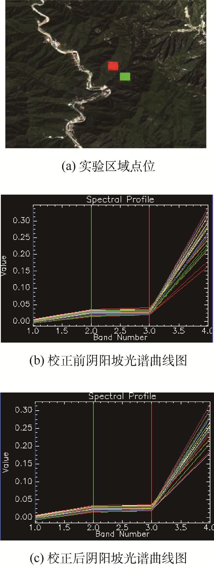
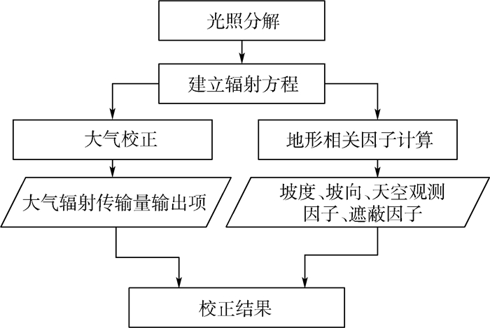
地形辐射校正对获取准确的地表定量遥感精度意义重大。针对传统地形辐射校正模型不适用于高分辨率遥感影像的问题,提出了一种基于辐射传输模型,同时严控误差源的地形辐射校正方法,以资源三号01星高分辨率全色及多光谱遥感影像为例进行相关实验,实现对高分辨率遥感影像的地形辐射校正,并进行了主客观分析与评价。分析结果表明:本文提出的地形辐射校正模型和方法,能有效解决全色遥感影像在绝对辐射定标系数缺失情况下校正效果差以及如何保持高分辨率遥感影像细节等难点,较传统方法更适用于高分辨率遥感影像。
-
关键词:
- 高分辨率遥感影像 /
- 地形辐射校正 /
- 辐射传输 /
- 绝对定标系数 /
- 数字表面模型(DSM)
Abstract:Topographic correction is critical to the accuracy of the earth's surface quantitative remote sensing. Traditional topographic corrective models are not so suitable for high-resolution remote sensing images. In order to address the problem, this paper proposes a topographic correction method based on radiation transfer model and strict control over error sources. High-resolution panchromatic and multispectral images of ZY3-01 satellite were taken as examples to conduct relevant experiments, and the topographic correction of high-resolution remote sensing images was realized with subjective and objective analysis and evaluation. The analysis results show that the problems of poor correction effect without absolute radiometric calibration coefficient in topographic correction of panchromatic remote sensing images can be effectively solved and the detail of high-resolution remote sensing images can also be maintained by the proposed model and method. So it is more suitable for high-resolution remote sensing images than traditional methods.
-
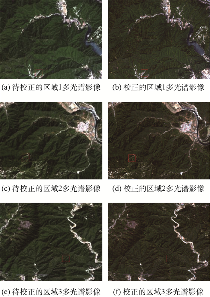
图 4 多光谱遥感影像处理结果辐射对比
Figure 4. Comparison of radiation of multispectral image experimental process results

图 5 多光谱遥感影像处理细节对比
Figure 5. Comparison of process results for details of multispectral images
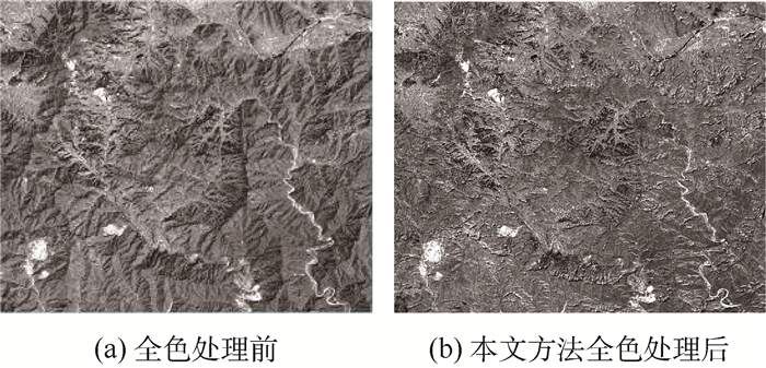
图 6 全色遥感影像处理结果辐射对比
Figure 6. Comparison of radiation of panchromatic image process results
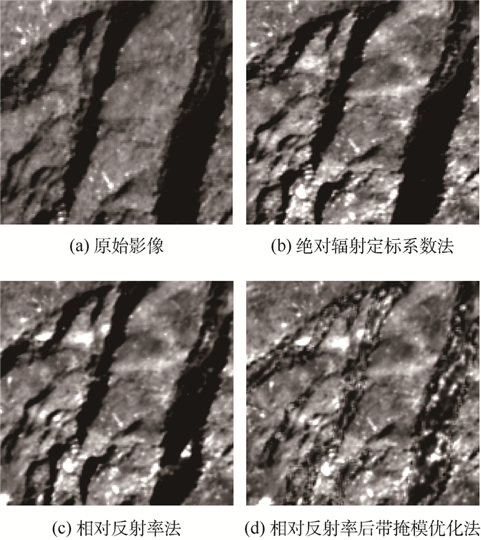
图 7 针对全色遥感影像的不同方法结果对比
Figure 7. Comparison of different methods for panchromatic images

图 8 不同方法的全色遥感影像校正结果对比
Figure 8. Comparison of correction results for panchromatic images among different methods
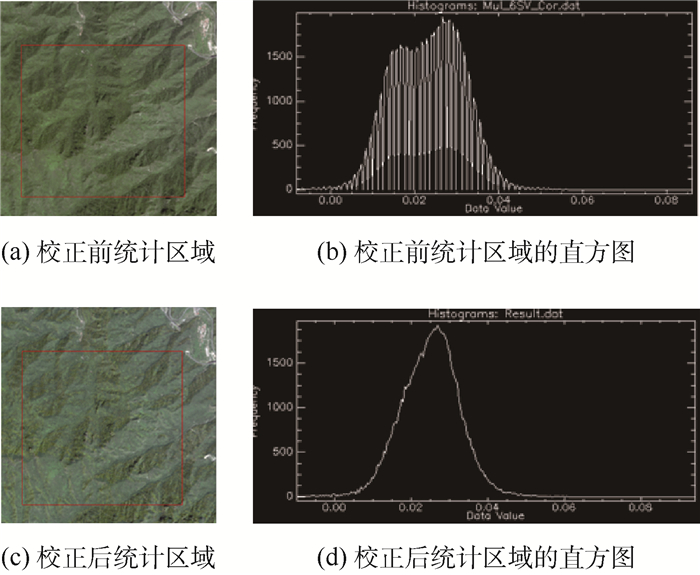
图 10 多光谱遥感影像处理前后直方图统计对比
Figure 10. Statistic comparison of histogram for multispectral image process results

图 11 多光谱遥感影像处理前后X与Y方向剖面对比
Figure 11. Comparison of X and Y direction profiles before and after correction for multispectral image
表 1 资源三号01星遥感影像绝对辐射定标系数
Table 1. Absolute radiometric calibration coefficients for ZY3-01 satellite images
载荷 波段 光谱范围/
μm定标系数增益项 定标系数偏移量 多光谱 Band 1 0.45~0.52 0.233 0 0 Band 2 0.52~0.59 0.216 2 0 Band 3 0.63~0.69 0.178 9 0 Band 4 0.77~0.89 0.194 9 0 全色 Pan 0.50~0.80 0.170 8 0  下载: 导出CSV
表 2 多光谱遥感影像校正前后统计特征值对比
Table 2. Comparison of statistical eigenvalues before and after correction for multispectral images
波段 校正前 校正后 均值/
10-2标准差/
10-2变异系数 均值/
10-2标准差/
10-2变异系数 1 0.407 0.420 1.032 0.505 0.420 0.832 2 2.339 0.832 0.356 2.529 0.757 0.299 3 2.400 0.655 0.273 2.630 0.579 0.220 4 29.049 5.722 0.197 31.469 5.107 0.162
下载: 导出CSV
表 3 全色遥感影像校正前后统计特征值对比
Table 3. Comparison of statistical eigenvalues before and after correction for panchromatic images
统计量 原始图像 C校正法 ATCOR算法 本文方法 均值/10-2 7.59 10.07 8.28 9.55 标准差/10-2 4.36 2.98 2.03 2.10 变异系数 0.574 0.296 0.245 0.220
下载: 导出CSV
-
[1] COLBY J D.Topographic normalization in rugged terrain[J].Photogrammetric Engineering and Remote Sensing, 1991, 57:531-537. [2] 陈志明. 遥感影像地形辐射校正方法研究与系统实现[D]. 福州: 福建师范大学, 2009: 4.CHEN Z M. Research on topographic correction methods for remote sensing image and system implementation[D]. Fuzhou: Fujian Normal University, 2009: 4(in Chinese). [3] 武瑞东.卫星遥感影像数据的地形影响校正[J].遥感信息, 2005(4):31-34.WU R D.Topographic correction of satellite remote sensing image data[J].Remote Sensing Information, 2005(4):31-34(in Chinese). [4] SHEPHERD J D, DYMOND J R.Correcting satellite imagery for the variance of reflectance and illumination with topography[J].International Journal of Remote Sensing, 2003, 24(17):3503-3514. doi: 10.1080/01431160210154029 [5] RICHTER R.Correction of atmospheric and topographic effects for high spatial resolution satellite imagery[J].International Journal of Remote Sensing, 1997, 18(5):1099-1111. doi: 10.1080/014311697218593 [6] 段四波, 阎广建.山区遥感图像地形辐射校正模型研究综述[J].北京师范大学学报(自然科学版), 2007, 43(3):362-366.DUAN S B, YAN G J.A review of models for topographic correction of remotely sensed images in mountainous area[J].Journal of Beijing Normal University(Natural Science), 2007, 43(3):362-366(in Chinese). [7] PROY C, TANRE D, DESCHAMPS P Y.Evaluation of topographic effects in remotely sensed data[J].Remote Sensing of Environment, 1989, 30(1):21-32. doi: 10.1016/0034-4257(89)90044-8 [8] 高永年, 张万昌.遥感影像地形辐射校正研究进展及其比较试验[J].地理研究, 2008, 27(2):467-468.GAO Y N, ZHANG W C.Comparison test and research progress of topographic correction on remotely sensed data[J].Geographical Research, 2008, 27(2):467-468(in Chinese). [9] ZHANG Y, YAN G, BAI Y.Sensitivity of topographic correction to the DEM spatial scale[J].IEEE Geoscience Remote Sensing Letters, 2015, 12(1):53-57. doi: 10.1109/LGRS.2014.2326000 [10] SOLA I, GONZÁLEZ-AUDÍCANA M, ÁLVAREZ-MOZOS J.Validation of a simplified model to generate multispectral synthetic images[J].Remote Sensing, 2015, 7(3):2942-2951. doi: 10.3390/rs70302942 [11] VANONCKELEN S, LHERMITTE S, VAN ROMPAEY A.The effect of atmospheric and topographic correction on pixel-based image composites:Improved forest cover detection in mountain environments[J].International Journal of Applied Earth Observation and Geoinformaiton, 2015, 35B:320-328. [12] 段四波, 阎广建, 穆西晗, 等.基于DEM的山区遥感图像地形辐射校正方法[J].地理与地理信息科学, 2007, 23(6):23-24. doi: 10.3969/j.issn.1672-0504.2007.06.004DUAN S B, YAN G J, MU X H, et al.DEM based remotely sensed imagery topographic correction method in mountainous areas[J].Geography and Geo-Information Science, 2007, 23(6):23-24(in Chinese). doi: 10.3969/j.issn.1672-0504.2007.06.004 [13] SANDMEIER S, ITTEN K I.A physically-based model to correct atmospheric and illumination effects in optical satellite data of rugged terrain[J].IEEE Transactions on Geoscience and Remote Sensing, 1997, 35(3):708-717. doi: 10.1109/36.581991 [14] JIANG B, LIANG S, TOWNSHEND J R, et al.Assessment of the radiometric performance of Chinese HJ-1 satellite CCD instruments[J].IEEE Journal of Selected Topics in Applied Earth Observation & Remote Sensing, 2013, 6(2):840-850. [15] 罗良清, 魏和清.统计学[M].北京:中国财政经济出版社, 2011:49.LUO L Q, WEI H Q.Statistics[M].Beijing:China Financial and Economic Publishing House, 2011:49(in Chinese). -

 下载:
下载:


 点击查看大图
计量
- 文章访问数: 1405
- HTML全文浏览量: 251
- PDF下载量: 549
- 被引次数: 0
