


A building method of high-precision landmark library for landmark autonomous navigation
-
摘要:
利用地标信息的卫星自主导航方法是通过星载光学摄像机实时拍摄地标景象来计算卫星的位置、速度等参数,具有完全自主的特点,并且适用范围广泛,可用于能够周期性获得地面图像的航天器,但受到地标选取方法以及地标库建立策略的制约,影响到导航精度,阻碍了推广使用。针对上述问题,提出了建立全局及高性能的地标库,即采用全球地标控制点选取的原则选取性能优良的全球地标样本,并自动生成全局地标库。通过计算机仿真验证了该方法的有效性,结果表明,使用全球地标控制点选取地标样本,并自动生成全局地标库,可以快速而准确地为航天器进行高精度的自主导航,导航位置误差约为99 m,速度误差约为0.08 m/s。
-
关键词:
- 卫星自主导航 /
- 地标导航 /
- 地标库 /
- 灰度场特征参数 /
- 最大相关系数(MCC)法
Abstract:Satellite autonomous navigation based on landmark information can be used for all kinds of satellites which can periodically obtain images of earth surface for its high accuracy and independence. This method has been restricted by landmark selection method and the establishment strategy of landmark library, which affect the navigation precision and hinder the popularization and application of this navigation method. To solve these problems, a method for establishing global high-performance landmark library is proposed. The global landmark library could be automatically generated by using global landmark control areas to select high-quality global landmark samples. To verify the feasibility of the proposed method, a simulation program was designed. The results show that the position error of the landmark navigation system based on the new landmark library is about 99 m, and velocity error is about 0.08 m/s. The proposed method can provide high-precision autonomous navigation for spacecraft fast and accurately.
-
随着全球贸易的增长,特别是互联网商务的快速发展,全球货运市场日益扩大。相关研究表明,由于货轮运输具有较低的成本,其占有世界远洋集装箱运输99%的市场,仅当对速度有较高要求时才采用运输机运输[1]。浮升混合飞艇兼顾重于空气的飞行器(HTA)和轻于空气的飞行器(LTA)的特点,将飞艇艇体设计成具有高升阻比的外形,同时增加矢量推进系统和气垫着陆系统等,其升力由静浮力和气动升力以及矢量推进系统共同提供,其中静浮力所占比率不大于0.8[2]。由于混合飞艇同时具有中等速度和相对较低的成本,可作为货轮和运输机的折中方案,近年来成为国际远距离货物运输的研究热点[3-4]。
为了产生足够的静浮力满足载重的需求,混合飞艇一般被设计为具有巨大的体积,同时有利于在其较大的表面铺设太阳能电池[5]。但现阶段柔性太阳能电池转换效率较低,无法满足低空混合飞艇长时远距离货物运输的能源需求。锂电池等化学电池的功率密度较高,适合短时间高功率放电,但同时其能量密度较小,也无法满足混合飞艇长时间飞行对于高能量密度电源的需求;与化学电池相比,燃料电池能量密度较高,适合小功率长时间放电,但此类电池功率密度相对较小,不适合高功率短时放电[6]。因此,为了同时满足高功率短时放电和长时高能量密度放电的需求,采用太阳能电池、燃料电池和锂电池等化学电池混合而成的能源系统作为载重运输飞艇的能量来源成为一种较好的选择,可以发挥各种电源的优势,扬长避短。
最早将HTA和LTA的概念互相融合可追溯至20世纪60年代[7],早期关于混合飞艇的研究多集中于可行性的分析,直到2000年英国先进技术集团的SkyCat混合飞艇完成原型机试飞[8]。近年来,结合新型低碳能源的混合飞艇在全球货物运输中的潜在应用逐渐引起国内外学者的重视[9]。Alexander等[1]开发了混合飞艇总体参数设计的程序并论断载重量大于200 t的混合飞艇以70 kn的速度完成货物运输的成本小于15美分/(t·mi)(mi为英里,1 mi=1.609 344 km)。Tensys设计团队开发了用于分析混合飞艇结构力学性能的有限元工具,并与传统飞艇结构力学性能进行了对比分析[10]。国内中航通用飞机有限责任公司和法国飞鲸控股公司于2016年签署合同联合研制载重60 t的混合飞艇[11]。以上国内外的研究通常根据混合飞艇载重运输的任务需求对总体参数进行估值,进而根据关键的特征参数进行迭代求解,虽然可以得到设计参数的可行解,但是无法保证最优。混合飞艇一方面升力同时来源于气动升力和静浮力,另一方面能量同时来源于太阳能电池、燃料电池和化学电池[12],以满足其同时具有长时间定点驻空和远距离快速巡航的性能。因此,在总体设计阶段需要充分考虑气动、结构、推进、能源、控制等多个分系统的耦合协调关系,有必要利用多学科设计优化(Multidisciplinary Design Optimization, MDO)的方法实现对混合飞艇总体参数的优化[13]。
现阶段多种MDO方法已经成功应用在复杂工程系统的设计优化,包括同时分析与设计(SAND)方法、多学科可行(MDF)方法、协同优化(CO)方法和并行子空间优化(CSSO)算法等[14]。其中,Sobieszczanski-Sobieski[15]提出的CSSO算法是分布式两级优化方法,包含一个系统级优化器和多个子空间优化器。相对于MDF方法,CSSO算法有效减小了系统分析的次数,同时能实现子空间的并行优化,优化效率得到一定的提高[16]。最初的CSSO算法中,子空间优化器和系统级优化器的信息协调以及子系统设计的自治性是通过责任系数、平衡系数和相关系数来实现[17]。同时,系统级优化器的设计变量包括所有子系统的设计变量,所需的系统分析次数要比其他分布式MDO方法要多,因此相比之下优化效率依旧较低[18]。Sellar等[19]提出基于响应面的并行子空间优化(CSSO-RS)算法,有效解决了CSSO算法中设计变量无法在子空间之间共享的问题,从而将其扩展到解决非连续型的优化问题,拥有更强的适用性,然而此算法中收敛速率和优化结果依旧受近似模型的选取影响很大[20]。随着研究的深入,近年来出现了越来越多的响应面建模的方法,除了传统的响应面法(RSM)外,还包括多项式回归法、人工神经网络法、Kriging函数法和径向基函数(RBF)法等。选用拟合精度且拟合效率都较高的建模方法,对于其工程应用至关重要[21]。
本文将MDO的设计方法引入到混合飞艇的概念设计中,同时对传统CSSO-RS算法进行改进,以使得系统优化过程中可以根据近似模型的适配性自适应选择更加精确的近似模型,以提高优化结果的精度。混合飞艇分为能源子系统、气动和推进子系统以及结构和重量子系统,在以起飞总重最小作为优化目标的同时,对混合飞艇外形和太阳能电池铺设位置等参数进行优化。
1. 混合飞艇及其任务分析
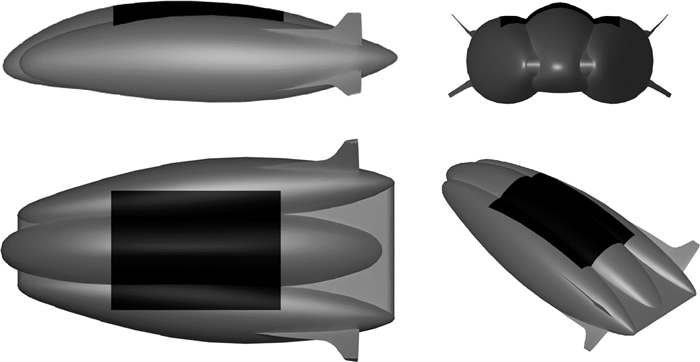
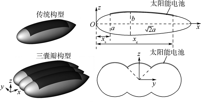
本文采用的混合飞艇总体布局形式如图 1所示,艇身通过三囊瓣组合成具有较高升阻比的气动外形,同时为了提高气动性能,4个分布式尾翼前伸至艇身形成边条状外形,柔性薄膜太阳能电池铺设在艇身顶部,同时艇身两侧分布有4个矢量螺旋桨作为其动力系统。
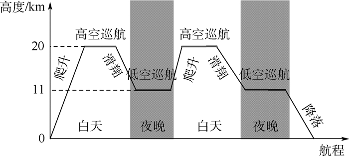
不同的飞行任务要求,如飞行时间、飞行高度、飞行纬度、载荷质量等都会影响混合飞艇的总体参数设计,任务分析是优化问题的前提[14]。由于混合飞艇相比于传统静浮力飞艇具有更高的速度和可操纵性,因此对能源系统提出了更高的要求。然而现阶段柔性薄膜太阳能电池的光电转化效率较低,同时混合飞艇低空飞行过程中所接收到的太阳能有限,难以满足夜间飞行动力系统的需求。因此,本文参考太阳能无人机的重力势能储能技术,白天混合飞艇通过矢量螺旋桨和动升力爬升至20 km高度以充分利用太阳辐射,完成远距离巡航储能;接近日落则关闭动力系统完全利用副气囊控制下降至较低高度,并利用储存能源完成夜间巡航[22],如图 2所示。假设混合飞艇上升和下降过程中,通过副气囊的控制,实现飞艇静浮力保持不变。系统级和子系统级的设计目标是在特定任务中找到一艘总质量最小且满足包括重量平衡和能量平衡在内约束条件的可行飞艇。
 图 2 混合飞艇载重运输任务剖面图Figure 2. Mission profile of hybrid airship for loading transportation
混合飞艇优化问题可归结为

(1) 式中:mtotal为混合飞艇的总质量;mthrust、mstructure、menergy和mpayload分别为推力系统、结构系统、能源系统和载荷系统的质量;B=(ρair-ρHe)gV为混合飞艇静浮力,ρair、ρHe和g分别为空气密度、氦气密度和重力加速度;L=(1/2)ρairv2V2/3CL为混合飞艇气动升力,v、V和CL分别为混合飞艇的飞行速度、体积和气动升力系数;Qreq和Qsup分别为一个昼夜飞行周期内所需的能量和能源系统所能提供的能量。
2. 混合飞艇子系统分析
将混合飞艇分为能源子系统、气动和推进子系统以及结构和重量子系统,不同子系统之间存在较强的耦合关系,因此在设计优化之前需要分别对其进行建模。
2.1 混合飞艇几何外形分析
混合飞艇多囊瓣的升力体外形设计可使得其产生较高的气动升力,这在很大程度上影响结构的重量;同时上表面的复杂曲面也影响太阳能的采集,而执行远距离载重运输的任务过程中需要获取和存储足够的能量,因此几何外形的分析对于其他子系统的建模至关重要。混合飞艇采用如图 1所示的三囊瓣外形设计,其中部截面如图 3所示,为了便于计算,可以将其近似为3个传统旋成体艇身组合而成。通常情况下,传统飞艇艇囊采用双椭圆外形沿x轴旋转360°得到,本文采用的低阻外形方程为

(2) 式中:a和b分别为椭圆的长半轴和短半轴。囊瓣截面半径为r(x)=z,因此参考旋成体飞艇,混合飞艇体积可表示为

(3) 2.2 能源子系统模型
根据任务要求和飞行剖面设计,混合飞艇在白天通过压力调节系统和气动升力上升至20 km高度,充分利用气囊顶部铺设的太阳能电池实现光电能源的转化,夜间降低至11 km高度并利用氢燃料电池和白天储存能源实现有动力巡航飞行。因此,能源子系统包括太阳能电池部分、氢燃料电池(RFC)部分和锂电池部分,输出能源供应推进系统、航电系统和载荷系统,如图 4所示。
混合飞艇上任意太阳能电池接收到的太阳光照度可表示为[23]

(4) 式中:TR和Tg分别为瑞利散射和气体吸收导致的太阳光强度衰减系数; Tw和Ta分别为水蒸气和气溶胶导致的太阳光强度衰减系数; θ为太阳光入射角;I0n为不计大气衰减的法向太阳光照度,可由式(5)得到

(5) 其中:Isc为太阳常数,取值为Isc=1 367 W/m2;E0为地球轨道的偏心修正系数,可精确表示为[24]

(6) 式中:Γ为日期时间角,rad,且有Γ=2π(dn-d0)/365.242 2,dn为日期数,即1月1日时,dn=1,12月31日时,dn=366,d0为日期数修正项,可由式(7)求得[25]

(7) 其中:角度θ为太阳光的入射方向与柔性太阳能电池曲面法线之间的夹角。由于混合飞艇采用三囊瓣的外形设计以满足具有较高气动升力的外形,因此,气囊外表面及所贴附柔性太阳能电池曲率复杂,不同区域位置受太阳光入射角影响较大。如图 5所示,任意倾角为β的微小平面,太阳光入射角θ可表示为[26]

(8)  图 5 任意斜面接收太阳光照示意Figure 5. Position of the sun relative to an arbitrarily oriented plane
式中:ϕ为当地纬度;ω为时间角;γ为平面方位角,表示当地经线与曲面法线方向投影线之间的夹角;δ为太阳赤纬角。

(9) 
(10) 式中:Et为关于时间的方程;tLAT为当地视时。

(11) 另外,tLAT为当地视时,可由当地标准时间tLST求得

(12) 式中:Ls和Le分别为当地所在时区的标准子午线经度和当地的经度。
由于瑞利散射和气体吸收导致的太阳光强度衰减系数TR和Tg可表示为

(13) 式中:mr, air和p分别为理想条件下大气相对光学质量和表面压力。
另外2个引起太阳光强度衰减的因素包括水蒸气和气溶胶,其衰减系数可表示为

(14) 式中:u和m分别为沉积水蒸气量和大气光学质量。
为了便于计算,将混合飞艇顶部柔性太阳能电池沿x和y方向分割为i×j个微小的曲面单元,如图 6所示,选取其中某一微小曲面单元,沿飞行方向上长度为dx,可将其等效为一倾斜的平面,面积Aij可利用曲率半径r表示为

(15) 假设每个囊瓣顶部铺设太阳能电池的角度为θ0,沿飞艇飞行方向铺设长度为l0,总的太阳能电池铺设面积可表示为

(16) 式中:NL=3为囊瓣的个数。因此,太阳能电池总的输出功率可表示为[27]

(17) 式中:Psa, ij为单位面积太阳能电池单元的输出功率,由接收到的太阳光强度Qij和光电转化效率ηij决定,可表示为

(18) 对于非晶硅太阳能电池,光电转化效率ηij与其温度和太阳辐照量有关,可以从式(19)求出[28]

(19) 式中:Q0、T0和λam0在标准测试环境下分别取值为1 000 W/m2、25℃和1.5;Tsa, ij为太阳能电池单元的温度;λam为太阳光穿过大气层时的空气质量比,可由式(20)得到

(20) 式中:FSr为考虑到不同大气成分的修正因子; ph和p0分别为飞行高度和海平面的大气压力; αDIP为在混合飞艇高度的地球视角。
某一微小太阳能电池单元,接收到的太阳光强度Qij主要来源于直接太阳辐射Qsa_dir_ij、散射Qsa_sca_ij和反射Qsa_ref_ij,即可写为Qij=Qsa_dir_ij+Qsa_sca_ij+Qsa_ref_ij。直接太阳辐射Qsa_dir_ij可表示为[29]

(21) 式中:αsa为太阳能电池对于太阳光直接入射辐射的吸收率。太阳能电池所吸收到的太阳光散射Qsa_sca_ij可表示为

(22) 式中:Is为混合飞艇所在高度太阳能电池所接收到的太阳光散射的照度。

(23) 式中:τh为大气透射率;Itop为大气层顶部直接太阳辐射照度。
太阳能电池单元所吸收的地面反射Qsa_ref_ij可表示为

(24) 式中:λ3为太阳能电池单元和地面相对位置系数; ng和nsa分别为地面和太阳能电池的法向量;反射太阳光照度IR可表示为

(25) 其中:ratm在晴朗无云天气下取值为0.18,在多云天气下取值为0.57[30]。
太阳能电池单元的热平衡方程可表示为[31]

(26) 式中:msa, ij和csa分别为太阳能电池单元的质量和比热容;Qsa_IR_ex, ij、Qsa_conv_ex, ij和Qsa_cond, ij分别为太阳能电池单元红外辐射、对流传热和热传导的热量。
考虑到太阳能电池安装设备将导致其质量增大30%,因此太阳能电池质量可表示为[32]

(27) 式中:ρsa为太阳能电池的面密度。
夜间巡航过程能量由燃料电池储能系统提供,系统质量由夜间续航时间所决定,由式(28)可得

(28) 式中:EESS为燃料电池的能量总量;ρESS为能量密度;Tnight为夜间巡航时间; ηESS为放电效率;Preq为需求功率,可表示为

(29) 其中:ηprop为推进系统效率;Pothers为其余部件所需的功率;CD为气动阻力系数。
锂电池仅用于爬升过程能量的供给,由于最大爬升速度为[12, 33]

(30) 式中:ζ为飞行轨迹倾角; CD0为零升阻力系数; Pava为可获取的能量;K为升致阻力系数。由于混合飞艇从11 km高度爬升至20 km高度,可进一步求出Pava,假设锂电池能量密度为ω=200 W·h/kg,则锂电池质量可表示为

(31) 式中:tclim为爬升时间。
能源系统总质量可表示为

(32) 2.3 气动和推进子系统模型
混合飞艇不同于传统的旋成体静浮力飞艇,为了提高其气动性能,艇身通常由2~4个囊瓣组成,其升力和阻力特性尚无准确的经验公式可供参考。Carrión等[34]利用计算流体力学(CFD)方法研究了混合飞艇的气动性能,并通过将三囊瓣构型混合飞艇等效为传统旋成体静浮力飞艇,并将CFD计算结果与利用传统旋成体飞艇气动性能估算公式所得结果进行对比,验证了工程估算阶段近似等效的可靠性。对于常规旋成体飞艇,艇体体积阻力系数可按照Hoerner公式进行估算[35]。

(33) 式中:FR为长细比;CF为表面摩擦系数,当雷诺数Re在[106, 108]范围内可由Schoernerr公式得到[36]

(34) 由于混合飞艇外形由三囊瓣组合而成,式中FR=l/d不易直接给出,可对其进行等效。假设存在与宽度为w的三囊瓣构型混合飞艇截面面积相等的传统旋成体飞艇,其截面直径为de,几何尺寸如图 7所示。作为决定气动性能的重要因素,参考固定翼飞机定义混合飞艇展弦比为

(35)  图 7 混合飞艇等效传统旋成体飞艇示意Figure 7. Equivalent of hybrid airship and conventional rotated airship
式中:splan=πlBw/4为混合飞艇艇囊俯视平面面积,lB为等效旋成体纵截面长轴长度。则式(35)可化为

(36) 进一步根据等效旋成体飞艇参数,定义混合飞艇的长细比为

(37) 由于传统旋成体飞艇为椭球体,等效过程保持飞艇体积不变,则可求出等效旋成体飞艇截面直径为

(38) 由于矢量桨和尾翼等附加物所引起的摩擦阻力和干扰阻力,混合飞艇总体积阻力系数要比单独艇身的阻力系数略大,可表示为

(39) 式中:N为阻力放大系数,混合飞艇低空巡航过程中取值为N=2.3±0.7,而高空巡航过程中可取值为N=2[37]。由于升力系数与阻力系数之间的关系可表示为[12]

(40) 因此,可进一步求出混合飞艇气动升力系数,混合飞艇总阻力和气动升力可分别表示为

(41) 
(42) 推进系统质量由推进系统最大功率决定,与最大飞行速度vmax、阻力系数CD和参考面积V2/3有关,另外考虑到减速装置将导致系统质量增大30%,因此推进系统质量为[14]

(43) 式中:SPprop为电机和螺旋桨的功率质量比。
2.4 结构和重量子系统模型
常规静浮力飞艇通常分为硬式、软式和半硬式3种结构形式,而洛克希德·马丁公司经过长期的论证分析,指出只有通过“超压维形”的非刚性结构的混合飞艇,才具有设计的可行性[2]。此时混合飞艇构型与结构设计的重点在于浮力率BR、艇体展弦比AR和长细比FR三者之间的协调关系。
混合飞艇结构重量很大程度上由艇身表面积决定,通过线性拟合可得到相同体积条件下的三囊瓣混合飞艇长细比FR和表面积Shull之间的关系,进一步得到艇囊结构重量为

(44) 式中:κ为由于加工过程中气囊缝合焊接等工艺造成的艇体质量增加系数,本文取κ=1.2;ρenv为气囊材料面密度。
由于混合飞艇体积巨大,其尾翼通常采用艇体材料加内部维形结构通过充气实现,内部结构使得尾翼结构质量增加20%,同时尾翼表面积与艇体体积比通常可取Sfin/V=0.012 1 m2/m3,则尾翼的质量可表示为

(45) 因此,系统结构质量可表示为

(46) 3. 混合飞艇设计优化框架及系统分析
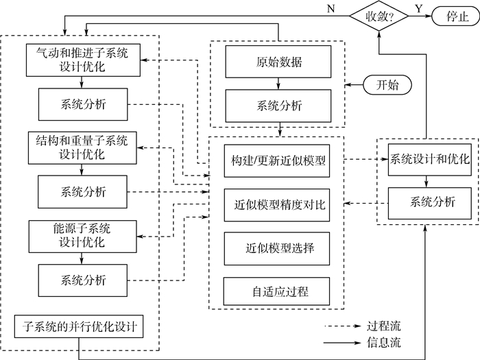
3.1 混合飞艇设计优化框架
将混合飞艇分为气动子系统、结构子系统、能源子系统和推进子系统,并通过自适应近似模型的选取分析各子系统之间的耦合关系,进一步实现系统级优化。利用自适应CSSO-RS算法实现混合飞艇总体参数多学科设计优化的框架如图 8所示。与传统的CSSO-RS算法不同之处在于近似模型的建立,为了优化模型适配性并提高精度,本文同时构建RSM和RBF近似模型,进一步通过变量相对误差均值e和标准差σe判断近似模型的优劣,并选取各阶段精度更好的近似模型。变量相对误差均值e和标准差σe的定义为

(47) 式中:yi和

自适应CSSO-RS算法初始样本点和测试点通过均匀试验设计得到,同时计算得到相对应的状态变量,以获取数据库。通过RSM和RBF近似模型的自适应判断,选用适配性更好的模型用于系统级优化。通过将系统级优化中的最优设计变量设置为下一个迭代过程的初始设计变量,可以保证获取适应性更强的设计变量。优化问题中能源子系统、气动和推进子系统、结构和重量子系统的优化可分别归结为式(48)~式(50),方程中带有“∧”符号的状态变量表示来源于近似模型,而不带有“∧”符号的状态变量则来源于子系统分析。整个系统最终的优化问题可归结为式(51),其中所有的状态变量均来自于近似模型。

(48) 
(49) 
(50) 
(51) 混合飞艇初始输入参数如表 1所示,飞行时间在夏至日,飞行纬度在30°N。
表 1 混合飞艇优化初始参数Table 1. Initial parameters of hybrid airship optimization初始参数 数值 巡航速度v/(m·s-1) 20 囊体材料面密度ρenv/(kg·m-2) 0.2 太阳能电池面密度ρsa/(kg·m-2) 0.3 载荷重量mpayload/kg 1 000 燃料电池能量密度ρESS/(Wh·kg-1) 1 000 电机和螺旋桨功率质量比SPprop/(W·kg-1) 440 推进系统效率ηprop 0.72 燃料电池放电效率ηESS 0.55 3.2 混合飞艇系统分析
对混合飞艇进行系统分析,可用来描述系统性能,并进一步为近似模型的自适应选取提供参考。本文将混合飞艇分为能源子系统、气动和推进子系统以及结构和重量子系统,所有必要的信息均可分布计算获取,如图 9所示。
4. 混合飞艇优化结果及分析
首先利用试验设计方法(Design of Experiment, DOE)构造数据样本点,为了获取分布更加均匀的样本点,采用均匀试验设计获取系统级优化所需的初始样本。优化过程重量平衡和能量平衡迭代收敛情况如图 10所示,可知,重量平衡和能量平衡均能较好地满足设计要求,同时本文所采用的自适应CSSO-RS算法有效减小了重量平衡和能量平衡的收敛迭代次数,其计算量较小,具有较好的实用性。
 图 10 设计优化迭代收敛过程对比Figure 10. Comparison of design optimization iterativeconvergence process
为了更加清晰地显示出自适应算法在优化收敛过程中近似模型的选择过程,将变量相对误差均值e和标准差σe提取并绘制曲线如图 11和图 12所示。由图 11可知,对于重量平衡的优化,整个迭代过程中采用RSM近似模型的e和σe数值均小于RBF模型,即RSM近似模型的精确度和集中程度始终优于RBF近似模型。由图 12所示,对于能量平衡的优化,随着迭代次数的增加,采用RSM近似模型的e和σe的数值逐渐大于RBF近似模型,即RBF近似模型性能逐渐优于RSM近似模型。分析原因可知,重量平衡中精确的计算模型为二阶非线性模型,针对此模型RSM近似模型具有较为明显的优势;而能量平衡中所采用的精确的计算模型与气动阻力有关,属于高阶的非线性数学模型,此时近似模型的精确度受样本量的影响较大。因此,所采用的自适应CSSO-RS算法根据变量相对误差均值e和标准差σe判断近似模型的优劣,并选取各阶段精度更好的近似模型。不同变量的优化结果如表 2所示,可知,采用自适应CSSO-RS算法优化所得结果在保证载荷重量不变的前提下,使得起飞总重和能量需求均有明显降低,取得较好的优化效果。
 图 11 迭代收敛过程重量平衡对于近似模型的选择Figure 11. Selection of approximate model for weight balance in iterative convergence process
 图 12 迭代收敛过程能量平衡对于近似模型的选择Figure 12. Selection of approximate model for energy balance in iterative convergence process表 2 优化结果对比Table 2. Comparison of optimization results
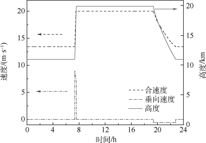
参数 数值 传统CSSO-RS算法 自适应CSSO-RS算法 等效飞艇长半轴a/m 51.23 48.75 太阳能电池起点位置坐标xs/m 22.35 18.11 混合飞艇体积V/m3 129 797.74 128 009.89 混合飞艇总质量mtotal/kg 22 551.23 21 698.86 燃料电池质量mESS/kg 4 948.79 4 019.28 太阳能电池质量msa/kg 1 487.81 1 554.63 锂电池质量mLi/kg 2 537.72 3 019.44 能量供给Qsup/kWh 4 968.84 4 642.65 等效飞艇短半轴b/m 19.5 19.5 太阳能电池结束位置坐标xe/m 96.32 94.68 太阳能电池面积Asa/m2 3 796.47 3 986.23 能源子系统重量menergy/kg 8 974.32 8 592.95 结构子系统重量mstructure/kg 10 379.59 10 076.42 推进子系统重量mthrust/kg 2 197.32 2 029.49 载荷子系统重量mpayload/kg 1 000 1 000 能量需求Qreq/kWh 4 968.83 4 642.64 对优化后混合飞艇飞行任务剖面进行分析,其速度和飞行高度变化曲线如图 13所示。由图可知,混合飞艇在日出时快速爬升至20 km高空,最大爬升速度可达到约9 m/s,爬升角度远大于固定翼飞机的爬升角度,这是在副气囊调节静浮力保持不变的条件下,通过矢量螺旋桨的控制和气动升力的共同实现。而日落后关闭动力系统,仅依靠副气囊调节,实现混合飞艇的缓慢降落,同时有效节省动力系统能源。
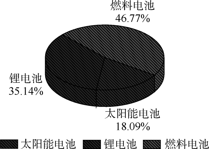
另外,图 14列出了最终优化结果所得的各子系统重量分配情况分析。可知,能源子系统和结构子系统的重量占混合飞艇总重的绝大部分,分别占比39.6%和46.44%,这与实际情况较为符合,通过更加合理的结构设计降低结构自身重量依旧是混合飞艇设计的重要措施。图 15显示了能源子系统中各部分重量比重,其中燃料电池的重量占比较大,达到46.77%,锂电池次之,薄膜太阳能电池重量占比最小,因此储氢技术等关键技术的发展对于其应用于混合飞艇的设计至关重要。
 图 15 混合飞艇能源子系统重量分配Figure 15. Weight distribution among energy subsystem of hybrid airship
5. 结束语
针对升力体式浮升混合飞艇分系统耦合关系复杂的特点,将多学科设计优化方法引入到混合飞艇的总体设计中,进一步将其分解为能源子系统、气动和推进子系统以及结构和重量子系统。通过构建各个分系统的模型,提出具有自适应能力的基于响应面的并行子空间优化算法,将重量平衡和能量平衡作为实现远距离载重运输的约束条件,并提出爬升、日间巡航、滑翔和夜间巡航的多阶段任务剖面,以充分利用太阳能电池、燃料电池和锂电池的优势,实现混合飞艇的最优化设计。优化结果表明,具有自适应能力的优化算法在精确度和计算效率上均有明显的优势,同时重量分配的结果也为混合飞艇结构轻量化设计和能源系统设计提出了更高的要求。
-
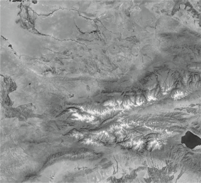
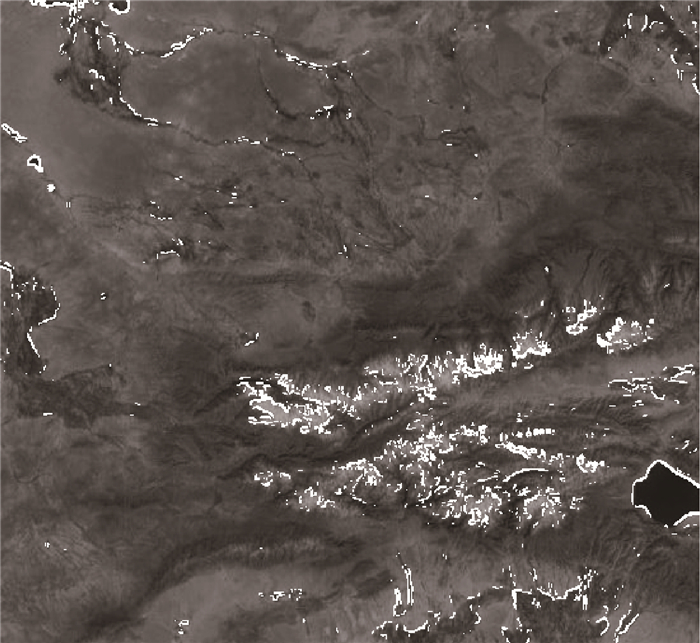
图 4 混合地貌遥感图像的灰度化结果
Figure 4. Grayscale results of remote sensing image of mixed landscape

图 14 使用本文地标库进行导航的导航误差
Figure 14. Navigation error of navigation with landmark library in the text

图 15 不同地标信息数量的位置RMSE对比
Figure 15. Comparison of position RMSE for different number of landmark information
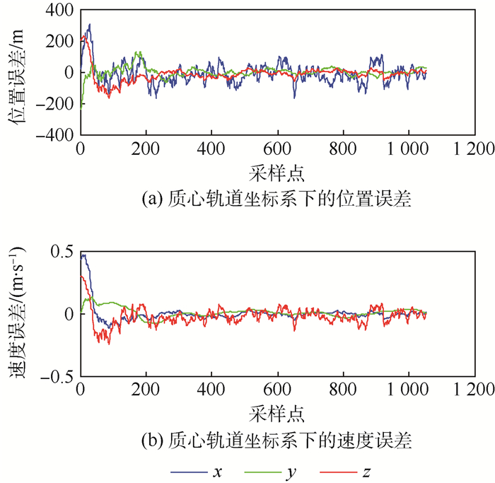
图 16 使用传统地标库进行导航的导航误差
Figure 16. Navigation error of navigation with traditional landmark library
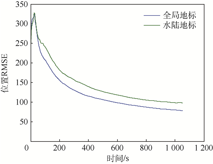
图 17 不同地标库的位置RMSE对比
Figure 17. Comparison of position RMSE for different landmark libraries
表 1 样例轨道的轨道要素
Table 1. Orbital elements of sample orbit
参数 a/m e i/(°) ω/(°) M0/(°) 数值 7 478 137.0 0 45.0 0 0  下载: 导出CSV
表 2 不同轨道高度仿真结果对比
Table 2. Comparison of simulation results of different orbital heights
轨道高度/
km平均位置误差
(3σ)/m平均速度误差
(3σ)/(m·s-1)500 62.713 4 0.058 2 800 87.832 8 0.080 3 1 100 99.125 5 0.086 9 1 400 123.505 0 0.109 4 1 700 165.607 7 0.130 0 2 000 192.363 7 0.141 5
下载: 导出CSV
表 3 不同地标信息数量仿真结果对比
Table 3. Comparison of simulation results of different number of landmarks information
地标信息数量 平均位置误差
(3σ)/m平均速度误差
(3σ)/(m·s-1)2 99.917 7 0.088 2 3 99.125 5 0.086 9 4 98.898 4 0.085 2
下载: 导出CSV
-
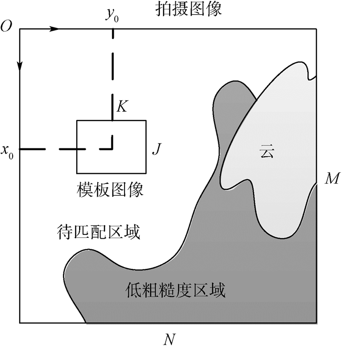
[1] KAU S P. Autonomous satellite orbital navigation using known and unknown earth landmarks[C]//Guidance and Control Conference. Reston: AIAA, 1975: 1-12. [2] BACHMANN M, BENDIX J.An improved algorithm for NOAA-AVHRR image referencing[J].International Journal of Remote Sensing, 1992, 13(16):3205-3215. doi: 10.1080/01431169208904111 [3] HO D, ASEM A.NOAA AVHRR image referencing[J].International Journal of Remote Sensing, 1986, 7(6):895-904. [4] ILLERA P, DELGADO J A, CALLE A.A navigation algorithm for satellite images[J].International Journal of Remote Sensing, 1996, 17(3):577-588. doi: 10.1080/01431169608949028 [5] MOIGNE J L, CAMPBELL W J, CROMP R F, et al.An automated parallel image registration technique based on the correlation of wavelet features[J].IEEE Transactions on Geoscience and Remote Sensing, 2002, 40(8):1849-1864. doi: 10.1109/TGRS.2002.802501 [6] TOWNSHEND J R, JUSTICE C O, GURNEY C E, et al.The impact of misregistration on change detection[J].IEEE Transactions on Geoscience and Remote Sensing, 1992, 30(5):1054-1060. doi: 10.1109/36.175340 [7] DAI X, KHORRAM S.The effects of image misregistration on the accuracy of remotely sensed change detection[J].IEEE Transactions on Geoscience and Remote Sensing, 1998, 36(5):1566-1577. doi: 10.1109/36.718860 [8] 杨磊, 杨忠东.极轨气象卫星自动地标导航方法[J].应用气象学报, 2009, 20(3):329-336.YANG L, YANG Z D.The automated landmark navigation of the polar meteorological satellite[J].Journal of Applied Meteorological Science, 2009, 20(3):329-336(in Chinese). [9] EMERY W J, BALDWIN D, MATTHEWS D.Maximum cross correlation automatic satellite image navigation and attitude corrections for open-ocean image navigation[J].IEEE Transactions on Geoscience and Remote Sensing, 2003, 41(1):33-42. doi: 10.1109/TGRS.2002.808061 [10] 郭强, 杨磊, 赵现纲, 等.气象卫星图像导航的地标匹配算法研究与优化[J].计算机工程与应用, 2013, 49(24):152-156. doi: 10.3778/j.issn.1002-8331.1305-0212GUO Q, YANG L, ZHAO X G, et al.Research and optimization of landmark matching algorithm for meteorological satellite image navigation[J].Computer Engineering and Applications, 2013, 49(24):152-156(in Chinese). doi: 10.3778/j.issn.1002-8331.1305-0212 [11] KIM T, LEE T, CHOI H.Landmark extraction, matching and processing for automated image navigation of geostationary weather satellites[J].Proceedings of SPIE, 2005, 5657(1):30-37. doi: 10.1117/12.578651.full [12] 卢耀秋.静止气象卫星的地标导航计算方法[J].计算物理, 1992, 9(4):775-777.LU Y Q.Landmark navigation method of geostationary meteorological satellite[J].Chinese Journal of Computational Physics, 1992, 9(4):775-777(in Chinese). [13] 赵礼铮, 白光弼.极轨气象卫星局部数据集的精地标导航[J].气象, 1992, 18(11):44-46.ZHAO L Z, BAI G B.Navigation of precise landmarks in polar-orbit meteorological satellite local data[J].Meteorological Monthly, 1992, 18(11):44-46(in Chinese). [14] 杨磊, 冯小虎, 郭强, 等.风云二号气象卫星图像自动几何精校正[J].计算机工程与应用, 2011, 47(3):202-206.YANG L, FENG X H, GUO Q, et al.Automatic geometric precision correction of Fengyun-2 meteorological satellite imagery[J].Computer Engineering and Applications, 2011, 47(3):202-206(in Chinese). [15] ROSBOROUGH G W, BALDWIN D G, EMERY W J, et al.Precise AVHRR image navigation[J].IEEE Transactions on Geoscience and Remote Sensing, 1994, 32(3):644-657. doi: 10.1109/36.297982 [16] 蒋春华.浅析纹理防伪技术[J].中国防伪报道, 2012(11):47-50.JIANG C H.Analysis of texture anti-counterfeiting technology[J].China Anti-Counterfeiting Report, 2012(11):47-50(in Chinese). [17] 郑彤, 蔡龙飞, 王志刚, 等.地形匹配辅助导航中匹配区域的选择[J].中国惯性技术学报, 2009, 17(2):191-196.ZHENG T, CAI L F, WANG Z G, et al.Selection of matching area in terrain match aided navigation[J].Journal of Chinese Inertial Technology, 2009, 17(2):191-196(in Chinese). 期刊类型引用(3)
1. 张华,黄龙太,张航,杨旭东. 浮升一体化飞艇布局及设计参数敏感性. 科学技术与工程. 2025(05): 2161-2167 .  百度学术
百度学术2. 刘思宇,高健,孙康文. 太阳能飞艇刚性电池阵列接收能量分析. 北京航空航天大学学报. 2024(11): 3542-3552 .  本站查看
本站查看3. 单春来,刘朋科,古斌,贺琦,徐宏英. 多级优化算法在火炮总体结构设计中的应用. 兵工学报. 2022(01): 11-19 . 百度学术其他类型引用(5)
-

 下载:
下载:


 下载:
下载:


 百度学术
百度学术
 点击查看大图

计量
- 文章访问数: 967
- HTML全文浏览量: 175
- PDF下载量: 523
- 被引次数: 8
