


-
摘要:
星载GNSS反射信号建模与仿真对GNSS反射信号正逆问题的研究及接收机算法和性能的评估非常重要。从几何、信号和信息的角度建立了星载GNSS反射信号分层建模方法。详细论述了星载GNSS反射信号的双基几何关系,建立了海风、涌浪和降雨驱动的线性组合海浪谱,并基于此计算了GNSS反射信号双基散射系数,基于各散射单元独立散射的假设推导了反射信号模型,通过仿真产生了星载GNSS反射信号及时延-多普勒相关功率,并与UK TDS-1卫星实测相关功率进行了对比分析。结果显示,通过先产生反射信号后处理得到的相关功率和直接端对端产生的相关功率与UK TDS-1卫星实测的相关功率的余弦相似度分别为0.97和0.94,所提架构和方法可正确对星载GNSS反射信号进行建模和仿真。同时,通过所建平台分析了涌浪和降雨形成的海浪谱对星载GNSS反射信号的影响。结果发现,涌浪主要影响低风速探测而对高风速无影响,降雨对星载GNSS反射信号无明显影响。
-
关键词:
- 星载GNSS反射信号 /
- 双基几何关系 /
- 双基散射 /
- 建模与仿真 /
- 时延-多普勒图
Abstract:The modeling and simulation of spaceborne GNSS reflectometry is important for the research of forward and inverse problem of GNSS reflectometry, and the evaluation of algorithm and performance in the receiver. This paper firstly develops the layered structure of modeling spaceborne GNSS reflectometry from the perspectives of geometry, signals and related power. Secondly, the bistatic geometry of spaceborne GNSS reflectometry is discussed in detail. Thirdly, the sea spectrum is developed by linearly combining wind-, swell- and rain-driven sea spectrum, and further bistatic scattering coefficient is computed. Fourthly, based on the assumption that scattered signals from each scattering unit are independent, an ocean-reflected GNSS signal model is derived. Finally, the ocean-reflected GNSS signals and delay-Doppler maps are produced by simulation, and are analytically compared to the measured correlation power from UK TDS-1. The results show the simulated delay-Doppler maps obtained through end-to-end simulating correlation power and through processing simulated GNSS signal have the cosine similarity of 0.97 and 0.94 with the measured delay-Doppler maps from UK TDS-1 respectively, so that proposed approach could be used to simulate correctly reflected GNSS signals and delay-Doppler maps through comparing the simulated delay-Doppler maps and actual ones received from UK TDS-1. In addition, the simulation analysis of the influence of swell and rain on the reflected GNSS signals shows that swell mainly impacts reflected GNSS signal for low wind speed and does not impact it for high wind speed, and rain has no significant influence on the reflected GNSS signal.
-

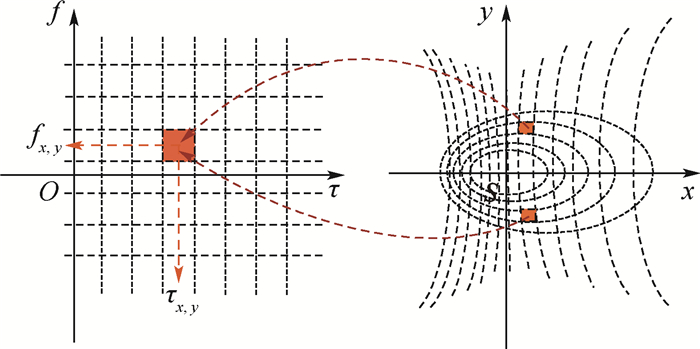
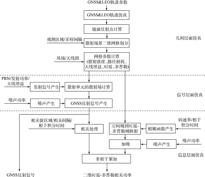
图 1 星载GNSS反射信号建模总体架构
Figure 1. Architecture of modeling for spaceborne GNSS reflectometry

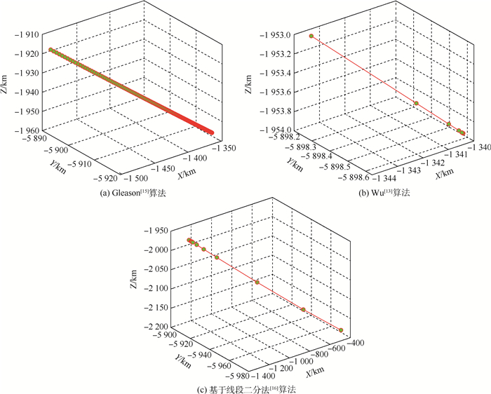
图 4 GNSS反射信号的镜面反射点迭代收敛过程
Figure 4. Iterative convergence procedure of computing specular point of GNSS reflectometry

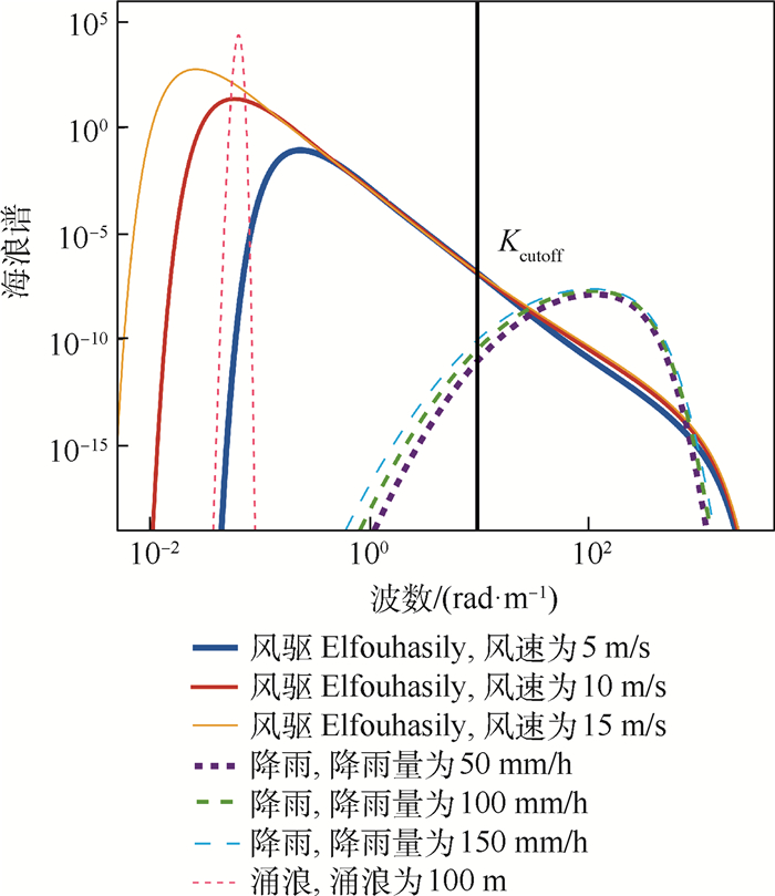
图 6 风驱Elfouhasily、降雨及涌浪驱动的海浪谱
Figure 6. Wind-driven Elfouhasily, rain-driven and swell-driven sea spectrum

图 7 海面散射系数随GNSS信号入射角的变化
Figure 7. Sea surface scattering coefficient changing with incidence angle of GNSS signals

图 8 海面散射系数随海面风速和风向的变化
Figure 8. Sea surface scattering coefficient changing with sea wind speed and direction

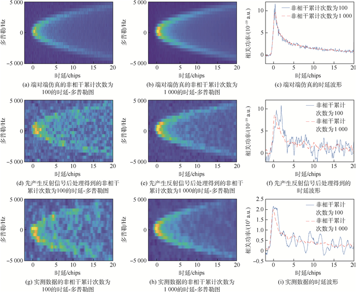
图 9 UK TDS-1实测数据的相关功率的分布
Figure 9. Correlation power distribution of actual data from UK TDS-1

图 10 星载GNSS-R反射信号仿真和实测的相关功率分布
Figure 10. Simulated and actual correlation power distribution of spaceborne GNSS reflectometry

图 11 涌浪对GNSS反射信号相关功率的影响
Figure 11. Influence of swell on correlation power of GNSS reflectometry
表 1 星载GNSS反射信号仿真场景
Table 1. Simulation scenario of spaceborne GNSS reflectometry
参数 数值 TECFE/m (-13 007 569.860 925,-8 505 257.898 300,21 510 082.301 892) RECFE/m (-3 891 459.881 292,-2 384 206.424 071,5 311 648.834 032) vECEF, t/(m·s-1) (1 656.448 651,-2 184.040 116,192.192 840) vECEF, r/(m·s-1) (-5 724.252 580,921.295 986,4 141.815 284) 风速/(m·s-1) 5 天线增益/dB 12 波束宽度/(°) 38 涌浪/m 0 降雨/(mm·h-1) 0  下载: 导出CSV
-
[1] LI W, CARDELLACH E, FABRA F, et al. Assessment of spaceborne GNSS-R ocean altimetry performance using CYGNSS mission raw data[J]. IEEE Transactions on Geoscience and Remote Sensing, 2020, 58(1): 238-250. doi: 10.1109/TGRS.2019.2936108 [2] RODRIGUEZ-ALVAREZ N, AKOS D M, ZAVOROTNY V U, et al. Airborne GNSS-R wind retrievals using delay-Doppler maps[J]. IEEE Transactions on Geoscience and Remote Sensing, 2013, 51(1): 626-641. doi: 10.1109/TGRS.2012.2196437 [3] YAN Q, HUANG W. Sea ice remote sensing using GNSS-R: A review[J]. Remote Sensing, 2019, 11(21): 2565. doi: 10.3390/rs11212565 [4] WU X, DONG Z, JIN S, et al. First measurement of soil freeze/thaw cycles in the tibetan plateau using CYGNSS GNSS-R data[J]. Remote Sensing, 2020, 12(15): 2361. doi: 10.3390/rs12152361 [5] FOTI G, GOMMENGINGER C, JALES P, et al. Spaceborne GNSS reflectometry for ocean winds: First results from the UK TechDemoSat-1 mission[J]. Geophysical Research Letters, 2015, 42(13): 5435-5441. doi: 10.1002/2015GL064204 [6] RUF C S, ATLAS R, CHANG P S, et al. New ocean winds satellite mission to probe hurricanes and tropical convection[J]. Bulletin of the American Meteorological Society, 2016, 97(3): 385-395. doi: 10.1175/BAMS-D-14-00218.1 [7] JING C, NIU X, DUAN C, et al. Sea surface wind speed retrieval from the first Chinese GNSS-R mission: Technique and preliminary results[J]. Remote Sensing, 2019, 11(24): 3013. doi: 10.3390/rs11243013 [8] PARK H, CAMPS A, VALENCIA E, et al. Retracking considerations in spaceborne GNSS-raltimetry[J]. GPS Solutions, 2012, 16(4): 507-518. doi: 10.1007/s10291-011-0251-7 [9] PARK H, MARCHAN-HERNANDEZ J F, RODRIGUEZ-ALVAREZ N, et al. End-to-end simulator for global navigation satellite system reflectometry space mission[C]//2010 IEEE International Geoscience and Remote Sensing Symposium. Piscataway: IEEE Press, 2010: 4294-4297. [10] HOOVER K E, MECIKALSKI J R, LANG T J, et al. Use of an end-to-end-simulator to analyze CYGNSS[J]. Journal of Atmospheric and Oceanic Technology, 2018, 35(1): 35-55. doi: 10.1175/JTECH-D-17-0036.1 [11] BAI W, XIA J, ZHAO D, et al. GREEPS: An GNSS-R end-to-end performance simulator[C]//2016 IEEE International Geoscience and Remote Sensing Symposium. Piscataway: IEEE Press, 2016: 16444628. [12] ZAVOROTNY V U, VORONOVICH A G. Scattering of GPS signals from the ocean with wind remote sensing application[J]. IEEE Transactions on Geoscience and Remote Sensing, 2000, 38(2): 951-964. doi: 10.1109/36.841977 [13] WU S C, MEEHAN T, YOUNG L. The potential use of GPS signals as ocean altimetry observable[C]//Proceedings of the National Technical Meeting of the Institute of Navigation, 1997. [14] WAGNER C, KLOKOCNIK J. The value of ocean reflections of GPS signals to enhance satellite altimetry: Data distribution and error analysis[J]. Journal of Geodesy, 2003, 77(3-4): 128-138. doi: 10.1007/s00190-002-0307-0 [15] GLEASON S, GEBRE-EGZIABHER D. GNSS应用与方法[M]. 杨东凯, 樊江滨, 译. 北京: 电子工业出版社, 2011.GLEASON S, GEBRE-EGZIABHER D. GNSS application and method[M]. YANG D K, FAN J B, translated. Beijing: Electronics Industry Publishing House, 2011(in Chinese). [16] 张波, 王峰, 杨东凯. 基于线段二分法的GNSS-R镜面反射点估计算法[J]. 全球定位系统, 2013, 38(5): 11-16. doi: 10.3969/j.issn.1008-9268.2013.05.003ZHANG B, WANG F, YANG D K. The algorithm for the determination of the GNSS-R specular point based on the dichotomy of the line segment[J]. GNSS World of China, 2013, 38(5): 11-16(in Chinese). doi: 10.3969/j.issn.1008-9268.2013.05.003 [17] VORONOVICH A G, ZAVOROTNY V U. Bistatic radar equation for signals of opportunity revisited[J]. IEEE Transactions on Geoscience and Remote Sensing, 2018, 56(4): 1959-1968. doi: 10.1109/TGRS.2017.2771253 [18] LEADER J C. Incoherent backscatter from rough surfaces: The two-scale model reexamined[J]. Radio Science, 1978, 13(3): 441-457. doi: 10.1029/RS013i003p00441 [19] ROBERTSON J S. Wave scattering from rough surfaces[M]. Berlin: Springer, 1999: 217-274. [20] BRONWN G S. Backscattering from a Gaussian-distributed perfectly conducting rough surface[J]. IEEE Transactions on Antennas and Propagation, 1978, 26(3): 472-482. doi: 10.1109/TAP.1978.1141854 [21] ELFOUHAILY T, CHAPRON B, KATSAROS K, et al. A unified directional spectrum for long and short wind-driven waves[J]. Journal of Geophysical Research Oceans, 1997, 102(C7): 15781-15796. doi: 10.1029/97JC00467 [22] BLIVEN L F, SOBIESKI P W, CRAEYE C. Rain generated ring-waves: Measurements and modelling for remote sensing[J]. International Journal of Remote Sensing, 1997, 18(1): 221-228. doi: 10.1080/014311697219385 [23] DURDEN S L, VESECKY J F. A physical radar cross-section model for a wind-driven sea with swell[J]. IEEE Journal of Oceanic Engineering, 1985, 10(4): 445-451. doi: 10.1109/JOE.1985.1145133 [24] UMWIN M, JALES P, TYE J, et al. Spaceborne GNSS-reflectometry on TechDemoSat-1: Early mission operations and exploitation[J]. IEEE Journal of Selected Topics in Applied Earth Observations and Remote Sensing, 2016, 9(10): 4525-4539. doi: 10.1109/JSTARS.2016.2603846 [25] SOISUVARN S, JELENAK Z, SAID F, et al. The GNSS reflectometry response to the ocean surface winds and waves[J]. IEEE Journal of Selected Topics in Applied Earth Observations and Remote Sensing, 2016, 9(10): 4678-4699. doi: 10.1109/JSTARS.2016.2602703 [26] 高洪兴, 杨东凯, 张波, 等. 基于GNSS卫星反射信号的海冰厚度探测[J]. 电子与信息学报, 2017, 39(5): 1096-1100. https://www.cnki.com.cn/Article/CJFDTOTAL-DZYX201705012.htmGAO H X, YANG D K, ZHNAG B, et al. Remote sensing of sea ice thickness with GNSS reflected signal[J]. Journal of Electronics and Information Technology, 2017, 39(5): 1096-1100(in Chinese). https://www.cnki.com.cn/Article/CJFDTOTAL-DZYX201705012.htm [27] PARK J, JOHNSON J T. A study of wind direction effects on sea surface specular scattering for GNSS-R applications[J]. IEEE Journal of Selected Topics in Applied Earth Observations and Remote Sensing, 2017, 10(11): 4677-4685. doi: 10.1109/JSTARS.2017.2719405 [28] WANG F, YANG D, YANG L. Feasibility of wind direction observation using low-altitude global navigation satellite system-reflectometry[J]. IEEE Journal of Selected Topics in Applied Earth Observations and Remote Sensing, 2019, 11(12): 5063-5075. [29] ZHANG G, YANG D, YU Y, et al. Wind direction retrieval using spaceborne GNSS-R in nonspecular geometry[J]. IEEE Journal of Selected Topics in Applied Earth Observations and Remote Sensing, 2020, 13: 649-658. doi: 10.1109/JSTARS.2020.2970106 [30] HAJJ G A, ZUFFADA C. Theoretical description of a bistatic system for ocean altimetry using the GPS signal[J]. Radio Science, 2003, 38(5): 1-19. [31] GLEASON S. Space-based GNSS scatterometry: Ocean wind sensing using an empirically calibrated model[J]. IEEE Transactions on Geoscience and Remote Sensing, 2013, 51(9): 4853-4863. doi: 10.1109/TGRS.2012.2230401 [32] GLEASON S, GOMMENGINGER C, CROMWELL D. Fading statistics and sensing accuracy of ocean scattered GNSS and altimetry signals[J]. Advances in Space Research, 2010, 46(2): 208-220. doi: 10.1016/j.asr.2010.03.023 [33] 谢钢. GPS原理与接收机设计[M]. 北京: 电子工业出版社, 2009.XIE G. Principles of GPS and receiver design[M]. Beijing: Electronics Industry Publishing House, 2009(in Chinese). -

 下载:
下载:


 点击查看大图
计量
- 文章访问数: 512
- HTML全文浏览量: 177
- PDF下载量: 68
- 被引次数: 0
