


-
摘要:
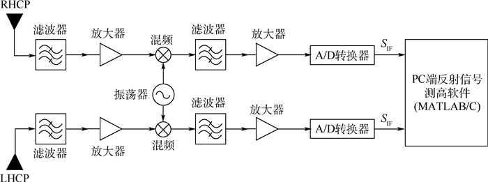
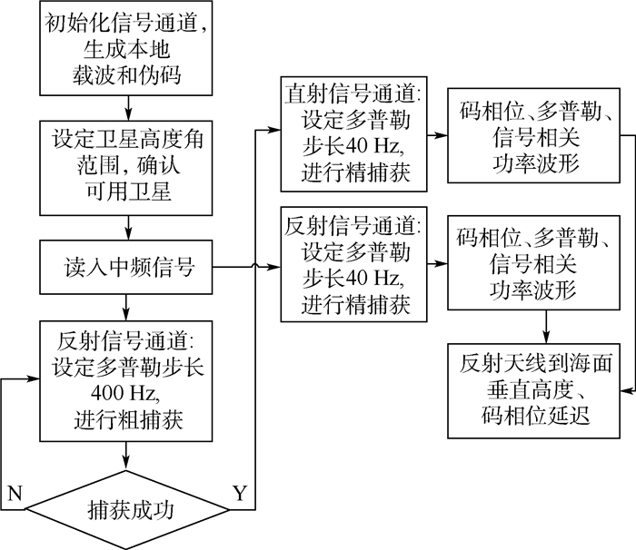
为了探究GNSS L1波段中信号不同调制方式的GNSS-R码相位延迟海面的测高性能,开展了双天线岸基GNSS-R海面测高实验,收集了采样率为40 MHz的原始中频数据。利用自主开发的GNSS-R测高软件接收机和反演软件对实验数据进行了处理分析,同时获得了基于QZSS L1C/A码和L1C码的GNSS-R海面测高结果,并分别与岸基同步观测的雷达高度计的测高值进行对比,以对反演结果进行精度评定。实验结果表明:基于QZSS L1C/A码和L1C码的海面测高精度最优可达0.63 m和0.4 m,L1C码的延迟GNSS-R测高精度明显高于L1C/A码。此外,GNSS-R测高精度会随着卫星高度角的增加而有所增加。
Abstract:In order to explore the altimetry performance of GNSS-R code phase delay measurement with different modulation methods in GNSS LI band signals, a coastal dual-antenna GNSS-R ocean altimetry experiment was carried out, and the original intermediate frequency data with a sampling rate of 40 MHz was collected. The experimental data was processed using the self-developed GNSS-R altimetry software receiver and inversion software, and the GNSS-R ocean altimetry results of QZSS L1C/A code and L1C code were obtained simultaneously. Then we compare them with the measured values of the radar altimeter that were simultaneously observed coastally, and used to evaluate the accuracy of the GNSS-R inversion result. The experimental results show that the ocean altimetry accuracy based on L1C/A code and L1C code is about 0.63 m and 0.4 m, respectively. It can be seen that the GNSS-R measurement accuracy of the L1C code delay is significantly higher than that of the L1C/A code. In addition, the accuracy of GNSS-R will be improved as the satellite elevation increases gradually.
-

图 6 L1C/A码和L1C码相关功率波形对比
Figure 6. Correlation power waveform comparison between L1C/A and L1C code

图 7 J1、J2、J3卫星高度角变化(北京时间)
Figure 7. J1, J2 and J3 satellite elevation changes(Beijing time)

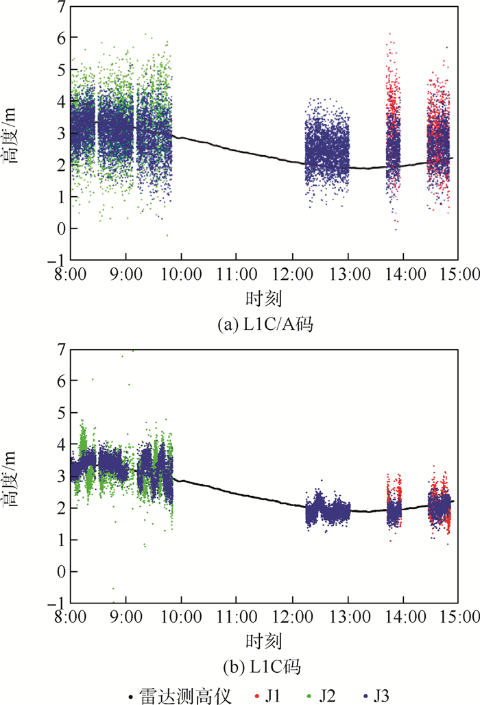
图 8 L1C/A和L1C码GNSS-R测高结果对比
Figure 8. Comparison of L1C/A and L1C code GNSS-Raltimetry results

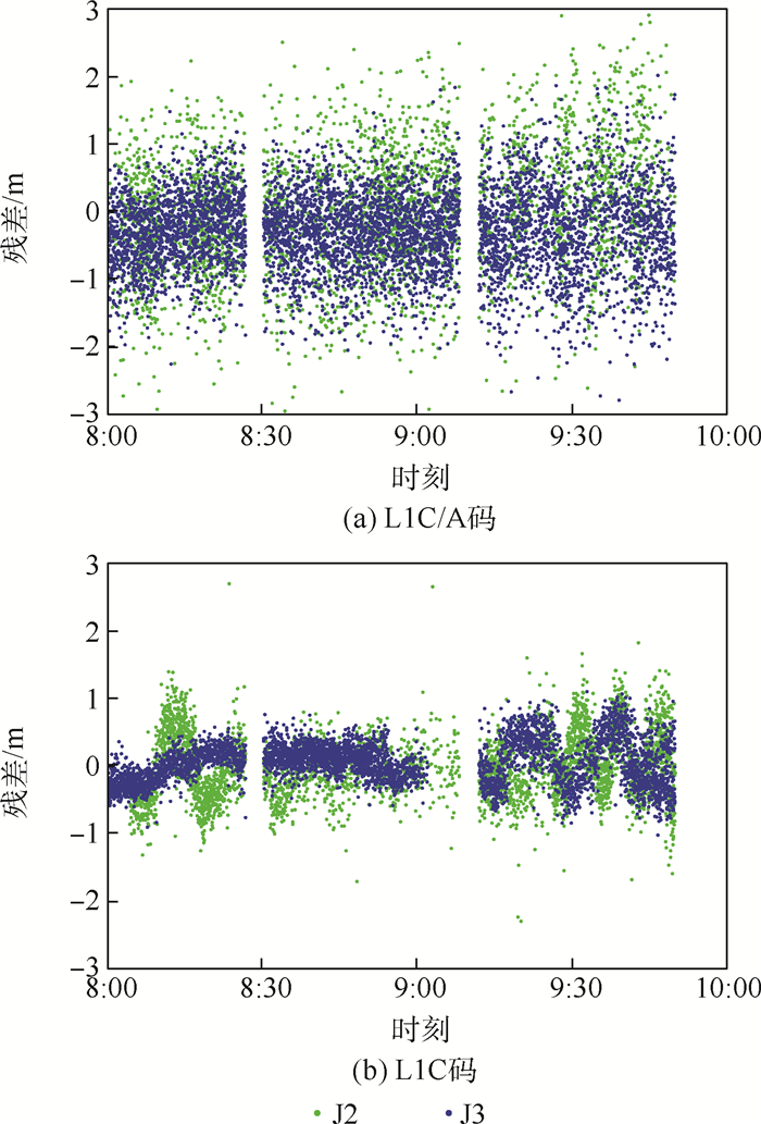
图 9 J2、J3岸基测高结果残差序列对比
Figure 9. Comparison of residual sequence of coastal altimetry results of J2 and J3 satellites

图 10 J1、J3码延迟岸基测高结果残差序列对比
Figure 10. Comparison of residual sequence of code delay coastal altimetry results of J1 and J3 satellites`
表 1 L1C/A码和L1C码信号结构
Table 1. Signal structures of L1C/A and L1C code
信号类型 信号分量 载波频率/MHz 码率/MHz 调制方式 码长 功率比 L1C/A 数据 1 575.42 1.023 BPSK 1 023 L1C 数据 1 575.42 1.023 BOC (1, 1) 10 230 1/4 导频 TMBOC (6, 1, 4/33) 10 230 3/4  下载: 导出CSV
表 2 J1、J2、J3码延迟和岸基测高结果精度对比
Table 2. Comparison of the accuracy of code delay coastal altimetry results of J1, J2 and J3 satellites
观测类型 时刻 PRN 均方根误差/m 标准差/m 最大误差/m 最小误差/m L1C/A 8:00—10:00 J2 0.917 0.908 2.977 -2.937 J3 0.634 0.597 2.134 -2.673 L1C J2 0.695 0.514 2.602 -2.341 J3 0.563 0.313 1.527 -0.609 L1C/A 13:30—15:00 J1 1.226 0.855 2.985 -1.728 J3 0.794 0.618 2.891 -1.977 L1C J1 0.726 0.391 1.846 -0.701 J3 0.395 0.226 1.164 -0.643
下载: 导出CSV
-
[1] MARTIN-NEIRA M. A passive reflectometry and interferometry system (PARIS): Application to ocean altimetry[J]. ESA Journal, 1993, 17(4): 331-355. [2] MARTIN-NEIRA M, CAPARRINI M, FONT-ROSSELLO J, et al. The PARIS concept: An experimental demonstration of sea surface altimetry using GPS reflected signals[J]. IEEE Transactions on Geoscience and Remote Sensing, 2001, 39(1): 142-150. doi: 10.1109/36.898676 [3] HELM A. Ground-based GPS altimetry with the L1 OpenGPS receiver using carrier phase-delay observations of reflected GPS signals[R]. Potsdam: Deutsches GeoForschungsZentrum GFZ, 2008: 67-85. [4] LOWE S T, ZUFFADA C, CHAO Y, et al. 5-cm-precision aircraft ocean altimetry using GPS reflections[J]. Geophysical Research Letters, 2002, 29(10): 1375-1378. [5] 白伟华, 孙越强, 朱光武, 等. 利用岸基GNSS-R信号反演湖面高度[C]//第一届中国卫星导航学术年会, 2010: 1646-1652.BAI W H, SUN Y Q, ZHU G W, et al. Lake surface height retrieve using coastal GNSS-R signals[C]//Proceedings of the First China Satellite Navigation Conference, 2010: 1646-1652(in Chinese). [6] CARDELLACH E, RIUS A, MARTIN-NEIRA M, et al. Consolidating the precision of interferometric GNSS-R ocean altimetry using airborne experimental data[J]. IEEE Transactions on Geoscience and Remote Sensing, 2014, 52(8): 4992-5004. doi: 10.1109/TGRS.2013.2286257 [7] PASCUAL D, CAMPS A, MARTIN F, et al. Precision bounds in GNSS-R ocean altimetry[J]. IEEE Journal of Selected Topics in Applied Earth Observations and Remote Sensing, 2014, 7(5): 1416-1423. doi: 10.1109/JSTARS.2014.2303251 [8] SEMMLING A M, BECKHEINRICH J, WICKERT J, et al. Sea surface topography retrieved from GNSS reflectometry phase data of the GEOHALO flight mission[J]. Geophysical Research Letters, 2014, 41(3): 954-960. doi: 10.1002/2013GL058725 [9] 王娜子, 鲍李峰, 高凡. 逐历元GNSS-R测高单差和双差算法[J]. 测绘学报, 2016, 45(7): 795-802. https://www.cnki.com.cn/Article/CJFDTOTAL-CHXB201607007.htmWANG N Z, BAO L F, GAO F. Improved water level retrieval from epoch-by-epoch single and double difference GNSS-R algorithms[J]. Acta Geodaetica et Cartographica Sinica, 2016, 45(7): 795-802(in Chinese). https://www.cnki.com.cn/Article/CJFDTOTAL-CHXB201607007.htm [10] LOWE S T, ZUFFADA C, LABRECQUE J L, et al. An ocean-altimetry measurement using reflected GPS signals observed from a low-altitude aircraft[C]//2000 IEEE International Geoscience and Remote Sensing Symposium. Piscataway: IEEE Press, 2000: 2185-2187. [11] ZHANG Y, TIAN L, MENG W, et al. Feasibility of code level altimetry using coastal BeiDou-reflection (BeiDou-R) setups[J]. IEEE Journal of Selected Topics in Applied Earth Observations and Remote Sensing, 2015, 8(8): 4130-4140. doi: 10.1109/JSTARS.2015.2446684 [12] ZHANG Y, LIU F, GU Q, et al. Study of accurate ocean-altimetry with GNSS-R[C]//2013 IEEE International Geoscience and Remote Sensing Symposium. Piscataway: IEEE Press, 2013: 1410-1413. [13] GAO F, XU T H, WANG N Z, et al. A shipborne experiment using a dual-antenna reflectometry system for GPS/BDS code delay measurements[J]. Journal of Geodesy, 2020, 94(9): 1-18. [14] D'ADDIO S, BUCK C, MARTINNEIRA M. Paris altimetry precision prediction with Galileo signals-in-Space[C]//2008 IEEE International Geoscience and Remote Sensing Symposium. Piscataway: IEEE Press, 2008: 1410-1414. [15] 杨东凯, 张其善. GNSS反射信号处理基础与实践[M]. 北京: 电子工业出版社, 2012: 127-142.YANG D K, ZHANG Q S. GNSS reflected signal processing: Basics and practice[M]. Beijing: Publishing House of Electronics Industry, 2012: 127-142(in Chinese). [16] 姚铮, 陆明泉. 新一代卫星导航系统信号设计原理与实现技术[M]. 北京: 电子工业出版社, 2016: 82-114.YAO Z, LU M Q. The signal design principle and realization technology of the new generation satellite navigation system[M]. Beijing: Publishing House of Electronics Industry, 2016: 82-114(in Chinese). [17] Japan Cabinet Office. Performance standard and interface specification: IS-QZSS-PNT-003[S/OL]. (2018-11-05)[2020-11-01]. https://qzss.go.jp/en/technical/ps-is-qzss/ps-is-qzss.html. [18] BETZJ W. Binary offset carrier modulations for radionavigation[J]. Navigation, 2001, 48(4): 227-246. doi: 10.1002/j.2161-4296.2001.tb00247.x [19] SHANNON C E. A mathematical theory of communication[J]. Bell System Technical Journal, 1948, 27(3): 379-423. doi: 10.1002/j.1538-7305.1948.tb01338.x -

 下载:
下载:


 点击查看大图

计量
- 文章访问数: 517
- HTML全文浏览量: 197
- PDF下载量: 55
- 被引次数: 0
