


Path planning algorithm for airborne pseudolites installed on stratospheric airships
-
摘要:
几何布局对空基伪卫星导航系统至关重要,然而以往对其布局路径研究较少。为此,以基于平流层飞艇的空基伪卫星用最小能源代价获取最优导航服务效果为目标,分析了空基伪卫星几何布局对导航定位精度的影响,研究了平流层飞艇动力学模型、风场模型、能源消耗模型,阐述了基于平流层飞艇的空基伪卫星路径规划空间建立方法与路径表示方法,设计了融合导航定位精度指标和平流层飞艇能源消耗指标的路径规划代价函数,并在经典A*路径规划算法基础上,构建了基于平流层飞艇的空基伪卫星路径规划算法,针对多种输入条件对算法进行了仿真验证。仿真结果表明:所提路径规划算法可以有效改善伪卫星网络几何精度因子,同时大幅降低平流层飞艇的能源消耗。
Abstract:Airborne pseudolite navigation systems depend on geometry configuration, however previous research on how to create the ideal geometry configuration with the least amount of energy was limited. To solve this problem, the path planning algorithm of airborne pseudolite installed on stratospheric airships was discussed in this paper. First, the effect of pseudolite geometry configuration on positioning precision was analyzed. Second, the stratospheric airship dynamic model, wind field model and stratospheric airship energy consumption model were studied. Thirdly, a grid-based strategy for planning space establishment and path representation was described. Furthermore, a novel cost function for stratospheric airship path planning comprising positioning precision index and energy consumption index was designed. Based on the classic A* algorithm, a path planning algorithm for airborne pseudolite installed on a stratospheric airship was constructed. And finally, simulations were executed with various inputs to verify the proposed algorithm. The outcomes of the simulations demonstrated that the suggested approach may effectively increase geometric precision improvement while lowering stratospheric airship energy consumption.
-

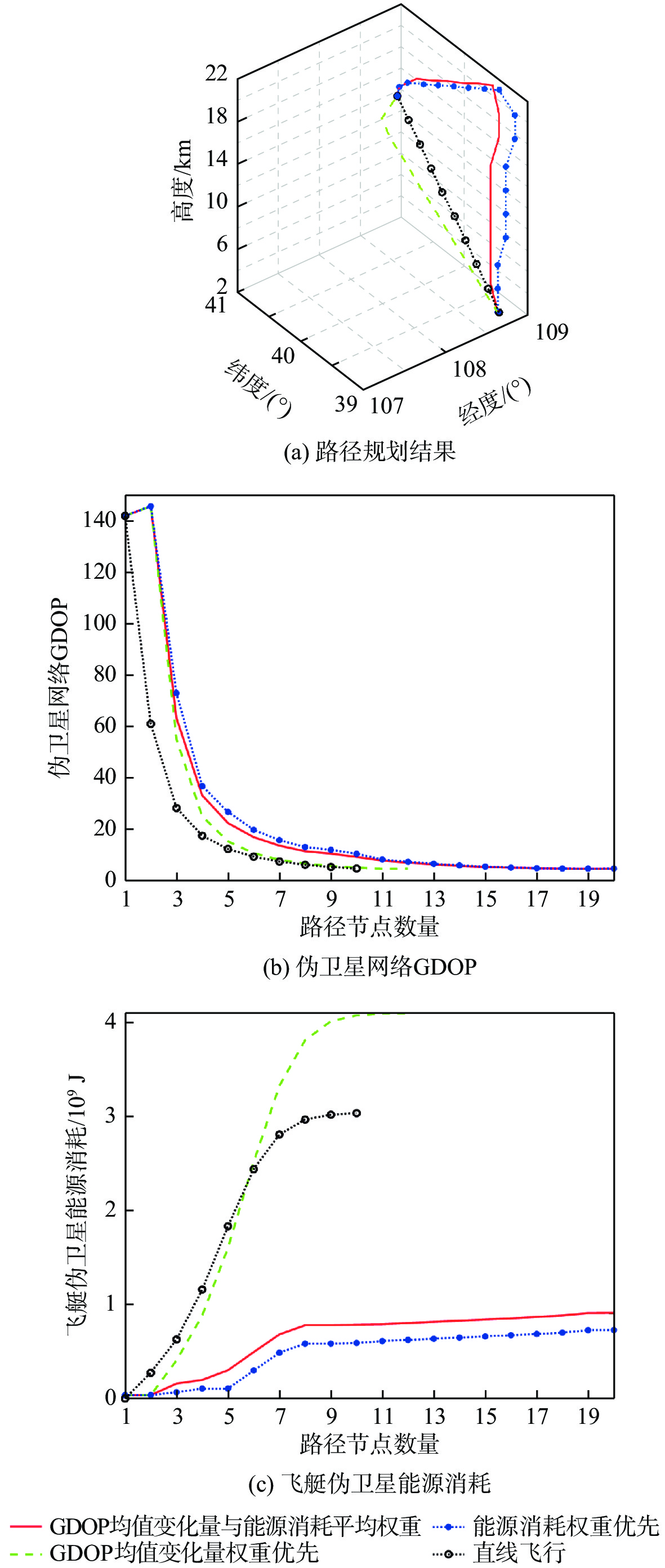
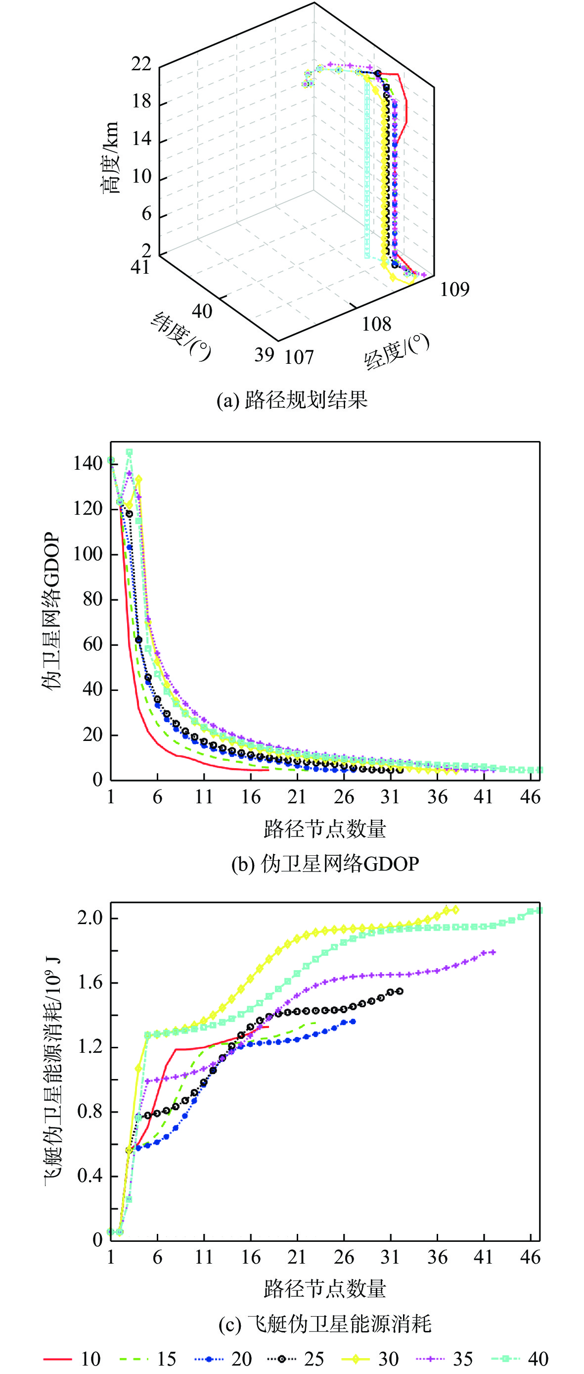
图 2 路径规划结果与直线飞行路径的对比
Figure 2. Comparison among path planning results and rectilinear flight path
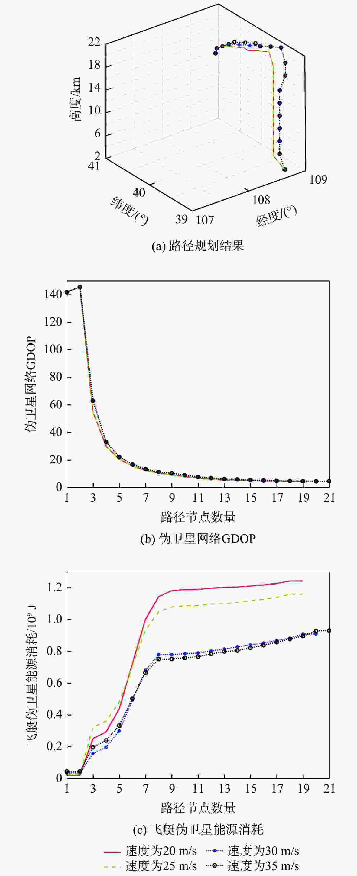
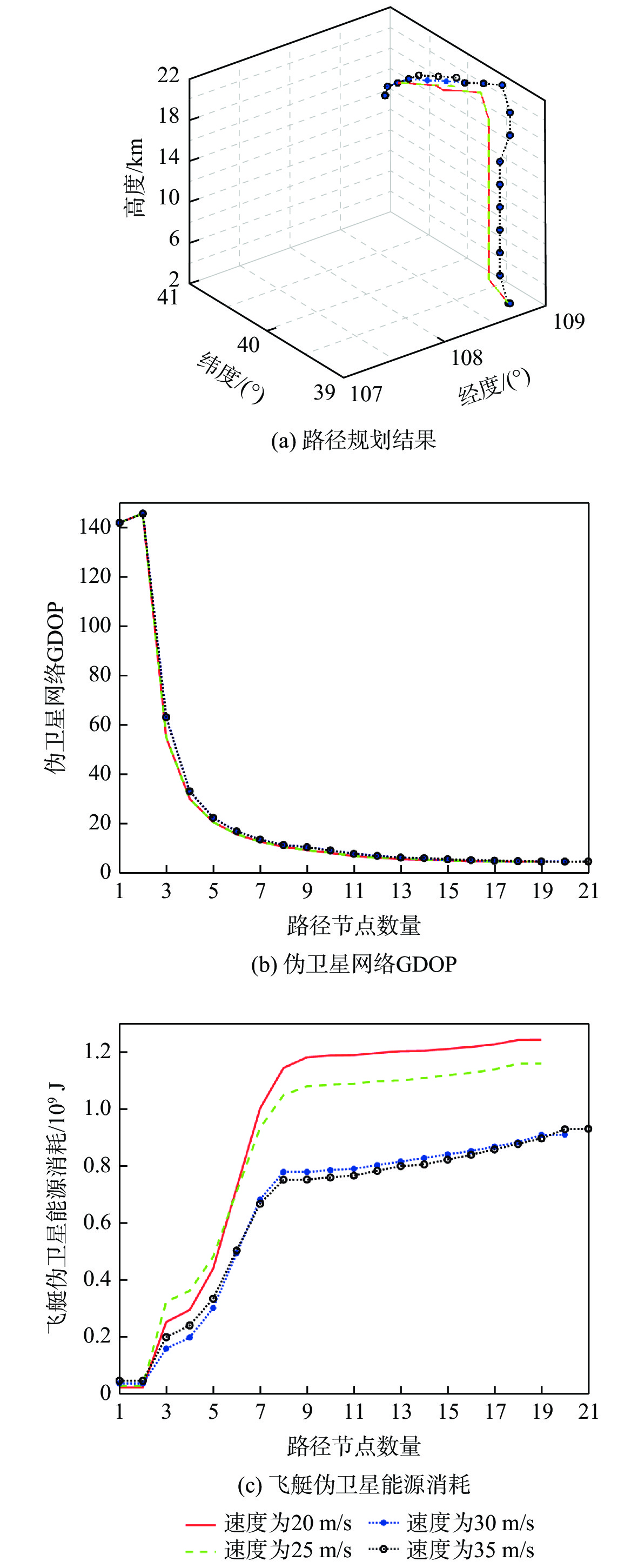
图 3 不同飞行速度的路径规划结果对比
Figure 3. Comparison among path planning results of different flight speeds
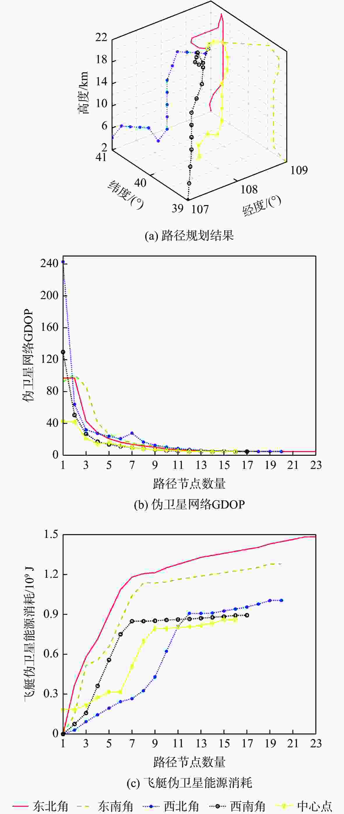
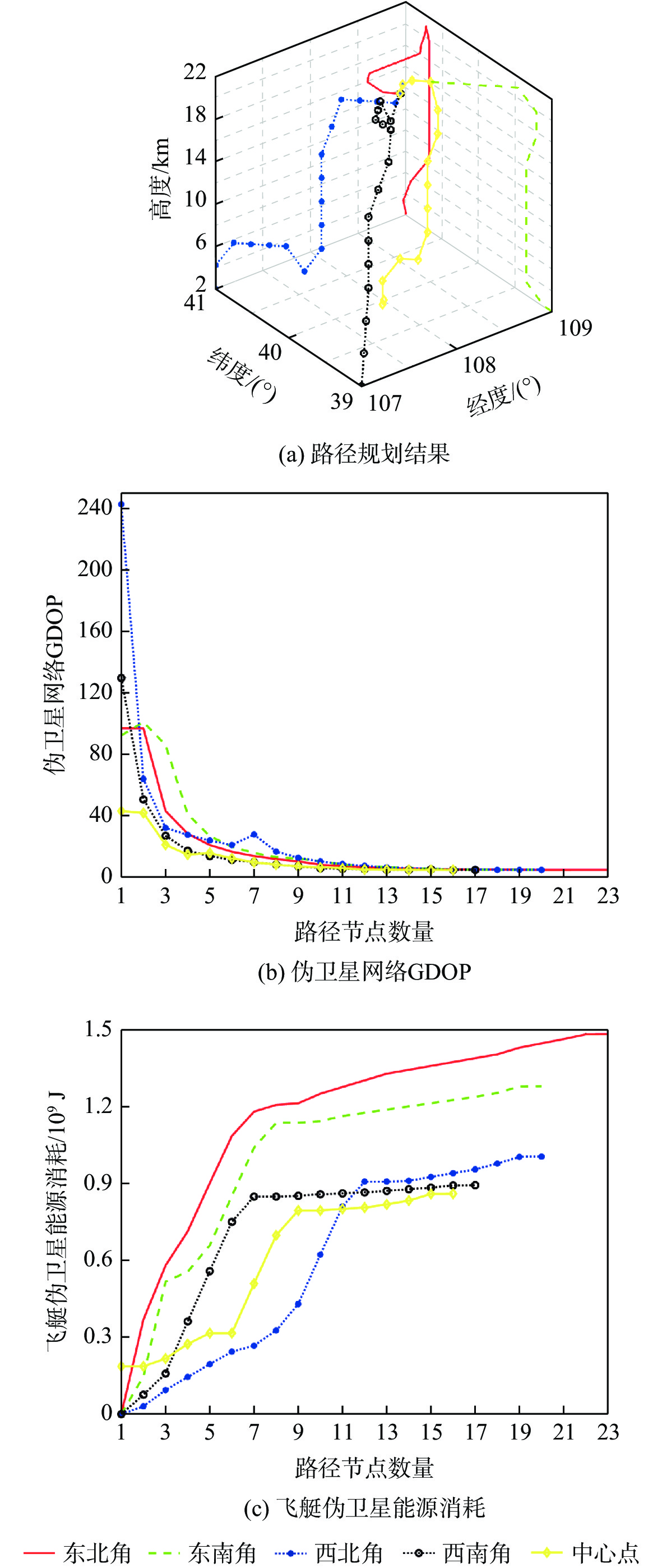
图 4 不同规划起点的路径规划结果对比
Figure 4. Comparison among path planning results of different planning starting points
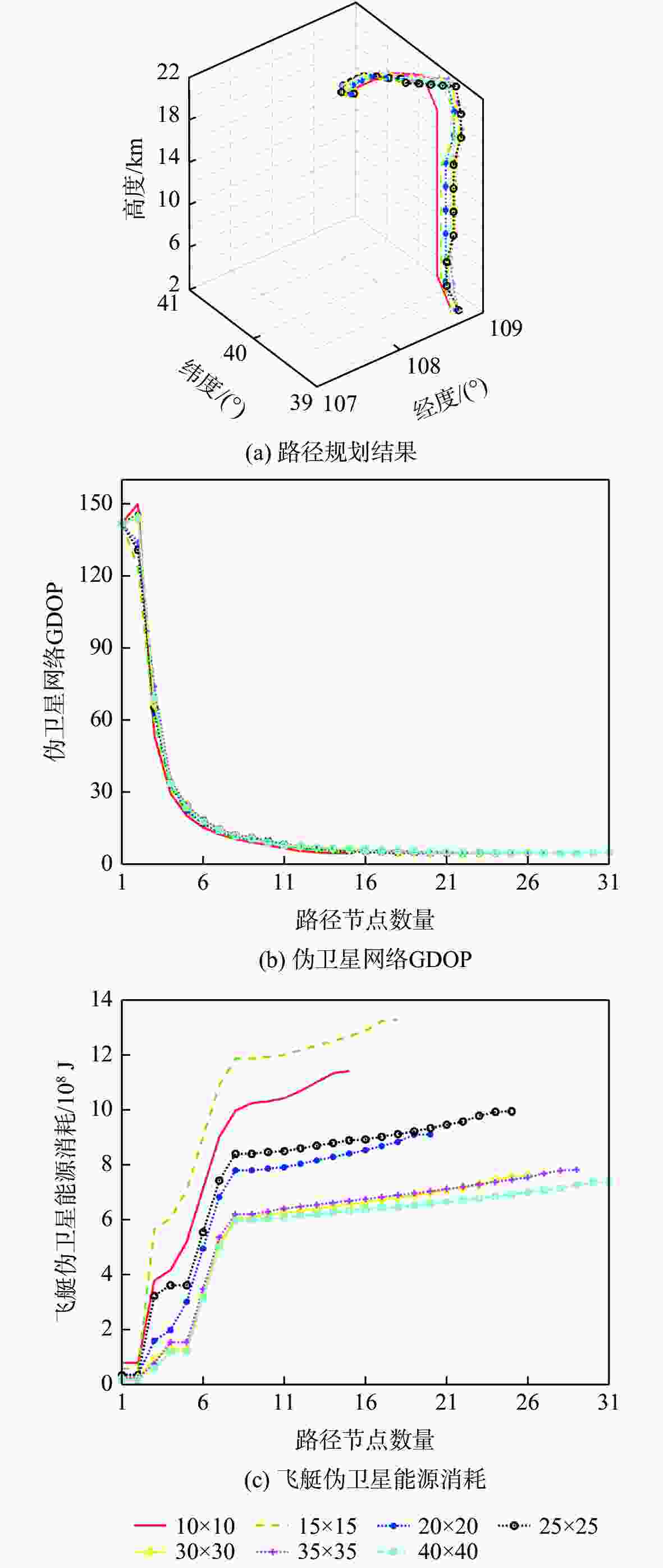
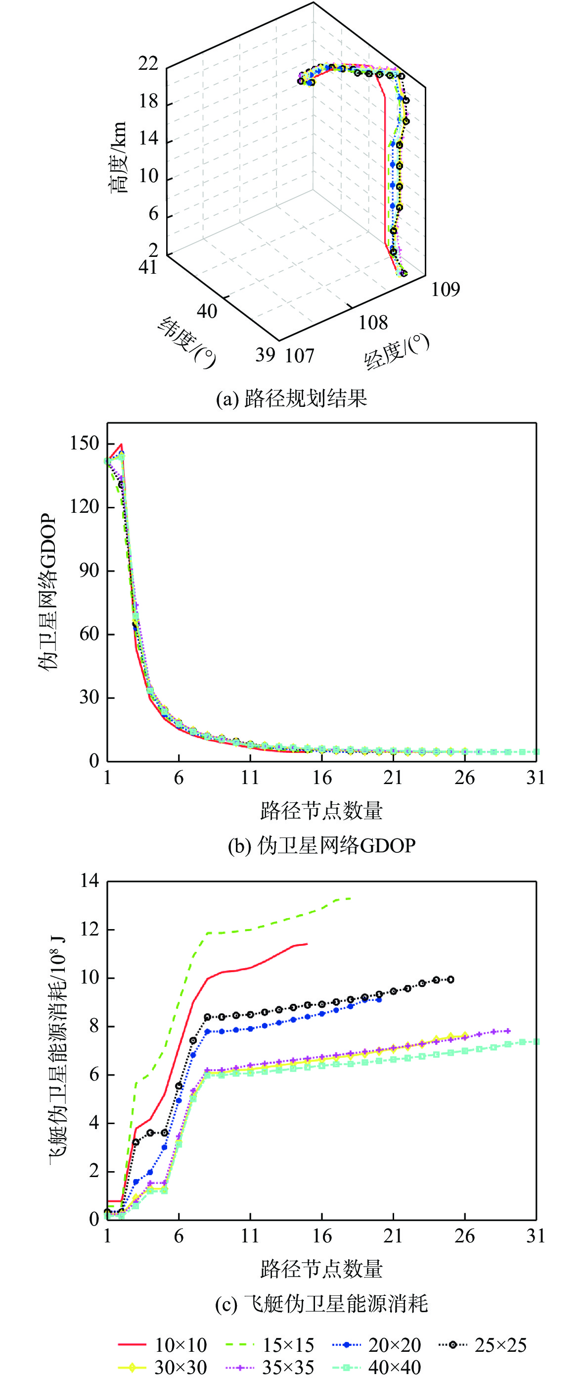
图 5 不同水平方向网格数量的路径规划结果对比
Figure 5. Comparison among path planning results of different numbers of grids in horizontal direction
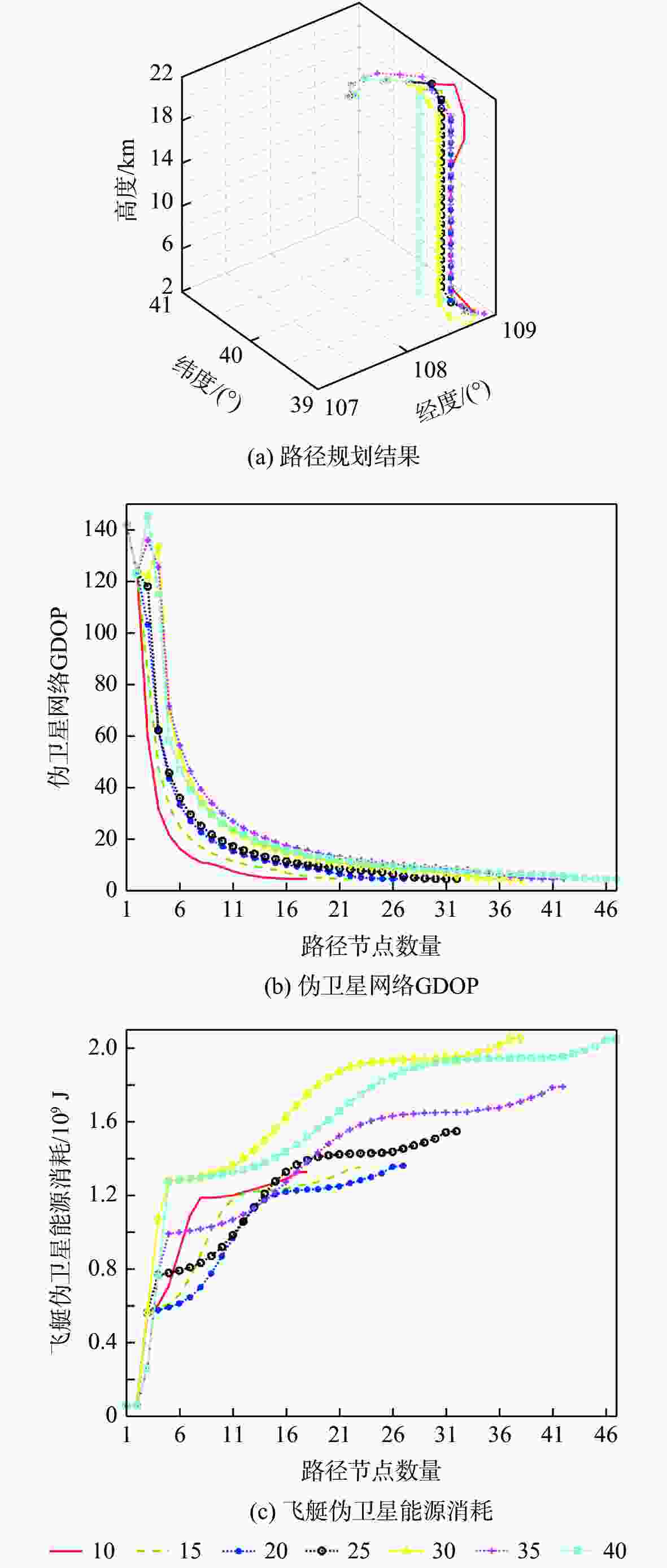
图 6 不同垂直方向网格数量的路径规划结果对比
Figure 6. Comparison among path planning results of different numbers of grids in vertical direction
表 1 路径规划结果与直线飞行路径性能比较
Table 1. Performance comparison among path planning results and rectilinear flight path
路径类别 能源消耗/J 路径GDOP均值 GDOP均值变化量与能源
消耗平均权重9.11×10⁸ 20.18 GDOP均值变化量权重优先 4.10×10⁹ 26.09 能源消耗权重优先 7.29×10⁸ 21.67 直线飞行 3.04×10⁹ 29.46  下载: 导出CSV
表 2 不同飞行速度的路径规划结果性能比较
Table 2. Performance comparison among path planning results of different flight speeds
飞行速度/(m·s−1) 能源消耗/J 路径GDOP均值 20 1.24×10⁹ 26.27 25 1.16×10⁹ 26.29 30 9.11×10⁸ 26.27 35 9.31×10⁸ 25.30
下载: 导出CSV
表 3 不同规划起点的路径规划结果性能比较
Table 3. Performance comparison among path planning results of different planning starting points
规划起点 能源消耗/J 路径GDOP均值 东北角 1.48×10⁹ 18.12 东南角 1.28×10⁹ 23.84 西北角 1.01×10⁹ 26.88 西南角 8.94×10⁸ 18.58 中心点 8.61×10⁸ 13.15
下载: 导出CSV
表 4 不同水平方向网格数量的路径规划结果性能比较
Table 4. Performance comparison among path planning results with different numbers of grids in horizontal direction
水平方向网格数量 能源消耗/J 路径GDOP均值 10×10 1.14×10⁹ 31.89 15×15 1.33×10⁹ 26.87 20×20 9.11×10⁸ 26.27 25×25 9.95×10⁸ 21.94 30×30 7.62×10⁸ 21.89 35×35 7.82×10⁸ 20.09 40×40 7.39×10⁸ 19.16
下载: 导出CSV
表 5 不同垂直方向网格数量的路径规划结果性能比较
Table 5. Performance comparison among path planning results with different numbers of grids in vertical direction
垂直方向
网格数量能源消耗/J 路径GDOP均值 10 1.33×10⁹ 26.87 15 1.35×10⁹ 26.63 20 1.36×10⁹ 27.46 25 1.55×10⁹ 25.82 30 2.05×10⁹ 28.30 35 1.79×10⁹ 28.18 40 2.05×10⁹ 24.31
下载: 导出CSV
-
[1] 黄声享, 刘贤三, 刘文建, 等. 伪卫星技术及其应用[J]. 测绘信息与工程, 2006, 31(2): 49-51. doi: 10.3969/j.issn.1007-3817.2006.02.020HUANG S X, LIU X S, LIU W J, et al. Discussion on the pseudolite technology and its applications[J]. Journal of Geomatics, 2006, 31(2): 49-51(in Chinese). doi: 10.3969/j.issn.1007-3817.2006.02.020 [2] 赵娜, 赵伟, 孙妍, 等. 伪卫星技术及其在导航定位中的应用分析[J]. 导航定位学报, 2014, 2(1): 82-86. doi: 10.3969/j.issn.2095-4999.2014.01.018ZHAO N, ZHAO W, SUN Y, et al. Analysis of the pseudolite technique and its application in satellite navigation system[J]. Journal of Navigation and Positioning, 2014, 2(1): 82-86(in Chinese). doi: 10.3969/j.issn.2095-4999.2014.01.018 [3] LEE H K, WANG J, RIZOS C. An integer ambiguity resolution procedure for GPS/pseudolite/INS integration[J]. Journal of Geodesy, 2005, 79(4): 242-255. [4] 宋建材. GNSS/伪卫星组合导航技术研究[D]. 天津: 天津大学, 2017: 49-71.SONG J C. Study on integrated navigation of GNSS/pseudolite [D]. Tianjin: Tianjin University, 2017: 49-71(in Chinese) . [5] TOSHIAKI T, MASATOSHI H, JOEL B, et al. Experiments of inverted pseudolite positioning for airship-based GPS augmentation system [C]//Proceedings of the 15th International Technical Meeting of the Satellite Division of the U. S. Institute of Navigation. Manassas: Institute of Navigation, 2002: 1689-1695. [6] 蔚保国, 何成龙. 空地协同伪卫星导航增强系统评估方法[J]. 华中科技大学学报(自然科学版), 2017, 45(1): 113-117. doi: 10.13245/j.hust.170121YU B G, HE C L. Assessment of air-ground cooperation pseudolites augmentation system[J]. Journal of Huazhong University of Science and Technology (Natural Science Edition), 2017, 45(1): 113-117(in Chinese). doi: 10.13245/j.hust.170121 [7] 刘源. 伪卫星网络定位算法研究[D]. 成都: 西南交通大学, 2017: 21-26.LIU Y. Research on positioning algorithms in pseudolite network[D]. Chengdu: Southwest Jiaotong University, 2017: 21-26(in Chinese). [8] 薛晓峰. 独立组网的地基伪卫星定位系统的设计与应用[D]. 长沙: 湖南大学, 2019: 49-50.XUE X F. Design and application of positioning system only by ground-based pseudolite[D]. Changsha: Hunan University, 2019: 49-50 (in Chinese). [9] 刘芹丽, 马刘海, 李春霞. 一种新型高精度地基伪卫星定位系统: Locata[J]. 全球定位系统, 2014, 39(4): 37-41.LIU Q L, MA L H, LI C X. A new high precision ground-based pseudolite positioning system-locata[J]. GNSS World of China, 2014, 39(4): 37-41(in Chinese). [10] CHANDU B, PANT R, MOUDGALYA K. Modeling and simulation of a precision navigation system using pseudolites mounted on airships[C]//7th AIAA ATIO Conference, 2nd CEIAT International Conference on Innovation and Integration in Aerospace Sciences, 17th LTA Systems Technical Conference. Reston: AIAA, 2007. [11] 呼玮, 杨建军, 何苹. 基于临近空间飞艇定位的伪卫星布局研究[J]. 无线电工程, 2009, 39(10): 24-27. doi: 10.3969/j.issn.1003-3106.2009.10.009HU W, YANG J J, HE P. Study on pseudolite configuration scheme based on near space airships[J]. Radio Engineering of China, 2009, 39(10): 24-27(in Chinese). doi: 10.3969/j.issn.1003-3106.2009.10.009 [12] 杨峻巍. 基于临近空间飞行器的区域导航系统关键技术分析[J]. 电讯技术, 2014, 54(4): 385-391. doi: 10.3969/j.issn.1001-893x.2014.04.002YANG J W. Analysis of key techniques of regional navigation system based on near space vehicle[J]. Telecommunication Engineering, 2014, 54(4): 385-391(in Chinese). doi: 10.3969/j.issn.1001-893x.2014.04.002 [13] 何夏. 基于临近空间组网节点的伪卫星导航关键技术研究[D]. 成都: 电子科技大学, 2014: 9-17.HE X. Reseach on the key technology of pseudolite navigation based on near space network node[D]. Chengdu: University of Electronic Science and Technology of China, 2014: 9-17(in Chinese). [14] 高社生, 赵飞, 谢梅林. 临近空间伪卫星独立组网几何布局研究[J]. 导航定位学报, 2013, 1(4): 21-25. doi: 10.3969/j.issn.2095-4999.2013.04.006GAO S S, ZHAO F, XIE M L. Research on the geometric configuration scheme of near space pseudolite-only positioning system[J]. Journal of Navigation and Positioning, 2013, 1(4): 21-25(in Chinese). doi: 10.3969/j.issn.2095-4999.2013.04.006 [15] 吴小婧, 张晓坤, 邓平科, 等. 多平台BDS导航增强网络配置探讨[J]. 导航定位学报, 2018, 6(4): 51-56. doi: 10.16547/j.cnki.10-1096.20180410WU X J, ZHANG X K, DENG P K, et al. Discussion on configuration of multi platform BDS navigation enhanced network[J]. Journal of Navigation and Positioning, 2018, 6(4): 51-56(in Chinese). doi: 10.16547/j.cnki.10-1096.20180410 [16] 宫常青, 吴晓联, 刘勇. 近地空间伪卫星定位系统浮空器节点构型分析[J]. 解放军理工大学学报(自然科学版), 2011, 12(2): 125-128.GONG C Q, WU X L, LIU Y. Analysis of airships’ nodes configuration in near-space navigation and positioning system[J]. Journal of PLA University of Science and Technology (Natural Science Edition), 2011, 12(2): 125-128(in Chinese). [17] 高宏, 邓志鑫, 王立兵, 等. 空基导航区域增强系统覆盖范围分析[J]. 无线电工程, 2017, 47(2): 45-47. doi: 10.3969/j.issn.1003-3106.2017.02.11GAO H, DENG Z X, WANG L B, et al. Coverage analysis of air-based regional augmentation system for BD satellite navigation signal[J]. Radio Engineering, 2017, 47(2): 45-47(in Chinese). doi: 10.3969/j.issn.1003-3106.2017.02.11 [18] 刘雅娟. 临近空间定位浮空平台空间布局方案初探[J]. 无线电工程, 2008, 38(11): 29-30. doi: 10.3969/j.issn.1003-3106.2008.11.010LIU Y J. Research on space distribution scheme of near space positioning platform station[J]. Radio Engineering of China, 2008, 38(11): 29-30(in Chinese). doi: 10.3969/j.issn.1003-3106.2008.11.010 [19] 杨一, 高社生, 阎海峰. 临近空间伪卫星几何布局方案设计[J]. 系统工程与电子技术, 2014, 36(3): 532-538.YANG Y, GAO S S, YAN H F. Design on geometric configuration schemes of pseudolite in near space[J]. Systems Engineering and Electronics, 2014, 36(3): 532-538(in Chinese). [20] LI D P, DENG P K, LIU B, et al. Research on the dynamic configuration of air-based pseudolite network[C]//SUN J, LIU J, FAN S, et al. China Satellite Navigation Conference (CSNC) 2015 Proceedings: Volume II. Berlin: Springer, 2015: 357-367. [21] 杨龙, 周建华, 陈金平. 基于遗传算法的空基导航信号增强平台组网优化方法研究[J]. 全球定位系统, 2008, 33(3): 9-13. doi: 10.3969/j.issn.1008-9268.2008.03.003YANG L, ZHOU J H, CHEN J P. The study of optimization of formation flying navigation augmentation platforms based on genetic algorithm[J]. GNSS World of China, 2008, 33(3): 9-13(in Chinese). doi: 10.3969/j.issn.1008-9268.2008.03.003 [22] 李东新, 彭云, 常青, 等. 基于粒子群算法的伪卫星布站优化设计[J]. 导航定位与授时, 2015, 2(5): 44-51. doi: 10.3969/j.issn.2095-8110.2015.05.008LI D X, PENG Y, CHANG Q, et al. Optimal design of pseudo-satellite station based on particle swarm optimization algorithm[J]. Navigation Positioning and Timing, 2015, 2(5): 44-51(in Chinese). doi: 10.3969/j.issn.2095-8110.2015.05.008 [23] 郭丽, 张雪, 郭熙业. 地基导航系统高性能快速定位算法[J]. 全球定位系统, 2018, 43(6): 64-68. doi: 10.13442/j.gnss.1008-9268.2018.06.011GUO L, ZHANG X, GUO X Y. High performance and fast positioning algorithm for ground-based navigation systems[J]. GNSS World of China, 2018, 43(6): 64-68(in Chinese). doi: 10.13442/j.gnss.1008-9268.2018.06.011 [24] TIWARY K, BEHERA S, SHARADA G, et al. Modelling and simulation of pseudolite-based navigation: A GPS-independent radio navigation system[J]. Defence Science Journal, 2010, 60(5): 541-550. doi: 10.14429/dsj.60.577 [25] 孟立凡, 蓝金辉. 传感器原理与应用[M]. 北京: 电子工业出版社, 2007.MENG L F, LAN J H. Principle and application of sensor[M]. Beijing: Publishing House of Electronics Industry, 2007(in Chinese). [26] 孟键, 孙付平, 丛佃伟. 伪卫星增强区域卫星导航系统组网仿真[J]. 测绘科学技术学报, 2008, 25(3): 213-215.MENG J, SUN F P, CONG D W. Plans of augmenting regional satellite navigation using PLs[J]. Journal of Geomatics Science and Technology, 2008, 25(3): 213-215(in Chinese). [27] 史海青, 郁丰. 基于遗传算法的蜂窝广域空基伪卫星网络布局优化[J]. 兵工自动化, 2013, 32(9): 68-72. doi: 10.7690/bgzdh.2013.09.019SHI H Q, YU F. Wide area cellular network layout optimization of air-borne pseudo based on genetic algorithm[J]. Ordnance Industry Automation, 2013, 32(9): 68-72(in Chinese). doi: 10.7690/bgzdh.2013.09.019 [28] 史海青. 北斗伪卫星空基增强网络优化与高精度动态时间同步[D]. 南京: 南京航空航天大学, 2014.SHI H Q. Research on enhancement network optimization and precise timing synchronization for air-borne pseudo-satellites of Beidou [D]. Nanjing: Nanjing University of Aeronautics and Astronautics, 2014(in Chinese). [29] 曾凌川, 李大朋, 曲艺, 等. 空基伪卫星组网部署的航路规划算法[J]. 北京航空航天大学学报, 2016, 42(7): 1388-1397. doi: 10.13700/j.bh.1001-5965.2015.0477ZENG L C, LI D P, QU Y, et al. Route planning algorithm for configuring airborne Pseudolites[J]. Journal of Beijing University of Aeronautics and Astronautics, 2016, 42(7): 1388-1397(in Chinese). doi: 10.13700/j.bh.1001-5965.2015.0477 [30] 谭龙玉. 基于飞行器群独立动态组网的北斗伪卫星系统研究[D]. 南京: 南京航空航天大学, 2013.TAN L Y. Research on pseudolite system for Beidou based on independent and dynamic aircrafts configuration[D]. Nanjing: Nanjing University of Aeronautics and Astronautics, 2013(in Chinese). [31] MUELLER J B, ZHAO Y J, GARRARD W L. Optimal ascent trajectories for stratospheric airships using wind energy[J]. Journal of Guidance, Control, and Dynamics, 2009, 32(4): 1232-1245. doi: 10.2514/1.41270 [32] 李魁, 邓小龙, 杨希祥, 等. 基于平流层风场预测的浮空器轨迹控制[J]. 北京航空航天大学学报, 2019, 45(5): 1008-1018. doi: 10.13700/j.bh.1001-5965.2018.0538LI K, DENG X L, YANG X X, et al. Trajectory control of aerostat based on prediction of stratospheric wind field[J]. Journal of Beijing University of Aeronautics and Astronautics, 2019, 45(5): 1008-1018(in Chinese). doi: 10.13700/j.bh.1001-5965.2018.0538 [33] ZHAO Y Y, GARRARD W, MUELLER J. Benefits of trajectory optimization in airship flights[C]//AIAA 3rd "Unmanned Unlimited" Technical Conference, Workshop and Exhibit. Reston: AIAA, 2004. [34] KAMPKE T, ELFES A. Optimal aerobot trajectory planning for wind-based opportunistic flight control[C]//Proceedings 2003 IEEE/RSJ International Conference on Intelligent Robots and Systems (IROS 2003). Piscataway: IEEE Press, 2003: 67-74. [35] LEE S, BANG H. Three-dimensional ascent trajectory optimization for stratospheric airship platforms in the jet stream[J]. Journal of Guidance, Control, and Dynamics, 2007, 30(5): 1341-1351. doi: 10.2514/1.27344 [36] 李峰, 叶正寅. 平流层飞艇空气动力学研究进展[J]. 华东交通大学学报, 2008, 25(1): 24-27. doi: 10.3969/j.issn.1005-0523.2008.01.007LI F, YE Z Y. Advances in aerodynamics research of stratospheric airship[J]. Journal of East China Jiaotong University, 2008, 25(1): 24-27(in Chinese). doi: 10.3969/j.issn.1005-0523.2008.01.007 [37] 常晓飞, 白云飞, 符文星, 等. 基于平流层特殊风场的浮空器定点方案研究[J]. 西北工业大学学报, 2014, 32(1): 12-17.CHANG X F, BAI Y F, FU W X, et al. Research on fixed-point aerostat based on its special stratosphere wind field[J]. Journal of Northwestern Polytechnical University, 2014, 32(1): 12-17(in Chinese). [38] 孙帅, 李智斌, 田科丰. 考虑风场条件的一类平流层飞艇返回过程建模与航迹规划研究[J]. 空间控制技术与应用, 2014, 40(4): 37-41. doi: 10.3969/j.issn.1674-1579.2014.04.007SUN S, LI Z B, TIAN K F. Modeling and trajectory planning of return process for a class of airship with wind field[J]. Aerospace Control and Application, 2014, 40(4): 37-41(in Chinese). doi: 10.3969/j.issn.1674-1579.2014.04.007 [39] 吴雷, 李勇, 李智斌. 基于遗传算法的平流层飞艇航迹规划方法研究[J]. 航天返回与遥感, 2011, 32(1): 1-6. doi: 10.3969/j.issn.1009-8518.2011.01.001WU L, LI Y, LI Z B. The research of route planning for stratospheric airships based on genetic algorithms[J]. Spacecraft Recovery & Remote Sensing, 2011, 32(1): 1-6(in Chinese). doi: 10.3969/j.issn.1009-8518.2011.01.001 [40] 周革. 平流层飞艇变质心控制研究[D]. 上海: 上海交通大学, 2012.ZHOU G. Moving mass control for stratospheric airship[D]. Shanghai: Shanghai Jiao Tong University, 2012(in Chinese). [41] 李思海, 白存儒. 基于遗传算法的飞行器航迹规划研究[J]. 华东交通大学学报, 2007, 24(4): 147-151. doi: 10.3969/j.issn.1005-0523.2007.04.040LI S H, BAI C R. The research of route planning for air vehicle based on genetic algorithms[J]. Journal of East China Jiaotong University, 2007, 24(4): 147-151(in Chinese). doi: 10.3969/j.issn.1005-0523.2007.04.040 [42] 张广林, 胡小梅, 柴剑飞, 等. 路径规划算法及其应用综述[J]. 现代机械, 2011(5): 85-90. doi: 10.3969/j.issn.1002-6886.2011.05.031ZHANG G L, HU X M, CHAI J F, et al. Summary of path planning algorithm and its application[J]. Modern Machinery, 2011(5): 85-90(in Chinese). doi: 10.3969/j.issn.1002-6886.2011.05.031 [43] 黄西洲, 王蕾. 基于实时交通信息的动态路径规划算法性能比较[J]. 微计算机信息, 2012, 28(9): 497-498.HUANG X Z, WANG L. Performance comparison of dynamic route planning based on real time traffic information[J]. Microcomputer Information, 2012, 28(9): 497-498(in Chinese). [44] 刘佳, 王杰. 无人水面艇避障路径规划算法综述[J]. 计算机应用与软件, 2020, 37(8): 1-10. doi: 10.3969/j.issn.1000-386x.2020.08.001LIU J, WANG J. Overview of obstacle avoidance path planning algorithm for unmanned surface vehicle[J]. Computer Applications and Software, 2020, 37(8): 1-10(in Chinese). doi: 10.3969/j.issn.1000-386x.2020.08.001 [45] National Oceanic and Atmospheric Administration. U. S. standard atmosphere[S]. Washington, D. C. : NOAA, NASA, USAF, 1976. -

 下载:
下载:

 点击查看大图
计量
- 文章访问数: 316
- HTML全文浏览量: 80
- PDF下载量: 37
- 被引次数: 0
