


GNSS-MR snow depth inversion method based on variational mode decomposition and moving average
-
摘要:
针对利用全球卫星导航系统多径反射(GNSS-MR)技术反演雪深过程中信噪比(SNR)序列趋势项分离不佳和反演结果波动较大的问题,提出一种基于变分模态分解(VMD)和移动平均(MA)的雪深反演方法。VMD算法通过自适应高通滤波有效分离SNR序列的趋势项,MA算法对初始反演结果进行平滑处理从而减少随机波动。选用瑞典KIRU站2021年前5个月GLONASS不同频段的SNR观测值开展实验,研究所提方法的可行性。结果表明:基于VMD算法的反演结果与气象站原位雪深相关系数超过0.95,均方根误差(RMSE)最低约5 cm,较传统算法减少近40%;经MA算法平滑处理后,反演精度进一步提高。考虑到GNSS站和气象站之间的差异性,选取GPS SNR反演结果作为参考数据源,不同参考数据源取得了一致的实验结论,验证了所提方法的可行性和有效性。
-
关键词:
- 全球卫星导航系统多径反射 /
- GLONASS /
- 雪深 /
- 变分模态分解 /
- 移动平均
Abstract:To address the problem of poor separation of the signal-to-noise ratio (SNR) sequence trend items and the significant fluctuation of inversion result in the process of retrieving snow depth using global navigation satellite system multipath reflectometry (GNSS-MR), a snow depth inversion method based on variational mode decomposition (VMD) and moving average (MA) was proposed. The VMD algorithm can effectively separate the trend terms of the SNR sequence through adaptive high-pass filtering, and the MA algorithm can smooth the initial inversion results to reduce random fluctuations. The SNR observations of different frequency bands of GLONASS in the first five months of 2021 from the KIRU station in Sweden were selected to conduct the experiments to investigate the feasibility of the new method. The results show that the correlation coefficient between the inversion results based on the VMD algorithm and the in-situ snow depth of the climate station exceeds 0.95, and the root mean square error (RMSE) is at least about 5 cm, which is nearly 40% less than the traditional method. The inversion accuracy after smoothing using the MA method can be further improved. Considering the differences between GNSS stations and climate station, the GPS SNR inversion results are selected as another reference data source. Consistent experimental conclusions were obtained from different reference data sources, which verified the feasibility and effectiveness of the new method.
-

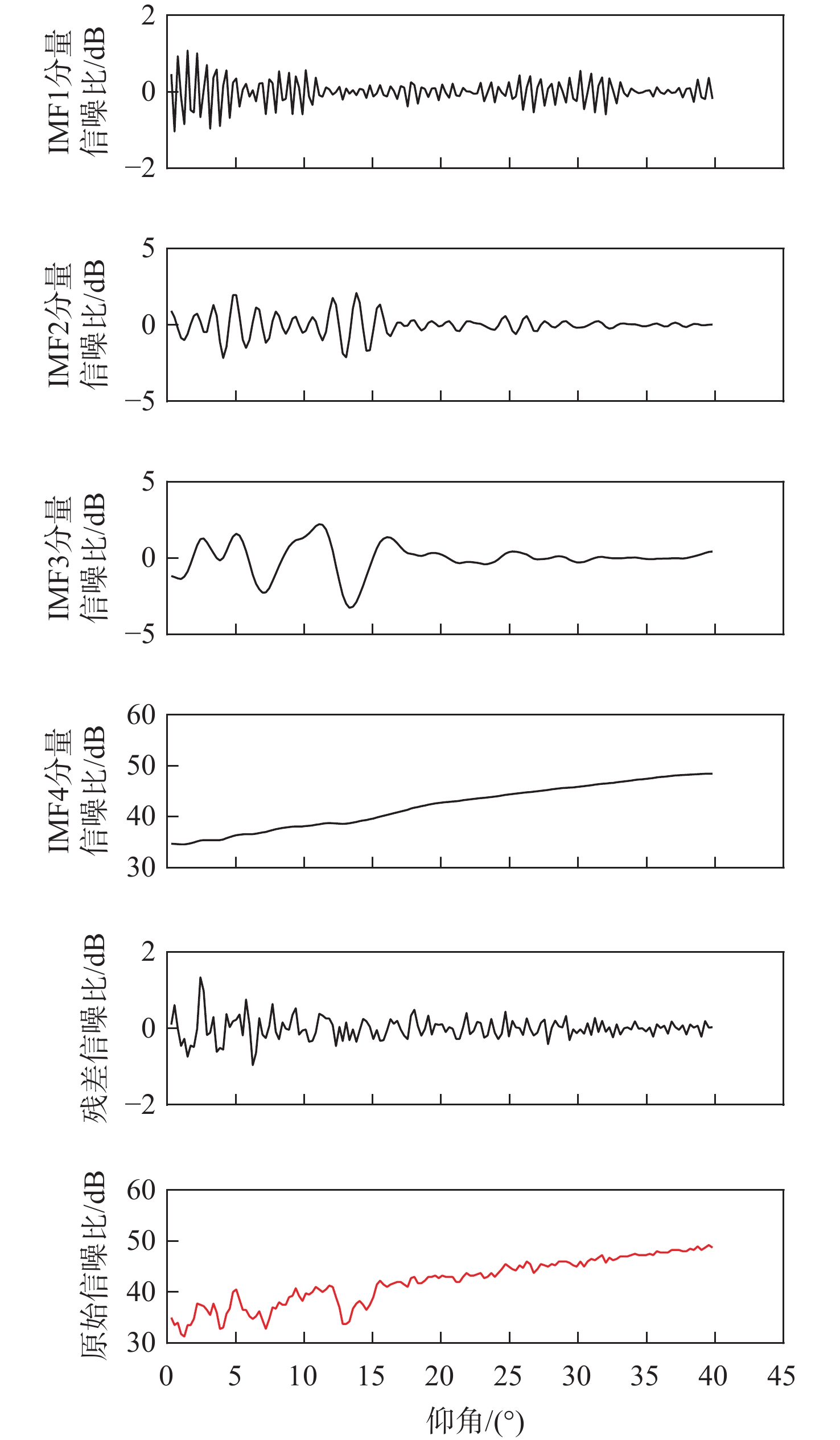
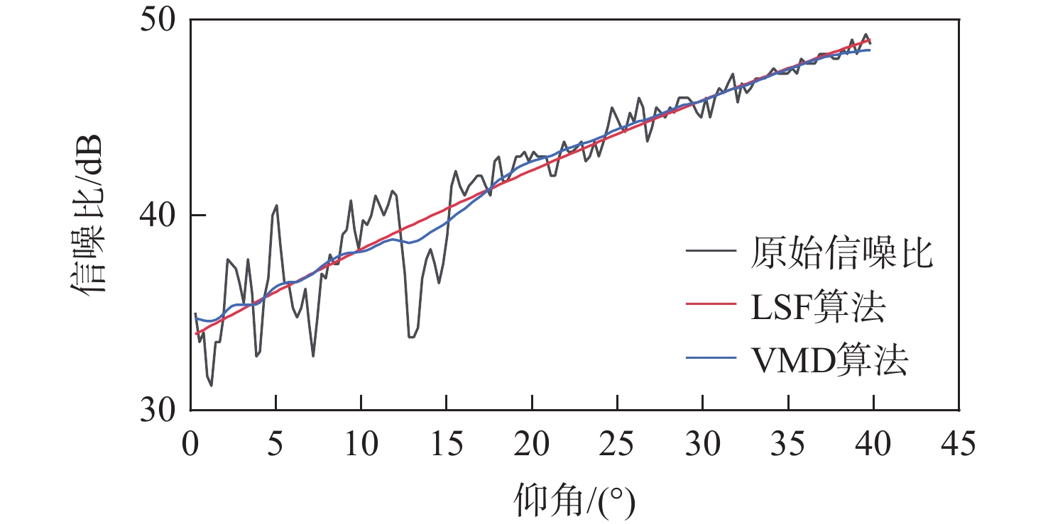
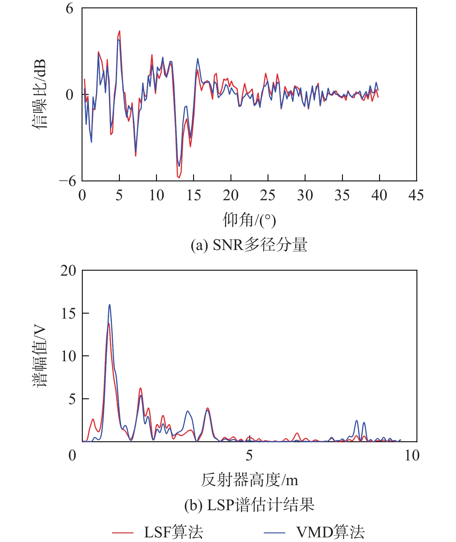
图 4 不同算法的SNR多径分量和LSP谱估计结果
Figure 4. SNR multipath components and LSP spectrum estimation results for different algorithms
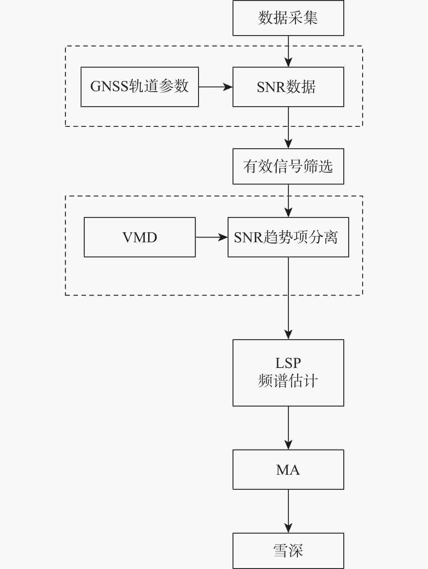
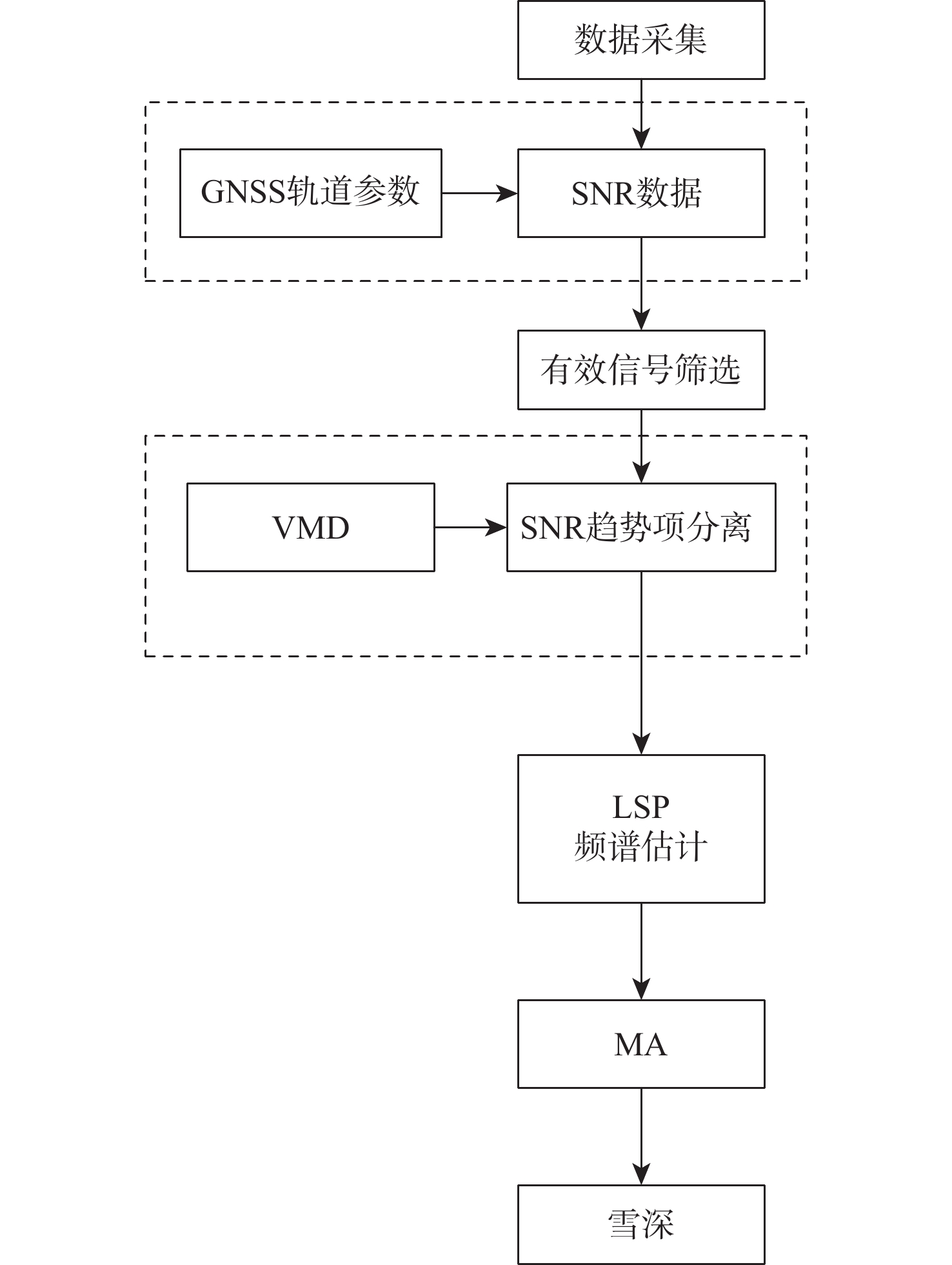
图 5 基于VMD-MA的GNSS-MR雪深反演模型
Figure 5. GNSS-MR snow depth inversion model based on VMD-MA
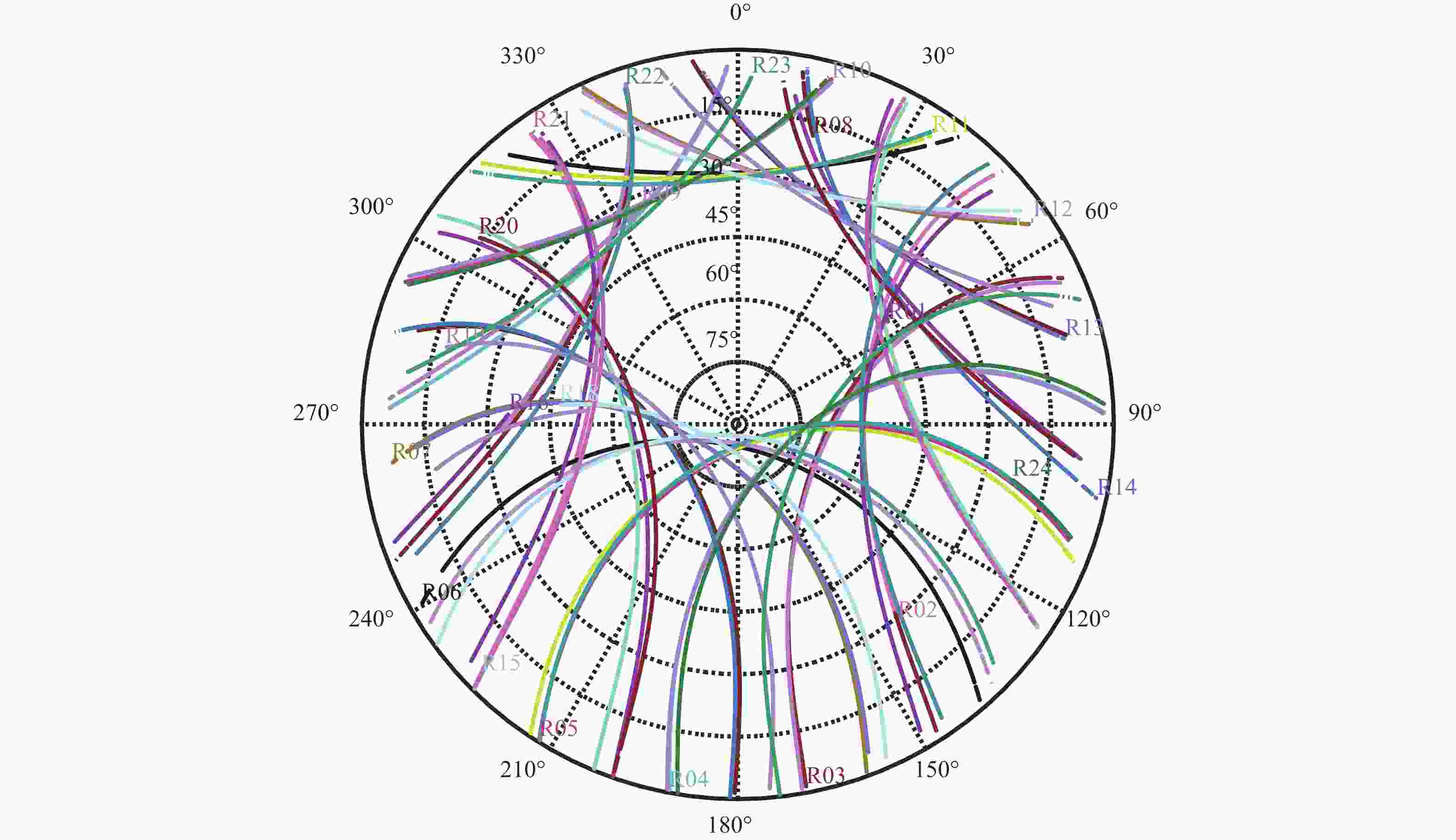
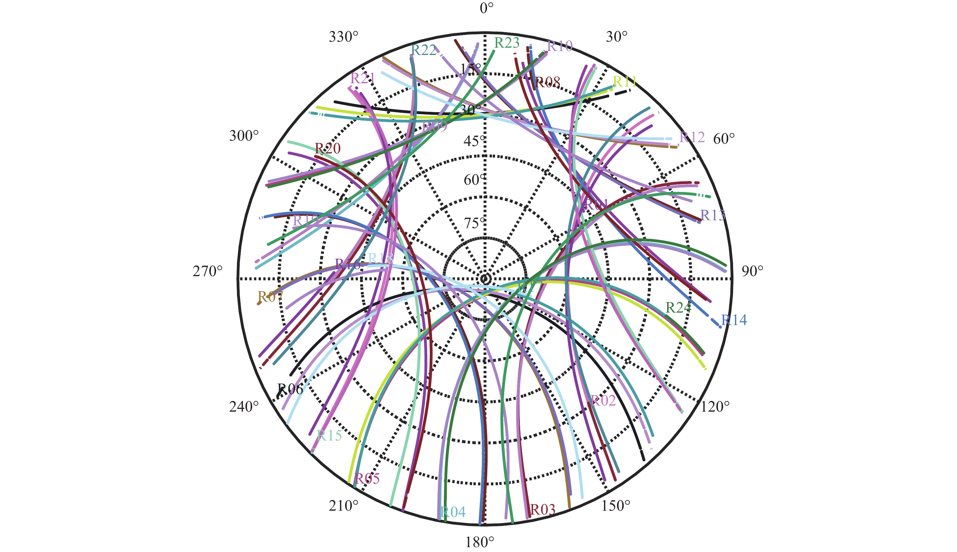
图 7 KIRU站2021年DOY 1的GLONASS卫星轨迹
Figure 7. Trajectories of GLONASS satellites of KIRU station on DOY 1, 2021

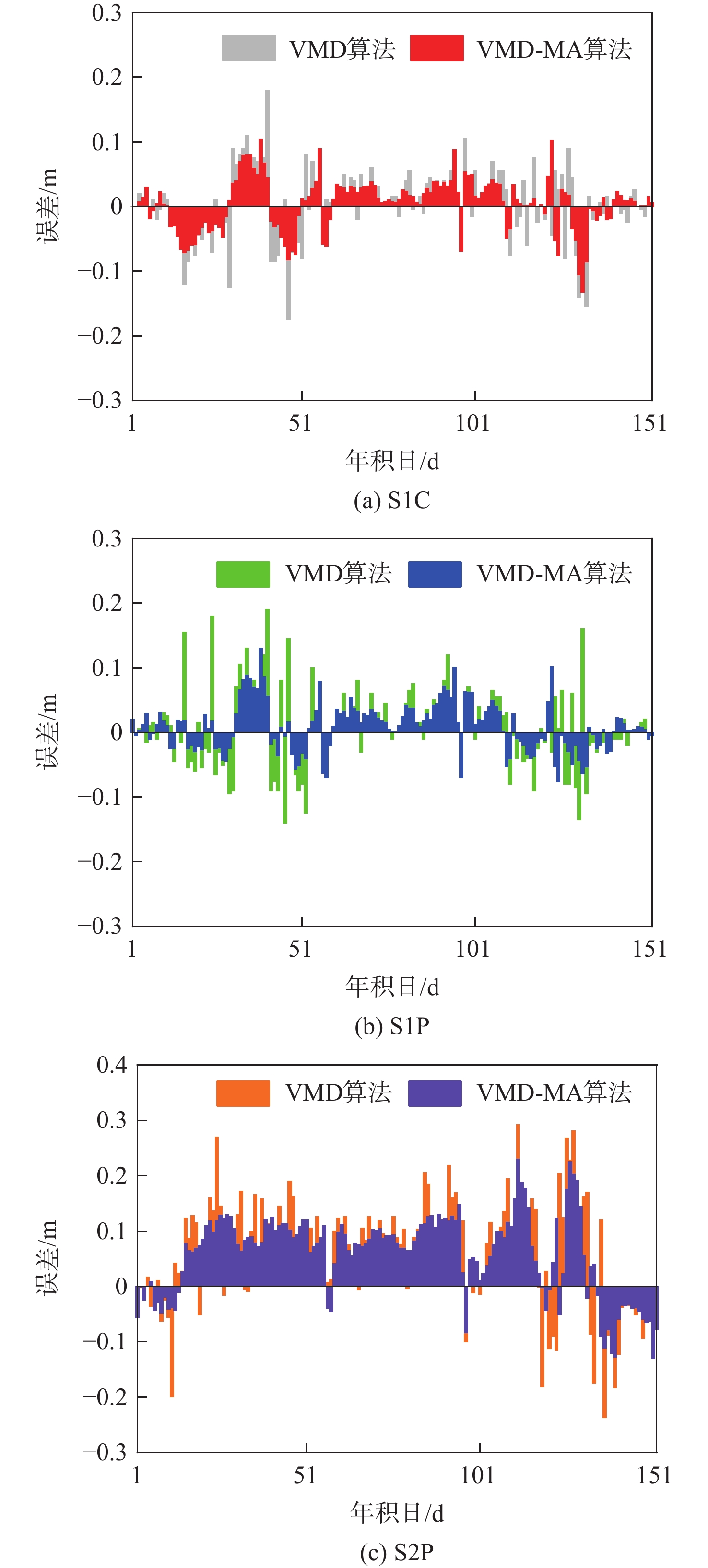
图 8 MA算法对各频段SNR观测值的误差平滑结果
Figure 8. Error smoothing results of MA algorithm for SNR data in various frequency bands

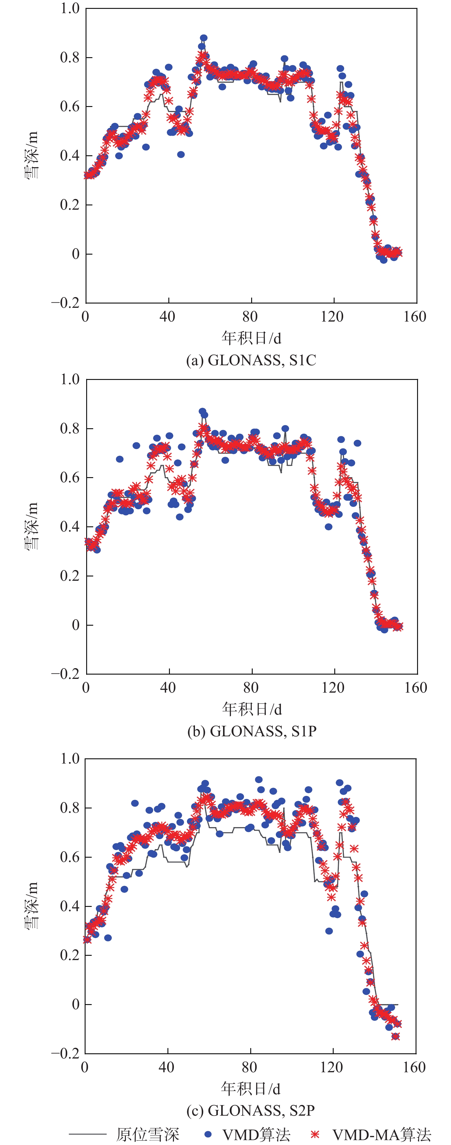
图 9 雪深反演结果与原位雪深的对比
Figure 9. Comparison of snow depth inversion results and in-situ snow depth
表 1 GLONASS 收集的SNR的频段、频率和通道/代码
Table 1. Frequency band, frequency, and channel/code of SNR types collected from GLONASS
频段 频率/MHz 通道/代码 SNR类型 G1 1602+9k/16 C/A S1C P S1P G2 1246+9k/16 P S2P  下载: 导出CSV
表 2 雪深反演结果评价比较
Table 2. Evaluation and comparison of snow depth inversion results
算法 平均绝对误差/cm 均方根误差/cm 相关系数 S1C S1P S2P S1C S1P S2P S1C S1P S2P 无平滑处理LSF算法 6.9 7.5 11.4 7.3 10.1 19.6 0.94 0.94 0.86 平滑处理LSF算法 4.2 7.4 11.0 4.8 10.0 19.4 0.98 0.95 0.89 无平滑处理VMD算法 5.2 5.9 9.9 5.2 6.0 11.5 0.97 0.97 0.95 平滑处理VMD算法 4.1 3.8 7.4 4.1 3.9 9.4 0.98 0.98 0.97
下载: 导出CSV
表 3 雪深反演结果评价比较(以GPS SNR为参考数据源)
Table 3. Evaluation and comparison of snow depth inversion results (taking GPS SNR as reference data source)
算法 平均绝对误差/cm 均方根误差/cm 相关系数 S1C S1P S2P S1C S1P S2P S1C S1P S2P 无平滑处理LSF算法 10.1 12.3 16.2 10.9 14.9 23.9 0.912 0.89 0.79 平滑处理LSF算法 8.6 12.2 15.8 9.5 14.8 23.7 0.95 0.9 0.83 无平滑处理VMD算法 6.6 7.6 10.1 6.7 7.6 10.9 0.96 0.95 0.93 平滑处理VMD算法 6.1 6.4 8.1 6.2 6.4 9.1 0.97 0.97 0.95
下载: 导出CSV
-
[1] WALSH J E. Snow cover and atmospheric variability: Changes in the snow covering the earth’s surface affect both daily weather and long-term climate[J]. American Scientist, 1984, 72(1): 50-57. [2] 胡媛, 袁鑫泰, 陈行杨, 等. 小波变换和改进Burg算法的GNSS-IR海面高度反演模型[J]. 大地测量与地球动力学, 2022, 42(1): 21-24.HU Y, YUAN X T, CHEN X Y, et al. GNSS-IR model of sea level inversion combining wavelet transform with improved Burg algorithm[J]. Journal of Geodesy and Geodynamics, 2022, 42(1): 21-24(in Chinese). [3] GEREMIA-NIEVINSKI F, HOBIGER T, HAAS R, et al. SNR-based GNSS reflectometry for coastal sea-level altimetry: Results from the first IAG inter-comparison campaign[J]. Journal of Geodesy, 2020, 94(8): 1-15. [4] LI Z, CHEN P, ZHENG N Q, et al. Accuracy analysis of GNSS-IR snow depth inversion algorithms[J]. Advances in Space Research, 2021, 67(4): 1317-1332. doi: 10.1016/j.asr.2020.11.021 [5] MARTIN-NEIRA M. A passive reflectometry and interferometry system (PARIS): Application to ocean altimetry[J]. ESA Journal, 1993, 17(4): 331-355. [6] BILICH A, LARSON K M, AXELRAD P. Observations of signal-to-noise ratios (SNR) at geodetic GPS site CASA: Implications for phase multipath[J]. Proceedings of the Centre for European Geodynamics and Seismology, 2004, 23: 77-83. [7] LARSON K M, GUTMANN E D, ZAVOROTNY V U, et al. Can we measure snow depth with GPS receivers?[J]. Geophysical Research Letters, 2009, 36(17): L17502-L17506. doi: 10.1029/2009GL039430 [8] NIEVINSKI F G, LARSON K M. Forward modeling of GPS multipath for near-surface reflectometry and positioning applications[J]. GPS Solutions, 2014, 18(2): 309-322. doi: 10.1007/s10291-013-0331-y [9] LARSON K M, NIEVINSKI F G. GPS snow sensing: Results from the earthscope plate boundary observatory[J]. GPS Solutions, 2013, 17(1): 41-52. doi: 10.1007/s10291-012-0259-7 [10] TABIBI S, NIEVINSKI F G, VAN DAM T, et al. Assessment of modernized GPS L5 SNR for ground-based multipath reflectometry applications[J]. Advances in Space Research, 2015, 55(4): 1104-1116. doi: 10.1016/j.asr.2014.11.019 [11] JIN S, QIAN X, KUTOGLU H. Snow depth variations estimated from GPS-reflectometry: A case study in Alaska from L2P SNR data[J]. Remote Sensing, 2016, 8(1): 63-77. doi: 10.3390/rs8010063 [12] TABIBI S, GEREMIA-NIEVINSKI F, VAN DAM T. Statistical comparison and combination of GPS, GLONASS, and multi-GNSS multipath reflectometry applied to snow depth retrieval[J]. IEEE Transactions on Geoscience and Remote Sensing, 2017, 55(7): 3773-3785. doi: 10.1109/TGRS.2017.2679899 [13] DYER S A, HE X. Least-squares fitting of data by polynomials[J]. IEEE Instrumentation & Measurement Magazine, 2001, 4(4): 46-51. [14] HU Y, YUAN X T, LIU W, et al. GNSS-IR model of sea level height estimation combining variational mode decomposition[J]. IEEE Journal of Selected Topics in Applied Earth Observations and Remote Sensing, 2021, 14: 10405-10414. doi: 10.1109/JSTARS.2021.3118398 [15] DRAGOMIRETSKIY K, ZOSSO D. Variational mode decomposition[J]. IEEE Transactions on Signal Processing, 2013, 62(3): 531-544. [16] 吴文轩, 王志坚, 张纪平, 等. 基于峭度的VMD分解中k值的确定方法研究[J]. 机械传动, 2018, 42(8): 153-157.WU W X, WANG Z J, ZHANG J P, et al. Research of the method of determining k value in VMD based on kurtosis[J]. Journal of Mechanical Transmission, 2018, 42(8): 153-157(in Chinese). [17] WILLIAMS S, NIEVINSKI F. Tropospheric delays in ground-based GNSS multipath reflectometry—Experimental evidence from coastal sites[J]. Journal of Geophysical Research:Solid Earth, 2017, 122(3): 2310-2327. doi: 10.1002/2016JB013612 [18] ROUSSEL N, RAMILLIEN G, FRAPPART F, et al. Sea level monitoring and sea state estimate using a single geodetic receiver[J]. Remote Sensing of Environment, 2015, 171: 261-277. doi: 10.1016/j.rse.2015.10.011 [19] LI F, LIU L, HUANG L, et al. GNSS snow depth monitoring using SNR observations[C]//Proceedings of the China Satellite Navigation Conference. Berlin: Springer, 2019: 211-219. -

 下载:
下载:

 点击查看大图
计量
- 文章访问数: 159
- HTML全文浏览量: 47
- PDF下载量: 25
- 被引次数: 0
