


-
摘要:
星载GNSS反射信号(GNSS-R)的土壤湿度反演易受陆地多变环境因素影响,目前,对于星载GNSS-R土壤湿度反演中误差分析及反演模型外推性能分析较少。综合多种误差修正模型,包括GNSS卫星发射功率误差、植被和地表粗糙度对反射信号强度的衰减,通过修正提高陆地点反射率的准确性,建立了反射率-土壤湿度的CYGNSS/SMAP数据融合的反演半经验模型。实现了一年高精度外推反演,反演偏差为−0.0037 cm3/cm3,均方根误差(RMSE)为0.0264 cm3/cm3,相关系数为0.9636。提出了分季节的外推模型,提高了低含水量季节的外推精度。实验区域的经度为90°E~130°E,纬度为20°N~38°N,利用2019年10月至2020年9月的CYGNSS/SMAP数据进行训练,外推2020年10月至2021年9月的土壤湿度。经误差模型修正反射率后,模型的反演偏差提升6.80%,均方根误差提升3.30%。针对实验区域内冬、春季土壤含水量较低时反演精度差的问题,提出了同季节外推的分季节训练模型,相对一年数据量的训练模型,冬季反演的均方根误差提升21.58%,春季提升21.05%。将2021年6月1—10日的反演结果与CLDAS地面实测土壤湿度进行对比,反演偏差为0.0058 cm3/cm3,均方根误差为0.0854 cm3/cm3,具有较好的准确性。研究证明了使用反射率误差修正模型及反射率-土壤湿度半经验模型反演土壤湿度的有效性,对推广星载GNSS-R土壤湿度反演业务化应用具有积极意义。
Abstract:Soil moisture retrieval of the satellite-borne GNSS reflected signal (GNSS-R) is more susceptible to the influence of the changing environmental factors on the land. At present, there is little research on error correction and extrapolation performance analysis in the satellite-borne GNSS-R soil moisture retrieval model. The accuracy of the reflectivity of land points is enhanced by correction in this article, which synthesizes a number of error correction models, including the GNSS satellite transmit power deviation, the attenuation of the reflected signal strength by vegetation and surface roughness, and these factors. A semi-empirical retrieval model of CYGNSS/SMAP data fusion of reflectance-soil moisture was established. One-year high-precision extrapolation retrieval is achieved, retrieval bias is −0.0037 cm3/cm3, the root mean square error (RMSE) is 0.0264 cm3/cm3 and the correlation coefficient is 0.963 6. At the same time, a seasonal extrapolation model is proposed to improve the extrapolation accuracy in low water content seasons. The longitude of the experimental area is 90°E−130°E, the latitude is 20°N−38°N, and the CYGNSS/SMAP data from October 2019 to September 2020 are used for training. Push the soil moisture from October 2020 to September 2021. After the reflectivity is corrected by the error model, the semi-empirical model retrieval bias is improved by 6.80%, and and RMSE is improved by 3.30%. Aiming at the problem that the winter and spring soil moisture content low in the experimental area affects the retrieval accuracy, proposes a seasonal training model for extrapolation in the same season,compared with the training model with one-year data volume, the RMSE of winter retrieval can be increased by 21.58%, and the spring can be increased by 21.05%. Comparing the retrieval results from June 1 to 10, 2021 with the soil moisture measured on the ground by CLDAS, the Bias is 0.0058 cm3/cm3 and the RMSE is 0.0854 cm3/cm3, which can maintain good accuracy. This paper’s research results have proved the effectiveness of using the reflectivity-soil moisture semi-empirical model and the reflectivity error correction, which are of significance for the promotion of the commercial application of the on-board GNSS-R soil moisture retrieval.
-
Key words:
- GNSS reflected signal /
- soil moisture /
- CYGNSS /
- SMAP /
- vegetation attenuation /
- soil surface rough
-

图 1 GNSS-R土壤湿度反演原理示意图
Figure 1. Schematic diagram of GNSS-R soil moisture retrieval principle

图 6 半经验模型的土壤湿度反演流程
Figure 6. Flowchart of soil moisture retrieval from semi-empirical model

图 7 反演结果的密度散点图(2020年10月至2021年9月)
Figure 7. Density scatter plot of inversion results (2020-10—2021-09)

图 8 实验地区部分区域反演的土壤湿度(2020年10月至2021年9月)
Figure 8. Soil moisture retrieved in part of experimental area (2020-10—2021-09)
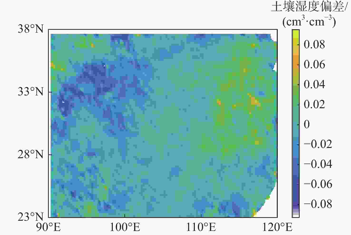
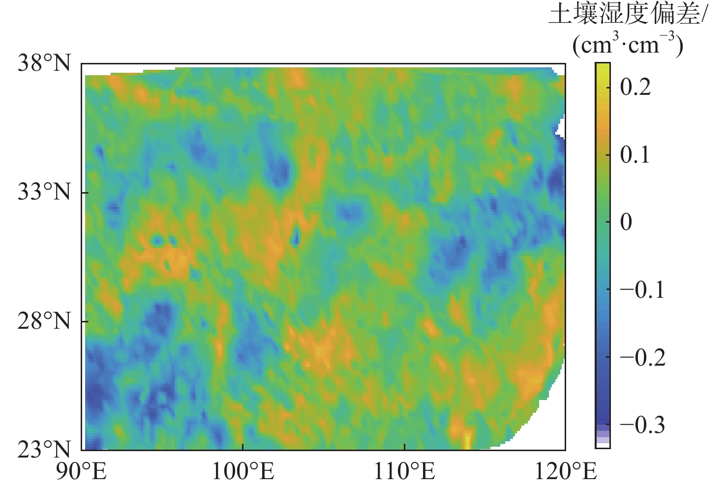
图 9 实验地区部分区域土壤湿度偏差(2020年10月至2021年9月)
Figure 9. Soil moisture deviation in part of experimental area(2020-10—2021-09)

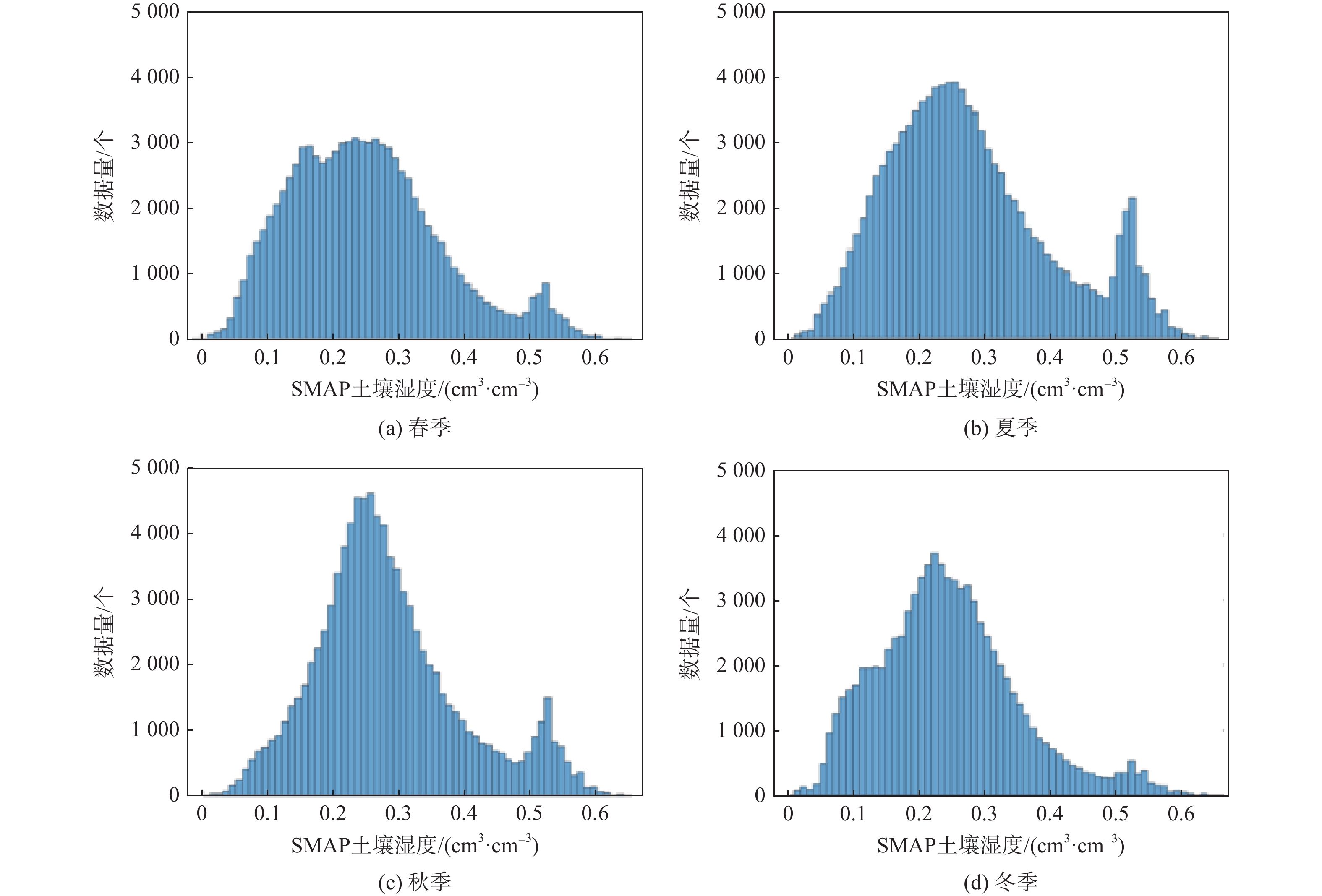
图 10 土壤湿度的数量分布(实验地区部分区域)
Figure 10. Number distribution of soil moisture (part of experiment area)

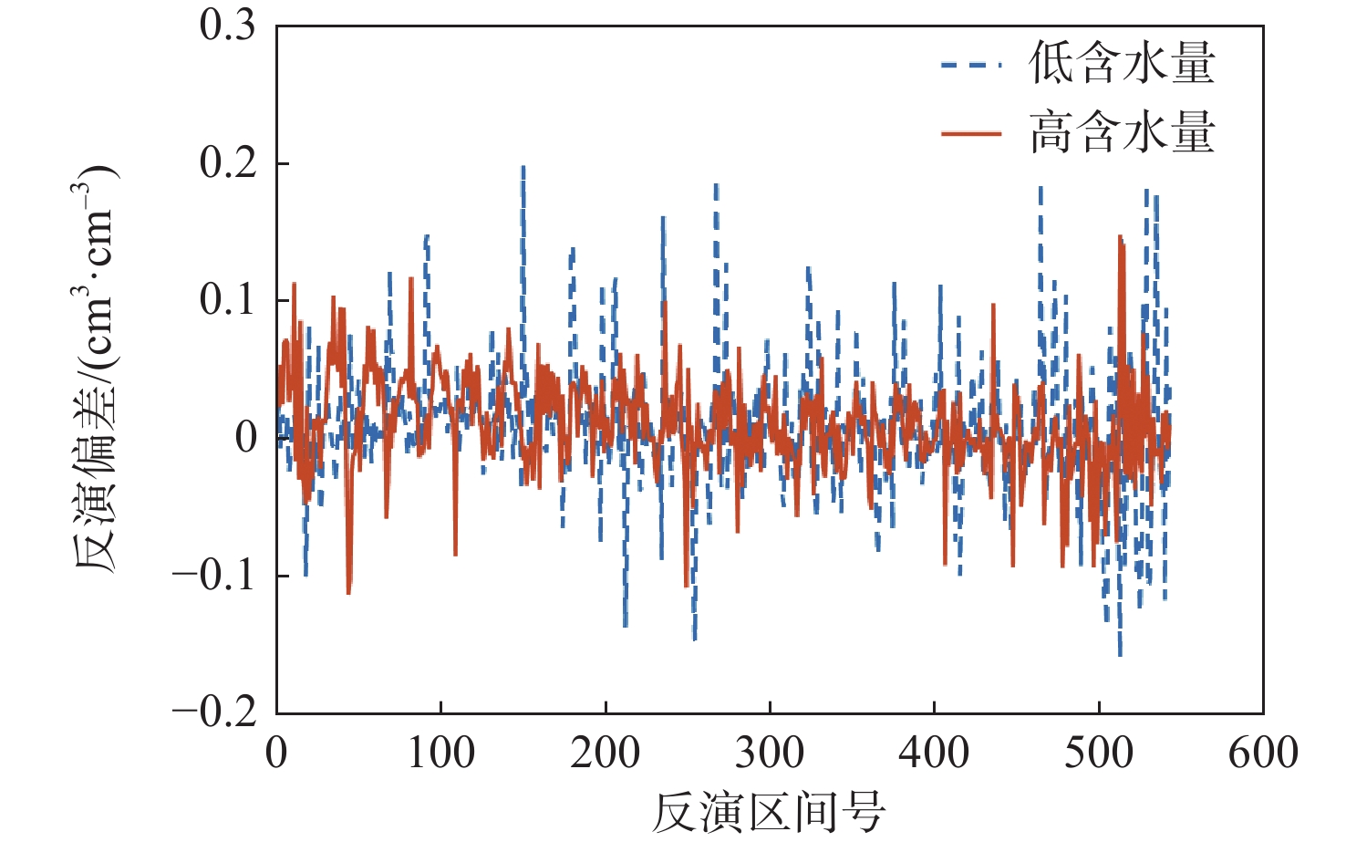
图 11 高、低含水量反演的偏差结果
Figure 11. Bias results of retrieval of high and low water content inversions

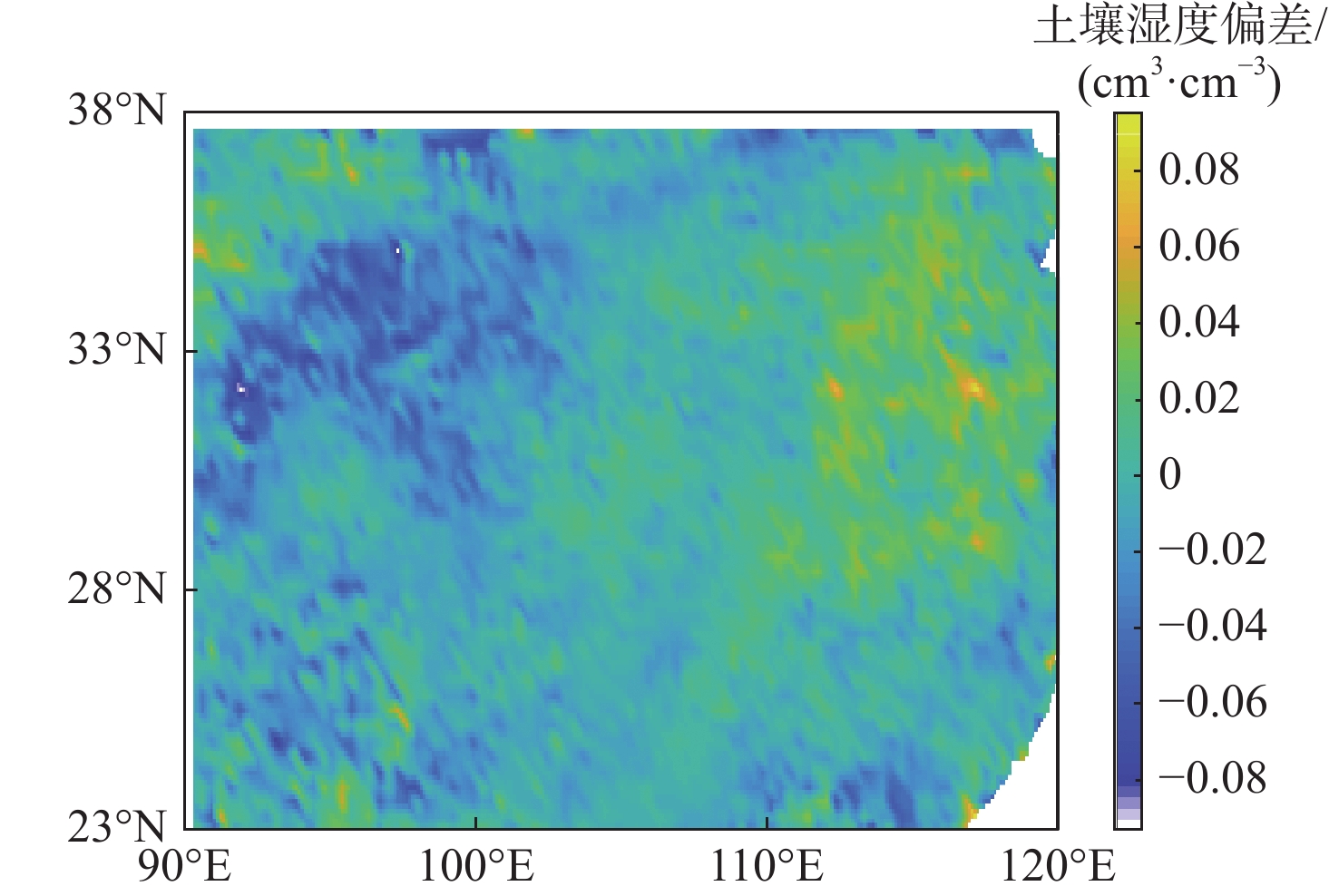
图 12 实验地区部分区域CLDAS数据对比的土壤湿度偏差(2021年6月1—10日)
Figure 12. Soil moisture bias for CLDAS data comparison in part of experimental area (June 1−10, 2021)
表 1 32颗GPS卫星对应的反射率误差
Table 1. Reflectivity error of 32 GPS satellites
dB PRN 反射率误差 PRN 反射率误差 1 0.0025 17 −1.4289 2 1.0983 18 0.0422 3 0.7797 19 −0.0992 4 −1.0832 20 2.3085 5 −0.8721 21 0.6661 6 0.4789 22 0.5552 7 −1.3485 23 0.8808 8 0.5355 24 0.5584 9 0.5076 25 −0.1033 10 1.6219 26 0.1490 11 1.0035 27 0.5271 12 −1.3877 28 0.9964 13 1.4203 29 −1.4678 14 0.1841 30 0.6120 15 −0.7908 31 −1.3264 16 0.5409 32 −0.1931  下载: 导出CSV
表 2 误差修正前后反演结果
Table 2. Retrieval results before and after error correction
cm3/cm3 训练数据月份 反演月份 反演偏差 均方根误差 未修正各类误差 修正各类误差 未修正各类误差 修正各类误差 2020年1—9月 2020年10月 −0.0097 0.0600 0.0096 0.0593 2020年11月 −0.0307 0.0666 −0.0297 0.0653 2020年12月 −0.0448 0.0662 −0.0429 0.0642 2021年1月 −0.0603 0.0759 −0.0562 0.0734
下载: 导出CSV
表 3 不同训练集数据量的模型反演结果
Table 3. Retrieval results of models with different amounts of training data
训练数据
月份训练模型
数据量/个反演月份
(单个月)反演偏差/
(cm3·cm−3)均方根误差/
(cm3·cm−3)2020年
7—9月102855 2020年10月 −0.0336 0.0705 2020年11月 −0.0550 0.0844 2020年12月 −0.0699 0.0951 2021年1月 −0.0826 0.1049 训练数据
月份训练模型
数据量/个反演月份
(单个月)反演偏差/
(cm3·cm−3)均方根误差/
(cm3·cm−3)2020年
1—9月273047 2020年10月 0.0096 0.0593 2020年11月 −0.0297 0.0653 2020年12月 −0.0429 0.0642 2021年1月 −0.0562 0.0734 训练数据
月份训练模型
数据量/个反演月份
(单个月)反演偏差/
(cm3·cm−3)均方根误差/
(cm3·cm−3)2019年10月至
2020年9月356966 2020年10月 −0.0018 0.0561 2020年11月 −0.0217 0.0589 2020年12月 −0.0345 0.0572 2021年1月 −0.0477 0.0655
下载: 导出CSV
表 4 一年训练集数据量的模型反演结果
Table 4. Retrieval results of model for one year training data
cm3/cm3 训练数据月份 反演月份
(单个月)反演偏差 均方根误差 2019年10月至
2020年9月2020年10月 −0.0018 0.0561 2020年11月 −0.0217 0.0589 2020年12月 −0.0345 0.0572 2021年1月 −0.0477 0.0655 2021年2月 −0.0293 0.0594 2021年3月 −0.0283 0.0698 2021年4月 −0.0164 0.0635 2021年5月 −0.0014 0.0593 2021年6月 0.0235 0.0562 2021年7月 0.0283 0.0596 2021年8月 0.0295 0.0599 2021年9月 0.0229 0.0595
下载: 导出CSV
表 5 按季节分类的土壤湿度反演结果
Table 5. Retrieval results of soil moisture classified by season
cm3/cm3 训练数据
月份反演月份 反演偏差 均方根误差 2019年11月—
2020年1月
(冬季)2020年11月 0.0215 0.0503 2020年12月 −0.0019 0.0445 2021年1月 −0.0148 0.0472 2020年2—
4月
(春季)2021年2月 −0.0142 0.0496 2021年3月 −0.0107 0.0491 2021年4月 0.0060 0.0527
下载: 导出CSV
-
[1] 涂晋升. 利用GNSS-R观测数据反演土壤湿度[D]. 成都: 西南交通大学, 2019: 1-2.TU J S. Soil moisture retrieve using GNSS-R observation data[D]. Chengdu: Southwest Jiaotong University, 2019: 1-2(in Chinese). [2] 赵霞, 陈赛楠. SMAP卫星土壤水分产品对比研究与误差分析[J]. 甘肃科学学报, 2021, 33(2): 27-32. doi: 10.16468/j.cnki.issn1004-0366.2021.02.005ZHAO X, CHEN S N. Comparative study and error analysis of soil moisture products from SMAP satellite[J]. Journal of Gansu Sciences, 2021, 33(2): 27-32(in Chinese). doi: 10.16468/j.cnki.issn1004-0366.2021.02.005 [3] KERR Y H, WALDTEUFEL P, WIGNERON J P, et al. Soil moisture retrieval from space: The soil moisture and ocean salinity (SMOS) mission[J]. IEEE Transactions on Geoscience and Remote Sensing, 2001, 39(8): 1729-1735. doi: 10.1109/36.942551 [4] ENTEKHABI D, NJOKU E G, O’NEILL P E, et al. The soil moisture active passive (SMAP) mission[J]. Proceedings of the IEEE, 2010, 98(5): 704-716. doi: 10.1109/JPROC.2010.2043918 [5] 杭斯加, 张云, 李彬彬, 等. 岸基北斗IGSO卫星反射信号相位测高[J]. 遥感信息, 2020, 35(1): 73-81.HANG S J, ZHANG Y, LI B B, et al. Feasibility of coastal phase altimetry using BeiDou IGSO satellite reflected signal[J]. Remote Sensing Information, 2020, 35(1): 73-81(in Chinese). [6] 张云, 张杨阳, 孟婉婷, 等. 机载GNSS反射信号海面测高模型的研究[J]. 海洋学报, 2020, 42(3): 149-156.ZHANG Y, ZHANG Y Y, MENG W T, et al. Research on sea surface altimetry model of airborne GNSS reflected signal[J]. Haiyang Xuebao, 2020, 42(3): 149-156(in Chinese). [7] 张云, 马德皓, 孟婉婷, 等. 基于TechDemoSat-1卫星的GPS反射信号海面高度反演[J]. 北京航空航天大学学报, 2021, 47(10): 1941-1948. doi: 10.13700/j.bh.1001-5965.2020.0357ZHANG Y, MA D H, MENG W T, et al. Sea surface height retrieval of GPS reflected signal based on TechDemoSat-1 satellite[J]. Journal of Beijing University of Aeronautics and Astronautics, 2021, 47(10): 1941-1948(in Chinese). doi: 10.13700/j.bh.1001-5965.2020.0357 [8] ZHANG Y, CHEN X, MENG W T, et al. Wind direction retrieval using support vector machine from CYGNSS sea surface data[J]. Remote Sensing, 2021, 13(21): 4451. doi: 10.3390/rs13214451 [9] CHEW C C, SHAH R, ZUFFADA C, et al. Demonstrating soil moisture remote sensing with observations from the UK TechDemoSat-1 satellite mission[J]. Geophysical Research Letters, 2016, 43(7): 3317-3324. doi: 10.1002/2016GL068189 [10] CHEW C C, SMALL E E. Soil moisture sensing using spaceborne GNSS reflections: Comparison of CYGNSS reflectivity to SMAP soil moisture[J]. Geophysical Research Letters, 2018, 45(9): 4049-4057. doi: 10.1029/2018GL077905 [11] CLARIZIA M P, PIERDICCA N, COSTANTINI F, et al. Analysis of CYGNSS data for soil moisture retrieval[J]. IEEE Journal of Selected Topics in Applied Earth Observations and Remote Sensing, 2019, 12(7): 2227-2235. doi: 10.1109/JSTARS.2019.2895510 [12] WAN W, JI R, LIU B J, et al. A two-step method to calibrate CYGNSS-derived land surface reflectivity for accurate soil moisture estimations[J]. IEEE Geoscience and Remote Sensing Letters, 2020, 19: 2500405. [13] CHEW C C, SMALL E E. Description of the UCAR/CU soil moisture product[J]. Remote Sensing, 2020, 12(10): 1588. doi: 10.3390/rs12101588 [14] 杨文涛, 徐天河, 王娜子, 等. 星载GNSS-R土壤湿度反演中开放水域的影响[J]. 北京航空航天大学学报, 2023, 49(7): 1779-1786. doi: 10.13700/j.bh.1001-5965.2021.0479YANG W T, XU T H, WANG N Z, et al. Influence of open water in retrieval of soil moisture by spaceborne GNSS-R[J]. Journal of Beijing University of Aeronautics and Astronautics, 2023, 49(7): 1779-1786(in Chinese). doi: 10.13700/j.bh.1001-5965.2021.0479 [15] RUF C, ASHARAF S, BALASUBRAMANIAM R, et al. In-orbit performance of the constellation of CYGNSS hurricane satellites[J]. Bulletin of the American Meteorological Society, 2019, 100(10): 2009-2023. doi: 10.1175/BAMS-D-18-0337.1 [16] O’NEILLE P, CHAN S, NJOKU E G, et al. SMAP L3 radiometer global daily 36 km EASE-grid soil moisture, Version7[EB/OL]. [2021-12-23]. https://doi.org/10.5067/HH4SZ2PXSP6A. [17] 韩帅, 师春香, 姜立鹏, 等. CLDAS 土壤湿度模拟结果及评估[J]. 应用气象学报, 2017, 28(3): 369-378.HAN S, SHI C X, JIANG L P, et al. The simulation and evaluation of soil moisture based on CLDAS[J]. Journal of Applied Meteorological Science, 2017, 28(3): 369-378(in Chinese). [18] STILLA D, ZRIBI M, PIERDICCA N, et al. Desert roughness retrieval using CYGNSS GNSS-R data[J]. Remote Sensing, 2020, 12(4): 743. doi: 10.3390/rs12040743 [19] AL-KHALDI M M, JOHNSON J T, O’BRIEN A J, et al. Time-series retrieval of soil moisture using CYGNSS[J]. IEEE Transactions on Geoscience and Remote Sensing, 2019, 57(7): 4322-4331. doi: 10.1109/TGRS.2019.2923175 [20] DONG Z N, JIN S G. Evaluation of the land GNSS-reflected DDM coherence on soil moisture estimation from CYGNSS data[J]. Remote Sensing, 2021, 13(4): 570. doi: 10.3390/rs13040570 [21] BINDLISH R, BARROS A P. Parameterization of vegetation backscatter in radar-based, soil moisture estimation[J]. Remote Sensing of Environment, 2001, 76(1): 130-137. doi: 10.1016/S0034-4257(00)00200-5 [22] CHOUDHURYB J, SCHMUGGE T J, CHANG A, et al. Effect of surface roughness on the microwave emission from soils[J]. Journal of Geophysical Research:Oceans, 1979, 84(C9): 5699-5706. doi: 10.1029/JC084iC09p05699 [23] ZENG J Y, CHEN K S, BI H Y, et al. A preliminary evaluation of the SMAP radiometer soil moisture product over United States and Europe using ground-based measurements[J]. IEEE Transactions on Geoscience and Remote Sensing, 2016, 54(8): 4929-4940. doi: 10.1109/TGRS.2016.2553085 -

 下载:
下载:


 点击查看大图

计量
- 文章访问数: 372
- HTML全文浏览量: 548
- PDF下载量: 90
- 被引次数: 0
