


Soil moisture algorithm testing of interference signal inversion with GNSS linearly polarized antenna
-
摘要:
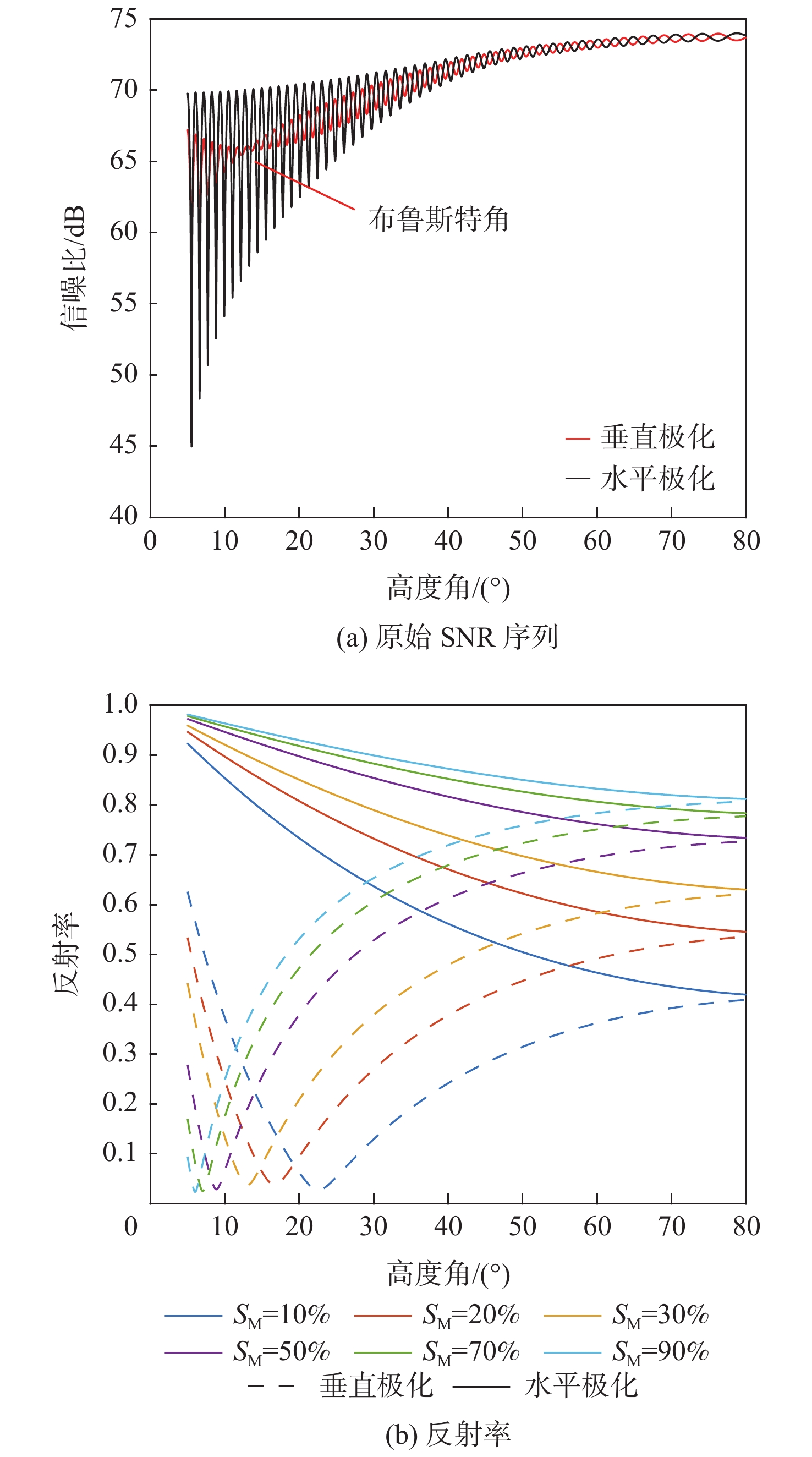
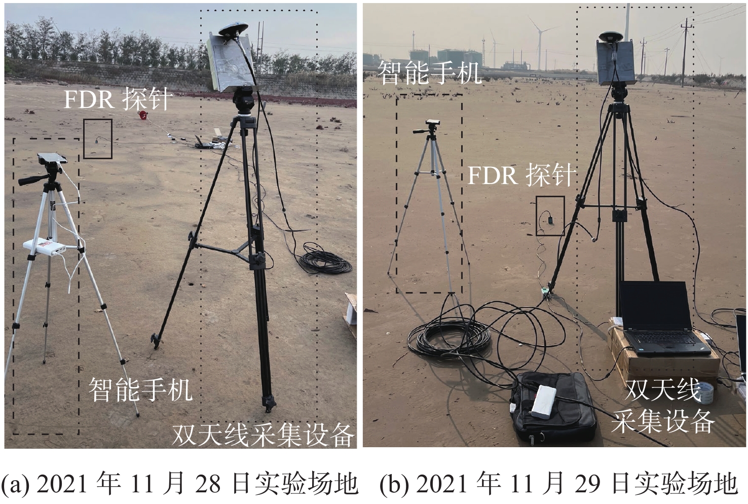
利用全球导航卫星系统干涉信号(GNSS-IR)测量土壤湿度已成为热门的研究课题。搭载低成本线性极化天线的智能手机可以方便快捷采集干涉信号信噪比(SNR)。分别仿真垂直和水平线性极化天线采集的GNSS干涉信号,给出2种极化方式下干涉信号SNR波形和反射率随卫星高度角变化的结果。对于垂直极化分量,电磁波会在入射角65°~85°左右时发生全透射,导致干涉信号振荡效果消失,而水平极化不存在该现象。同时,分别仿真右旋圆极化(RHCP)直射和左旋圆极化(LHCP)反射天线采集的GNSS信号,并计算直反射信号的幅值比。在仿真基础上分别利用不同极化天线进行实验,结果表明:采用线性极化天线采集的GNSS干涉信号振荡效果几乎不受卫星高度角的限制,可以为土壤湿度反演提供更多的有效数据,并且反演得到的土壤湿度与同位数据具有良好的一致性,两者的相关性达到0.95。使用搭载圆极化天线的双通道接收机采集北斗系统卫星数据进行对比,相关性达到0.91。对于不同的设备,智能手机采集的GNSS数据占用空间相对比于双通道接收机降低1%,且反演结果相关性接近,由于干涉信号提取直反射信号需要一定的振荡周期,故反演结果的时间分辨率要低于双通道接收机。
-
关键词:
- 全球导航卫星系统干涉信号 /
- 线性极化 /
- 信号幅值比 /
- 土壤湿度 /
- 圆极化
Abstract:Using global navigation satellite system Interferometric reflectometry (GNSS-IR) to measure soil moisture has become a prominent research topic. Smartphones equipped with low-cost linearly polarized antennas can easily and quickly acquire the signal noise ratio (SNR) of interference signals. The GNSS interference signals collected by the vertical and horizontal linearly polarized antennas are simulated separately, with the results of the SNR waveform and reflectivity of the interference signals changing with the satellite altitude angle under the two polarization modes. For the vertically polarized component, the electromagnetic wave is totally transmitted at the incident angle of about 65~85°, resulting in the disappearance of the oscillation effect of the interference signal. However, this phenomenon does not exist in the horizontal polarization. Then, the GNSS signals collected by the right-handed circle polarized (RHCP) direct and left-handed circle polarized (LHCP) reflective antennas are simulated separately, and the amplitude ratio of the direct reflection signal is calculated. Based on the simulation, experiments were carried out with different polarized antennas. Results show that the oscillation effect of the GNSS interference signal collected by the linearly polarized antenna is barely limited by the satellite altitude angle, providing more effective data for soil moisture inversion. The soil moisture obtained by the inversion is in good agreement with that of the isotopic data, and their correlation reaches 0.95. A dual-channel receiver equipped with a circularly polarized antenna is used to collect Beidou satellite data for comparison, revealing a correlation of 0.91. For different devices, the occupied space of the GNSS data collected by the smartphone is reduced to 1% compared with that of the dual-channel receiver, and the correlation of the inversion results is close. Since the interference signal needs a certain oscillation period to extract the direct reflection signal, the inversion results show a lower time resolution than that of a dual-channel receiver.
-
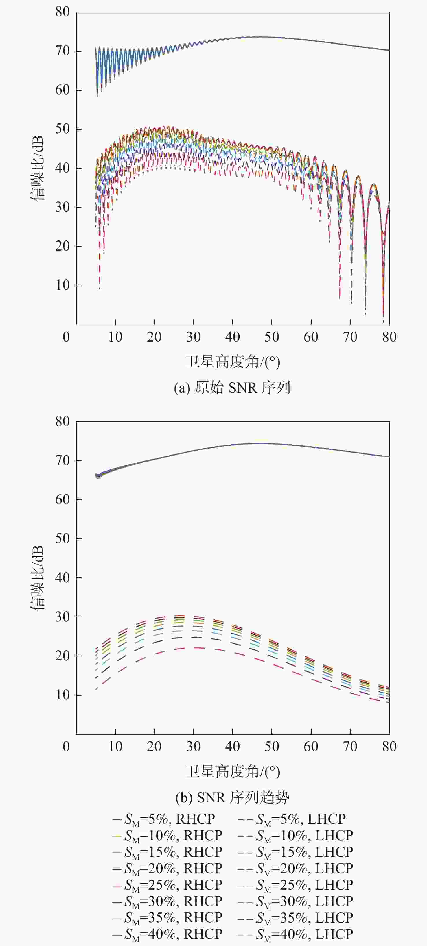
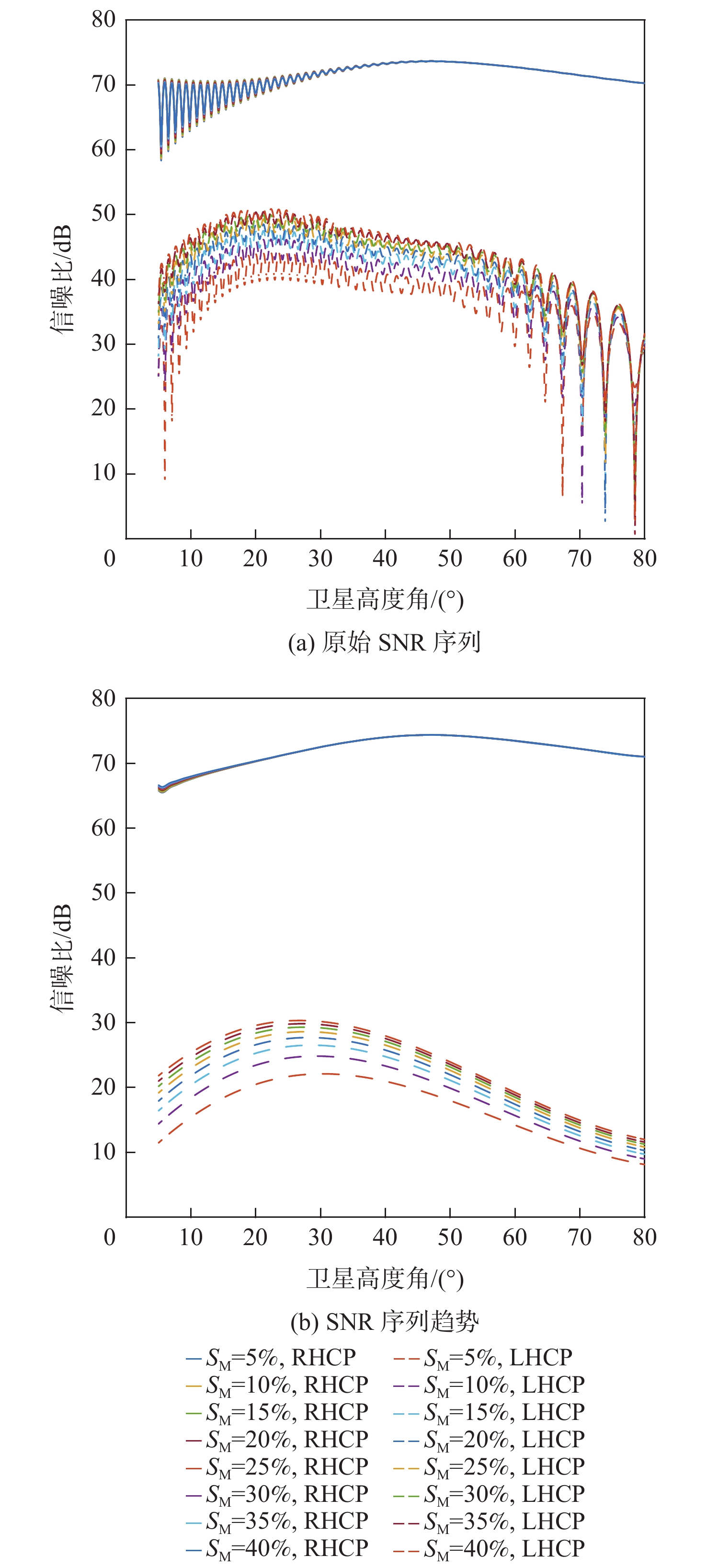
图 3 MEO 卫星直反射信号原始 SNR 和趋势
Figure 3. Original SNR and its trend of direct reflection signal from MEO satellite
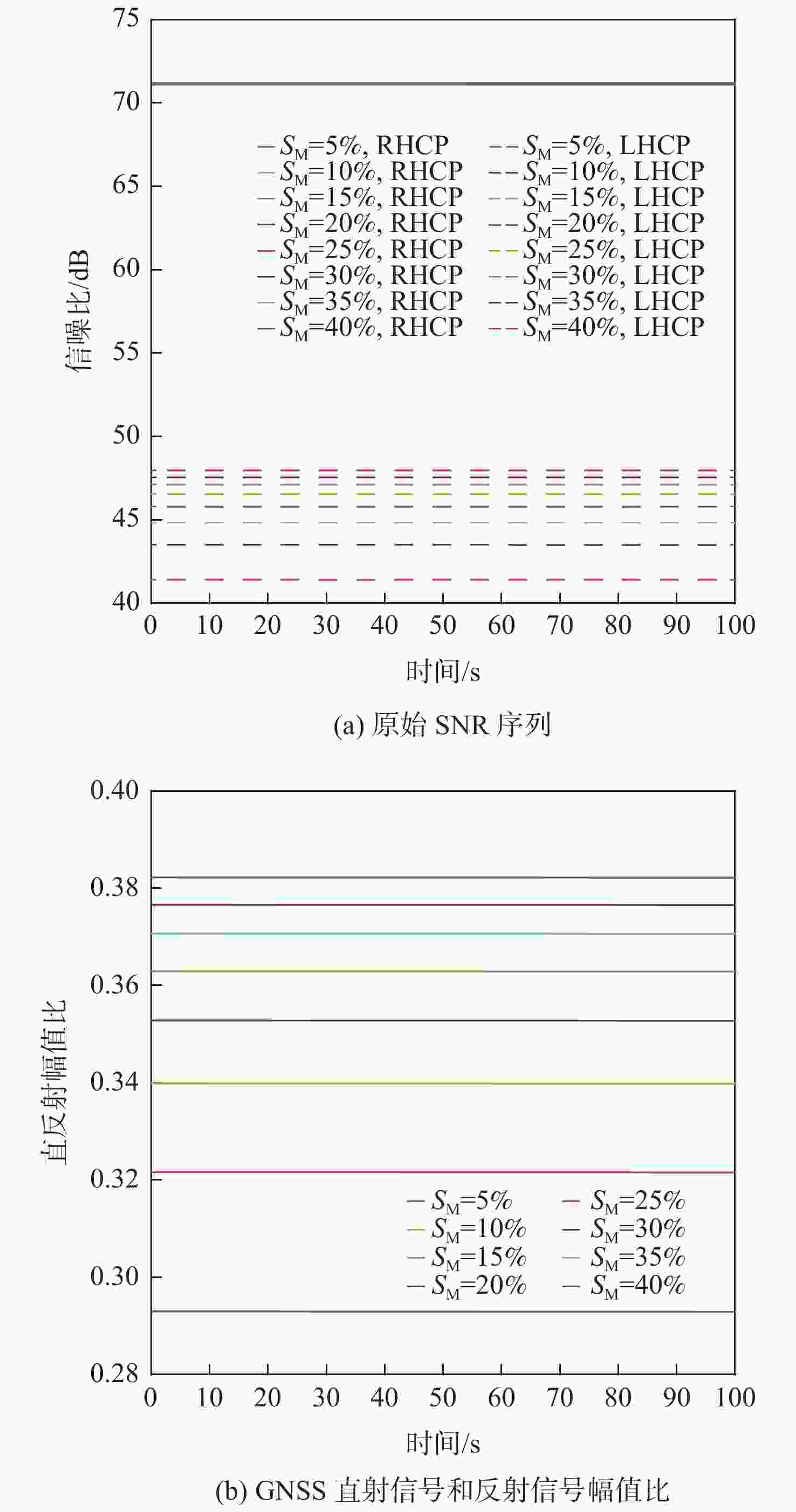
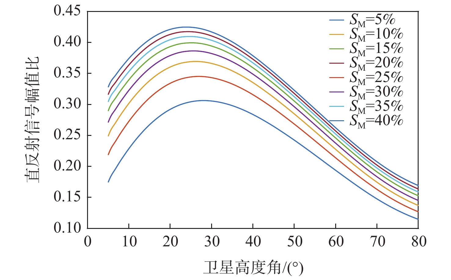
图 5 GEO 卫星直反射信号原始 SNR 和直反射幅值比
Figure 5. Original SNR of GEO satellite direct reflection signal, and direct reflection amplitude ratio

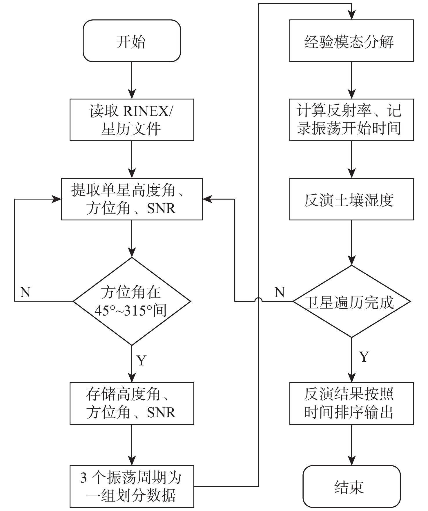
图 7 智能手机反演土壤湿度算法流程图
Figure 7. Flowchart of algorithm for soil moisture inversion by smartphone

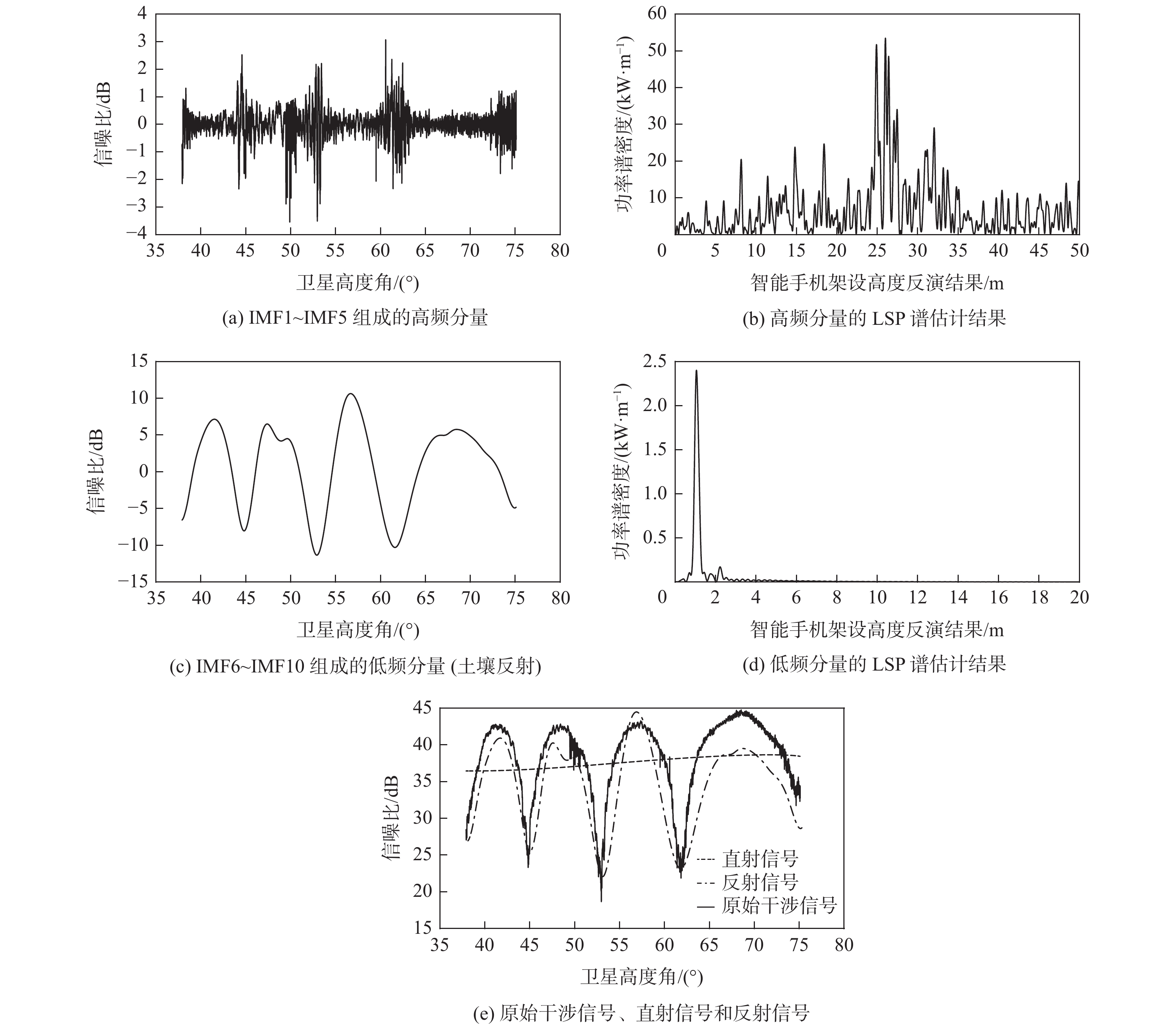
图 10 EMD分解后的本征模式函数及对应的LSP谱估计结果
Figure 10. Intrinsic mode function EMD, and the corresponding LSP spectral estimation results
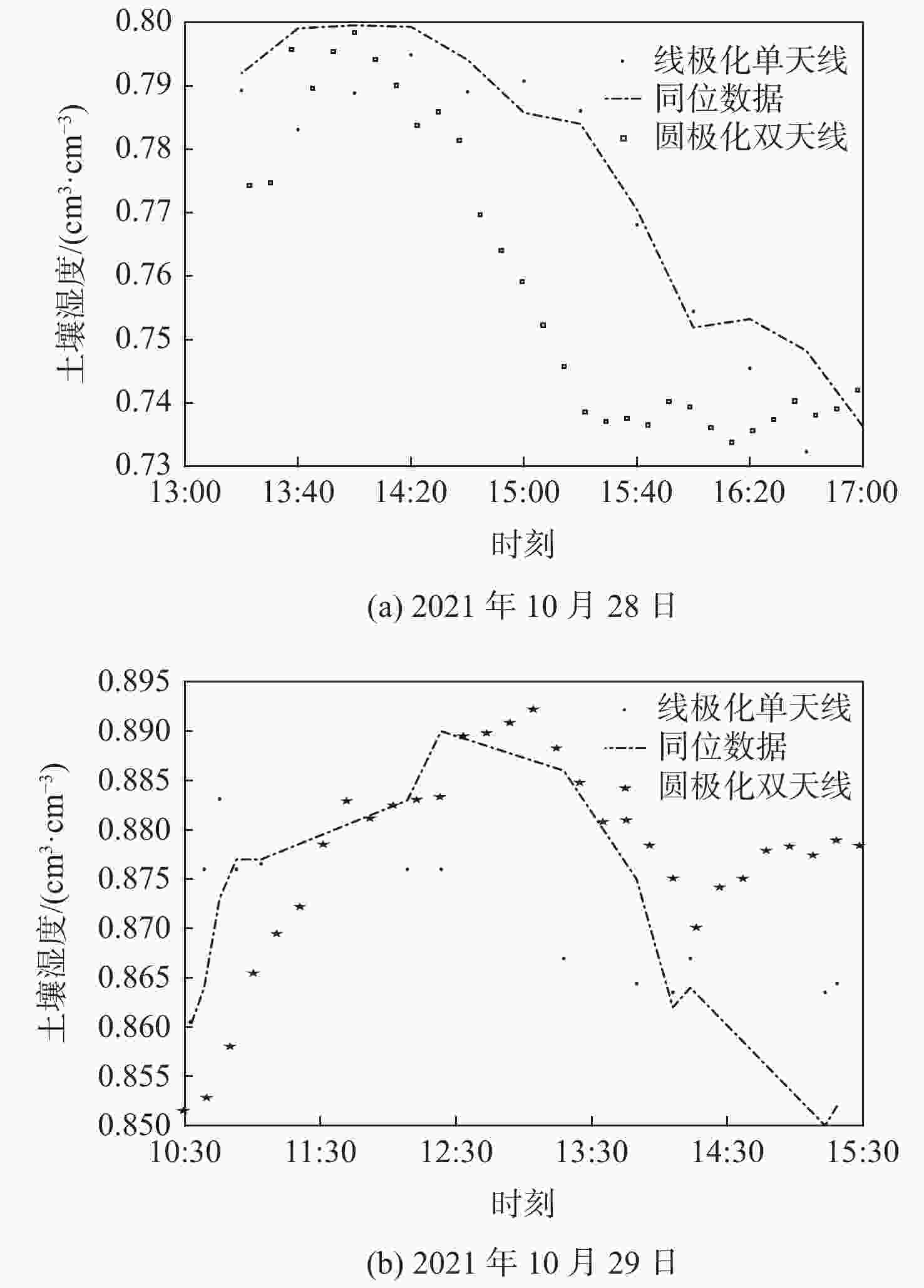
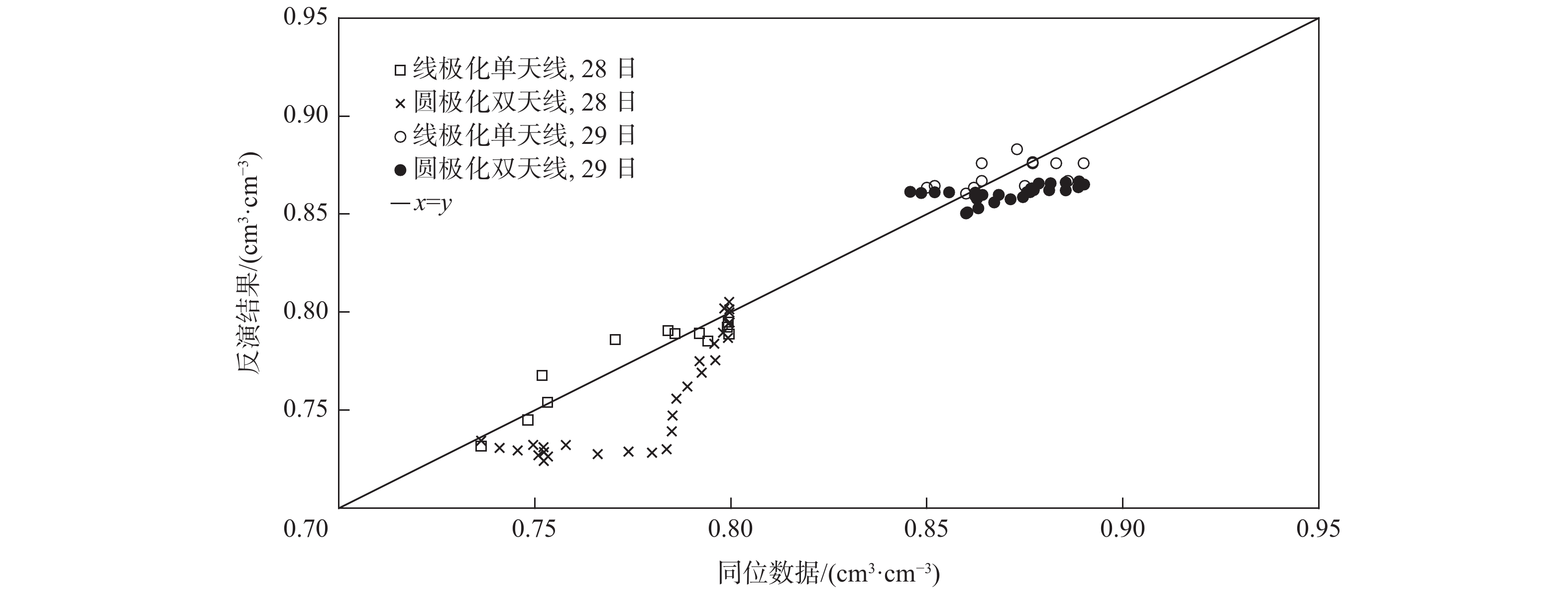
图 11 反演结果与同位数据趋势对比
Figure 11. Comparison of inversion results with in-suit data trends
-
[1] 严颂华, 张训械. 基于GNSS-R信号的土壤湿度反演研究[J]. 电波科学学报, 2010, 25(1): 8-13. doi: 10.13443/j.cjors.2010.01.004YAN S H, ZHANG X X. Retrieving soil moisture based on GNSS-R signals[J]. Chinese Journal of Radio Science, 2010, 25(1): 8-13(in Chinese). doi: 10.13443/j.cjors.2010.01.004 [2] WANG Z M, JIA M M, MAO D H, et al. Remote sensing of spatial distribution of wetlands in Northeast China, 1990-2013[C]//Proceedings of the 2016 IEEE International Geoscience and Remote Sensing Symposium. Piscataway: IEEE Press, 2016: 3539-3542. [3] 王笑蕾, 何秀凤, 陈殊, 等. 地基GNSS-IR风速反演原理及方法初探[J]. 测绘学报, 2021, 50(10): 1298-1307. doi: 10.11947/j.AGCS.2021.20200586WANG X L, HE X F, CHEN S, et al. Preliminary study on theory and method of ground-based GNSS-IR wind speed[J]. Acta Geodaetica et Cartographica Sinica, 2021, 50(10): 1298-1307(in Chinese). doi: 10.11947/j.AGCS.2021.20200586 [4] 宋敏峰, 何秀凤. 基于GNSS-IR技术高精度水库水位监测研究[J]. 无线电工程, 2021, 51(10): 1099-1103. doi: 10.3969/j.issn.1003-3106.2021.10.013SONG M F, HE X F. High-precision reservoir water level monitoring based on GNSS-IR technology[J]. Radio Engineering, 2021, 51(10): 1099-1103(in Chinese). doi: 10.3969/j.issn.1003-3106.2021.10.013 [5] 齐中华, 杨春全, 徐丽丽. 星差分GPS接收机精度测试与在地形测绘方面的应用探索[J]. 测绘与空间地理信息, 2014, 37(8): 217-219. doi: 10.3969/j.issn.1672-5867.2014.08.073QI Z H, YANG C Q, XU L L. Star-based differential GPS receiver precision testing and application of exploration in terms of topographic mapping[J]. Geomatics & Spatial Information Technology, 2014, 37(8): 217-219(in Chinese). doi: 10.3969/j.issn.1672-5867.2014.08.073 [6] 李立勋. 高精度导航接收机天线技术研究[D]. 长沙: 国防科学技术大学, 2016: 8.LI L X. Research on antenna technique for high accuracy navigation Receiver[D]. Changsha: National University of Defense Technology, 2016: 8(in Chinese). [7] 王颖喆, 陶贤露, 朱锋, 等. 利用智能手机实现GNSS原始观测值的高精度差分定位[J]. 武汉大学学报(信息科学版), 2021, 46(12): 1941-1950.WANG Y Z, TAO X L, ZHU F, et al. High accuracy differential positioning with smartphone GNSS raw measurements[J]. Geomatics and Information Science of Wuhan University, 2021, 46(12): 1941-1950(in Chinese). [8] 甘彤, 马冠一. 双线性极化天线的扩频信号合成捕获[C]//第三届中国卫星导航学术年会电子文集-S07北斗/GNSS用户终端技术. 北京: 中国卫星导航系统管理办公室学术交流中心, 2012: 43-47.GAN T, MA G Y. Spread spectrum signal’s synthesis and acquisition algorithm based on dual-linear polarized antenna[C]//The Third Annual China Satellite Navigation Symposium e-Proceedings-S07 Beidou/GNSS User Terminal Technology. Beijing: Academic Exchange Centre of China Satellite Navigation System Administration Office, 2012: 43-47(in Chinese). [9] 王式太, 杨诗妮, 李雪珍. 单双频智能手机GNSS定位精度分析[J]. 测绘通报, 2021(1): 18-23. doi: 10.13474/j.cnki.11-2246.2021.0004WANG S T, YANG S N, LI X Z. Analysis of GNSS positioning accuracy of single and dual frequency smart phone[J]. Bulletin of Surveying and Mapping, 2021(1): 18-23(in Chinese). doi: 10.13474/j.cnki.11-2246.2021.0004 [10] LARSON K M, SMALL E E, GUTMANN E, et al. Using GPS multipath to measure soil moisture fluctuations: Initial results[J]. GPS Solutions, 2008, 12: 173-177. doi: 10.1007/s10291-007-0076-6 [11] ZAVOROTNY V U, LARSON K M, BRAUN J J, et al. A physical model for GPS multipath caused by land reflections: Toward bare soil moisture retrievals[J]. IEEE Journal of Selected Topics in Applied Earth Observations and Remote Sensing, 2010, 3(1): 100-110. doi: 10.1109/JSTARS.2009.2033608 [12] 汉牟田, 张波, 杨东凯, 等. 利用GNSS干涉信号振荡幅度反演土壤湿度[J]. 测绘学报, 2016, 45(11): 1293-1300. doi: 10.11947/j.AGCS.2016.20160145HAN M T, ZHANG B, YANG D K, et al. Soil moisture retrieval utilizing GNSS interference signal amplitude[J]. Acta Geodaetica et Cartographica Sinica, 2016, 45(11): 1293-1300(in Chinese). doi: 10.11947/j.AGCS.2016.20160145 [13] ROUSSEL N, FRAPPART F, RAMILLIEN G, et al. Detection of soil moisture variations using GPS and GLONASS SNR data for elevation angles ranging from 2° to 70°[J]. IEEE Journal of Selected Topics in Applied Earth Observations and Remote Sensing, 2016, 9(10): 4781-4794. doi: 10.1109/JSTARS.2016.2537847 [14] 邹文博, 张波, 洪学宝, 等. 利用北斗GEO卫星反射信号反演土壤湿度[J]. 测绘学报, 2016, 45(2): 199-204. doi: 10.11947/j.AGCS.2016.20150135ZONG W B, ZHANG B, HONG X B, et al. Soil moisture retrieval using reflected signals of BeiDou GEO satellites[J]. Acta Geodaeticaet et Cartographica Sinica, 2016, 45(2): 199-204(in Chinese). doi: 10.11947/j.AGCS.2016.20150135 [15] YANG T, WAN W, CHEN X W, et al. Using BDS SNR observations to measure near-surface soil moisture fluctuations: Results from low vegetated surface[J]. IEEE Geoscience and Remote Sensing Letters, 2017, 14(8): 1308-1312. doi: 10.1109/LGRS.2017.2710083 [16] 荆丽丽, 杨磊, 汉牟田, 等. GNSS-IR双频数据融合的土壤湿度反演方法[J]. 北京航空航天大学学报, 2019, 45(6): 1248-1255. doi: 10.13700/j.bh.1001-5965.2018.0555JING L L, YANG L, HAN M T, et al. Soil moisture inversion method based on GNSS-IR dual frequency data fusion[J]. Journal of Beijing University of Aeronautics and Astronsutics, 2019, 45(6): 1248-1255(in Chinese). doi: 10.13700/j.bh.1001-5965.2018.0555 [17] 孙波, 张弛, 尹世超, 等. 基于PSO-RF的GNSS-IR土壤湿度反演方法研究[J]. 无线电工程, 2021, 51(10): 1080-1085. doi: 10.3969/j.issn.1003-3106.2021.10.010SUN B, ZHANG C, YIN S C, et al. Research on GNSS-IR soil moisture inversion method based on PSO-RF[J]. Radio Engineering, 2021, 51(10): 1080-1085(in Chinese). doi: 10.3969/j.issn.1003-3106.2021.10.010 [18] 张志刚, 梁月吉, 任超, 等. 小波多尺度和多星融合的GPS-IR土壤湿度反演[J]. 测绘科学技术学报, 2020, 37(2): 133-137.ZHANG Z G, LIANG Y J, REN C, et al. GPS-IR soil moisture inversion combined with wavelet multi-scale and multi-star fusion[J]. Journal of Geomatics Science and Technology, 2020, 37(2): 133-137(in Chinese). [19] 王丽霞, 王涛, 张双成, 等. 基于长时间序列SNR数据的土壤湿度反演[C]//第十一届中国卫星导航年会论文-S01卫星导航行业应用. 北京: 中国卫星导航系统管理办公室学术交流中心, 2020: 94-99.WANG L X, WANG T, ZHANG S C, et al. Measurement of soil moisture using long time series data of SNR[C]//Proceedings of the 11th Annual China Satellite Navigation Conference-S01 Satellite Navigation Industry Applications. Beijing: Academic Exchange Centre of China Satellite Navigation System Administration Office, 2020: 94-99(in Chinese). [20] KOCH F, SCHLENZ F, PRASCH M, et al. Soil moisture retrieval based on GPS signal strength attenuation[J]. Water, 2016, 8(7): 276. doi: 10.3390/w8070276 [21] 汉牟田, 杨毅, 张波. GNSS信号土壤衰减模型的试验验证方法[J]. 测绘学报, 2020, 49(9): 1202-1212. doi: 10.11947/j.AGCS.2020.20200259HAN M T, YANG Y, ZHANG B. An experimental validation method on GNSS signal attenuation model in soil[J]. Acta Geodaetica et Cartographica Sinica, 2020, 49(9): 1202-1212(in Chinese). doi: 10.11947/j.AGCS.2020.20200259 [22] 陈波, 高成发, 刘永胜, 等. 安卓手机终端原始GNSS观测数据质量分析[J]. 导航定位学报, 2019, 7(3): 87-95. doi: 10.3969/j.issn.2095-4999.2019.03.015CHEN B, GAO C F, LIU Y S, et al. Quality analysis on raw GNSS measurements of Android mobile terminals[J]. Journal of Navigation and Positioning, 2019, 7(3): 87-95(in Chinese). doi: 10.3969/j.issn.2095-4999.2019.03.015 [23] KURUM M, FARHAD M M, GURBUZ A C. Integration of smartphones into small unmanned aircraft systems to sense water in soil by using reflected GPS signals[J]. IEEE Journal of Selected Topics in Applied Earth Observations and Remote Sensing, 2021, 14: 1048-1059. doi: 10.1109/JSTARS.2020.3041162 [24] ALTUNTAS C, TUNALIOGLU N. Feasibility of retrieving effective reflector height using GNSS-IR from a single-frequency android smartphone SNR data[J]. Digital Signal Processing, 2021, 112: 1051-2004. [25] 张垠, 涂锐, 洪菊, 等. Android智能手机GNSS数据质量分析[J]. 全球定位系统, 2021, 46(4): 85-92. doi: 10.12265/j.gnss.2021042501ZHANG Y, TU R, HONG J, et al. Quality assessment of Android smartphone with GNSS raw observations[J]. GNSS World of China, 2021, 46(4): 85-92(in Chinese). doi: 10.12265/j.gnss.2021042501 [26] 李惟, 朱云龙, 王峰, 等. GNSS多径信号模型及测高方法[J]. 北京航空航天大学学报, 2018, 44(6): 1239-1245. doi: 10.13700/j.bh.1001-5965.2017.0417LI W, ZHU Y L, WANG F, et al. GNSS multipath signal model and altimetry method[J]. Journal of Beijing University of Aeronautics and Astronautics, 2018, 44(6): 1239-1245(in Chinese). doi: 10.13700/j.bh.1001-5965.2017.0417 [27] 杨东凯, 张其善. GNSS反射信号处理基础与实践[M]. 北京: 电子工业出版社, 2012: 8.YANG D K, ZHANG Q S. GNSS reflected signal processing: Fundamentals and applications[M]. Beijing: Publishing House of Electronics Industry, 2012: 8(in Chinese). [28] 苏东林, 陈爱新, 谢树果, 等. 电磁场与电磁波[M]. 北京: 高等教育出版社, 2009: 416-425.SU D L, CHEN A X, XIE S G, et al. Electromagnetic fields and waves[M]. Beijing: Higher Education Press, 2009: 416-425(in Chinese). [29] MARTIN A, IBANEZ S, BAIXAULI C, et al. Multi-constellation GNSS interferometric reflectometry with mass-market sensors as a solution for soil moisture monitoring[J]. Hydrology and Earth System Sciences, 2020, 24(7): 3573-3582. doi: 10.5194/hess-24-3573-2020 [30] 杨磊. GNSS-R农田土壤湿度反演方法研究[D]. 济南: 山东农业大学, 2017: 45-56.YANG L. Study of GNSS-R cropland soil moisture retrieval method[D]. Jinan: Shandong Agricultural University, 2017: 45-56(in Chinese). [31] VANDERPLAS J T. Understanding the Lomb-Scargle periodogram[J]. The Astrophysical Journal Supplement Series, 2018, 236(1): 16. doi: 10.3847/1538-4365/aab766 [32] 王燕, 薛云朝, 马铁华. 基于EMD和最小二乘法的零漂处理方法研究[J]. 北京理工大学学报, 2015, 35(2): 118-122. doi: 10.15918/j.tbit1001-0645.2015.02.002WANG Y, XUE Y Z, MA T H. Research on zero drift processing method using EMD and least-square[J]. Transactions of Beijing Institute of Technology, 2015, 35(2): 118-122(in Chinese). doi: 10.15918/j.tbit1001-0645.2015.02.002 [33] TOPP G C, DAVIS J L, ANNAN A P. Electromagnetic determination of soil water content: Measurements in coaxial transmission lines[J]. Water Resources Research, 1980, 16(3): 574-582. doi: 10.1029/WR016i003p00574 -

 下载:
下载:


 点击查看大图
计量
- 文章访问数: 401
- HTML全文浏览量: 34
- PDF下载量: 7
- 被引次数: 0
