


-
摘要:
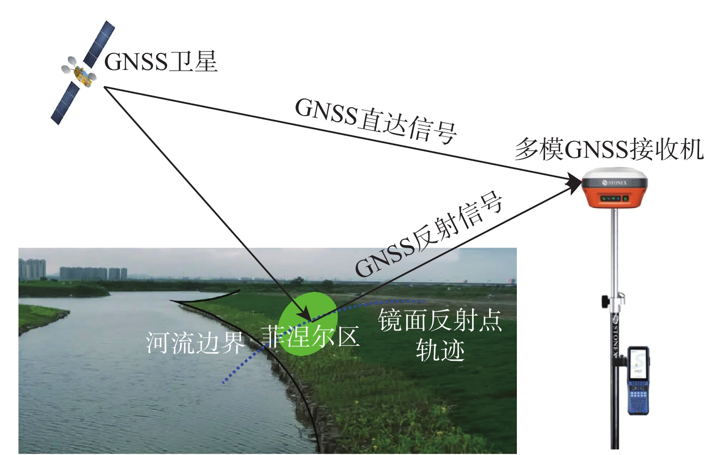
从几何构型和理论模型2个角度探究全球导航卫星系统干涉/多径反射测量(GNSS-I/MR)技术提取河流边界和测量河流水位的可行性。基于河流/河岸介电常数的差异性和河岸相对于河流存在斜度的事实,定义对河流边界敏感的反-直比和实验变化率2个观测量。在希尔伯特变换估计的载噪比包络和相位的基础上,提出基于一元二次方程求解反-直比和线性拟合实验变化率的估计方法,以及3-阈值最大类间方差识别河流/河岸和循环拟合提取河流边界的方法。基于河流表面的实验变化率测量河流水位,通过搭建仿真平台和设计2种河流场景,仿真验证所提方法的有效性。仿真结果表明:在设定参数下,利用介电常数检测场景1和场景2河流边界的均方根误差分别为1.47 m和1.13 m;实验变化率检测场景1和场景2河流边界的均方根误差分别为0.49 m和0.35 m;场景1和场景2的测量高度和真实值的误差分别为0.09 m和0.13 m。
Abstract:This paper explored the feasibility of extracting the river boundary and measuring the river level using global navigation satellite system-interferometric/multipath reflectometry (GNSS-I/MR) from its geometry and theoretical models. Based on the difference in the dielectric constant between the bank and river and the fact that the bank has a slope relative to the river, two observational variables sensitive to river boundary, namely the reflected-to-direct ratio and the delay rate were defined. According to the estimated envelope and phase of carrier-to-noise ratio using Hilbert transform, this paper proposed the estimation method of the reflected-to-direct ratio based on a univariate quadratic equation and that of the delay rate based on linear fitting, as well as a 3-threshold maximum interclass variance-based algorithm to recognize river/bank and a looped fitting-based algorithm to extract the river boundary. The river level was measured based on the delay rate of the river surface. By setting up a simulation platform and designing two river scenarios, the effectiveness of the proposed method was verified through simulation.
-
Key words:
- GNSS-IR /
- river boundary /
- river level /
- Hilbert transform /
- maximum interclass variance /
- looped fitting
-
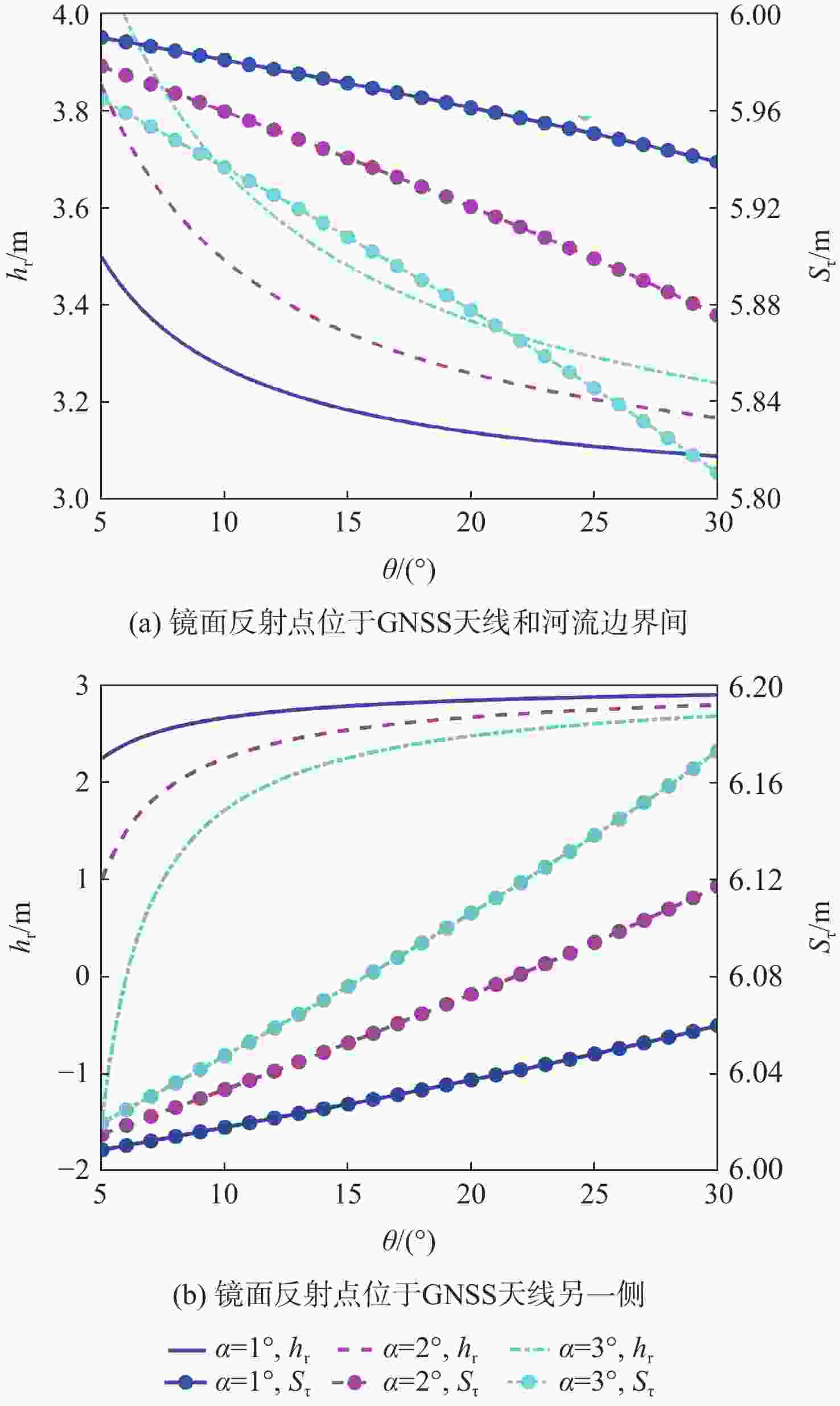
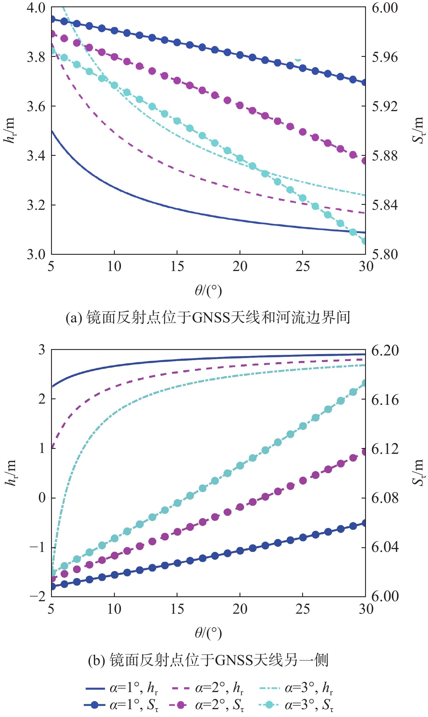
图 2 天线距镜面反射点垂直高度、实验变化率与卫星高度角的关系
Figure 2. Relationship among vertical height from antenna to mirror reflection point, delay rate, and satellite elevation angle
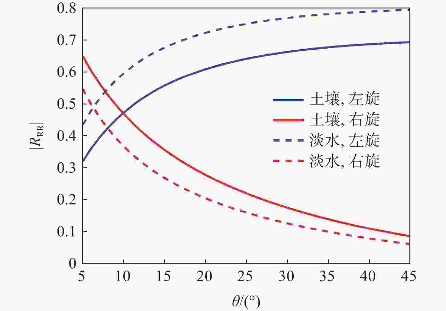
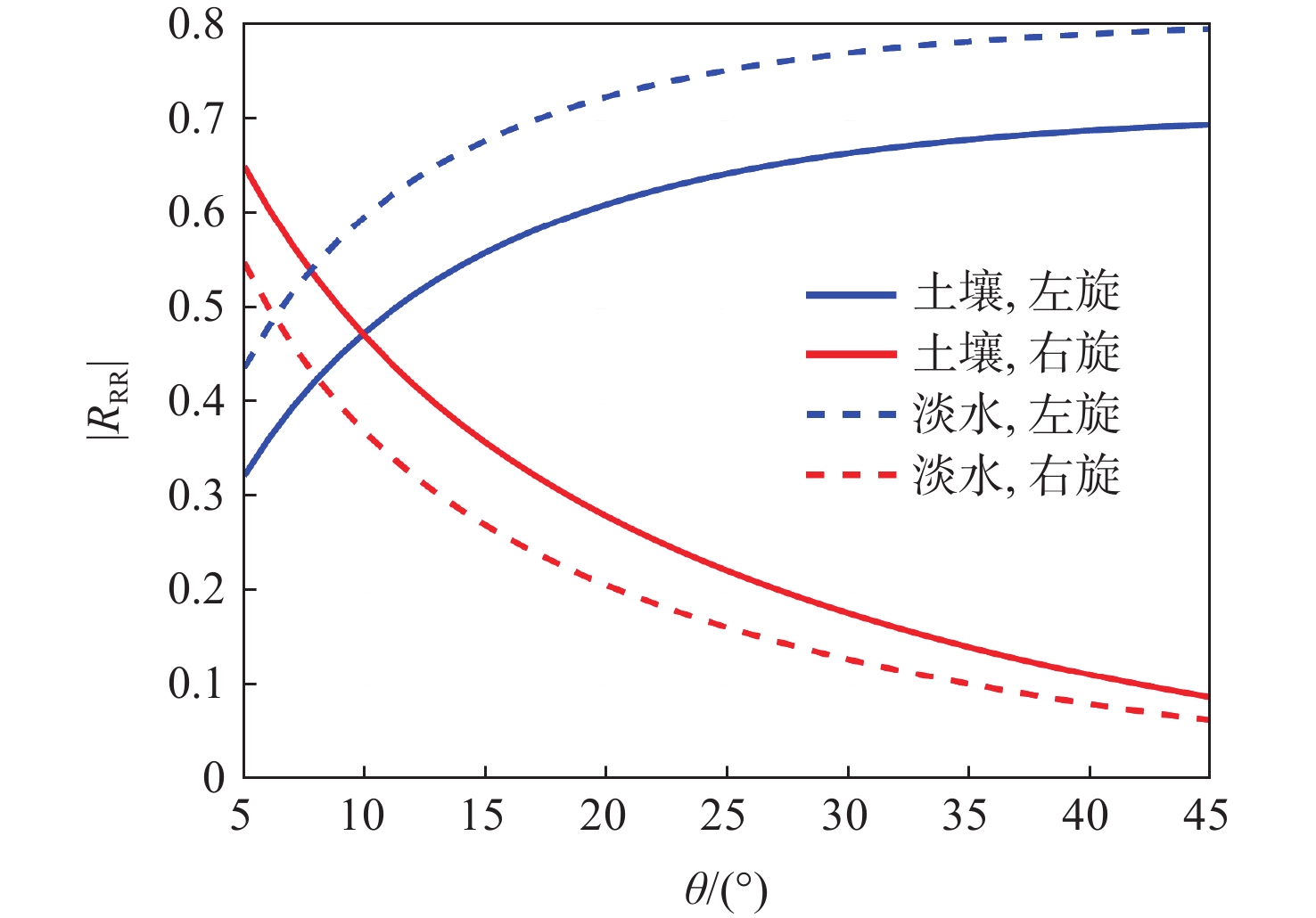
图 3 淡水和土壤表面反射系数幅度随卫星高度角的变化
Figure 3. Variation of reflection coefficient amplitude of freshwater and soil with satellite elevation angle
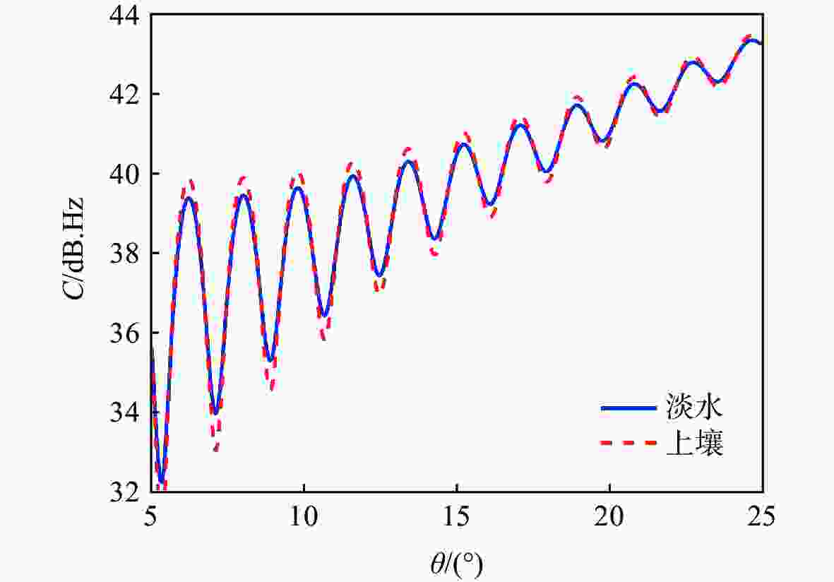
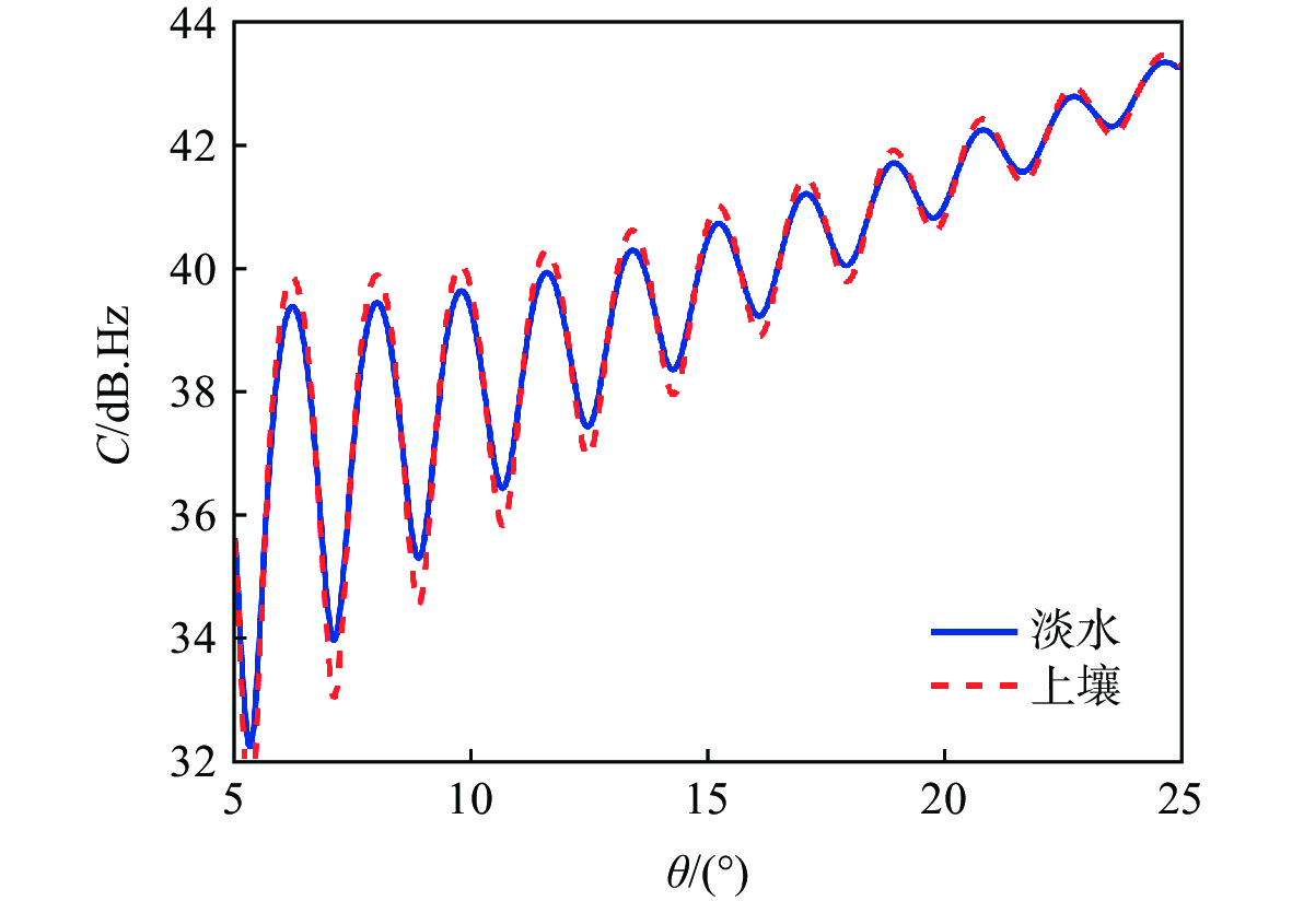
图 4 淡水和土壤表面的GNSS-IR的载噪比
Figure 4. Carrier-to-noise ratio of GNSS-IR from freshwater and soil surfaces
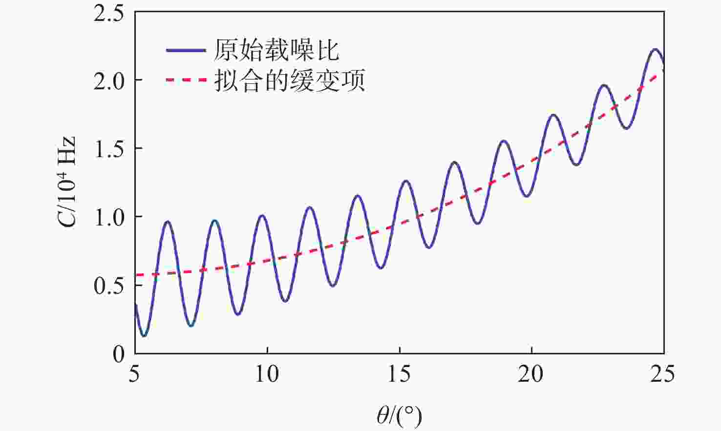
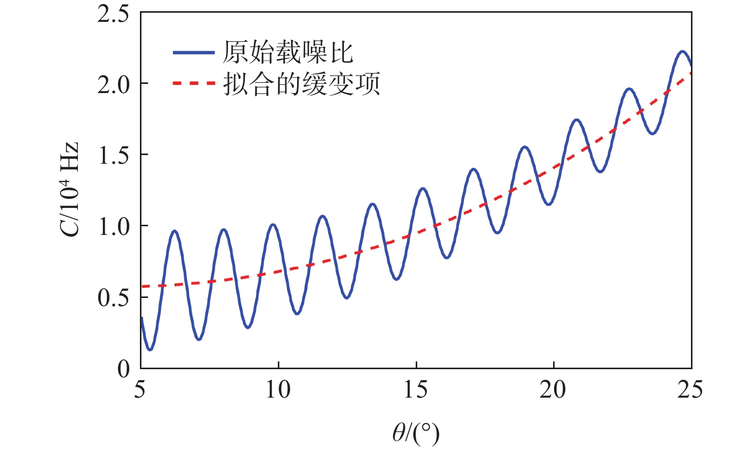
图 6 原始载噪比序列和拟合的缓变趋势项
Figure 6. Original carrier-to-noise ratio sequence and fitted slow trend term
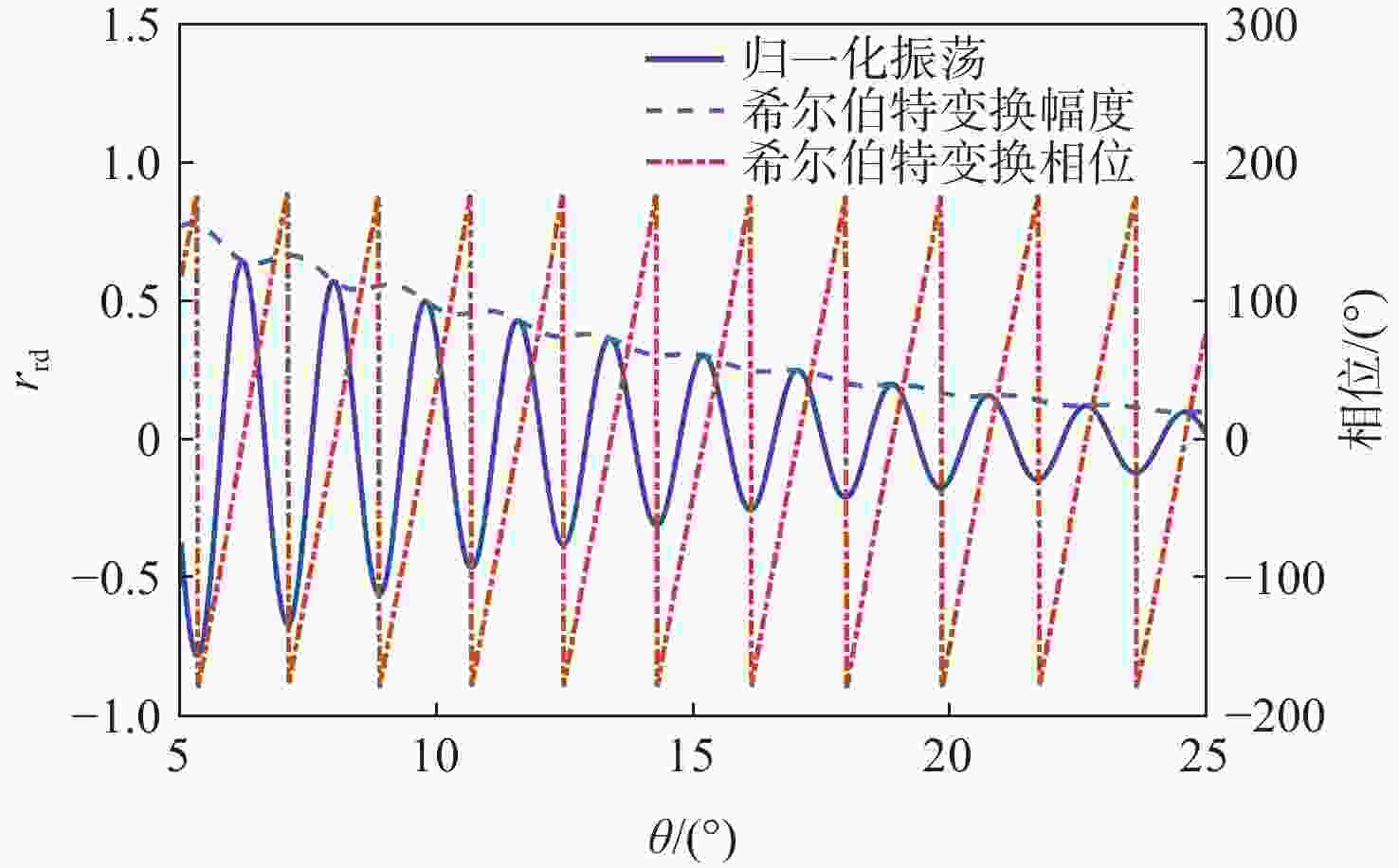
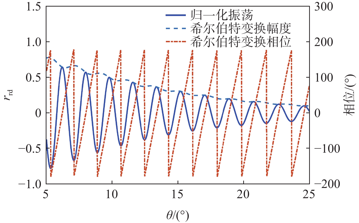
图 7 归一化振荡、希尔伯特变换估计的振荡包络和相位
Figure 7. Normalized oscillation and estimated oscillation envelope and phase using Hilbert transform

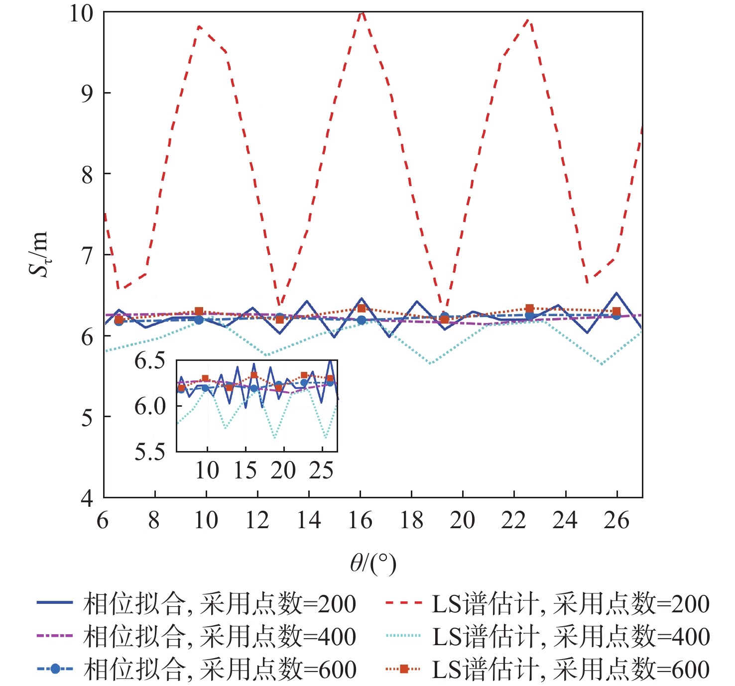
图 8 不同采用点数的线性拟合和LS谱估计的实验变化率
Figure 8. Delay rate using linear fitting and LS spectrum with different sampling number
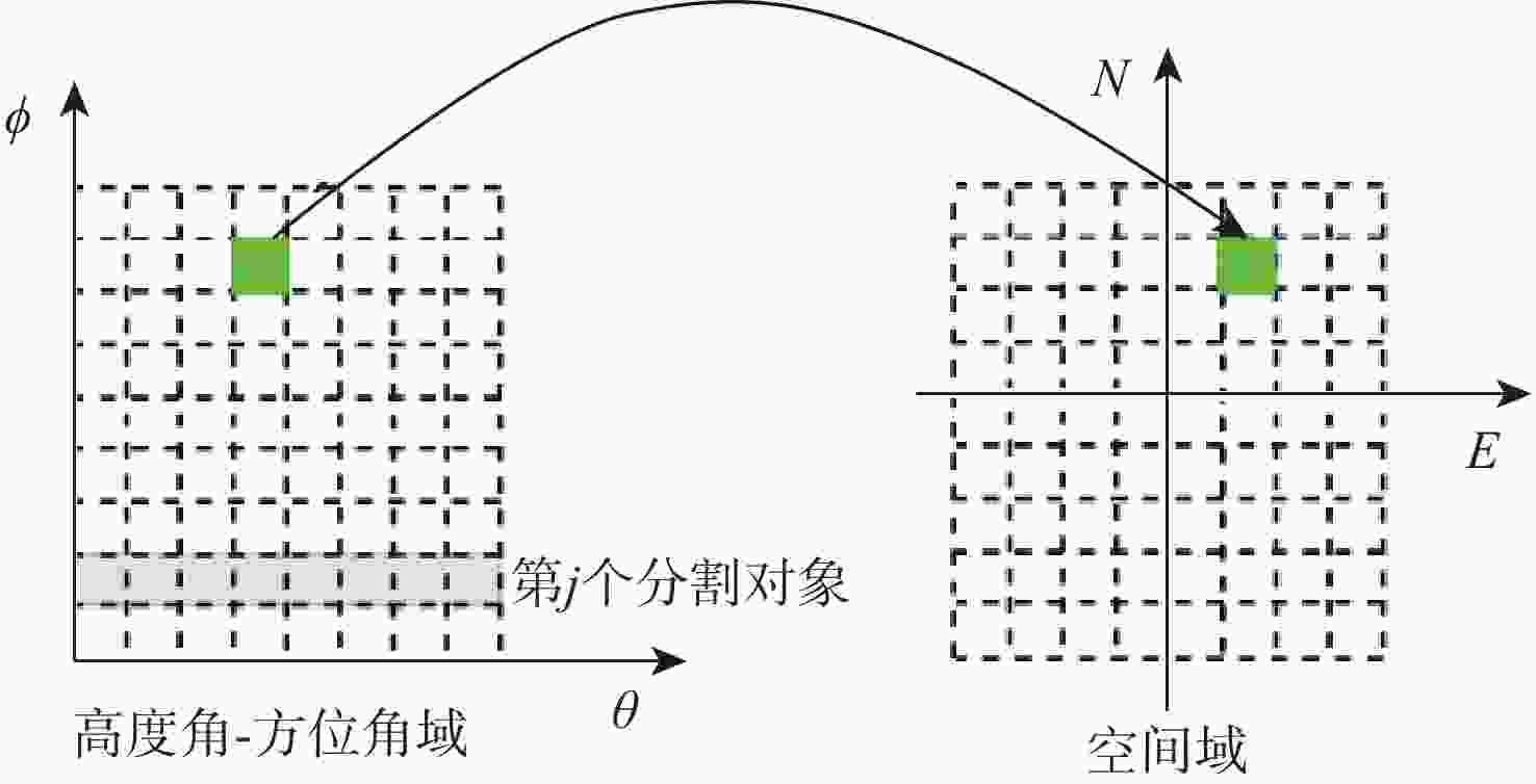
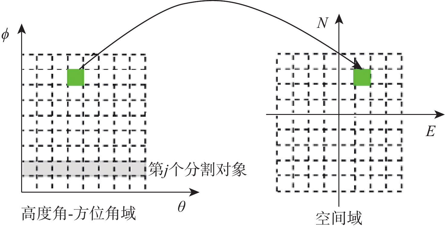
图 9 高度角-方位角域和空间域的映射示意图
Figure 9. Schematic diagram of mapping from elevation angle-azimuth domain to space domain
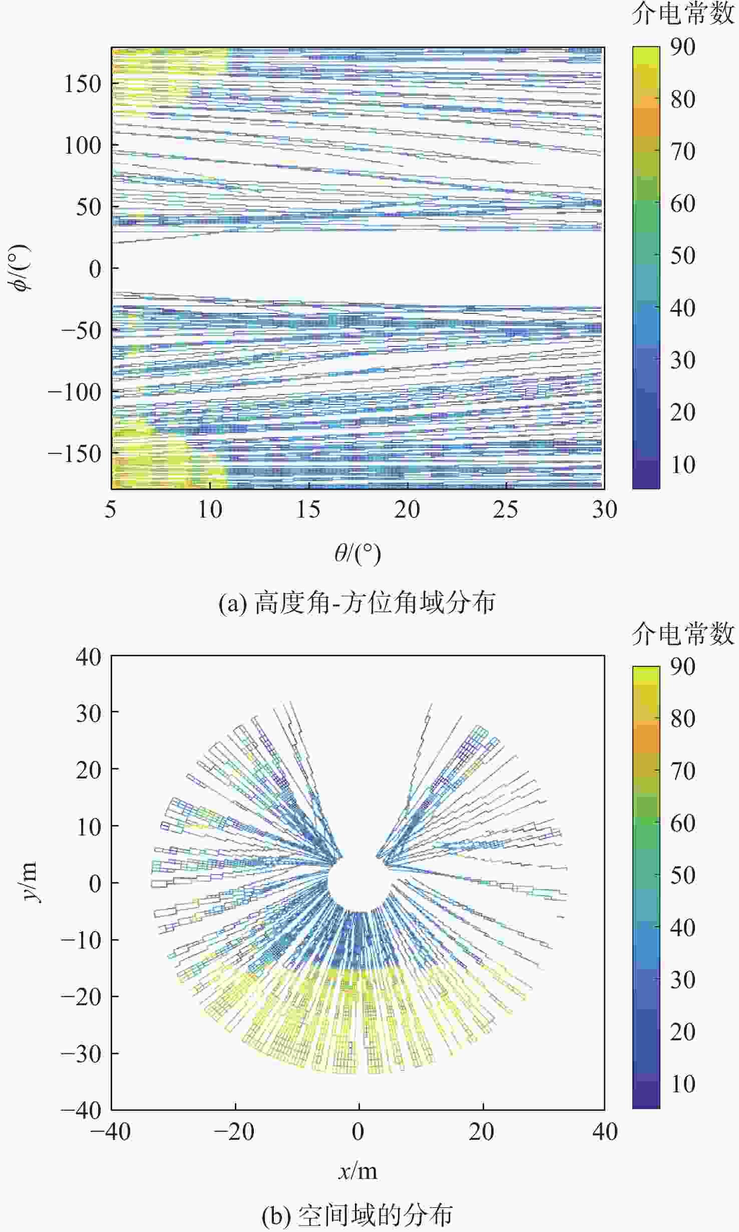
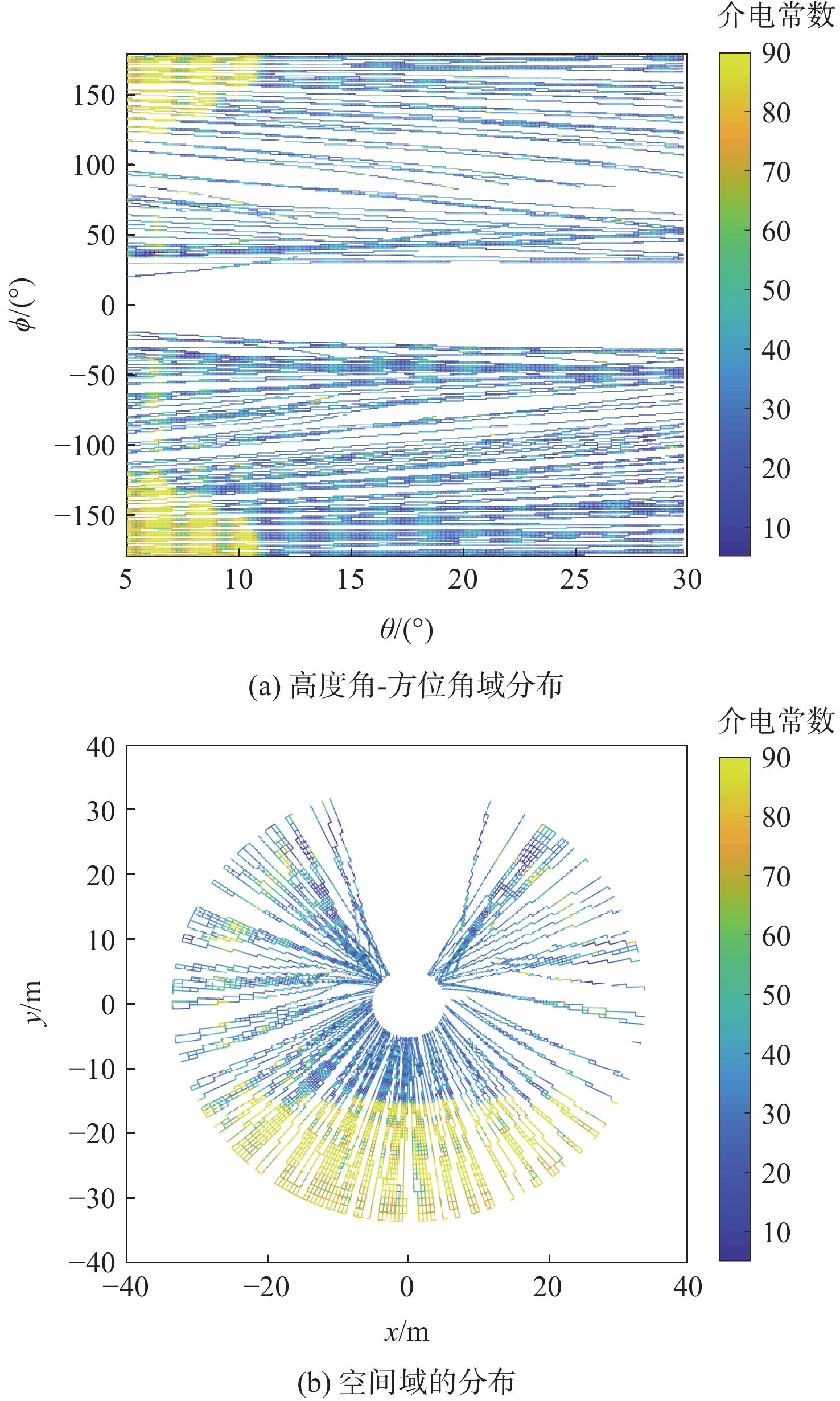
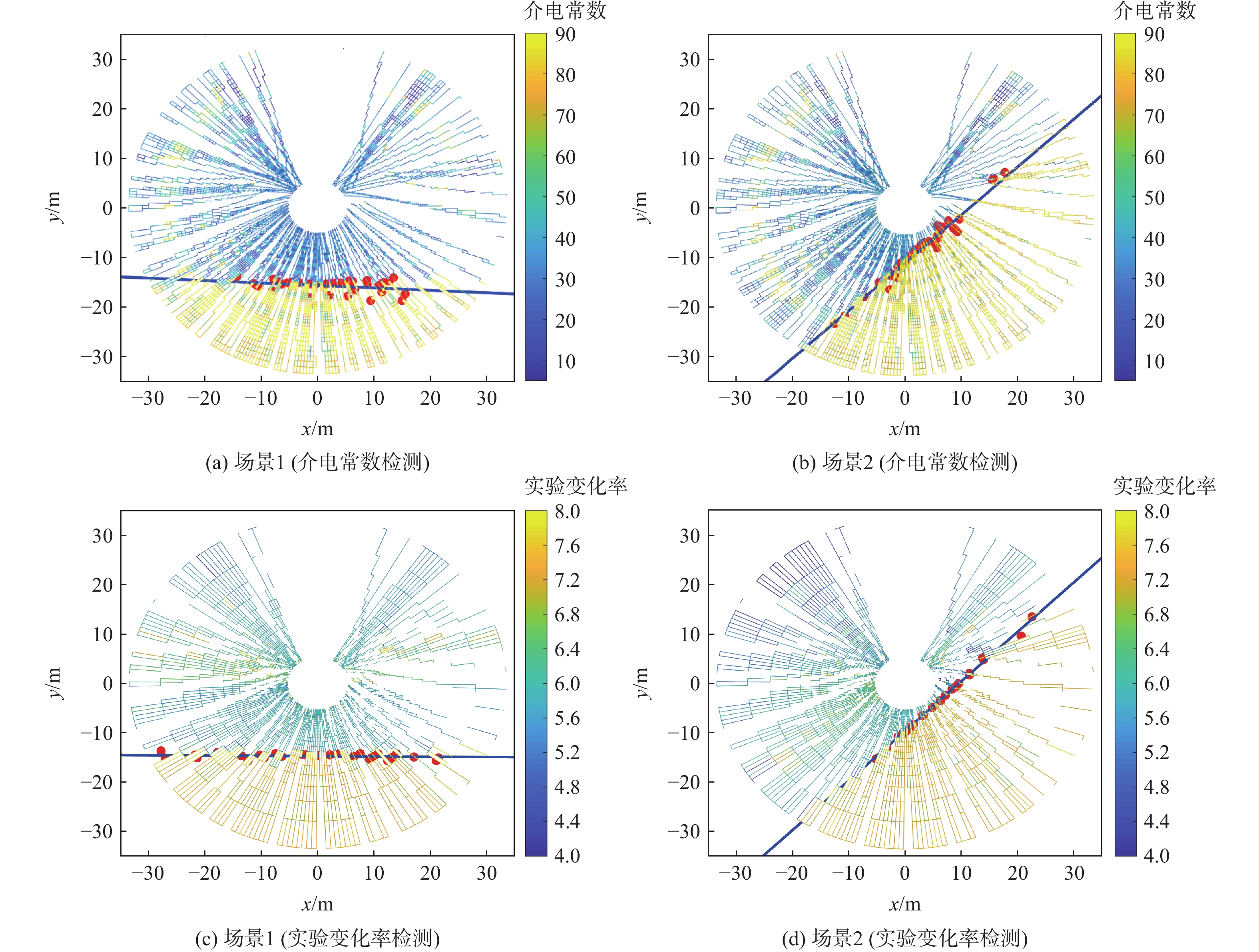
图 13 场景1中反演的介电常数分布
Figure 13. Distribution of retrieved dielectric constant for scenario 1
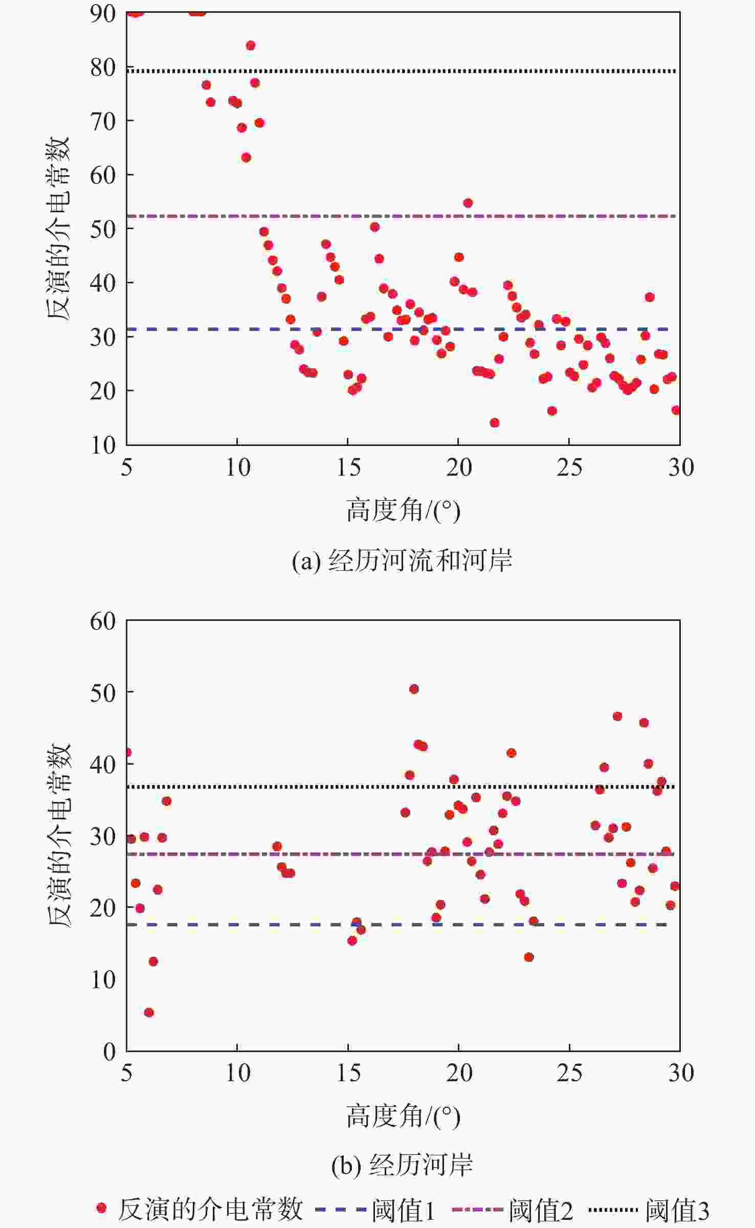
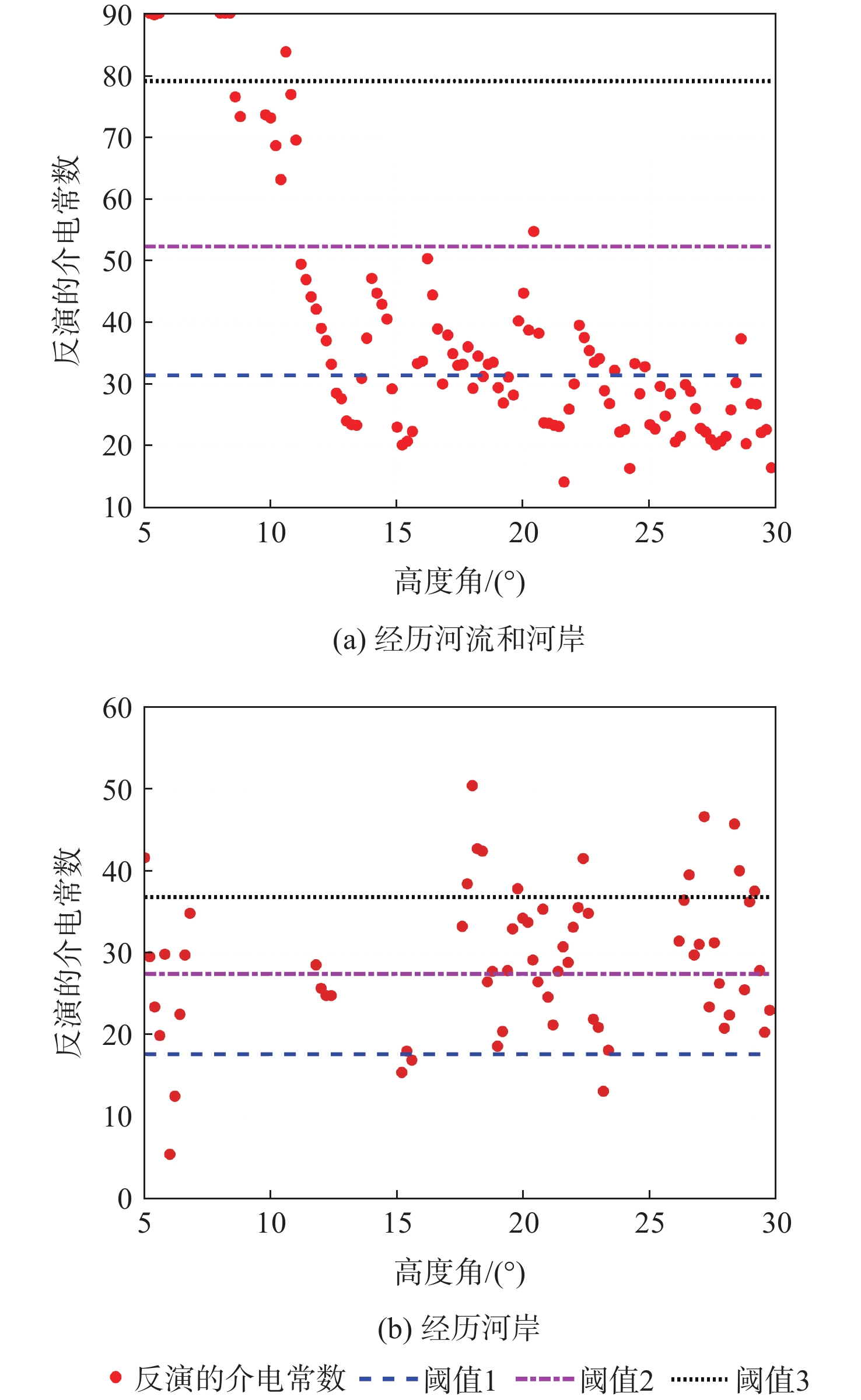
图 14 镜面反射点介电常数随高角度变化
Figure 14. Dielectric constant of specular reflection point versus elevation angle
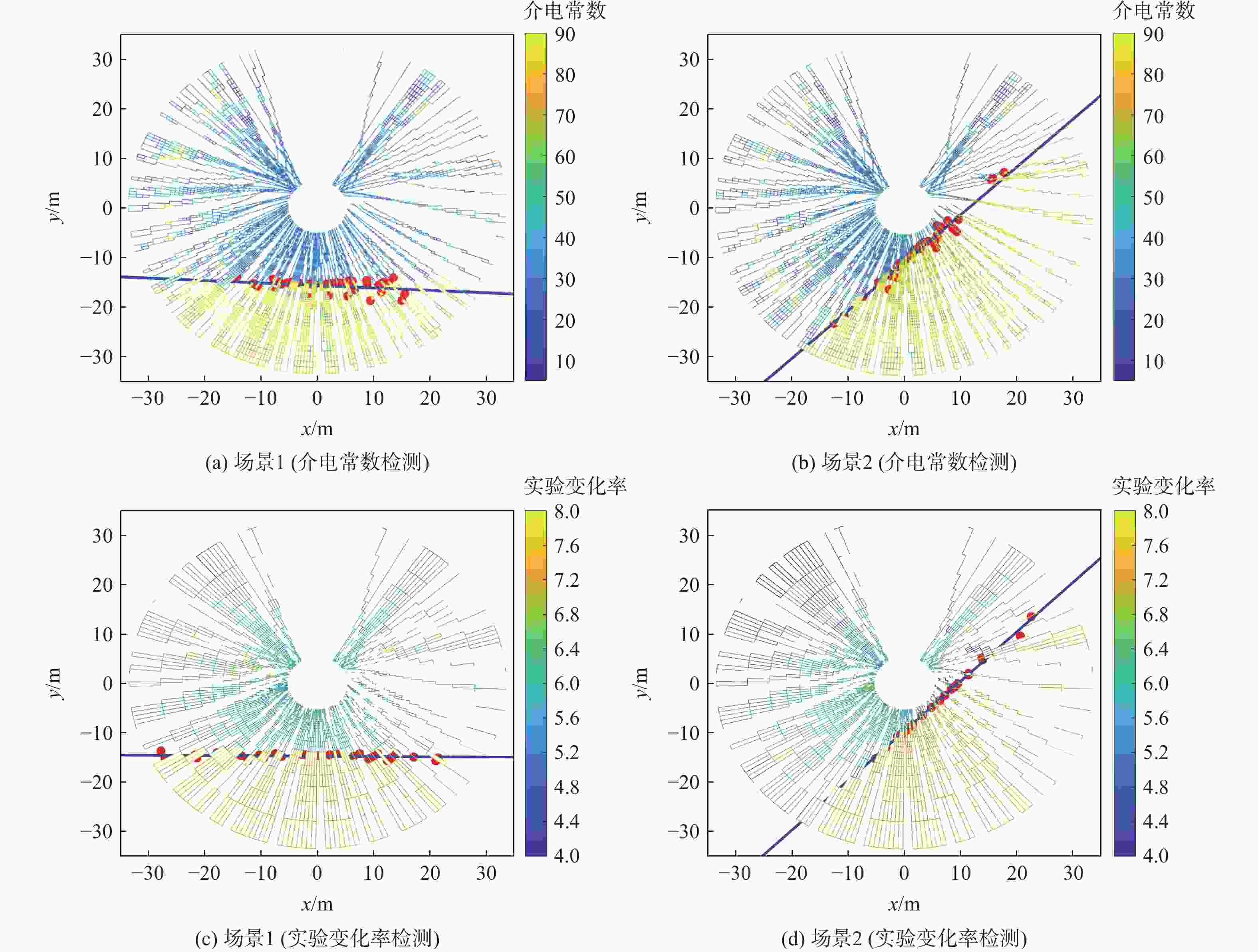
图 15 利用介电常数和实验变化率检测的仿真场景1和场景2的河流边界
Figure 15. Detected river boundaries in simulation scenarios 1 and 2 using dielectric constant and delay rate
-
[1] 伍光和, 王乃昂, 胡双熙, 等. 自然地理学[M]. 4版. 北京: 高等教育出版社, 2008: 202-222.WU G H, WANG N A, HU S X, et al. Physical geography[M]. 4th ed. Beijing: Higher Education Press, 2008: 202-222 (in Chinese). [2] 吴炳方. 流域遥感[M]. 北京: 科学出版社, 2019: 42.WU B F. Watershed remote sensing[M]. Beijing: Science Press, 2019: 42 (in Chinese). [3] 中华人民共和国应急管理部. 2020 年全国自然灾害基本情况[EB/OL]. (2021-01-08)[2021-03-22]. https://www.mem.gov.cn/xw/yjglbgzdt/202101/t20210108_376745.shtml.Ministry of Emergency Management of the People’s Republic of China. Baisc information of natural disasters in China in 2020[EB/OL]. (2021-01-08)[2021-03-22]. https://www.mem.gov.cn/xw/yjglbgzdt/202101/t20210108_376745.shtml(in Chinese). [4] 史卓琳, 黄昌. 河流水情要素遥感研究进展[J]. 地理科学进展, 2020, 39(4): 670-684. doi: 10.18306/dlkxjz.2020.04.014SHI Z L, HUANG C. Recent advances in remote sensing of river characteristics[J]. Progress in Geography, 2020, 39(4): 670-684 (in Chinese). doi: 10.18306/dlkxjz.2020.04.014 [5] KINOSHITA R, UTAMI T, UENO T. Image processing for aerial photographs of flood flow[J]. Journal of the Japan Society of Photogrammetry and Remote Sensing, 1990, 29(6): 4-17. doi: 10.4287/jsprs.29.6_4 [6] COSTA J E, CHENG R T, HAENI F P, et al. Use of radars to monitor stream discharge by noncontact methods[J]. Water Resources Research, 2006, 42(7): W07422. [7] LYZENGA D R. Passive remote sensing techniques for mapping water depth and bottom features[J]. Applied Optics, 1978, 17(3): 379-383. doi: 10.1364/AO.17.000379 [8] VILLADSEN H, ANDERSEN O B, STENSENG L, et al. CryoSat-2 altimetry for river level monitoring—Evaluation in the Ganges-Brahmaputra River Basin[J]. Remote Sensing of Environment, 2015, 168: 80-89. doi: 10.1016/j.rse.2015.05.025 [9] BRAKENRIDGE G R, NGHIEM S V, ANDERSON E, et al. Space-based measurement of river runoff[J]. Eos, Transactions American Geophysical Union, 2005, 86(19): 185-188. [10] HALL C D, CORDEY R A. Multistatic scatterometry[C]//Proceedings of the International Geoscience and Remote Sensing Symposium, 'Remote Sensing: Moving Toward the 21st Century'. Piscataway: IEEE Press, 2002: 561-562. [11] MARTIN-NEIRA M. A pasive reflectometry and interferometry system (PARIS) application to ocean altimetry[J]. ESA Journal, 1993, 17(4): 331-355. [12] 杨东凯, 王峰. GNSS反射信号海洋遥感方法及应用[M]. 北京: 科学出版社, 2020: 15-16.YANG D K, WANG F. Method and application of ocean remote sensing based on GNSS reflection signal[M]. Beijing: Science Press, 2020: 15-16 (in Chinese). [13] DAHL-JENSEN T S, ANDERSEN O B, WILLIAMS S D P, et al. GNSS-IR measurements of inter annual sea level variations in Thule, Greenland from 2008—2019[J]. Remote Sensing, 2021, 13(24): 5077. doi: 10.3390/rs13245077 [14] 王笑蕾, 何秀凤, 陈殊, 等. 地基GNSS-IR风速反演原理及方法初探[J]. 测绘学报, 2021, 50(10): 1298-1307. doi: 10.11947/j.AGCS.2021.20200586WANG X L, HE X F, CHEN S, et al. Preliminary study on theory and method of ground-based GNSS-IR wind speed[J]. Acta Geodaetica et Cartographica Sinica, 2021, 50(10): 1298-1307 (in Chinese). doi: 10.11947/j.AGCS.2021.20200586 [15] GHIASI Y, DUGUAY C R, MURFITT J, et al. Application of GNSS interferometric reflectometry for the estimation of lake ice thickness[J]. Remote Sensing, 2020, 12(17): 2721. doi: 10.3390/rs12172721 [16] 孙波, 梁勇, 汉牟田, 等. 基于GPS多星三频数据融合的GNSS-IR土壤湿度反演方法[J]. 北京航空航天大学学报, 2020, 46(6): 1089-1096.SUN B, LIANG Y, HAN M T, et al. A method for GNSS-IR soil moisture inversion based on GPS multi-satellite and triple-frequency data fusion[J]. Journal of Beijing University of Aeronautics and Astronautics, 2020, 46(6): 1089-1096 (in Chinese). [17] LI Y W, YU K G, CHANG X, et al. Estimation of wheat height with SNR observations collected by low-cost navigational GNSS chip and RHCP antenna[J]. IEEE Geoscience and Remote Sensing Letters, 1809, 19: 8024905. [18] LARSON K M, NIEVINSKI F G. GPS snow sensing: Results from the EarthScope Plate Boundary Observatory[J]. GPS Solutions, 2013, 17(1): 41-52. doi: 10.1007/s10291-012-0259-7 [19] REINKING J. GNSS-SNR water level estimation using globaloptimization based on interval analysis[J]. Journal of Geodetic Science, 2016, 6(1): 80-92. [20] ZEIGER P, FRAPPART F, DARROZES J, et al. SNR-based water height retrieval in rivers: Application to high amplitude asymmetric tides in the Garonne River[J]. Remote Sensing, 2021, 13(9): 1856. doi: 10.3390/rs13091856 [21] LI W Q, CARDELLACH E, FABRA F, et al. Lake level and surface topography measured with spaceborne GNSS-reflectometry from CYGNSS mission: Example for the Lake Qinghai[J]. Geophysical Research Letters, 2018, 45(24): 13332-13341. [22] CARDELLACH E, LI W Q, RIUS A, et al. First precise spaceborne sea surface altimetry with GNSS reflected signals[J]. IEEE Journal of Selected Topics in Applied Earth Observations and Remote Sensing, 2019, 13: 102-112. [23] WARNOCK A, RUF C. Response to variations in river flowrate by a spaceborne GNSS-R river width estimator[J]. Remote Sensing, 2019, 11(20): 2450. doi: 10.3390/rs11202450 [24] BAI W H, XIA J M, WAN W, et al. A first comprehensive evaluation of China’s GNSS-R airborne campaign: Part II-river remote sensing[J]. Science Bulletin, 2015, 60(17): 1527-1534. doi: 10.1007/s11434-015-0869-x [25] WANG F, ZHANG B, YANG D K, et al. Sea-state observation using reflected BeiDou GEO signals in frequency domain[J]. IEEE Geoscience and Remote Sensing Letters, 2016, 13(11): 1656-1660. doi: 10.1109/LGRS.2016.2600620 [26] ZHANG Y, YAN Z Y, YANG S H, et al. Research on shore-based river flow velocity inversion model using GNSS-R raw data[J]. Remote Sensing, 2022, 14(5): 1170. doi: 10.3390/rs14051170 [27] NIEVINSKI F G, LARSON K M. Forward modeling of GPS multipath for near-surface reflectometry and positioning applications[J]. GPS Solutions, 2014, 18(2): 309-322. doi: 10.1007/s10291-013-0331-y [28] 洪学宝, 张波, 杨东凯, 等. 地基GNSS-R功率测量应用中的天线方向性影响分析[J]. 北京理工大学学报, 2021, 41(6): 658-664.HONG X B, ZHANG B, YANG D K, et al. Antenna directivity effect analysis for ground-based GNSS-R power measurement applications[J]. Transactions of Beijing Institute of Technology, 2021, 41(6): 658-664 (in Chinese). [29] 何宜军, 陈忠彪, 李洪利. 海洋数据处理分析方法[M]. 北京: 科学出版社, 2021.HE Y J, CHEN Z B, LI H L. Ocean data processing and analysis method[M]. Beijing: Science Press, 2021 (in Chinese). [30] OTSU N. A threshold selection method from gray-level histograms[J]. IEEE Transactions on Systems, Man, and Cybernetics, 1979, 9(1): 62-66. doi: 10.1109/TSMC.1979.4310076 -

 下载:
下载:


 点击查看大图

计量
- 文章访问数: 560
- HTML全文浏览量: 113
- PDF下载量: 2
- 被引次数: 0
